Brian D
-
Posts
3,109 -
Joined
-
Last visited
Content Type
Profiles
Blogs
Forums
American Weather
Media Demo
Store
Gallery
Everything posted by Brian D
-
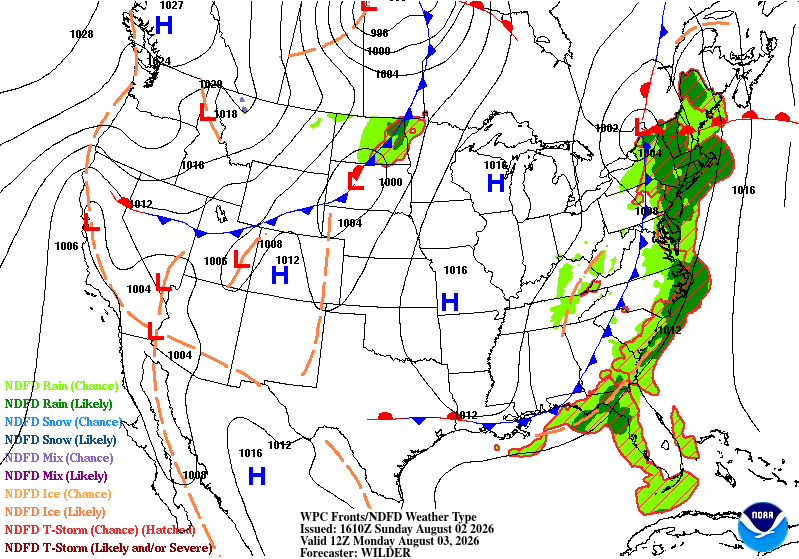
A bit off here. HP will slide E with a front moving in with scattered shwrs/stms.

-
August 2 1831: Unseasonably cool air moves into Minnesota with light frost reported at Ft. Snelling. For Sunday, August 2, 2026 1954 - Severe thunderstorms produced golf ball size hail for thirty minutes in north central Kansas. One drift measured 200 feet long, seventy feet wide and three feet deep. (The Weather Channel) 1975 - Record heat gripped New England. Highs of 104 degrees at Providence, RI, and 107 degrees at Chester and New Bedford, MA, established state records. The heat along the coast of Maine was unprecedented, with afternoon highs of 101 degrees at Bar Harbor and 104 degrees at Jonesboro. (The Weather Channel) 1987 - Hot weather continued in the central U.S. Fifteen cities reported record high temperatures for the date, including Concordia KS with a reading of 106 degrees, and Downtown Kansas City, MO, with a high of 105 degrees. Evening thunderstorms produced severe weather in the Ohio Valley and the north central U.S. Thunder- storms in South Dakota produced wind gusts to 70 mph at Philip, and hail two inches in diameter at Faulkton. (Storm Data) (The National Weather Summary) 1988 - Searing heat continued from the Middle and Upper Mississippi Valley to the Middle and Northern Atlantic Coast States. Twenty- six cities reported record high temperatures for the date. Chicago IL reported a record seven days of 100 degree heat for the year. (The National Weather Summary) 1989 - Low pressure representing the remains of Hurricane Chantal deluged north central Texas with heavy rain. Up to 6.50 inches drenched Stephens County, and Wichita Falls reported 2.22 inches of rain in just one hour. Bismarck, ND, reported a record warm morning low of 75 degrees, and record hot afternoon high of 101 degrees, and evening thunderstorms in North Dakota produced wind gusts to 78 mph at Lakota. Early evening thunderstorms in Florida produced high winds which downed trees at Christmas. (Storm Data) (The National Weather Summary) Observances: 2 Sun American Family Day 2 Sun National Ex-Girlfriend Day (Note: Really? Guess there's a day for most everything) 2 Sun National Friendship Day 2 Sun Sisters' Day 2 Sun National Coloring Book Day 2 Sun National Ice Cream Sandwich Day (Note: have 2 big boxes in the freezer right now. Good stuff ) 2 Sun National CAD Day
-
Pretty seasonable wx here in town the next few days with highs in the 70's, and a Lake breeze from the E/NE. Only picked up a few hundredths of rain yesterday as it petered out. Next chance looks to be Mon night into Tues morning.
-
August 1 1955: A thunderstorm in Becker County dumps a foot of rain at Callaway. For Saturday, August 1, 2026 1954 - Mount Rainier in Washington State was still covered with sixteen inches of snow at the 5500 foot level following a big snow season. (David Ludlum) 1985 - A nearly stationary thunderstorm deluged Cheyenne, WY, with rain and hail. Six inches of rain fell in six hours producing the most damaging flash flood of record for the state. Two to five feet of hail covered the ground following the storm, which claimed twelve lives, and caused 65 million dollars property damage. (Storm Data) 1986 - A powerful thunderstorm produced 100 mph winds and large hail in eastern Kansas and southwestern Missouri causing 71 million dollars damage, and injuring nineteen persons. It was one of the worst thunderstorms of record for Kansas. Crops were mowed to the ground in places and roofs blown off buildings along its path, 150 miles long and 30 miles wide, from near Abilene to southeast of Pittsburg. (The Weather Channel) 1987 - Record heat gripped parts of the Midwest. A dozen cities reported record high temperatures for the date, including Lincoln, NE, with a reading of 105 degrees, Moline, IL, with an afternoon high of 103 degrees, and Burlington, IA, with a reading of 102 degrees. (The National Weather Summary) 1988 - Two dozen cities in the Upper Midwest reported record high temperatures for the date, including La Crosse WI with a reading of 105 degrees. Highs of 103 degrees at Milwaukee, WI, and South Bend, IN, were records for the month of August. (The National Weather Summary) 1989 - Hurricane Chantal made landfall along the Upper Texas coast about sunrise. Chantal deluged parts of Galveston Island and southeastern Texas with 8 to 12 inches of rain. Unofficial totals ranged up to twenty inches. Winds gusted to 82 mph at Galveston, and reached 76 mph in the Houston area. Tides were 5 to 7 feet high. The hurricane claimed two lives, and caused 100 million dollars damage. (The National Weather Summary) Observances: 1 Sat National Sunflower Day 1 Sat International Childfree Day 1 Sat National Minority Donor Awareness Day 1 Sat World Scout Scarf Day 1 Sat National Girlfriend Day 1 Sat Colorado Day 1 Sat World Lung Cancer Day 1 Sat Lammas Day 1 Sat World Breastfeeding Week 1 Sat Homemade Pie Day 1 Sat International Can-It Forward Day 1 Sat National Planner Day 1 Sat National Raspberry Cream Pie Day 1 Sat National Promise to Care Day 1 Sat Play Ball Day 1 Sat Respect For Parents Day 1 Sat Rounds Resounding Day 1 Sat Spider-Man Day 1 Sat Start Up Day Across America 1 Sat Woman Astronomers Day 1 Sat World Wide Web Day
-
DLH had an avg July temp of 71.2, 3rd warmest. Very warm! Out of 80 unique temps recorded since 1874, midpoint temp is 66.0. PWS near old wx bureau site had 71.8, which would have been 2nd. DLH picked up 2.41" of rain yesterday. 4.69" for the month. That put them above avg by 0.77". But in contrast, TH coop had a avg temp of 63.2. That tied 45th warmest out of 73 unique temps since 1894. Midpoint temp is 64.2. Much cooler along the shoreline. 2.49" of precip fell short of avg (4.05").
-
July 31 1961: Very heavy rain falls at Albert Lea, where 6.7 inches is recorded in 24 hours. For Friday, July 31, 2026 1976 - A stationary thunderstorm produced more than ten inches of rain which funneled into the narrow Thompson River Canyon of northeastern Colorado. A wall of water six to eight feet high wreaked a twenty-five mile path of destruction from Estes Park to Loveland killing 156 persons. The flash flood caught campers, and caused extensive structural and highway damage. Ten miles of U.S. Highway 34 were totally destroyed as the river was twenty feet higher than normal at times. (David Ludlum) (The Weather Channel) 1986 - The temperature at Little Rock, AR, soared to 112 degrees to establish an all-time record high for that location. Morrilton, AR, hit 115 degrees, and daily highs for the month at that location averaged 102 degrees. (The Weather Channel) 1987 - The deadliest tornado in 75 years struck Edmonton, Alberta, killing 26 persons and injuring 200 others. The twister caused more than 75 million dollars damage along its nineteen mile path, leaving 400 families homeless. At the Evergreen Mobile Home Park, up to 200 of the 720 homes were flattened by the tornado. (The National Severe Storms Forecast Center) 1987 - Afternoon highs of 106 degrees at Aberdeen, SD, and 102 degrees at Ottumwa, IA, and Rapid City, SD, established records for the date. It marked the seventh straight day of 100 degree heat for Rapid City. Baltimore, MD, reported a record twenty-two days of 90 degree weather in July. Evening thunderstorms produced golf ball size hail at Lemmon, SD, and wind gusts to 80 mph at Beulah, ND. (The National Weather Summary) (Storm Data) 1988 - Twenty-one cities in the north central U.S. reported record high temperatures for the date, including Sioux City, IA, with a reading of 107 degrees. The reading of 105 degrees at Minneapolis, MN, was their hottest since 1936. Pierre and Chamberlain, SD, with highs of 108 degrees, were just one degree shy of the hot spot in the nation, Palm Springs, CA. (The National Weather Summary) 1989 - Overnight thunderstorms soaked eastern Kansas and western Missouri with heavy rain. Four and a half inches of rain was reported at Nevada, MO. Evening thunderstorms in Oklahoma produced wind gusts to 75 mph at Covington. Six cities in the north central U.S. reported record high temperatures for the date, including Williston, ND, with a reading of 105 degrees. (Storm Data) (The National Weather Summary) Observances: 31 Fri World Ranger Day 31 Fri National Avocado Day 31 Fri National Mutt Day 31 Fri Harry Potter Birthday 31 Fri Lifeguard Appreciation Day 31 Fri National Jump for Jelly Beans Day 31 Fri National Raspberry Cake Day 31 Fri Shredded Wheat Day 31 Fri Uncommon Instrument Awareness Day 31 Fri Hawaii Flag day
-
Rain incoming. Hopefully a soaker this morning.
-
85/71/90 this aftrn. Muggy. Hoping for stms later. Lake is getting warmer. The light SSW wind today (5-15 mph) bringing in some Lake air, but not really affecting temps as much now. 10C/50F offshore to 16C/61F down near DLH. Still cool, but warmer air is able to overwhelm near lake surface air temp easier now.
-
July 30 1971: A cool spell across Minnesota brings frost to northern Minnesota. Freezing temperatures are reported as far south as Pipestone. For Thursday, July 30, 2026 1949 - The state record for Connecticut was established when the town of Greenville registered an afternoon high of 102 degrees. (The Weather Channel) 1965 - The temperature at Portland, OR, reached 107 degrees to equal their all-time record high. (The Weather Channel) 1979 - A forty-minute hailstorm bombed Fort Collins, CO, with baseball to softball size hail. Two thousand homes and 2500 automobiles were damaged, and about 25 persons were injured, mainly when hit on the head by the huge stones. A three month old baby died later of injuries. (The Weather Channel) 1987 - Afternoon highs of 105 degrees at Aberdeen SD, 102 degrees at Bismarck, ND, and 102 degrees at Pueblo, CO, were records for the date. Pueblo, CO, reported just .09 inch of rain for the first thirty days of the month. (The National Weather Summary) 1988 - A dozen cities in the north central and northeastern U.S. reported record high temperatures for the date. Downtown Baltimore, MD, hit 103 degrees, marking a record eight days of 100 degree heat for the month, and ten for the year. The high of 101 degrees at Billings, MT, marked a record seventeen days of 100 degree heat for the year. Thunderstorms produced severe weather in the northeast, with nearly fifty reports of large hail or damaging winds in Pennsylvania and New York State. A tree fell on a car at Erie, PA, injuring four persons. (The National Weather Summary) (Storm Data) 1989 - Morning thunderstorms over central Missouri deluged Columbia with 5.98 inches of rain causing flash flooding. Daytime thunderstorms in Kentucky drenched Paducah with 1.73 inches of rain in less than half an hour. Evening thunderstorms in the north central U.S. produced wind gusts to 78 mph east of Moccasin, MT. (The National Weather Summary) (Storm Data) Observances: 30 Thu National Cheesecake Day 30 Thu National Father-in-Law Day 30 Thu World Day Against Trafficking in Persons 30 Thu International Friendship Day 30 Thu National Intern Day 30 Thu International Day of Friendship 30 Thu National Support Public Education Day 30 Thu National Whistleblower Day 30 Thu Paperback Book Day 30 Thu Share a Hug Day 30 Thu World Snorkeling Day
-
Squeaked out an 80/70 this aftrn. Comfortably warm.
-
Haven't seen that. Did a search, and seems a doc was done on this, and is posted on YT. Will have to look at that sometime.
-
July 29 1917: The hottest temperature ever recorded in Minnesota, 114.5 degrees, occurs at Beardsley. 1849: Severe storms hit the newly constructed post of Ft. Ripley between 3 and 5 AM. W.J. Frazier, Head Surgeon notes: 'Rain and hail with much thunder and lightning and very high winds breaking many trees.' For Wednesday, July 29, 2026 1898 - The temperature at Prineville, OR, soared to 119 degrees to establish a state record, which was tied on the 10th of August at Pendleton. (The Weather Channel) 1905 - Heavy rain in southwestern Connecticut caused a dam break, and the resulting flood caused a quarter of a million dollars damage at Bridgeport. As much as eleven inches of rain fell prior to the flood. (David Ludlum) 1981 - Fifty cattle, each weighing 800 pounds, were killed by lightning near Vance, AL. The lightning struck a tree and then spread along the ground killing the cattle. (The Weather Channel) 1987 - Thunderstorms produced severe weather from Minnesota to Indiana and Illinois. A thunderstorm at Janesville, WI, produced wind gusts to 104 mph which flipped over two airplanes, and blew another plane 300 feet down the runway. The northeastern U.S. experienced some relief from the heat. Nine cities reported record low temperatures for the date, including Saint Johnsbury, VT, with a reading of 42 degrees. Barnet, VT, reported a morning low of 33 degrees, with frost reported on vegetation. (Storm Data) (The National Weather Summary) 1988 - Afternoon and evening thunderstorms produced severe weather in Minnesota and Wisconsin. Hail three inches in diameter was reported south of Saint Cloud, MN. Hot weather prevailed in the western U.S. Fresno, CA reported a record thirteen straight days of 100 degree heat. (Storm Data) (The National Weather Summary) 1989 - Morning thunderstorms in the Upper Midwest produced more than five inches of rain west of Virgil, SD. Afternoon and evening thunderstorms deluged the foothills and adjacent plains of Colorado with heavy rain. Rains of six to seven and a half inches fell in eight hours north of Greeley. Hail and heavy rain caused several million dollars damage in Weld County. (Storm Data) (The National Weather Summary) Observances: 29 Wed National Chicken Wing Day 29 Wed National Rain Day 29 Wed National Lasagna Day 29 Wed NASA is Founded 29 Wed International Tiger Day 29 Wed National Lipstick Day 29 Wed Cheese Sacrifice Purchase Day 29 Wed National Challenged Champions and Heroes Awareness Day 29 Wed National Get Gnarly Day 29 Wed National Wing Day
-
Historically, the SW US is a dry region. A few decades of wetter years allowed for strong pop growth. TBH, wouldn't surprise me to see ghost towns by century end, just like mining ghost towns. The water that gets pumped out of the ground leaves cavities empty, and they collapse. No longer able to refill. Some places are just not meant to have big pops.
-
Heat adv out for NE MN & N WI except near the Lake. Very pleasant wx yesterday in the 70's with the same today.
-
July 28 1987: Heavy rain falls at La Crosse, WI, where 5 inches are recorded. For Tuesday, July 28, 2026 1819 - A small but intense hurricane passed over Bay Saint Louis, MS. The hurricane was considered the worst in fifty years. Few houses were left standing either at Bay Saint Louis or at Pass Christian, and much of the Mississippi coast was desolate following the storm. A U.S. cutter was lost along with its thirty-nine crew members. The storm struck the same area that was hit 150 years later by Hurricane Camille. (David Ludlum) 1930 - The temperature at Greensburg, KY, soared to 114 degrees to set a state record. (The Weather Channel) 1934 - The temperature at Grofino, ID, climbed to 118 degrees to establish a record for Idaho. (The Weather Channel) 1952 - A severe storm with hail up to an inch and a half in diameter broke windows, ruined roofs, and stripped trees of leaves near Benson, AZ. The temperature dropped to 37 degrees, as hail was three to four inches deep, with drifts 46 inches high. (The Weather Channel) 1986 - Severe thunderstorms moving out of South Dakota across Iowa produce high winds which derailed eighteen piggyback trailer cars of a westbound freight train near Boone, IA. Sixteen of the cars fell 187 feet into the Des Moines River. The thunderstorms also spawned a number of tornadoes, including one which caused twenty-five to fifty million dollars damage at Sloan, near Sioux City, IA. (Storm Data) 1987 - Thunderstorms in Nevada produced wind gusts to 70 mph at Searchlight, reducing visibilities to near zero in blowing dust and sand. Thunderstorms in Montana drenched Lonesome Lake with 3.78 inches of rain. (The National Weather Summary) 1988 - Thunderstorms drenched Wilmington, NC, with 3.33 inches of rain, bringing their monthly total 14.46 inches. Seven cities in Michigan and Minnesota reported record high temperatures for the date. Marquette, MI, hit 99 degrees, and the record high of 94 degrees at Flint MI was their tenth of the month. (The National Weather Summary) 1989 - Afternoon thunderstorms produced large hail and damaging winds in Massachusetts. Early evening thunderstorms over Florida produced wind gusts to 68 mph at Fort Myers, and evening thunderstorms in South Dakota produced nearly two inches of rain in twenty minutes at Pierpoint. (The National Weather Summary) (Storm Data) Observances: 28 Tue National Milk Chocolate Day 28 Tue Bonus Army 28 Tue World War I 28 Tue World Hepatitis Day 28 Tue Buffalo Soldiers Day 28 Tue National Soccer Day 28 Tue National Waterpark Day 28 Tue World Nature Conservation Day
-
Midnight high of 76. Been in the 60's today. Early Fall feel again. Chilly actually.
-
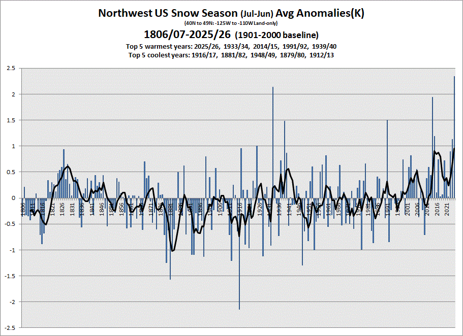
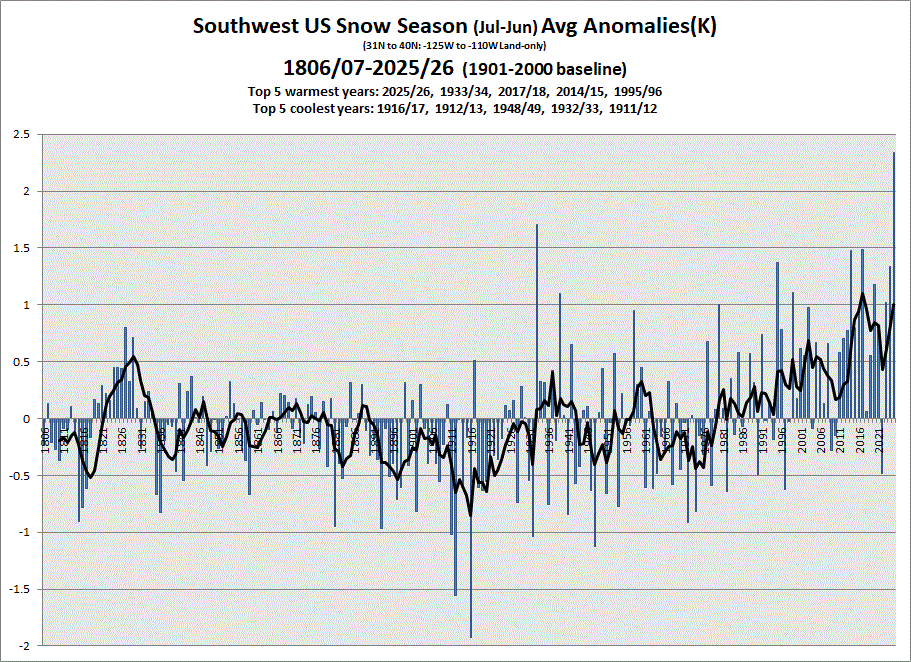
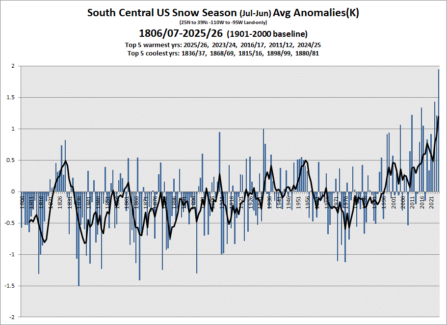
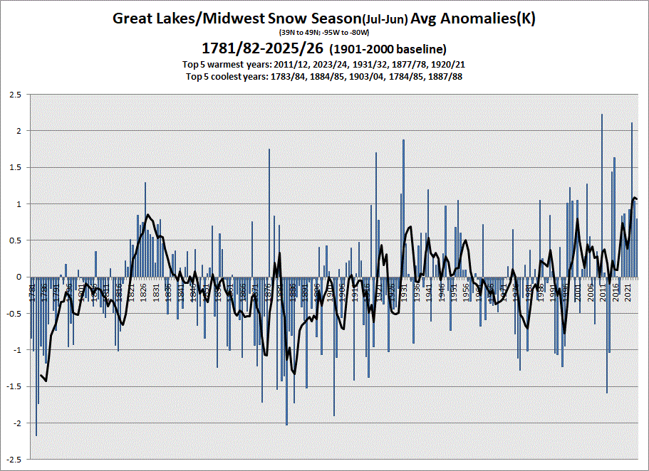
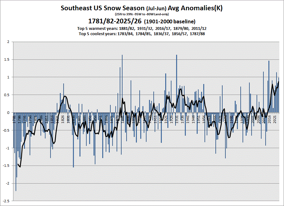
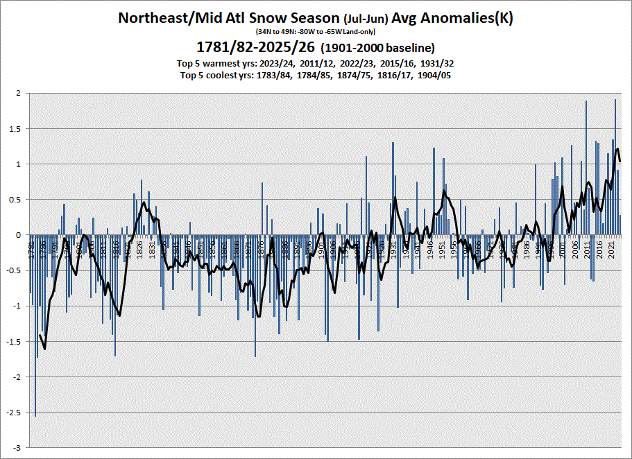
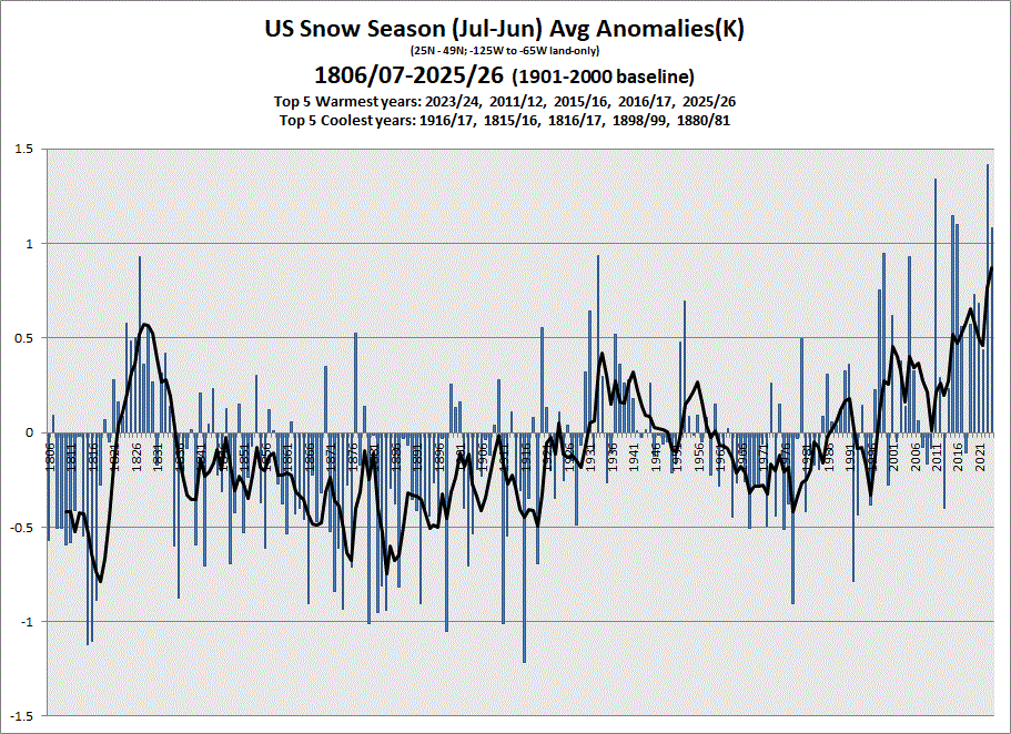
Finished up updating datasets. I have charting for different sections of the US. Since we ended the 25/26 snow season, I'm posting the snow season charts for the 7 sections of the US plus the US as a whole. Only have data back to 1806 for the western half of the country, so the US chart starts there, also.

-
July 27 1910: Giant hailstones fall in Todd and Wadena Counties. One stone weighed in at 5 pounds. For Monday, July 27, 2026 1926 - A hurricane came inland near Daytona Beach, FL. The hurricane caused 2.5 million dollars damage in eastern Florida, including the Jacksonville area. (David Ludlum) 1939 - The temperature at Lewiston, ID, hit 117 degrees to establish an all-time record high for that location. (The Weather Channel) 1943 - On a whim, and flying a single engine AT-6, Lieutenant Ralph O'Hair and Colonel Duckworth were the first to fly into a hurricane. It started regular Air Force flights into hurricanes. (The Weather Channel) 1987 - Thunderstorms in Minnesota spawned a tornado which moved in a southwesterly direction for a distance of thirty miles across Rice County and Goodhue County. Trees were uprooted and tossed about like toys, and a horse lifted by the tornado was observed sailing horizontally through the air. Thunderstorms drenched La Crosse, WI, with 5.26 inches of rain, their second highest 24 hour total of record. (The National Weather Summary) (Storm Data) 1988 - Hot weather prevailed in the north central U.S. Williston, ND, reported a record high of 108 degrees. Thunderstorms produced severe weather in the eastern U.S., and in southeastern Texas. Richland County, SC, was soaked with up to 5.5 inches of rain. (The National Weather Summary) 1989 - Thunderstorms produced locally heavy rains in the southwestern U.S. Yuma, AZ, experienced their most severe thunderstorm of record. Strong thunderstorm winds, with unofficial gusts as high as 95 mph, reduced visibilities to near zero in blowing dust and sand. Yuma got nearly as much rain in one hour as is normally received in an entire year. The storm total of 2.55 inches of rain was a record 24 hour total for July. Property damage due to flash flooding and high winds was in the millions. (Storm Data) 1989 - Thunderstorms produced severe weather from Wisconsin and northern Illinois to New England, with 103 reports of large hail and damaging winds through the day. Thunderstorms in Wisconsin produced hail three inches in diameter near Oshkosh, and wind gusts to 65 mph at Germantown. (The National Weather Summary) Observances: 27 Mon National Scotch Day 27 Mon National Creme Brûlée Day 27 Mon Barbie-in-a-Blender Day 27 Mon Cross Atlantic Communication Day 27 Mon National Chicken Finger Day 27 Mon National Korean War Veterans Armistice Day 27 Mon National Love is Kind Day 27 Mon National New Jersey Day 27 Mon National Roanoke Community Beautification Day 27 Mon Take Your Houseplant For A Walk Day 27 Mon Take Your Pants for a Walk Day 27 Mon Walk On Stilts Day 27 Mon Gary Gygax Day
-
Breezy Lake winds today. Actually feels nice. Looks like 0.02"-0.83" of rain around TH from last night.
-
Peaked 85/76/95 here in town today. Muggy! Cloudy most of the day, but when the sun did peak out temp jumped. Midday, then again during the evening. Some shwrs/stms passed thru, but not much fell.
-
Svr wx possible around the Northland tonight. But there is a cap in play, so we'll see what can break that.
-
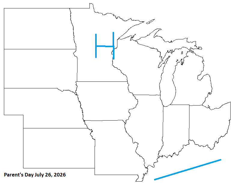
July 26 1981: A chilly morning occurs across the Northland, with 33 degrees at Roseau and Wannaska. For Sunday, July 26, 2026 1819 - Twin cloudbursts of fifteen inches struck almost simultaneously at Catskill, NY, and Westfield, MA. Flash flooding resulted in enormous erosion. (David Ludlum) 1943 - Tishomingo, OK, baked in the heat as the mercury soared to 121 degrees, a state record. (The Weather Channel) 1960 - The temperature at Salt Lake City, UT, hit 107 degrees, an all-time record high for that location. (The Weather Channel) 1987 - Thunderstorms developing along a cold front produced hail two inches in diameter in McHenry County, IL, and wind gusts to 70 mph at Auburn, ME. A wind gust of 90 mph was recorded at Blairstown, NJ, before the anemometer broke. The high winds were associated with a small tornado. The record high of 88 degrees at Beckley, WV, was their sixth in a row. (The National Weather Summary) (Storm Data) 1988 - Thunderstorms produced large hail and damaging winds in the Middle Atlantic Coast Region, and in the south central U.S. Eight cities in the northwestern and north central U.S. reported record high temperatures for the date. Salem, OR, hit 103 degrees. (The National Weather Summary) 1989 - Morning thunderstorms produced heavy rain in southeastern Texas, with more than three inches reported at the Widllife Refuge in southwestern Chambers County. Evening thunderstorms produced severe weather in Montana, with wind gusts to 62 mph reported at Helena. Eight cities from Maine to Minnesota reported record high temperatures for the date, including Newark, NJ, with a reading of 99 degrees. (The National Weather Summary) (Storm Data) Observances: 26 Sun Uncle and Aunt Day 26 Sun Parents' Day 26 Sun National Disability Independence Day 26 Sun Auntie's Day 26 Sun Holistic Therapy Day 26 Sun National All or Nothing Day 26 Sun National Bagelfest Day 26 Sun National Coffee Milkshake Day 26 Sun National Saint Day 26 Sun One Voice Day 26 Sun World Mangrove Day 26 Sun World Tofu Day 26 Sun National Aunt and Uncle Day
-
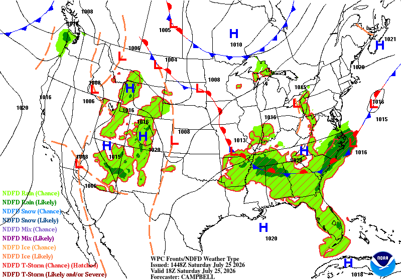
Cloudy morning. Suppose to be sunny today with stms tonight. Heat adv out. DLH is under Heat warning. Yesterday was 80 with a 70 dew. Muggy, but comfortable. We'll see if it warms more today. Point has 82.
-
As expected. Highs hovering around 80 in the area. Point fail.
-
Too aggressive bringing in HP. Would have been a good cast for earlier this past week, tho, when HP moved in, and cooled things off pretty good.