

csnavywx
-
Posts
5,730 -
Joined
-
Last visited
Content Type
Profiles
Blogs
Forums
American Weather
Media Demo
Store
Gallery
Everything posted by csnavywx
-

Southern MD / Lower Eastern Shore weather discussion
csnavywx replied to AnEndlessMaze's topic in Mid Atlantic
Hearing the occasional branch crash outside. Ice casing on the sleetpack is thick enough to be relatively difficult to break now. -
Southern MD / Lower Eastern Shore weather discussion
csnavywx replied to AnEndlessMaze's topic in Mid Atlantic
About a quarter inch of glaze so far. -
Southern MD / Lower Eastern Shore weather discussion
csnavywx replied to AnEndlessMaze's topic in Mid Atlantic
Temp should mostly stall or only very slowly rise once the winds flip NW. Hour or two? -
Southern MD / Lower Eastern Shore weather discussion
csnavywx replied to AnEndlessMaze's topic in Mid Atlantic
Have been getting absolutely crapped on by freezing rain. Lost what sleet was left about 45m-1hr ago. 29F. -
Freezing rain and 27 degrees here. Only 3 hours til sunset, wind has shifted northwest. 0.5-0.75 of liquid to go. Wish me luck. If we can't break above 30 before dark, it's going to get nasty here.
-
Southern MD / Lower Eastern Shore weather discussion
csnavywx replied to AnEndlessMaze's topic in Mid Atlantic
26F, Freezing rain has begun. Light glaze so far. -
Southern MD / Lower Eastern Shore weather discussion
csnavywx replied to AnEndlessMaze's topic in Mid Atlantic
That's an impressive coastal front. I wasn't thinking you'd get much in the way of ice out there. But there's a chance that front gets pushed back through later this evening before the last line of precipitation is through and it might give you a glaze. Up in the air at this point since we're so far away from almost any guidance at this point. -
Pounding sleet and needles still. Some of the highest rates of sleet I've seen. Vis about half a mile.
-
Southern MD / Lower Eastern Shore weather discussion
csnavywx replied to AnEndlessMaze's topic in Mid Atlantic
Wild. How much are you up to? -
Southern MD / Lower Eastern Shore weather discussion
csnavywx replied to AnEndlessMaze's topic in Mid Atlantic
Ehhhhhhhh....Highest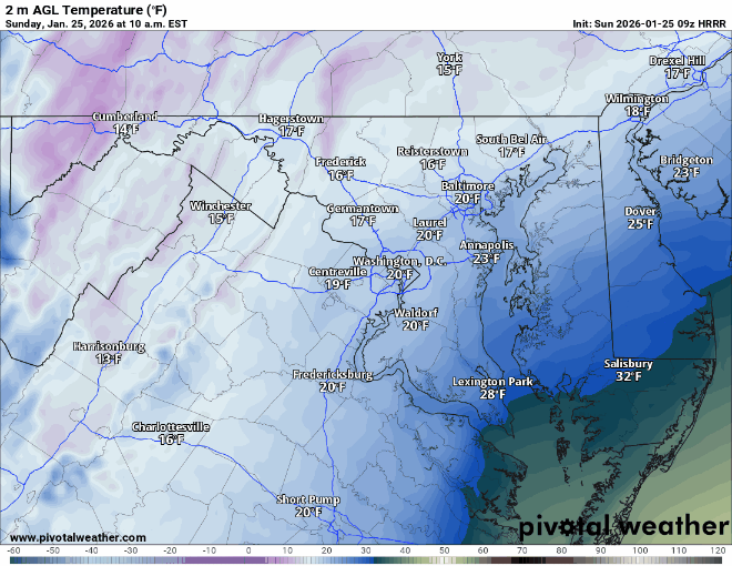
-
Yep. I'm getting primarily needles, which would match up with that.
-
Update: Still sleeting but back to feeder-generated powder snow that's actually accumulating.
-
I got a couple of hours of seeder-generated powder snow after flipping to sleet. That CAD is some serious business.
-
Southern MD / Lower Eastern Shore weather discussion
csnavywx replied to AnEndlessMaze's topic in Mid Atlantic
The models that seem to verify best right now are the AI-GFS and EC-AIFS models (with the HRDPS coming the closest among the traditionals -- it slowed down the coastal front more than the others). EC-AIFS has you getting above freezing, but only briefly this afternoon and interestingly, neither of us get above freezing on the AI-GFS now. The slow-moving coastal front scenario and temps staying down more than forecast was a big worry for us at the office. Warm noses and CAD are something NWP in general can have a tough time with. We purposefully hedged lower on temps. Maybe not enough. We'll see. -
Southern MD / Lower Eastern Shore weather discussion
csnavywx replied to AnEndlessMaze's topic in Mid Atlantic
Well the mesos all have everyone just south and east of Salisbury above freezing already. They're struggling a bit with this sharp coastal front that has developed. -
Southern MD / Lower Eastern Shore weather discussion
csnavywx replied to AnEndlessMaze's topic in Mid Atlantic
We flipped a while ago. But the sub-warm nose layer is so cold we are mixing fine powdery snow (from precip seeding) again. Pretty nice bonus. -
Little bit of good news. The sub-warm nose layer is so cold we're getting snow to develop out of it (from precip seeding from above). Pouring clear ice pellets with a nice powder/pixie dust to go with it. Vis notably restricted.
-
3" on ground. Pouring sleet here. Transitioned over a period of about 90 minutes. Coming down hard enough that it's still accumulating.
-
Southern MD / Lower Eastern Shore weather discussion
csnavywx replied to AnEndlessMaze's topic in Mid Atlantic
3" on ground. Pouring sleet now. 18F. Coastal front appears to be set up over on the lower eastern shore (coastal side), but moving a bit slower than forecasted. -
One of the reasons this is being detected early is probably because the primary shortwave is already an entity over the Pacific east of Japan.
-
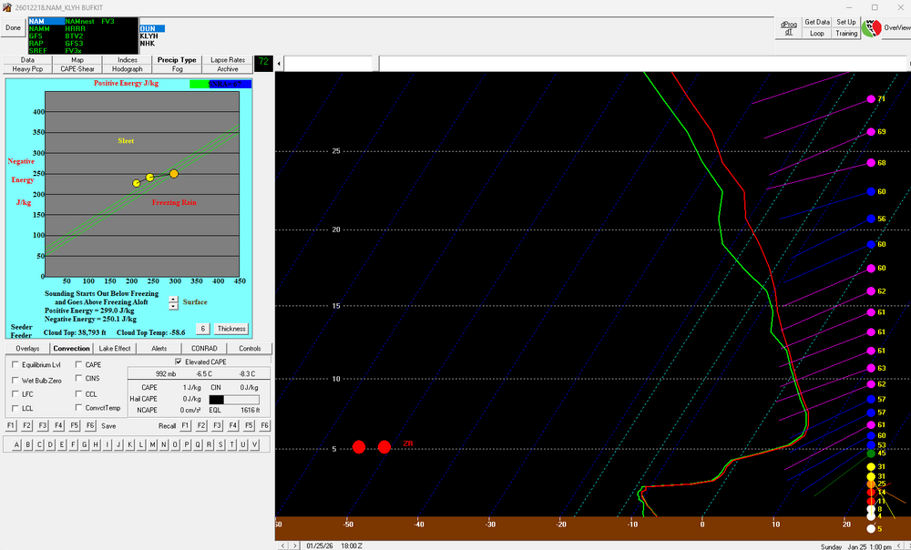
Good thing is, even on a super aggressive warm nose solution like the 18Z NAM, you may not be completely cooked: Switches over to PL at 2:00am or so at LYH, but it takes until about 1:00pm for it to transition over to ZR. About 0.5" liquid falls as ZR in this run.

-
Best you can reasonably hope for is to get stuck in a melting-enhanced band embedded in some intense frontogenesis and really crank for a couple of hours before changeover.
-
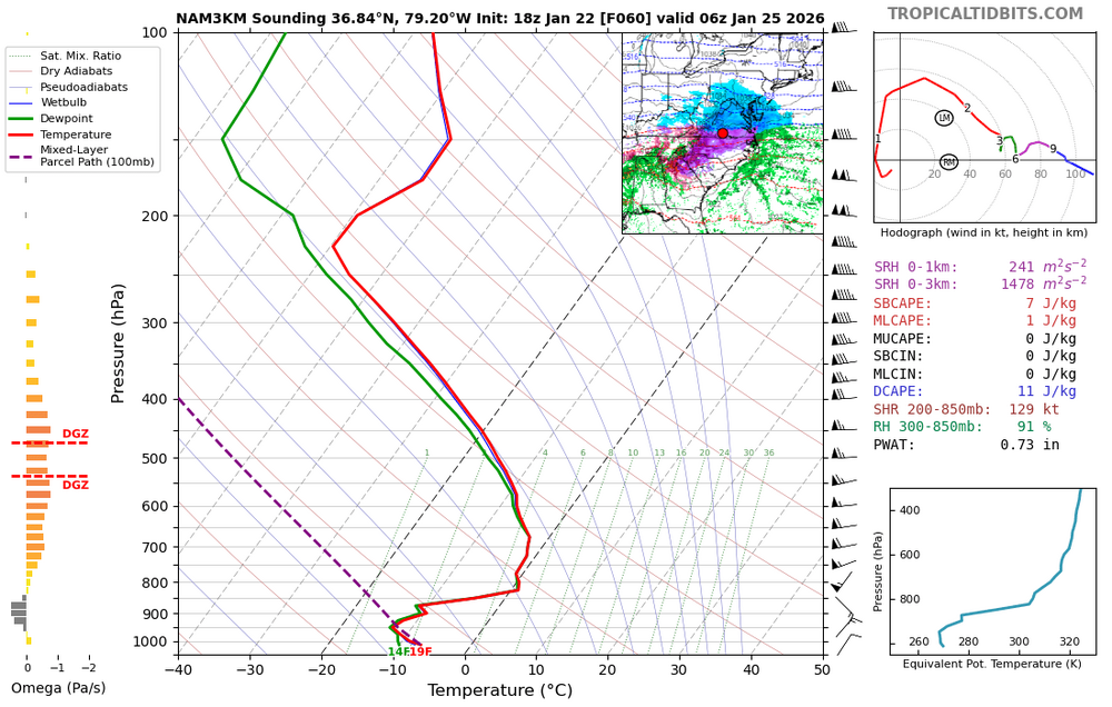
Careful. Vertical resolution on TT Euro maps is limited to the standard levels. Devil is in the details:
-
Southern MD / Lower Eastern Shore weather discussion
csnavywx replied to AnEndlessMaze's topic in Mid Atlantic
Fret not. Even if we only get a partial here, the pattern remains very favorable into Feb. Need some true vodka cold to start freezing the Bay up in preparation, if you ask me. -
Southern MD / Lower Eastern Shore weather discussion
csnavywx replied to AnEndlessMaze's topic in Mid Atlantic
Run to run variability has calmed down since 00Z last night and while I think we get a bit more adjustment south/slower, it's probably not going to be enough to save the eastern shore from changing over to all rain at this point. Enjoy the front-end thump, it'll probably only last a few hours before flipping to sleet and (briefly) ZR. Inshore is going to have a rough time of it, especially immediately away from the Bay. Hopefully we get near or just above freezing here late Sunday and at least pause the icing before it starts back up overnight. 3-6" Eastern Shore + 1" sleet, then brief freezing rain to rain; DE side will get more snow (add an inch or two) before changeover to sleet. 4-9" inshore southern MD, + 1" sleet, then 0.25-0.75" ZR A band of heavy convective rain showers is looking increasingly possible overnight Sunday into early Monday morning. If the coastal has developed sufficiently, then northwest flow should advect the remaining CAD wedge back into the inshore area and result in some additional quick accretion of ZR overnight. Am a bit concerned about some freezing drizzle and/or light snow on Monday ahead of the big upper trough. Still some moisture left below 700mb after the dry slot comes through.


