

csnavywx
-
Posts
5,543 -
Joined
-
Last visited
Content Type
Profiles
Blogs
Forums
American Weather
Media Demo
Store
Gallery
Posts posted by csnavywx
-
-
2 minutes ago, Eskimo Joe said:
Always use 500mb over surface progression until your inside of 72 hours.
I prefer starting there too. In this case, I would not expect the GFS to cover the gap between it and the EC in just one run, esp since previous runs weren't getting most of the snow from the coastal and the developing mid-level low. So, if it's heading that direction, you'd *expect* to see a dip in QPF first, then rise again if it latches onto more of an EC-type evolution.
-
 7
7
-
 1
1
-
-
Should reaaaaaally do a dprog/dt with H5 and MSLP before panicking. Trending towards the northern coastal solution with time (e.g. what the 12Z EC and EPS printed out).
-
12
-
 1
1
-
-
EPS inched up to 0.8-1.0" liquid mean.
-
1
-
-
Overamps the NS wave, brings in warm air aloft and delays the coastal. GEM delayed the coastal from the other end (prob partially due to diabatic/latent heating). 12Z EC doesn't and it's right through the uprights. In fact, if I were going to draw us up a near-perfect setup, that EC run from 96-120h is pretty hard to beat. 700mb low develops just west and flow goes *SE* with some 1-3"/hr rates in there likely.
-
1
-
-
At first glance, it's just having some issues with convection and latent heat/diabatic processes near the Gulf Stream that cause a delay in coastal development. Wouldn't be heading to the panic room over it.
-
7
-
5
-
-
I'd do your shopping this weekend. If it goes full KU/Miller A, and it's starting to lean that way, then you don't want to be fighting the madhouse when that news gets out.
-
4
-
-
1 minute ago, MillvilleWx said:
Welp, it might be time to start really paying close attention to this one ladies and gents. Still not etched in stone, but Donatello is probably getting his tools ready
100%. Doing my shopping today before people lose their collective minds. Remember the gas, rock salt, matches and cash.
-
3
-
 2
2
-
-
Time to unlock that thread, Randy.
-
3
-
4
-
-
00Z suite was made from pure snow weenie dreams.
-
3
-
-
6 minutes ago, gymengineer said:
That trajectory reminds me a lot of 2/6-7/03.
https://www.raymondcmartinjr.com/weather/2003/07-Feb-03.html
Looks similar. Ceiling on this one could be a bit higher.
In my experience, the big dogs are usually pretty synoptically obvious and show up on guidance earlier than most events. Solution stability brought on by larger, more stable parts. The PV streamer that comes off the Hudson Bay TPV and the timing of the southern stream shortwave are probably the parts with the biggest slippage, but given that these are currently large, stable systems means it's rather unlikely all of this is a hallucination.
-
15
-
-
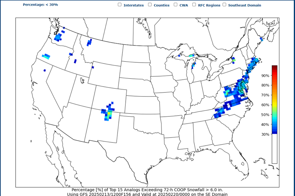
CIPS analog system at T+156 with a signal here.
-
4
-
-
6 minutes ago, AlexD1990 said:
I thought this upcoming storm was progged for Tuesday Wednesday?
Willing to bet it'll end up more like Wed. aftn/overnight into Thu.
-
1
-
-
2 minutes ago, Lowershoresadness said:
what are we looking for upstairs to max our totals and what could cause up problems?
Wave timing and phasing, basically. A big dog will require the southern stream and northern stream to have a well-timed phase. Even a partial phase can produce decent totals here, so we don't need it to be perfect. The advantage this go-around is that both players are already on the board and are fairly large-scale (one is a large vort/TPV over the Husdon Bay and the other is a large system south of the Aleutians), so it's unlikely this is some hallucination. Most of the volatility is from the vort streamer from the Hudson Bay TPV -- basically the energy that gets left behind underneath the block that's breaking down. If the southern stream is too slow or the PV streamer is too far west or doesn't materialize to the strength that is currently progged, then those could cause some fail modes.
-
1
-
-
3 minutes ago, AlexD1990 said:
Definitely impressive agreement for this lead time. Should be a much colder storm than yesterday too.
Yep. Having it come in just 2-3 days behind this weekend's system is going to help quite a bit. Bulk of the CAA is on Monday, so only a short time for airmass modification before this one arrives. This weekend's system also doesn't entirely scour the Gulf either, leaving some room for return flow to tap in some moisture.
-
Notable that every single piece of guidance today has an event at D6-D7 and the spread is unusually small for this distance.
-
20 hours ago, Lowershoresadness said:
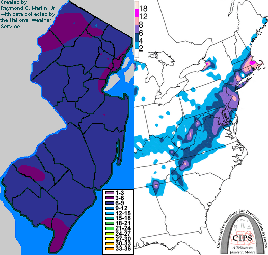
from the Southeastern forum. Lets not sleep on next week
.thumb.png.14897baaacbe339e6b2c3f3dfa6bcbdd.png)
Most guidance has come around to a slider/Hatteras track. Still some wiggle room, but the "waveguide" looks good. Hard to be upset at the general setup 6-7 days out.
-
7 hours ago, SnowtoRain said:
9.0" snow total, 22.75 for the year
Looking like Leonardtown-->Easton--> Sussex jackpotted in with a 9-11" band (just outside the mixing line). I thought the max amount over here in SoMD would be about 20mi further north, but very close to the final max band!
Perhaps surprising a bit were the 7+ totals all the way down to Pt. Lookout. That initial intense shove of f-gen forcing dropped some 2"/hr rates there with the first band.
Personally I ended around 6.5" with about 1.25" of sleet included in there. VERY dense snowpack. Probably 4 or 5:1.
-
1
-
-
Mixing line has stalled for now just to my north. Snow attempting to mix back in. Have just been piling on a bunch of sleet for a few hours. About .6 of that on top of 4.5" of snow.
-
Large scale pattern looks great. Titanic -AO/-NAO block that shoves in an Arctic outbreak this weekend and leaves some vort behind. Def some potential to work with there as the block weakens.
-
3
-
1
-
-
Mostly heavy sleet at this point. Still a few aggregates mixing in and some small needles and plates from the relatively deep cold layer underneath the warm nose. 4.9" measured. Compaction from the sleet layer getting significant.
I know we're still dealing with this storm until tomorrow morning but it does look like we'll get another shot around the 20th. Titanic Greenland block/-AO should push in a big outbreak of cold air after this weekend and set up a several-day-long window for a system to slide into a favorable waveguide as the block gradually weakens.
-
1
-
 1
1
-
-
Heavy sleet with some snow mixed in. 4.9". Turning into concrete. Roads are a disaster.
-
1
-
-
Mixing with sleet again. Still coming down pretty heavily.
-
11 minutes ago, SnowtoRain said:
Heavy small snowflakes, 29.5, 2 degrees colder than most models, reminds me of the January event so far, around 3"
The fact that we got a full night of radiational cooling followed by thick clouds right before sunrise definitely helped in this case.
-
Back to 1-2"/hr rates, mixing stopped. Strong lift, frontogen. circulation, and high precip rates have thusfar been pretty successful at cooling and eventually washing out these above-freezing warm nose intrusions.
-
2
-

Southern MD / Lower Eastern Shore weather discussion
in Mid Atlantic
Posted
Yeah, that SE trend can stop now. About out of room for everyone except Salisbury and Wallops.