
WhirlingWx
-
Posts
404 -
Joined
-
Last visited
Content Type
Profiles
Blogs
Forums
American Weather
Media Demo
Store
Gallery
Posts posted by WhirlingWx
-
-
Tornado emergency directly extended for Peachtree City
-
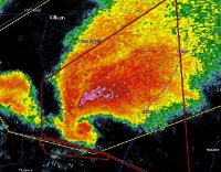
Another deep TDS and debris ball on reflectivity...
-
Mesoscale Discussion 0268
   NWS Storm Prediction Center Norman OK
   1026 PM CDT Thu Mar 25 2021

   Areas affected...parts of west-central GA

   Concerning...Tornado Watch 52...

   Valid 260326Z - 260430Z

   The severe weather threat for Tornado Watch 52 continues.

   SUMMARY...Tornado potential will maximize near the GA/AL border and
   eventually spread into the greater Atlanta exurbia through 1230 am
   EDT.  It is uncertain how far east the higher probabilities for a
   tornado will eventually develop due to increasingly marginal
   low-level moisture with east extent.

   DISCUSSION...Surface analysis indicates mid 60s deg F dewpoints
   straddling the GA/AL border in west-central GA to the east of a
   supercell with a history of producing tornadoes (likely strong) over
   east-central AL.  The latest RAP/NAM indicate lowest 100 mb mean
   mixing ratios increasing into the 13-14 g/kg range over the next
   hour with MLCAPE increasing from 750 J/kg to 1000-1200 J/kg.  The
   KFFC VAD showed 500 m2/s2 0-1km SRH within the moist/sufficiently
   unstable airmass. Current thinking is the increasingly rich
   low-level moisture (dewpoints rising from 64-65 to 66) may enable a
   greater risk for a tornado over the next hour or so.

   ..Smith.. 03/26/2021
-
Area just south of Columbiana, AL taking very heavy damage right now.
-
It might miss the core of the towns just to the south...
Radar could be distorting the image so we just can't be sure, but I'm hoping.
-
Just now, MUWX said:
Not sure they have that long.
Definitely not anymore...
-
Brent, AL has 10 minutes to get to shelter
-
Just now, MattPetrulli said:
It has broadened out since the TDS but it definitely has a scary BR appearance.
Yeah let's hope it stays that way (broadened out and not OTG)
-
Length of the warning for B'ham metro storm tells me that BMX thinks that'll be an intense-violent long-tracker as well
-
North Birmingham cell tightening up big-time as well
-
@CheeselandSkies here's the Bassfield-type signature that didn't occur last week
-
Anyone know if the first destructive long-track sup could have left an outflow boundary...? That sup would ride it for miles and miles if that were the case.
-
Storm near Forkland, AL forming a very intense meso and BWER
-
3 reported fatalities in Calhoun county, AL (where Ohatchee is located). Multiple other injuries.
-
Tornado watch for a good chunk of TN and up into the lower OV. 70/60 TOR probs
-
New tornado warning for Blount and Jefferson counties in AL
-
Couplet SW of Cave Spring, GA is becoming quite intense. The supercell structure looks like slop but it's probably being scanned from pretty high
-
2 minutes ago, CheeselandSkies said:
That one north of Tylertown looks like trouble down the road.
Please for the love of God why do supercells keep ramping up in this same exact area

-
Brian Emfinger reporting possible fatality, presumably from the Ohatchee area
 remains unconfirmed at this time
-
 1
1
-
-
1 minute ago, ATDoel said:
My neighborhood got hit hard, only minor damage to my house, one house down from me lost their roof, two houses down from their lost their entire first floor.
Glad you're okay.
-
Just now, SchaumburgStormer said:
https://livestormchasing.com/chasers/brandon.copic
Has a good look, wicked rotation
Holy sh*t
-
Copic sees large tornado again apparently, better not get close to being killed again.
-
Spann telling other news staff to get ready to shelter
-
Reminds me of when on 4/27 people were talking about how lucky we were that the tornado didn't hit south metro instead...
Definitely not trying to suggest it's at EF4-EF5 strength, just the track of it (though I fear it could continue to strengthen)
Severe Event March 25th 2021
in Southeastern States
Posted
Debris fallout signature is just sickening...