
WhirlingWx
-
Posts
404 -
Joined
-
Last visited
Content Type
Profiles
Blogs
Forums
American Weather
Media Demo
Store
Gallery
Posts posted by WhirlingWx
-
-
Also a 10% hatched TOR added for parts of MS/AL in the updated SPC outlook
-
3 minutes ago, cheese007 said:
Meanwhile Bryan is under a tornado warning...
Lots of reports of golf ball sized hail there
-
5 minutes ago, Powerball said:
Well technically, it still shows the tiniest bit of mixed level CINH, but I've seen storms break through that easily. So it's understandable why FWD has been so ominous in their discussion, especially with the strong surface convergence from the dry line. The 3km NAM does make a valiant attempt at breaking the cap though.
I just took a look at the HRRR's forecasted sounding where this evening's supercell in Central TX originated, and it had similar CINN values to what the HRRR's advertising for tomorrow afternoon/evening.
Well, yeah, I do agree. It wouldn't surprise me if we have a Wylie 2016 repeat or a cap bust at this point. Both seem well within the realm of possibility lol. Definitely is a nasty supercell pounding College Station right now, and many HRRR runs earlier showed like nothing firing up there until the storm had formed pretty much, iirc
-
16 minutes ago, Powerball said:
Cap is virtually gone too.
Still doesn't really convect here in the metro though (not that I want a supercell with baseball-sized hail roaring through DFW), so I'm just wondering what's up with that. Upper 80s surface temps, >4000 CAPE, and little CINH, is there something I'm missing? Of course, have to see what other CAMs say, but HRRR has been the most notorious at bombing areas with convection, so I feel like there's at least some significance in it not really showing much here for multiple runs.
Edit: flow is pretty bleh, but I'm not knowledgeable enough to know if it's typical for that to just suppress convention entirely.
-
6 minutes ago, MUWX said:
A special update to upgrade D3. Don’t see that often.
"AN ENHANCED RISK WAS ADDED TO PORTIONS OF NORTHEAST LOUISIANA AND CENTRAL AND SOUTHERN MISSISSIPPI. A SOUTHERN STREAM MID-LEVEL SHORTWAVE TROUGH IS FORECAST TO AMPLIFY DURING THE EVENING HOURS ON FRIDAY ACROSS EAST TEXAS AND LOUISIANA. IN RESPONSE, THE LOW-LEVEL JET IS EXPECTED TO INCREASE DURING THE EVENING/EARLY OVERNIGHT HOURS ACROSS LOUISIANA AND MISSISSIPPI. THIS STRENGTHENING LOW-LEVEL JET SHOULD INCREASE THE THREAT FOR DAMAGING WINDS AND TORNADOES DURING THE LATE OVERNIGHT FRIDAY AND EARLY MORNING HOURS SATURDAY ACROSS MAINLY CENTRAL AND SOUTHERN MISSISSIPPI."
-
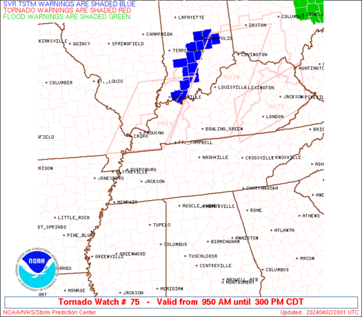
70/40 Tornado probabilities on the watch issued just now
-
 1
1
-
-
2 hours ago, cheese007 said:
D3 slight for Friday witth a sig hatch for DFW
Been a bit since we had the last billion-dollar DFW hailstorm, no?

-
 1
1
-
-
Latest update says it's down again
-
Looks like it's handing off again to a new circulation
-
2 minutes ago, StormySquares said:
VAD from Shreveport had around 300 0-3km SRH
Yeah, and with the storm turning even harder to the right it very well could be tapping into even higher SRH
-
5 hours ago, TexMexWx said:
150-200 m2/s2 seems like the lower-end for "strong" tornado potential
Well this aged poorly.
-
Storm is still turning even more to the right it seems.
-
It's probably gonna pass south of Shreveport proper on its current path at least
EDIT: Debris ball came back on reflectivity, I'm pretty sure
-
1 minute ago, Bob's Burgers said:
This is one of the more active enhanced risks, that's for sure
Getting 3/3/19 type vibes (but in a different location, obviously)
-
Geez... I didn't expect to come back to a tornado outbreak after being out for like an hour.
-
I think this one does apply more to this sub, so I'll post it here. 150-200 m2/s2 seems like the lower-end for "strong" tornado potential, but SPC thinks something's up so I guess we'll see
Mesoscale Discussion 0280
   NWS Storm Prediction Center Norman OK
   0216 PM CDT Sat Mar 27 2021

   Areas affected...Portions of northeast TX...northern LA...and much
   of southern/central/eastern AR

   Concerning...Severe potential...Tornado Watch likely

   Valid 271916Z - 272045Z

   Probability of Watch Issuance...80 percent

   SUMMARY...The threat for tornadoes, some of which may be strong,
   very large hail, and damaging winds will increase this afternoon.
   Tornado Watch issuance will likely be needed.

   DISCUSSION...The airmass across the ArkLaTex region continues to
   destabilize this afternoon, with surface temperatures generally
   reaching into the 70s and low 80s at 19Z. Rich low-level moisture
   already in place across this region combined with steep mid-level
   lapse rates of 7-8 C/km are supporting MLCAPE of 1500-2000 J/kg.
   Strong deep-layer shear of 50+ kt will easily favor discrete
   supercells with initial development. Given a lack of obvious
   large-scale forcing for ascent, the primary uncertainty is when
   robust storms will form. Best estimate is that with continued
   diurnal heating and weak low-level convergence along/south of the
   warm front, storms will probably initiate by 20-21Z as a weak
   low-level cap continues to gradually erode.

   Large to very large (2+ inch) hail will likely be the main threat
   with supercells initially, as low-level shear is not very strong at
   the moment. But, a low-level south-southwesterly jet should
   strengthen later this afternoon into the early evening, and tornado
   potential with any discrete storms will increase. A strong tornado
   appears possible given 150-200 m2/s2 of effective SRH by mid-evening
   if storms can remain generally discrete. An increasing threat for
   damaging winds may also eventually unfold later this evening as
   upscale growth occurs. Based on towering cumulus becoming evident on
   visible satellite imagery across AR, a Tornado Watch will likely
   need to be issued.
-
2
-
-
Those are some more stout probabilities than I expected, tbh
-
1
-
-
6 minutes ago, TexMexWx said:
The only area I've seen so far that has that "look" of violent tornado damage is closer to Greensboro, but even then it looks more like contextual damage rather than primary, more clear-cut DIs.
Here is the scene I'm referring to:
https://mobile.twitter.com/GolemanChase/status/1375247349962973185
^ Granted, all the debris plastered across that field had to come from somewhere obviously, but I haven't seen pics of leveled houses well-built enough to earn an EF4+ rating (yet), which is my main point.
Jeff Piotrowski also surveyed some pretty high-end stuff earlier today as well, saw things like wooden planks and maybe even a feather just embedded deep into the ground by the tornado. Very heavy tree damage along a good chunk of the path, as well.
-
11 minutes ago, jpeters3 said:
I would be incredibly surprised if this one wasn't also an EF-4 (or 5).
I have almost no doubt that it reached at least EF4 intensity, but obviously, availability of damage indicators to rate it as such is something TBD. The only area I've seen so far that has that "look" of violent tornado damage is closer to Greensboro, but even then it looks more like contextual damage rather than primary, more clear-cut DIs. BMX posted in a tweet earlier that they won't survey much of that tornado's path (which I'm sure includes a lot of places we haven't seen yet) until the weekend, and so far only got to EF1 damage near the end of the tornado's life, west of Wilsonville iirc.
-
1 minute ago, Indystorm said:
I presume Newnan is our first EF-4 of the year then?
Yep, first to be rated as such at least (we'll see what surveys find with the Greensboro - Brent/Centreville - Columbiana tornado)
-
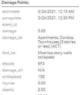
Newnan, GA upped to 170 mph EF4
-
1
-
-
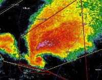
The south B'ham tornado has been upped to EF3, and with a path length of 34 miles.
-
Just now, StormChaser4Life said:
Looks like preliminary high end EF3 for Newnan
Yeah, I was referring more to the Goldville - Roanoke, AL area where I recall we had another big velocity + debris sig and PDS tornado warning.
Newnan tornado does actually remind me quite a bit of the Jefferson City, MO tornado in 2019 just by several similarities in the situations. Unfortunately seems like there was a fatality in Newnan, from a person killed by a falling tree on their home, if I remember/heard correctly.
-
Have there been any damage reports out of east-central AL from the same supercell that produced the Newnan tornado? We had some pretty bad signatures from that area last night too but haven't heard of any reports.
Severe Weather April 6th-10th 2021
in Central/Western States
Posted
NOW the HRRR wants to fire storms off in/near the Metroplex, so I guess we should watch for that. I remember hearing yesterday that the monster supercell that ended up going through Bryan/College Station didn't really start getting picked up by the models until only a couple hours before, so I'm wondering if the same thing happens again.