
WhirlingWx
-
Posts
404 -
Joined
-
Last visited
Content Type
Profiles
Blogs
Forums
American Weather
Media Demo
Store
Gallery
Posts posted by WhirlingWx
-
-
-
2 minutes ago, TexMexWx said:
Also a tornado watch issued for us in the DFW Metro. Storm in northern half of Tarrant county probably bears watching for you @Powerball and I.
FWD noting that tornado potential might be increasing with this storm as well... I'd rather not have to deal with DFW and San Antonio getting pummeled simultaneously

-
1 minute ago, Chargers09 said:
Central. Medical center area (410/10)
Hopefully the storm somehow weakens soon, but yeah I'd say prepare for some bigly hail

-
Also a tornado watch issued for us in the DFW Metro. Storm in northern half of Tarrant county probably bears watching for you @Powerball and I.
-
 1
1
-
-
Just now, Chargers09 said:
Getting nervous
Do you live in the northern or southern half of the metro? Also, this storm could produce some pretty large hail across the entire metro so if you have a vehicle outside you might wanna protect it while you can still go outside. Stay safe!
-
The outflow boundary extends well into central TX as well, and there's also a lot more instability in that vicinity compared to here it seems. Maybe we'll get a local expansion of the tornado watch if the situation warrants it later on, but things might also get squall-ish by the time storms arrive here. Still a lot of time to watch the setup evolve locally, but I think the tornado threat will maximize off to our west/southwest where the watch currently covers.
-
1
-
-
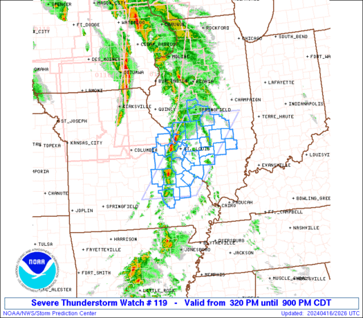
Tornado watch is up with 50/30 probabilities, does not include DFW
-
D1 Enhanced expanded eastward to include DFW, first time all year that we've been in a D1 Enhanced I believe.
-
1
-
-
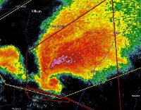
Velocity sig on that cell is going bonkers. Hopefully passes north of the small town of Truscott, and is otherwise in a rural area.
-
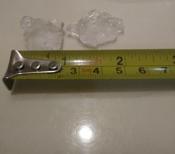
Got 1 inch-diameter hail here in the Murphy area.
-
1
-
-
Hearing a decent bit of thunder even though I'm a ways away from the storm
-
26 minutes ago, radarman said:
Apparently the balloon data showed weak winds aloft so they're saying expect disorganization til later on
Yeah now in Tarrant county it's kind of devolved into a disorganized cluster for the time being.
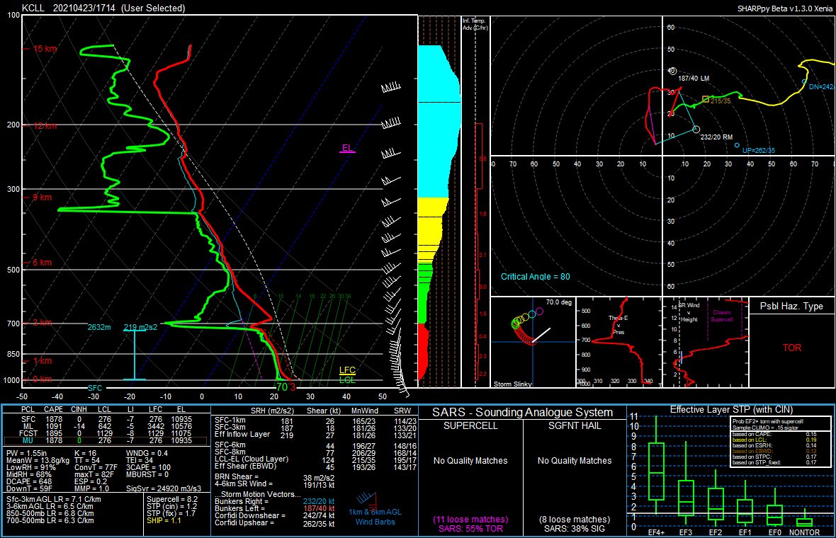
On the other hand, here is the 1715 UTC special sounding released from College Station, I believe
-
 1
1
-
-
Storm in Hood county could be a problem for Tarrant county later on if it keeps strengthening wrt hail
-
1
-
-
The discussion also mentions that an increase in tornado probabilities could be deemed necessary in the next outlook for the eastern enhanced risk area. Still yet to be determined how each threat area unfolds, obviously
-
6 minutes ago, Powerball said:
Hi-Res models have been mixed on convection coverage locally. Some go bonkers (like the 3km NAM and RGEM), and others give us the middle finger (NMMB and ARW)
Yeah, I wanted to give some meaningful model analysis, but models are still pretty inconsistent even under 24 hours out (for DFW area, specifically), so I just didn't want to bother haha
7 minutes ago, Powerball said:This time though, the cap won't be an issue. It's going to be where the best forcing and convergence sets up.
Agreed on this as well
-
41 minutes ago, Powerball said:
That said, I'm still concerned most of the widespread/organized convection will miss DFW just to the south and east.
Last year on 4/22, here in DFW we were sandwiched between the two modes, with the northern mode producing strong tornadoes along the Red River into southern OK, and the southern mode producing the long-track supercell from east/southeast TX into LA and even into MS(?), dropping sigtors along parts of its path. We ended up with a cap bust here.
Given the comparisons to that day (I am aware that nobody is necessarily calling for a repeat of that by any means), it seems like we might once again be sandwiched in that spot between the two main focuses for severe weather. Obviously that's not to say that we won't see any ourselves (we may or may not), but it does seem like we're getting caught in between two higher probability corridors again. One difference (of many) between tomorrow and 4/22/20 also lies in the surface temperatures. I remember last year, we were like in the mid-to-upper 80s, but this time around we well likely be 10+ degrees cooler.
Frankly, I could see an upgrade to enhanced by SPC, but probably for portions of eastern TX where the coverage of severe storms might warrant higher probabilities (in my opinion). Obviously would not be surprised to see storms get pretty grungy there though.
-
2
-
-
20 minutes ago, CheeselandSkies said:
Sounds like there was a destructive tornado at Palmetto, LA
Reports of 8 homes destroyed (construction quality obviously pending for rating purposes), 1 fatality, and multiple injuries from there
-
10 minutes ago, CheeselandSkies said:
Does anyone find odd the lack of any tornado watches covering a 10% hatched area on the convective outlook? Especially since they routinely issue red boxes for 5% contours.
Well, I noticed a lot of SVR watches over the 10% but a TOR watch just got issued for basically the 10% hatched area. Still also found the earlier watches a bit unusual, but given how I can really only recall one tornado actually confirmed at this point in time, I guess it was the correct decision overall. Hoping we don't have any strong tornadoes overnight given that the ingredients are still favorable over southern LA/MS where the new tornado watch just got issued, going until 7 AM.
-
2 minutes ago, MUWX said:
Large tornado on the ground in Mississippi
Yup, am just now seeing pictures from a live stream. Looks like a wedge.
-
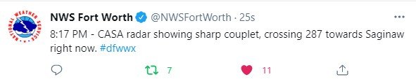
19 minutes ago, Witness Protection Program said:
That one across southeast Dallas County looked amazing from 25 miles away in far west Plano. You had to break your neck to tilt back far enough to see the tops around 7:45 tonight.
Kind of wish I had gone earlier, but took some video of lightning and storm pics for the first time about 20 minutes ago. It's not really post-worthy, but I'm just glad I was able to go out for the first time this year to see a storm.
-
1
-
-
7 minutes ago, Powerball said:
Well damn. It looks like the cap is gone too.
5K CAPE

And yeah, these other storms developing, particularly the one near Rowlett/northeastern Dallas county have given me a couple rumbles of thunder.
-
22 minutes ago, Powerball said:
It looks like another cell might be trying to develop just north of that monster cell off its outflow, which (if it does) would impact the southside of Dallas proper.
I'm gonna be watching the track of that left split, but it should pass to my southeast.
-
Wonder if the updraft will be able to sustain itself, especially with some dry air still in the lower levels of the atmosphere per the recent FWD sounding
-
7 minutes ago, cheese007 said:
What timeframe would this be?
Taking the HRRR verbatim, it would be ~6-8 PM. Anyways, the more agitated CU seems like it would pass south of you and I directly (and right as I say this the watch gets issued including us lol)
-
 1
1
-
Severe Weather April 27-28th 2021
in Central/Western States
Posted
Meso on the SA storm is weaker/broad at this time, but it could cycle again.