
WhirlingWx
-
Posts
404 -
Joined
-
Last visited
Content Type
Profiles
Blogs
Forums
American Weather
Media Demo
Store
Gallery
Posts posted by WhirlingWx
-
-
49 minutes ago, Powerball said:
00z HRRR is really ominous for DFW tomorrow evening, including a PDS Tornado sounding.
Yeah this definitely caught my attention. Just don't like how it's trending up for us and how the general threat is expected to unfold along the I-35 corridor during rush hour
-
 1
1
-
-
Yeah, kind of bummed that this isn't gonna last for too long. These are the biggest snowflakes I've ever seen, I think.

-
12 minutes ago, vwgrrc said:
Regardless, there's pretty much a consensus across the models that Collin County will get a tons ice unfortunately. That's really concerning given how populated Allen/McKinney/Frisco area is. Most of our friends are in these 3 cities and got hit hard in last year's poweroutage.
I got lucky last year to not lose power (I still don't know how exactly the grids work - I know I'm near a fire station but some people I know in a similar situation still lost power). I've been following this thread and consider me quite worried as well.
-
7 hours ago, Powerball said:
Much of the region is currently under severe to extreme drought conditions, with no relief in sight:
Strangely enough, almost unwittingly drove past a small grass fire this afternoon (east Plano). First time I've seen one personally. The grass was definitely very dry, but no clue how it started- the median in the middle of the road was just covered in flames. Definitely hadn't been going on for long, but it looked like it was fixing to jump across the road, but again I have no real experience with fires (this road was between a church and a high school right as students were leaving, so it was busy). As soon as I grabbed my phone to dial 911, a firetruck rounded the bend into my FOV and took care of it.
I guess that's just a little experience I wanted to share to which the severe drought here is relevant.
-
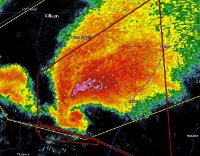
1 minute ago, Witness Protection Program said:
Today the KY gov. said the list of the missing just in Dawson Springs is 8 pages long.
Are you serious? I thought that was for all of Western KY...
-
Bowling Green area
-
-
Looks like it's hitting homes north of Fredericktown
-
Looks like a tornado near Clinton, OK (currently) as well as near Sharon Springs, KS (earlier)
-
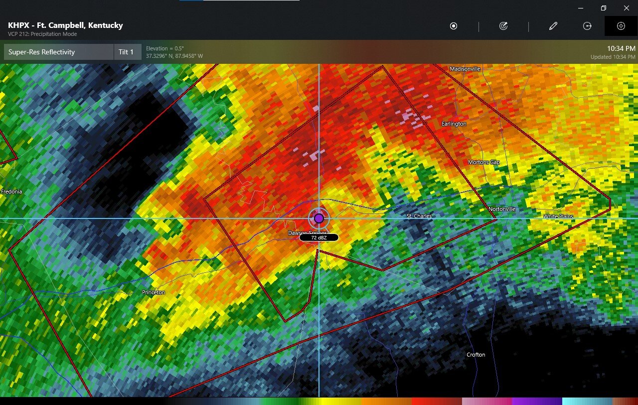
6 minutes ago, Windspeed said:
Yikes...

Pretty pronounced debris signature on that now too.
-
1
-
-
-
NW of Boise City, OK
EDIT: Seems like some chasers are convinced it was a scud bomb (either this image or other reported tornadoes in the area). Guess we'll find out later.
-
PDS warning(s) now for that storm for all of about 9 people in total + chasers
-
Just now, cheese007 said:
Incredible wall cloud. How are you finding all of these?
WxTwitter can get incredibly chaotic but it's also very helpful for finding streams (especially when people actually credit the images that they post lol)
-
1
-
-
4 minutes ago, TexMexWx said:
Livestream of tornado near Herndon
Another very rapidly rotating wall cloud on that stream simultaneous to the other tornado (which may have been weakening, but can't see because he's not pointing at it).
-
Livestream of tornado near Herndon
-
Pretty much all other CAMs show convective initiation though... We've seen multiple times where the HRRR backs off on initiating during the late morning on the day of only to just be wrong and in disagreement with the other models. Of course, storms aren't guaranteed either, but I'm just saying that this kind of situation is not too unusual for the HRRR.
-
1
-
-
Also a tornado-warned storm approaching the Lubbock metro from the west.
-
Hail-driven MOD risk including Lubbock and Abilene
-
-
54 minutes ago, Powerball said:
Oh my...
Tornado Warning
TXC113-161945-
/O.NEW.KFWD.TO.W.0019.210516T1908Z-210516T1945Z/

BULLETIN - EAS ACTIVATION REQUESTED
Tornado Warning
National Weather Service Fort Worth TX
208 PM CDT Sun May 16 2021

The National Weather Service in Fort Worth has issued a

* Tornado Warning for...
  North central Dallas County in north central Texas...
I went out to take a look, everything was rain-wrapped obviously and couldn't see anything lol, but was worth a shot
Not sure if we ever had a touchdown, but the path of the rotation would have taken it right over my old neighborhood (which also got on 10/20/19)
-

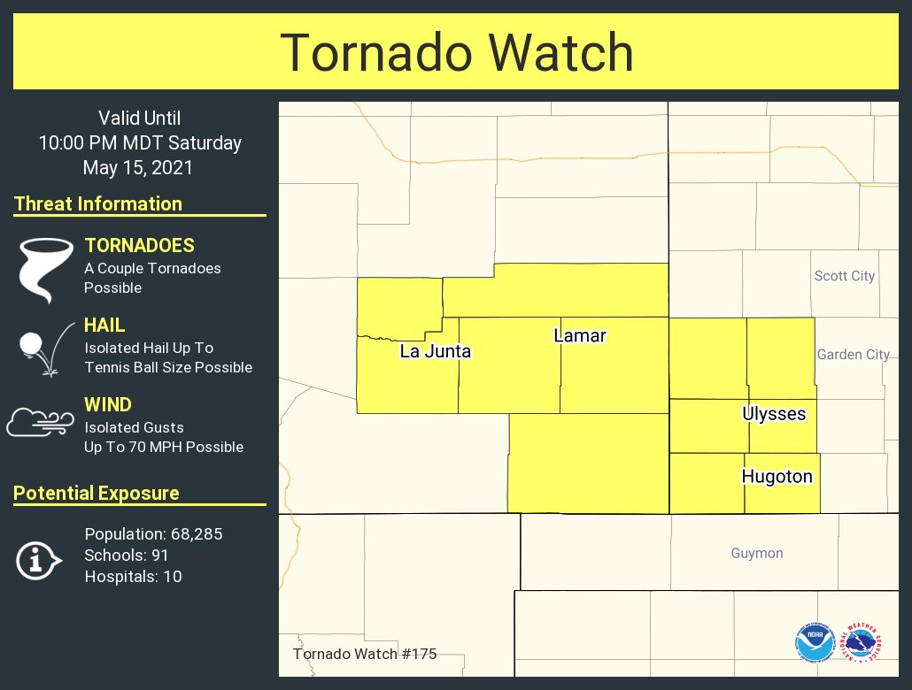
Mesoscale Discussion 0625
   NWS Storm Prediction Center Norman OK
   0617 PM CDT Sat May 15 2021

   Areas affected...southeast Colorado through southwest Kansas

   Concerning...Tornado Watch 175...

   Valid 152317Z - 160015Z

   The severe weather threat for Tornado Watch 175 continues.

   SUMMARY...A relatively small window will exist through mid evening
   for brief isolated tornadoes from a portion of southeast Colorado
   through southwest Kansas.

   DISCUSSION...Early this evening a stationary boundary extends
   through southwest Kansas into southeast Colorado. Dewpoints are
   generally in the upper 50s to around 60 F in vicinity of this
   boundary contributing to somewhat lower LCLs and up to 2000 J/kg
   MLCAPE. Storms will continue spreading eastward off the higher
   terrain, and other storms may initiate on the boundary. Effective
   bulk shear around 35 kt will promote both multicell and marginal
   supercell structures, and some increase in 0-2 km hodograph size
   will occur as the low-level jet strengthens this evening. The
   primary threat for a few brief tornadoes is expected to occur as
   storms develop along or move east and interact with the boundary
   where low-level vorticity will be maximized.

   ..Dial.. 05/15/2021
-
Interesting lol
-
Law enforcement confirmed tornado near Weldon in east/southeast TX


3/17/2022, 3/21/2022 & 3/22/2022 Severe Weather, Major Tornado Damage in New Orleans
in Central/Western States
Posted
Everything fine here as well, was completely focused on the tornado warning since it was heading straight for me too. Just some rain and thunder/lightning now