WhirlingWx
-
Posts
404 -
Joined
-
Last visited
Content Type
Profiles
Blogs
Forums
American Weather
Media Demo
Store
Gallery
Everything posted by WhirlingWx
-
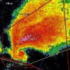
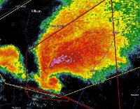
Kansas looks like it's pulling something out of its sleeve again with a TOR warning for areas in and around Salina and another northeast of there (hodos from KICT and KTWX show very sizable amounts of 0-1 km SRH in excess of 500 m2/s2)
-
FWIW, looks like there's a low-end tornado watch up downstream of the current SVR watch in parts of N/NE KS
-
Environment directly ahead of the Ellis/Kaufman cell and the line behind it isn't too bad. SRH is nothing crazy obviously and LCLs are a little high, but there's still >3500 j/kg CAPE
-
Tornado warning on that trailing storm as well. The last thing we need is another tornado to drop on the interstate with traffic backed up and EMTs on the scene
-
Jeff Piotrowski's live stream got really morbid with critically injured people on the Interstate and he's trying to not film but also trying to rescue.
-
Connor McCrorey reporting multiple semis flipped around him on I35
-
SVR on that cell now, and headed my way or perhaps passes just to my west
-
The anvil from the storm 40 miles to the west is giving me almost full cloud cover here.
-
SVR for Parker and Tarrant counties, storm motion off of the dryline is more north than east it seems (upscale growth says hi). Storm direction could change obviously, but right now, that's how it's looking.
-
That's a very thoughtful discussion by FWD. I really am hoping we dodge a bullet with any significant severe storms, but again, it's conditional days like these that have produced our most noteworthy severe weather events for the past several years. I have a ton of work to catch up on, but if I have time and the situation presents itself, there's a park within a couple miles of my house that gives me a slightly elevated perch to look off miles to the west that I could go to for a bit and see if I can view anything.
-
These southeast US 5% risks keep producing tornadoes, which frankly doesn't impact our risk much but these systems sure seem to want to drop 'em. Shear is still pretty weak here though and I don't think that's expected to change much on a large scale (obviously this is more in reference to the tornado threat in particular).
-
I just stepped outside for the first time today (lol) and it feels the soupiest it's been all year. Full sunshine too.
-
Yeah it's a conditional threat with multiple things that can work against it, but the potential is there to point it out. Plus, with as much CAPE as we are forecasted to have, weird mesoscale accidents happen.
-
You're right, now with the updated map on SPC I see that the 10% hatched is like maybe 10 miles north/northwest of me lol
-
/s
-
Woah wait a 10% sigtor countour in the latest outlook just barely northeast of here EDIT: We're in or close to being in all sig severe hazards here in the Metroplex.
-
Yeah hoping it gets back up in time lol
-
I think it's weakened and/or lifted. However, it cycled rapidly between the first unwarned couplet/cc drop and this, so any new cycles will still have it in place over a heavily populated area. I hope it's done; reflectivity is pretty messy around it now but inflow still seems to be feeding into it based on velocity.
-
The low-level scans from the airport radar(?) were looking strong. This tornado needs to go away ASAP
-
Drones have really revolutionized tornado videos from the Southeast.
-
Truscott, TX tornado got rated EF3. Consider me surprised that OUN found damage indicators to rate it as such. Damage survey is linked below. National Weather Service Text Product Display I'm assuming that the rating was based on the bent steel utility poles? EDIT: Okay, my eyes totally glossed over this segment: As it approached County Road 2610 and FM 1756 a semi truck was knocked over and a 4000 pound cattle feeder was blown about 850 feet to the north-northeast.
-
Norman probably took the biggest hit out of all these hailstorms when all is said and done.
-
Well the storm took a left turn and is making this age pretty badly. It might even pass clear north of me at this rate, with most of it being in southern Denton county and still moving northeast
-
Tornado warning just got cancelled for Tarrant county
-
The couplet would pass south of me at its current pace (but hail might still be an issue for me), and might take a similar path to the 10/20/19 storm. It doesn't appear to me that the circulation has gotten any tighter, and hopefully it stays that way.