

ADB83
-
Posts
215 -
Joined
-
Last visited
Content Type
Profiles
Blogs
Forums
American Weather
Media Demo
Store
Gallery
Everything posted by ADB83
-
The “I bring the mojo” Jan 30-Feb 1 potential winter storm
ADB83 replied to lilj4425's topic in Southeastern States
Euro and AIFS still giving a nice hit to most of North Carolina. All things being equal I’d rather have them than the GFS. . -
The “I bring the mojo” Jan 30-Feb 1 potential winter storm
ADB83 replied to lilj4425's topic in Southeastern States
Canadian looks like Euro. -
The “I bring the mojo” Jan 30-Feb 1 potential winter storm
ADB83 replied to lilj4425's topic in Southeastern States
GFS running now. Let’s see if it brings the low further west. She’s always the last to the party and might need another couple of days -
We have a favorite pattern for sure. We just need the energy not to miss north and south. I didn’t mean OR I meant AND because if this one misses, it’s going to be south haha.
-
The “I bring the mojo” Jan 30-Feb 1 potential winter storm
ADB83 replied to lilj4425's topic in Southeastern States
I don’t have access to it but apparently NextWeather 2.0 also shows storm potential. Doing this an hour after the huge snowstorm that turned into some sleet just got finished with is extra sick, which is why I love it -
Southern Crippler - Get well soon Jimbo Storm Obs
ADB83 replied to BooneWX's topic in Southeastern States
Would’ve had to take a video it’s getting dark! But you can hear it!! -
Southern Crippler - Get well soon Jimbo Storm Obs
ADB83 replied to BooneWX's topic in Southeastern States
Heavy sleet Walkertown -
Southern Crippler - Get well soon Jimbo Storm Obs
ADB83 replied to BooneWX's topic in Southeastern States
Sleeting again. Walkertown. 19 degrees -
Southern Crippler - Get well soon Jimbo Storm Obs
ADB83 replied to BooneWX's topic in Southeastern States
HRRR has given up and says “I don’t know” for the final line of moisturec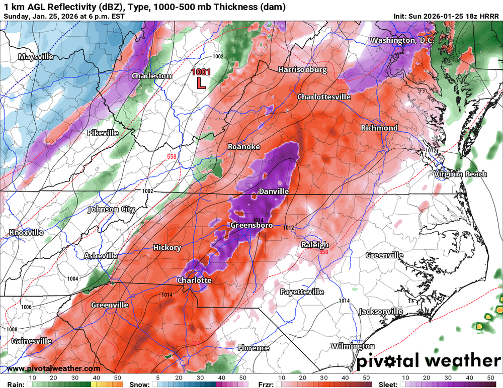
-
Southern Crippler - Get well soon Jimbo Storm Obs
ADB83 replied to BooneWX's topic in Southeastern States
It’s been said already, but the cold air is so cold at the surface that it wreaked havoc on forecasts. I wouldn’t be surprised if Winston-Salem gets some of the squall line as some pouring sleet -
Southern Crippler - Get well soon Jimbo Storm Obs
ADB83 replied to BooneWX's topic in Southeastern States
Burst of heavy sleet in Walkertown. Probably about 1.25 to 1 1/2 inches just at glance. We’ve warmed up to a sultry 16°. -
Southern Crippler - Get well soon Jimbo Storm Obs
ADB83 replied to BooneWX's topic in Southeastern States
Moderate sleet in Walkertown. 14.4/11 -
Southern Crippler - Get well soon Jimbo Storm Obs
ADB83 replied to BooneWX's topic in Southeastern States
Still sleeting in Walkertown. 19 but it feels like single digits. It’s COLD -
Southern Crippler - Get well soon Jimbo Storm Obs
ADB83 replied to BooneWX's topic in Southeastern States
Moderate sleet in Walkertown. A balmy 22 degrees -
I do think this is gonna end up doing better with the sleet versus freezing rain than the HRRR.
-
Latest HRRR is similar to previous runs, but these models are mostly sticking to this idea of some sort of freezing rain squall line coming through at least western North Carolina tomorrow evening. It looks weird and not right. Would be interesting to see if it verifies.
-
NAM much more in the sleet camp than HRRR for a much longer period of time.
-
This freezing rain squall line that has become kind of model consensus is really weird looking, if it verifies, it will be high rates at least which is actually better with ice than just the drizzle
-
NAM continuing to show the dry slot. Also has a nice little line of rain going through Raleigh at the end lol
-
They will soon. Hope everyone is ready.
-
Southern Crippler - Get well soon Jimbo Storm Obs
ADB83 replied to BooneWX's topic in Southeastern States
It is currently 41° in Winston-Salem and as warm as it’s gonna be for at least a week. Enjoy these last few hours of the 40s if you live in the Triad because you’re not gonna see them again for a while -
WFMY 2 in house model has a very brief period of snow for the Triad with around a 6 PM onset and then changeover to freezing rain at 7 AM Sunday morning. Tim Buckley sounded very sober in his 8 o’clock update. Not a tone I’ve heard a lot from him. Definitely sobers me up too thinking about the storm.
-
Feels like not so much the calm before the storm but the deep breath before the storm because I’m old enough to remember 2002 pretty well and it sucked. And I think that’s the best analog here. I also think some posters here have not emotionally recovered from the rug pull this week lol
-
I’m in Winston-Salem. I fully expect to never make it above freezing even though Raleigh might briefly and that the sleet will hold on longer than most people are forecasting. Although I do think WFMY 2 probably has a good handle on it
-
There’s been a trend for a little bit less QPF, but I think they’re also thinking maybe more sleet mixes in


