Dabuckeyes
-
Posts
271 -
Joined
-
Last visited
Content Type
Profiles
Blogs
Forums
American Weather
Media Demo
Store
Gallery
Everything posted by Dabuckeyes
-
-
Still in the game for Christmas, I suppose
-
GFS is a little sharper with the trough and slightly slower with the advancement of the cold air. Not what you want to see if you are rooting for some snowflakes on Christmas Eve night
-
The way-too-far-out snow maps show 1-2 inches of snow area wide
-
Overcast with a few random flurries. 29F with snow on the ground. Would love to repeat this for next Friday
-
I have a feeling that the CMC ( I know, I know...) is going to show a nice storm for Monday in the next few runs. It's been the strongest with the follow up wave and has been close to producing something. Seems like GFS is trying to follow those footsteps.
-
"With all the snowpack in the Northeast, the CAD signature would have to be much better than models are seeing" - Weenie Playbook 101
-
December 16-17, 2020 Winter Storm Obs/Nowcasting
Dabuckeyes replied to WxUSAF's topic in Mid Atlantic
Roads and sidewalks have caved again from sleet. Maybe some snow mixing in -
December 16-17, 2020 Winter Storm Obs/Nowcasting
Dabuckeyes replied to WxUSAF's topic in Mid Atlantic
Very heavy sleet in Lutherville -
December 16-17, 2020 Winter Storm Obs/Nowcasting
Dabuckeyes replied to WxUSAF's topic in Mid Atlantic
Sleet and ZRA mix. Temperature creeping up to 31 -
December 16-17, 2020 Winter Storm Obs/Nowcasting
Dabuckeyes replied to WxUSAF's topic in Mid Atlantic
Silver dollar pancakes are back in Lutherville. -
December 16-17, 2020 Winter Storm Obs/Nowcasting
Dabuckeyes replied to WxUSAF's topic in Mid Atlantic
Can confirm sleet snow mix in Towson -
December 16-17, 2020 Winter Storm Obs/Nowcasting
Dabuckeyes replied to WxUSAF's topic in Mid Atlantic
This has to be 2 inch per hour stuff near Towson -
December 16-17, 2020 Winter Storm Obs/Nowcasting
Dabuckeyes replied to WxUSAF's topic in Mid Atlantic
It’s thump time here. Best rates in a long time. -
December 16-17, 2020 Winter Storm Obs/Nowcasting
Dabuckeyes replied to WxUSAF's topic in Mid Atlantic
Love that low placement -
December 16-17, 2020 Winter Storm Obs/Nowcasting
Dabuckeyes replied to WxUSAF's topic in Mid Atlantic
Took the pup for a walk around the block. Went from pixie dust to moderate snow. Coating already on cars and grassy surfaces -
December 16-17, 2020 Winter Storm Obs/Nowcasting
Dabuckeyes replied to WxUSAF's topic in Mid Atlantic
First flakes in Lutherville MD -
December 16-17, 2020 Winter Storm Obs/Nowcasting
Dabuckeyes replied to WxUSAF's topic in Mid Atlantic
Haha. That's my poor 6 year old daughter sitting in the front window waiting for the snow. Good lesson in patience -
December 16-17, 2020 Winter Storm Obs/Nowcasting
Dabuckeyes replied to WxUSAF's topic in Mid Atlantic
True. My point is that you have some models keeping temperatures close to freezing and others want to have a brief warm surge. In other words...who knows what will happen. -
December 16-17, 2020 Winter Storm Obs/Nowcasting
Dabuckeyes replied to WxUSAF's topic in Mid Atlantic
GFS tried to push Baltimore up to 40F tomorrow afternoon. As many said, it really comes down to now casting tomorrow afternoon. -
December 16-17, 2020 Winter Storm Obs/Nowcasting
Dabuckeyes replied to WxUSAF's topic in Mid Atlantic
Of course this is more likely sleet than snow.

-
December 16-17, 2020 Winter Storm Obs/Nowcasting
Dabuckeyes replied to WxUSAF's topic in Mid Atlantic
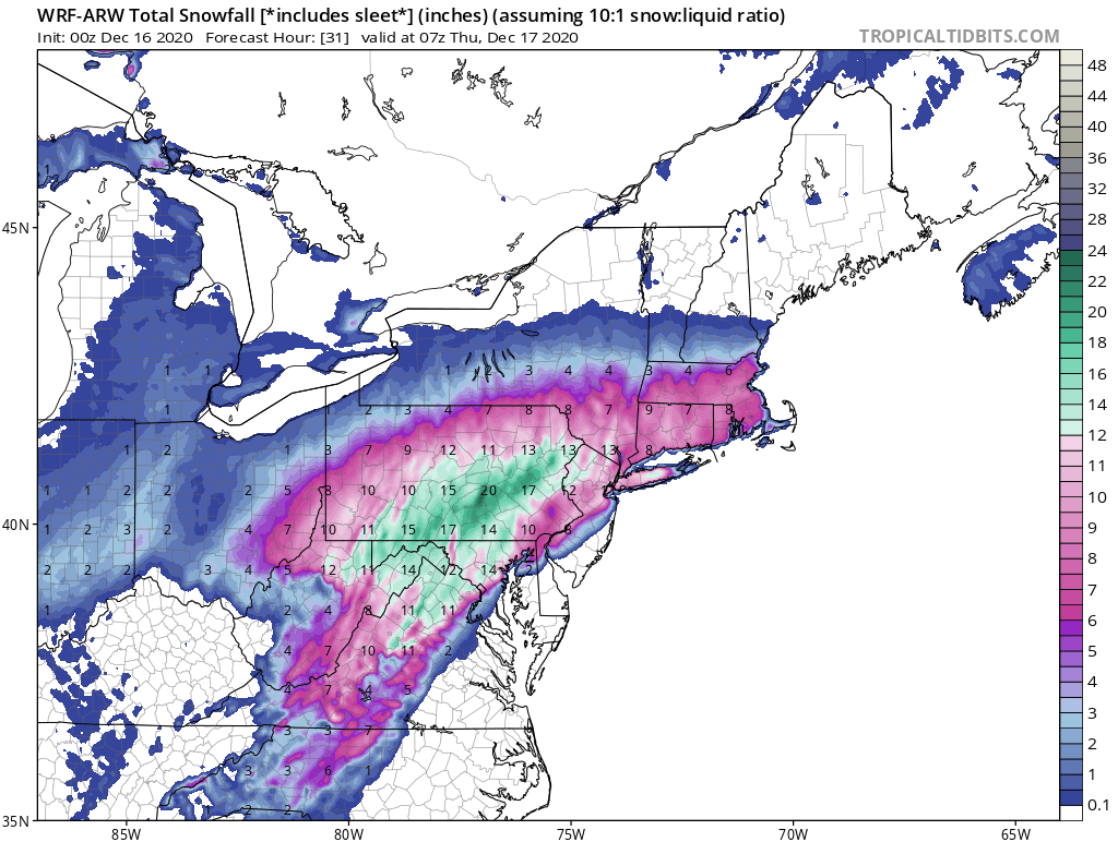
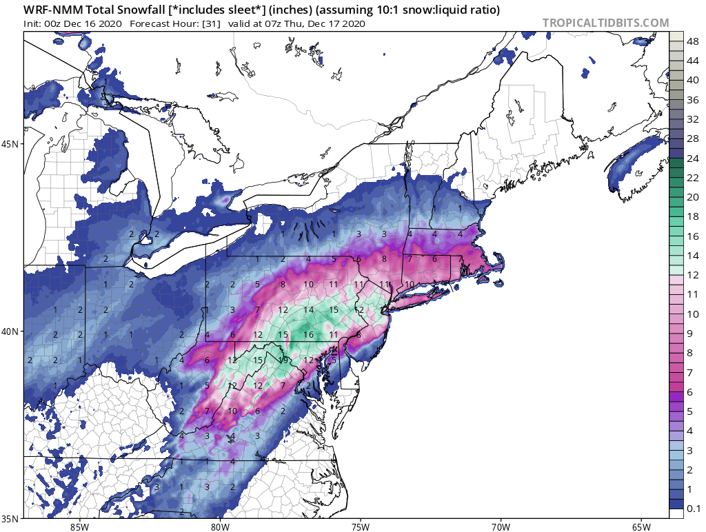
ARW and NMM please -
December 16-17, 2020 Winter Storm Obs/Nowcasting
Dabuckeyes replied to WxUSAF's topic in Mid Atlantic
I've always loved when the WWA had to be upgraded to WSW -
December 16-17, 2020 Winter Storm Obs/Nowcasting
Dabuckeyes replied to WxUSAF's topic in Mid Atlantic
I agree. As is, the 3K is snow to sleet back to snow for the Towson area. I could see a couple of inches of snow followed by 2-3 inches of sleet if that were to play out. -
December 16-17, 2020 Winter Storm Obs/Nowcasting
Dabuckeyes replied to WxUSAF's topic in Mid Atlantic
Correct me if I'm wrong, but the 3K is higher resolution. It is razor close along the fall line with surface and 850 temps. A very small adjustment would make a big difference in snow vs. sleet totals.