

Dabuckeyes
-
Posts
271 -
Joined
-
Last visited
Content Type
Profiles
Blogs
Forums
American Weather
Media Demo
Store
Gallery
Everything posted by Dabuckeyes
-
Jan 31st - 33rd Storm Obs and Disco like it's 1979
Dabuckeyes replied to Bob Chill's topic in Mid Atlantic
Yep. Visible flakes now after endless light mix most of the day -
Jan 31st - 33rd Storm Obs and Disco like it's 1979
Dabuckeyes replied to Bob Chill's topic in Mid Atlantic
Actually some light snow here just north of the beltway -
Jan 31st - 33rd Storm Obs and Disco like it's 1979
Dabuckeyes replied to Bob Chill's topic in Mid Atlantic
Looks like a light mist. If you stare you might see a mangled flake or two -
Jan 31st - 33rd Storm Obs and Disco like it's 1979
Dabuckeyes replied to Bob Chill's topic in Mid Atlantic
Just a very light wintry mix here. Some small flakes are trying to mix in but the rates are too light. -
Jan 31st - 33rd Storm Obs and Disco like it's 1979
Dabuckeyes replied to Bob Chill's topic in Mid Atlantic
Steady freezing rain/sleet mix here. Side roads are horrendous -
Jan 31st - 33rd Storm Obs and Disco like it's 1979
Dabuckeyes replied to Bob Chill's topic in Mid Atlantic
More than snow showers near Baltimore. -
Jan 31st - 33rd Storm Obs and Disco like it's 1979
Dabuckeyes replied to Bob Chill's topic in Mid Atlantic
RGEM was more tucked, but no shift with the CCB. -
Jan 31st - 33rd Storm Obs and Disco like it's 1979
Dabuckeyes replied to Bob Chill's topic in Mid Atlantic
Only has to keep those up for 12 more hours to get in the 6-12 range -
Jan 31st - 33rd Storm Obs and Disco like it's 1979
Dabuckeyes replied to Bob Chill's topic in Mid Atlantic
Steady light to occasionally moderate snow in Towson area. Would say around 3”. -
Feb Long Range Discussion (Day 3 and beyond) - MERGED
Dabuckeyes replied to WinterWxLuvr's topic in Mid Atlantic
I was worried about what to do with myself after this storm. Glad to have more to track! -
Jan 31st - 33rd Storm Obs and Disco like it's 1979
Dabuckeyes replied to Bob Chill's topic in Mid Atlantic
It’s chips fall in place time. Nice moderate snow now. -
Jan 31st - 33rd Storm Obs and Disco like it's 1979
Dabuckeyes replied to Bob Chill's topic in Mid Atlantic
Did Hershey lodge and chocolate world for my daughters birthday. Not too busy. Roads in PA were not great, MD highways are good. Nice snow falling here in Lutherville with a temp of 27 -
Jan 31st - 33rd Storm Obs and Disco like it's 1979
Dabuckeyes replied to Bob Chill's topic in Mid Atlantic
Are roads covering there? Driving back from Hershey and snow is just starting here. 83 can get sloppy fast -
I think you guys will be okay out there. Both of those models had a weird low snow hole, but that kind of stuff is not figured out this far out. As was mentioned, a stronger storm would generally yield a larger precipitation field.
-
It does. If the storm is that strong the shield would most likely be stronger as well
-
GFS bringing the goods for the area. Nice stall again. Thermals seem better too
-
Look at the next few frames. This is exactly why you need to be careful with NAM after 48. It's bouncing all over the place trying to transfer
-
Sometimes I wonder if you forget to convert mm into inches....but I like your style!
-
12z runs so far: NAM a little progressive with part 2 RGEM and ICON have the coastal stall with CCB
-
RGEM visual
-
If we can believe the RGEM (usual caveats of being out of range), it's a beautiful storm for the entire area
-
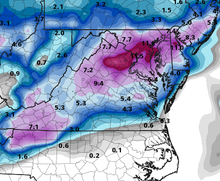
RGEM with a nice transfer and low location
-
Was going to say, ICON tried its best. Bless its heart...
-
Starts at 12z on Sunday and is still snowing at 12z on Tuesday. I'd love to see that even if it's not ripping the entire time
-
If the thermals were in line with other guidance, this would have been a huge run. Like someone from PSU said yesterday...trend


