UnitedWx
-
Posts
3,209 -
Joined
-
Last visited
Content Type
Profiles
Blogs
Forums
American Weather
Media Demo
Store
Gallery
Posts posted by UnitedWx
-
-
1 hour ago, TalcottWx said:
Need my address? Haha. Just finished shoveling..
It's a winter wonderland out here!
-
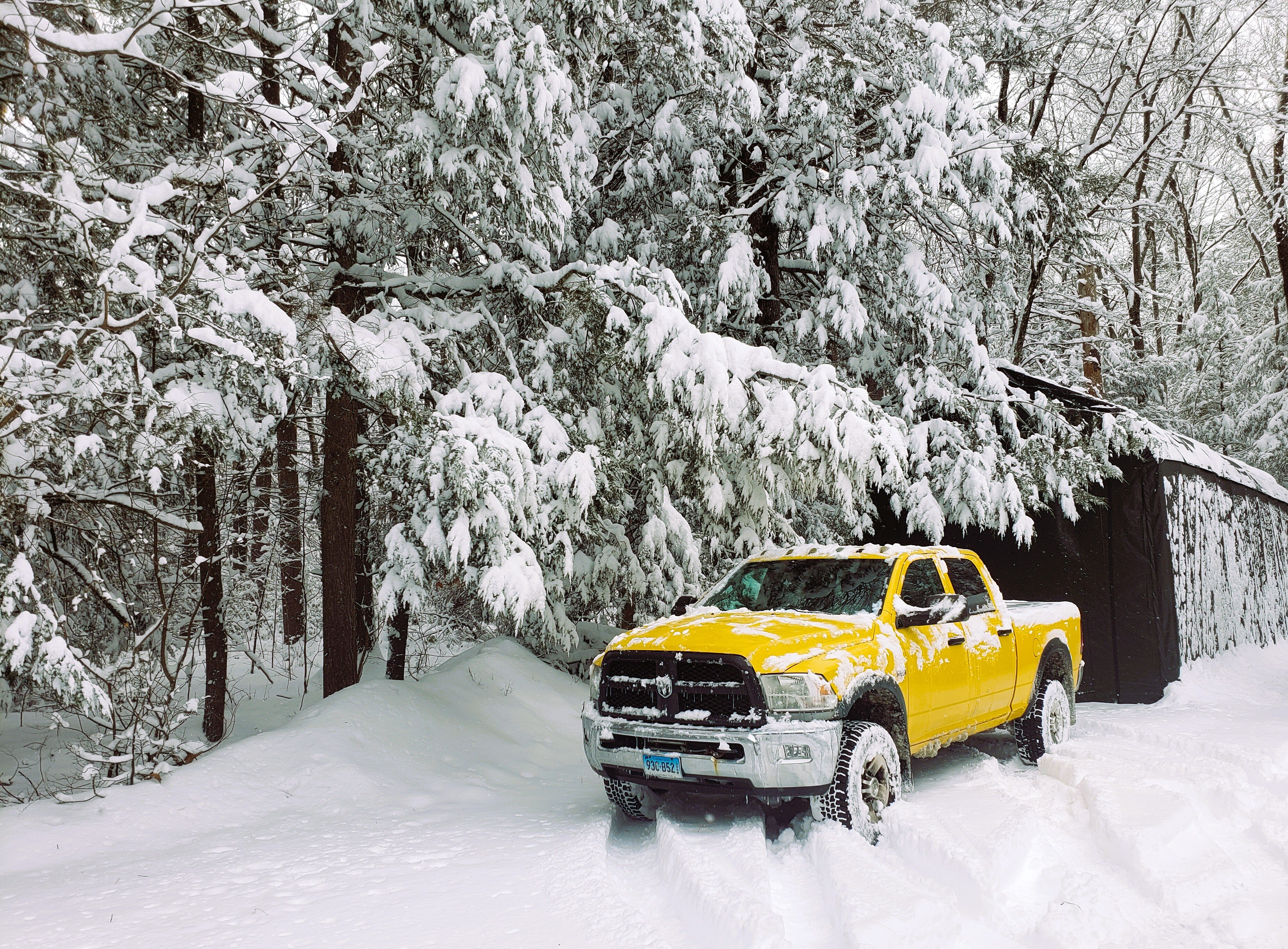
7 inches in Granby and absolutely dumping. Getting ready to hit the road and start opening driveways
-
-
Went from weenie flakes here in Westfield to moderate snow within a couple minutes. Everything is already coated up. Off to help my buddy fix his plow and do a first Pass opening driveways later
-
A few flakes have started here in Westfield, just the weenie variety for now
-
7 minutes ago, ineedsnow said:
New BOX map just issued
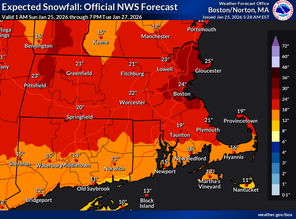
If latest modeling is correct, I bet that's updated by noon
-
 1
1
-
 2
2
-
-
18 minutes ago, Sey-Mour Snow said:
Everyone head over to the obs thread as the first flakes are minutes away from New England. Heavy snow during the day just hits different, enjoy everyone.
Gonna be fun, especially after getting a
 from Torchy
-
 2
2
-
1
-
-
23 minutes ago, WinterWolf said:
It’s gonna be 20” plus here too with that qpf that’s modeled now…we gonna rock..we ALL GONNA CRUSH. 5 degrees out there…airmass is so serious.
3 degrees here. Just had to add air to the better halfs tires. Very still out... calm before the beast!
-
1
-
-
9 minutes ago, dryslot said:
Yup, CRS disease.
Mine has progressed to C.R.A F.T. Syndrome
-
For my areas I'm thinking 12 to 18. What's nice with this system, if it comes to fruition is that it's apparently trying to spread the love in quite a large area. Love to see it
-
2
-
-
13 minutes ago, Damage In Tolland said:
Subtle undertones? Not sure what you’re insinuating. Just making a valid observation. No more , no less .
Agreed. I could be much more harsh than subtle undertones when it comes to NWS but I won't. How's that for subtle LOL
-
 1
1
-
1
-
-
7 minutes ago, tavwtby said:
yeah who knows, the text don't match the map either, we'll have a better idea tomorrow I guess, in fairness, their maps only went to Sun 7pm...and that showed probable 7", 1/10 of 13", unless it's changed by now.
Yeah, I always forget about the time range listed on their maps. I've always felt there's stormed up maps should be the entire event, and they should separate out time frames in the text
-
1
-
-
24 minutes ago, Kitz Craver said:
06z GFS with an absolute monster Miller A for Feb 1. Wow.
That would be sweet, and still active after
-
1
-
-
30 minutes ago, tavwtby said:
noticed ALY has taken the map away from the watch page, and the regional map doesn't match other offices maps, odd
Inter office
fights?? -
Don't mean to downplay the NWS (well... yes) but honestly I haven't seen them as relevant in years. Except sometimes for alerts, they're always a day late and a dollar short. Last weekend was a perfect example
-
The last time I remember a SWFE type storm was in winter 2000. I remember it because the commute from Farmington to Simsbury was near impossible in my shitconoline van. Was supposed to be a couple inches and between 11 am and 4 pm we had near 10 inches. I don't remember if there was coastal development with that one, but I don't believe so. This has so much potential, hopefully we cash in
-
1
-
-
22 minutes ago, CoastalWx said:
Ha Nam almost sleets to Kevin and me.
We knew that would likely show up at some point. NAM... see you at 12Z
-
9 minutes ago, ROOSTA said:
Just awoke,
Ensembles? Beuler
For the win someone, anyone.
Follow the coach.
Ain't nobody got time for that on this end, got to be on the job site soon. Quick synopsis everything is certainly still on track
-
1
-
-
32 minutes ago, Baroclinic Zone said:

Ha didn't even see that. There's too much going on
-
Everything already coated up here.
-
Light snow in Westfield
-
Anybody have the TPV panel for Sunday? I can't find where I was looking at it yesterday
-
4 minutes ago, Kitz Craver said:
Won’t the 850 low going west introduce dry slot issues?
If I'm remembering correctly, as long as the warm front stays Southwest of our area we should be okay
-
2
-
-
4 hours ago, ORH_wxman said:
I moved the last page of posts about Sunday/Monday to the other thread.
It’s gonna get messy in here with other storm signals showing up now for late Jan and early Feb.
Thanks. We've been in pre season form for... 7 years. Some are out of practice.

Eastern Mass Gets Their Swag Back - SWFE on Steriods - Region wide Major Snowfall - Jan 25-26, 2026 Nowcast/Obs.
in New England
Posted
14.75 in Simsbury. Wind has increased quite a bit. Visibility BLOWS! it's awesome