

NW_of_GYX
-
Posts
781 -
Joined
Content Type
Profiles
Blogs
Forums
American Weather
Media Demo
Store
Gallery
Posts posted by NW_of_GYX
-
-
GFS still printing 2.5”+ qpf for NVT spine. I think I recall a poster mentioning that model handles upslope events really well
-
Euro is out on its own right now. Tossing >4” here far and wide until I’m wiping it off my car.
-
 2
2
-
-
1 hour ago, PWMan said:
Heading to Jay this weekend. I'd planned to meet up with my twins (UVM freshmen; spring break starting) and ski Sat-Sun, but we shifted to Sun-Mon based on the forecast. I'm guessing we won't be the only people trying to get in on fresh snow.
I will be there Monday-Tuesday assuming upslope signal stays strong
-
Looks a healthy upslope signal for Mon-Tues in NVT. I think we’re cooked here but north and west of me should do OK on Sunday. Can we do 4” inches of rain in first 10 days of March in the foothills of the white mountains?
-
6 minutes ago, dryslot said:
Its there, NW Maine is where it is, You'll have to get up in the 2,500-4,000' range.
Kibby area for sure
-
1
-
-
2 minutes ago, dryslot said:
Yes, Big week for some of those areas, To bad it didn't happen 2-3 weeks ago.
I'm eager for a chase Thursday-Friday but will until 12z tomorrow to make a call.
-
1
-
-
12z gfs def more NAM like and further south. Would love to trend this into a loaf crusher.
-
8 minutes ago, dryslot said:
They will get some.
And probably more Sunday-Monday
-
NAMs are fun to look at for NNE elevated areas Thursday-Friday.
-
1 hour ago, dryslot said:
12z GFS, lolz
If there’s a way not to snow this season that will verify. Toss anything sig far and wide until it’s within 48 hrs and even then
-
3
-
-
Thursday/Friday starting to look interesting. Let’s get it inside 100hrs, haven’t been able to do that here since January
-
1
-
-
52 but feels much warmer in the sun. Killer afternoon at the hill. Love days like this

.-
5
-
-
46 minutes ago, Typhoon Tip said:
Wow, that's an ugly mid month for those into early diagnostics ... lot of moving parts to consider.
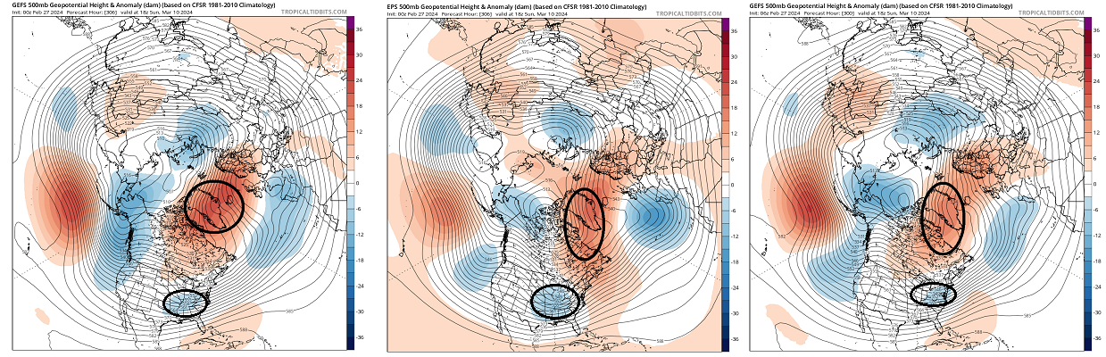
At a step back perspective, there's a clear climate precedence for post early warm episodes, to see the materialization of a -NAO. When looking at the overnight layouts from all three majors .. there's hints of that taking place, so seeing as it matches said climate precedence ...
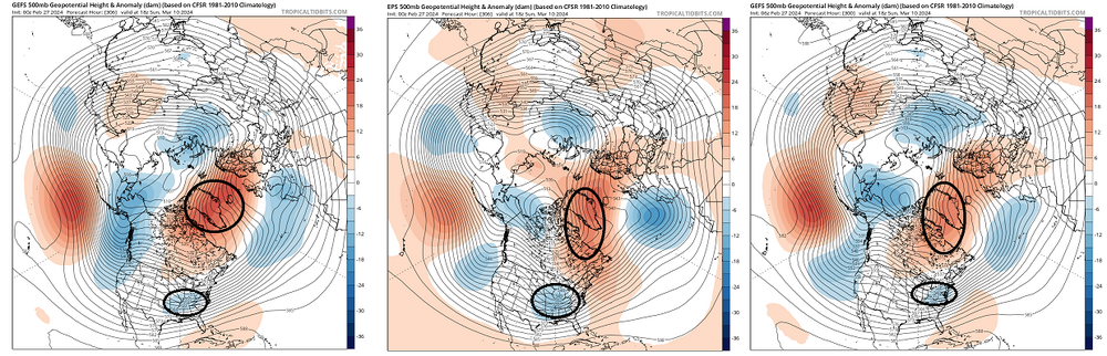
The first most obvious detraction about this outlook would be the D12 distance ... It's really beyond the "confidence horizon" at that range. However ( again ), the historical inference: said outlook fits the motif of mild to warm (relative to season, and by pattern recognition) in the foreground, evolving into -NAO. So we wait.
That trough I annotated slipping underneath is of Pacific origin. It's been gaining coherence ... despite the long range. This complicates matters ... if a more aggressive emergence of the NAO transpires ( which I believe is well within the 'realistic' probability envelope ), it could either evolve into a suppressive influence ... or something more ideal where it loads cold into Ontario but doesn't interfere ( negatively) with the wave space as it is forced S of our latitude. This latter scenario sets the stage for ...
The sun, working into an 'elastically taut' hemisphere aching for a reason to normalize gradients because of normal seasonal forcing, together with back ground ... this whole evolution above is going to be getting whacked around a bit in future guidance.
I have one eye half way open for that period.
-
1
-
-
2 minutes ago, dryslot said:
I need another 12" to tie 2015-16 which is the worse.
I don’t remember well enough and wasn’t taking records then. I just recall that December being an unbelievable torch, even torchier than this one. But maybe I’m wrong. There must have been a decent stretch in that year if you got to 50”. I just don’t remember it.
-
6 minutes ago, dryslot said:
 I spent the last 4 weeks in NW Maine where there was snow.

All time rat. Still think 15-16 was worse here though. Anyone have temp departures for DJF that year?
-
.5"
At least the skiing was good and got a cool undercast. Still snow in the woods and my yard has full pack but this week will finish off a lot of it.
I'm now at 40" on the season. Weirdly this winter still feels better than 15-16 somehow. Maybe because Nov-December was also a full on torch that year and I don't remember anything that year as good as the January stretch we had this year, which accounts for almost 75% of my snowfall to date. We had some snow in November and early December this year which probably helps to put this year just slightly above 15-16. The three seasons following 15-16 all had above average snow, we can hope for next year and beyond.
-
6
-
-
1 hour ago, Lava Rock said:
that blows.
may be our biggest snowfall of Feb

-
 1
1
-
-
12 minutes ago, ineedsnow said:
Some EPS members look good
care to share?
-
I don’t hate the 12z euro. Too far west for mby verbatim but looks so much better than the strung out mess it’s been showing the last few days
-
3
-
-
operational runs of the GFS just want nothing to do with spring after a brief warm up middle of next week. Tossed for now.
-
12z GEFS has a much more coherent cluster of lows tracking over the Cape into the GOM Friday night into Saturday morning. See if we can get the euro to follow suit
-
2
-
-
12z GFS will suck some posters back in
-
1 hour ago, CoastalWx said:
Euro looks like ass even north.
6z was actually a big improvement
-
looks like garbage. Running out of can to kick

March 2024 disco/obs
in New England
Posted
Very much sell.