ORH_wxman
-
Posts
93,092 -
Joined
-
Last visited
Content Type
Profiles
Blogs
Forums
American Weather
Media Demo
Store
Gallery
Everything posted by ORH_wxman
-
Significant Miller B Nor'easter watch, Apr 3rd-4th
ORH_wxman replied to Typhoon Tip's topic in New England
It was fun for a couple days. But we’re prob cooked unless we sink this back south 50-100mi -
Significant Miller B Nor'easter watch, Apr 3rd-4th
ORH_wxman replied to Typhoon Tip's topic in New England
Yeah it’s not surprising that is also where some laughable storm totals have occurred when the stars line up. Like 60”+ type totals every once in a while in that high terrain east side near Pinkham Notch. -
Significant Miller B Nor'easter watch, Apr 3rd-4th
ORH_wxman replied to Typhoon Tip's topic in New England
Phineas could get a 30 burger in this setup. -
Significant Miller B Nor'easter watch, Apr 3rd-4th
ORH_wxman replied to Typhoon Tip's topic in New England
The more consolidated solutions have incredible dynamics. But something like the GFS is less intriguing until you are into high terrain of NNE. You have the low trying to escape northeast too quickly early before it finally gets tugged back. -
Significant Miller B Nor'easter watch, Apr 3rd-4th
ORH_wxman replied to Typhoon Tip's topic in New England
Disjointed crap still on 18z GFS until it gets W Maine/White mountains. Not consolidated like some other guidance. -
Significant Miller B Nor'easter watch, Apr 3rd-4th
ORH_wxman replied to Typhoon Tip's topic in New England
Go back to the pre-clown map era when you have marginal temp profile….esp under 800-1000 feet 1. Look for 6 hourly QPF greater than 0.50”…preferably 0.75”+. The heavier the better, but 0.25 or 0.37 over 6 hours isn’t gonna cut it. That’s mostly white rain. 2. Look at 925 temps. Typically want -2ish or colder to avoid total slop though -1 will work if youre pounding with good snow growth aloft. If you aren’t satisfying both of those criteria, then you’re looking at something significantly under 10:1 ratios. Nocturnal timing for max precip can help a bit too, but it’s less significant than the two factors above. -
Significant Miller B Nor'easter watch, Apr 3rd-4th
ORH_wxman replied to Typhoon Tip's topic in New England
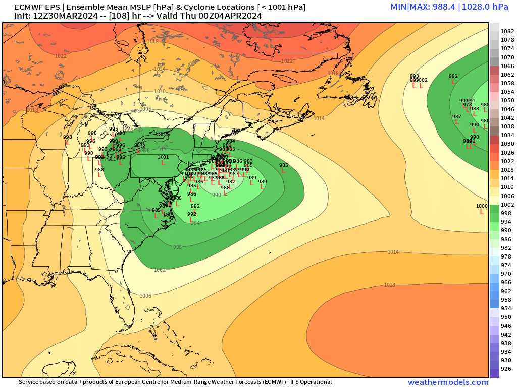
This is why consolidation matters. Keeping the system disjointed is going to make sure there’s a much stronger elevation gradient and also just lower rates in general. Even OP Euro wasn’t quite there despite the decent CCB late in the game but the EPS was better. -
Significant Miller B Nor'easter watch, Apr 3rd-4th
ORH_wxman replied to Typhoon Tip's topic in New England
Always a fear this winter. At least there’s pretty good agreement right now compared to other guidance plus that’s a pig NAO block that develops which should help hold the goalposts a little firmer. The GFS suite is kind of the outlier right now being more disjointed (though some of the GEFS did look like the foreign models, just not as many of them). If this was 3 weeks earlier, we’d have enough wiggle room that you can probably honk away right now. But this is gonna need to get closer before having any confidence. -
Significant Miller B Nor'easter watch, Apr 3rd-4th
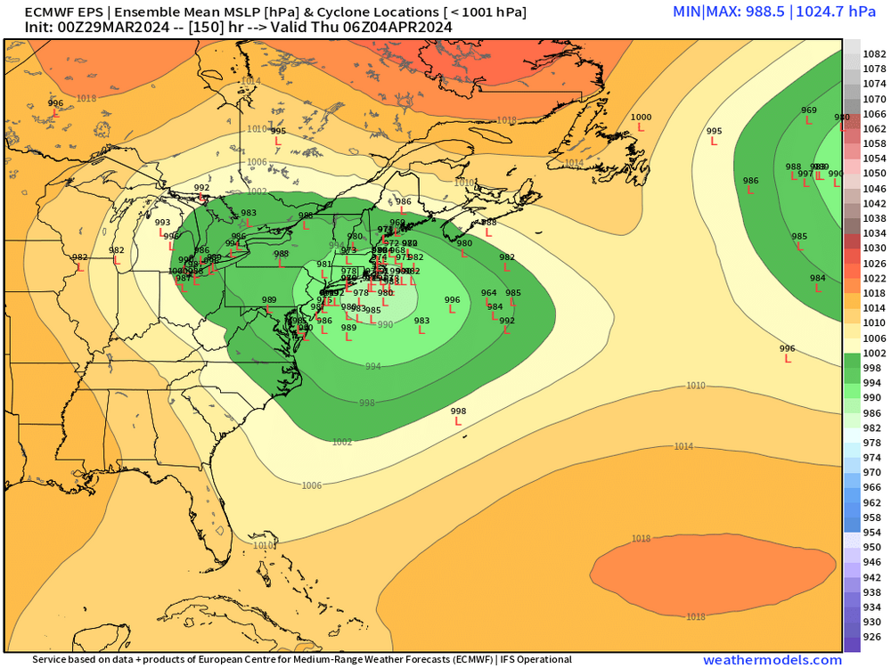
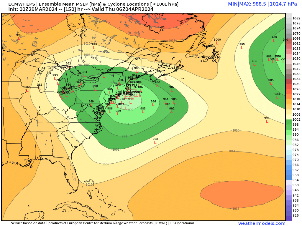
ORH_wxman replied to Typhoon Tip's topic in New England
Individual EPS. You can see how slow-moving it is. There’s also still some spread with some members trying to escape the low to the northeast before it gets captured.

-
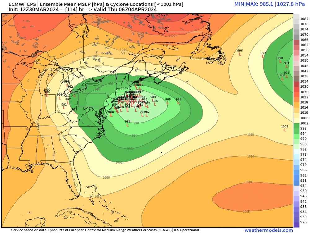
Significant Miller B Nor'easter watch, Apr 3rd-4th
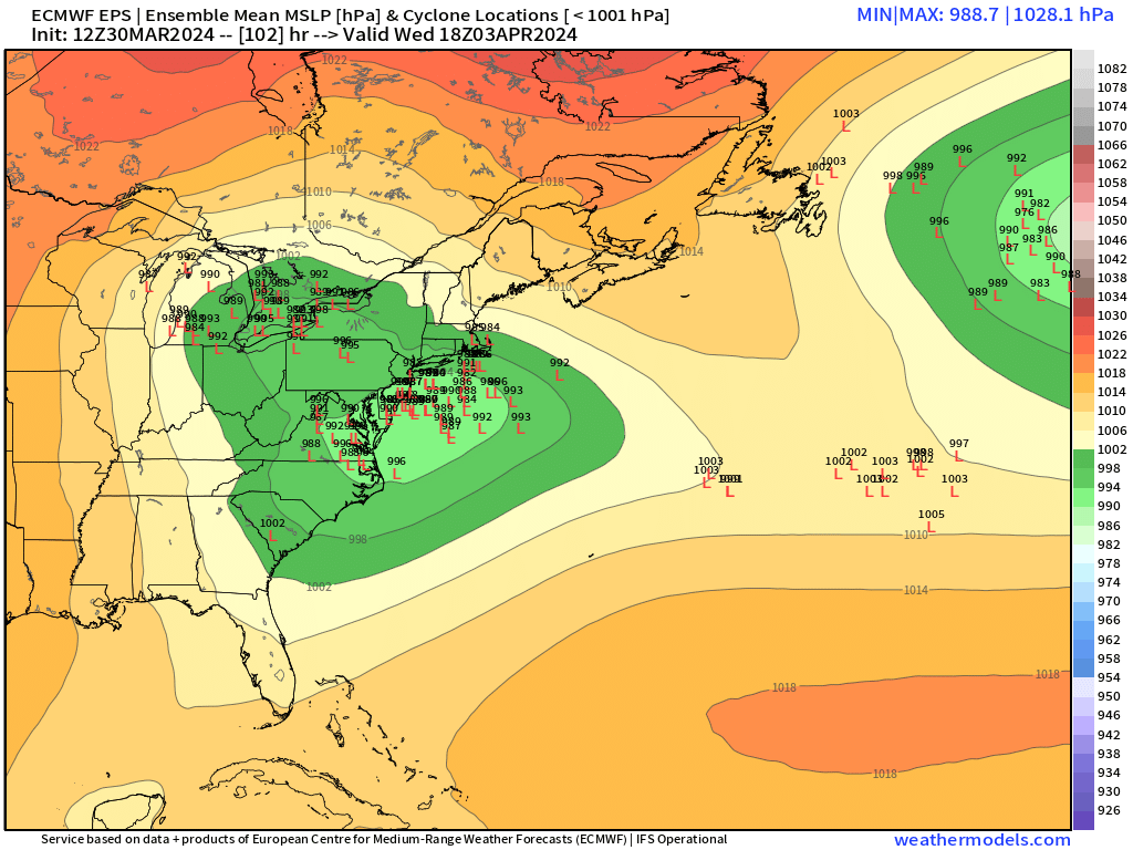
ORH_wxman replied to Typhoon Tip's topic in New England
EPS def trended better from 00z and 06z for SNE. More consolidation. I’d say that’s better for CNE too for sure. You want to avoid a disjointed system to maximize amounts. -
Significant Miller B Nor'easter watch, Apr 3rd-4th
ORH_wxman replied to Typhoon Tip's topic in New England
I’d like it another smidge south so that it stays more consolidated, but verbatim that would be poundtown for at least 6-8 hours I think right into eastern areas. -
Significant Miller B Nor'easter watch, Apr 3rd-4th
ORH_wxman replied to Typhoon Tip's topic in New England
That’s a hell of a CCB for eastern New England for a time. -
Significant Miller B Nor'easter watch, Apr 3rd-4th
ORH_wxman replied to Typhoon Tip's topic in New England
Latitude is going to help Ray. This isn’t an isothermal airmass. It’s fairly chilly aloft…esp further north. If we get a GFS solution then it’s a moot point but something a little more organized then it matters. -
Significant Miller B Nor'easter watch, Apr 3rd-4th
ORH_wxman replied to Typhoon Tip's topic in New England
He would absolutely have a meltdown if ORH up to Ray got croaked and he didn’t. It needs to be like dendrite/Monadnocks northward for him not to care much. But I’m still worried about the disjointed WAA and ULL that the GFS shows. That’s a pretty meh solution for even the snowy areas. Still a decent storm but nothing close to historic like the more consolidated looks we’ve seen. Canadian is far more consolidated and organized. -
Significant Miller B Nor'easter watch, Apr 3rd-4th
ORH_wxman replied to Typhoon Tip's topic in New England
Canadian on the other hand…. -
Significant Miller B Nor'easter watch, Apr 3rd-4th
ORH_wxman replied to Typhoon Tip's topic in New England
It’s disjointed with the WAA and the trailing ULL. These further north solutions where the WAA drives the baroclinic zone northeast cause the overall ceiling of the storm to decrease. -
Significant Miller B Nor'easter watch, Apr 3rd-4th
ORH_wxman replied to Typhoon Tip's topic in New England
NAM still really cold and south at 84h but again, really doesn’t mean anything unless the big boy models trend that way. -
Significant Miller B Nor'easter watch, Apr 3rd-4th
ORH_wxman replied to Typhoon Tip's topic in New England
I did notice the mesos were pretty suppressed. Doesn’t mean much yet though. If they still are once we get to tomorrow night then maybe. By then though, I’d expect globals to have moved some direction. -
Significant Miller B Nor'easter watch, Apr 3rd-4th
ORH_wxman replied to Typhoon Tip's topic in New England
Yeah it ruined our storm up here but you guys in CT still got crushed. That was a weird one. It trended like 100 miles south inside of 36 hours. -
Significant Miller B Nor'easter watch, Apr 3rd-4th
ORH_wxman replied to Typhoon Tip's topic in New England
It’s a subtle trend but the WAA and main coastal CCB have become a little more disjointed since yesterday. So it’s actually done two things: 1. Push the threat ever so slightly north 2. Slightly reduced the ceiling of a higher end KU type storm total max zone These are subtle trends and could easily shift back but they could also keep shifting the way they did overnight which would lessen the impact further. -
Significant Miller B Nor'easter watch, Apr 3rd-4th
ORH_wxman replied to Typhoon Tip's topic in New England
No changes. Gonna need a subtle south shift if we want to get more of SNE in the game. -
Significant Miller B Nor'easter watch, Apr 3rd-4th
ORH_wxman replied to Typhoon Tip's topic in New England
Tonight and tomorrow will be pretty big for the confidence of this storm track. Typically if you’re gonna see a big move, it’s that period from 120ish to getting inside of 100 hours. The biggest threat zone right now is prob something like western Maine foothills (like Bridgton and lakes regions there) down through dendrite-land into Monads, N ORH hills and Berks/S VT. -
Significant Miller B Nor'easter watch, Apr 3rd-4th
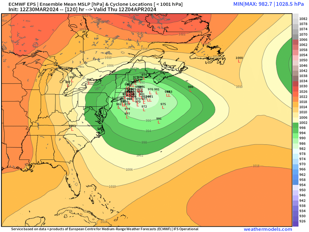
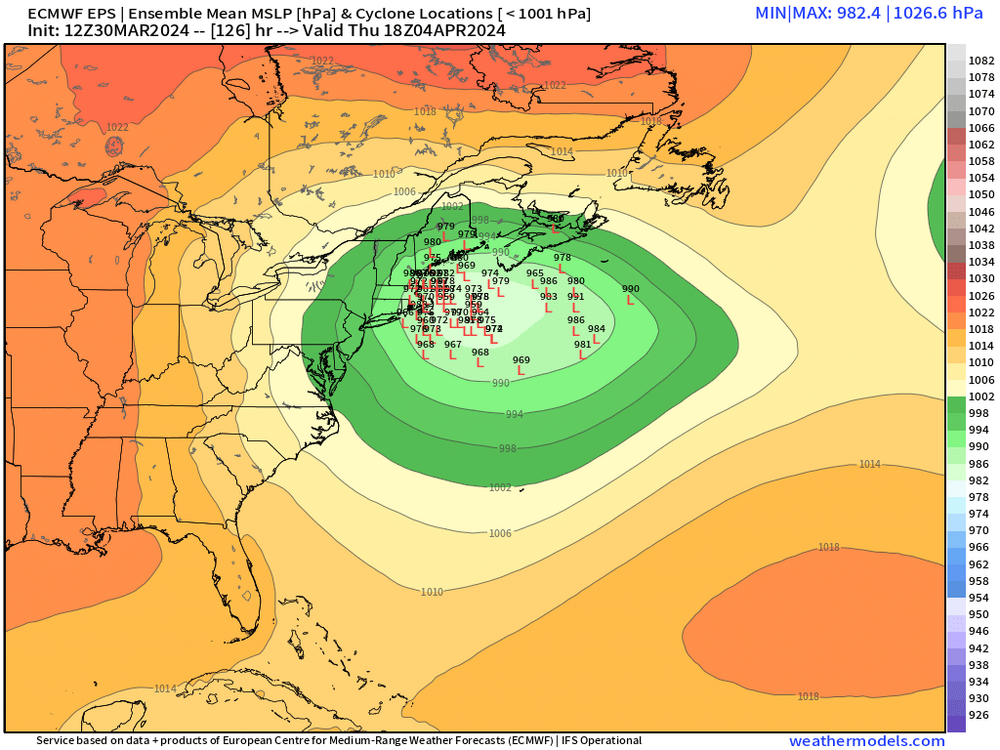
ORH_wxman replied to Typhoon Tip's topic in New England
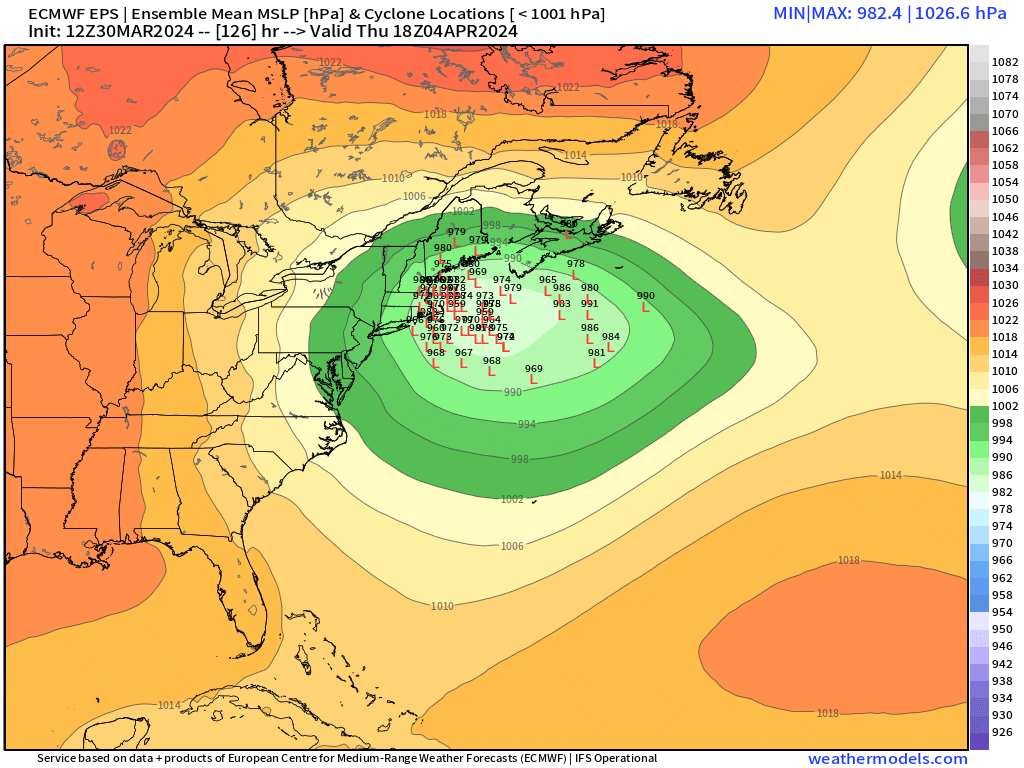
Lows are decently clustered at 126….but then they start to spray a bit like buckshot after that.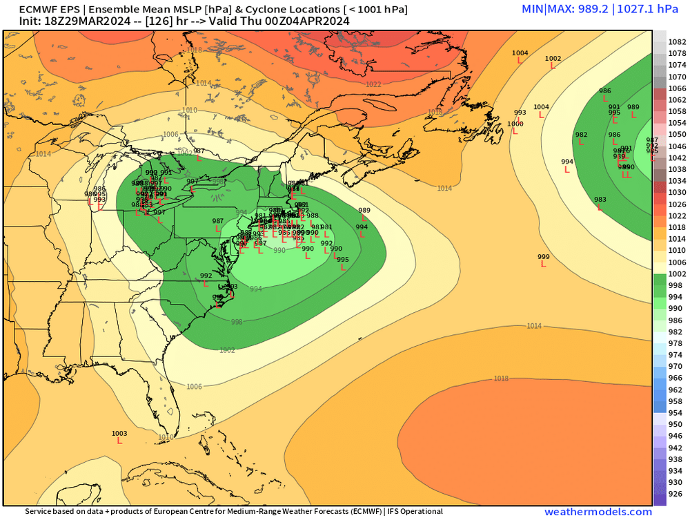
-
Significant Miller B Nor'easter watch, Apr 3rd-4th
ORH_wxman replied to Typhoon Tip's topic in New England
We’d all be worried if the Ukie was jackpotting us at this range. -
Lol…maybe if it’s still showing big snow on Saturday or easter we can take it seriously.