

Torch Tiger
-
Posts
13,279 -
Joined
-
Last visited
Content Type
Profiles
Blogs
Forums
American Weather
Media Demo
Store
Gallery
Posts posted by Torch Tiger
-
-
18 minutes ago, Damage In Tolland said:
BDL may stay AOA 80 one of those nights. This one’s shaping up to be special
Love those 90 by 9am mornings! When you can really enjoy the heat for hours and hours the entire day. LFG!
-
 1
1
-
-
6 minutes ago, HoarfrostHubb said:
I had been thinking mid to upper 80s here. Now it looks like 90-92
Yeah I suppose the speed,track etc. of the MCS/convection in the morning plays a big part in how models heat us up later
-
 1
1
-
-
1 minute ago, HoarfrostHubb said:
Sunday has trended warmer.
Has it? I thought it was advertised an 88-93 type day
-
-
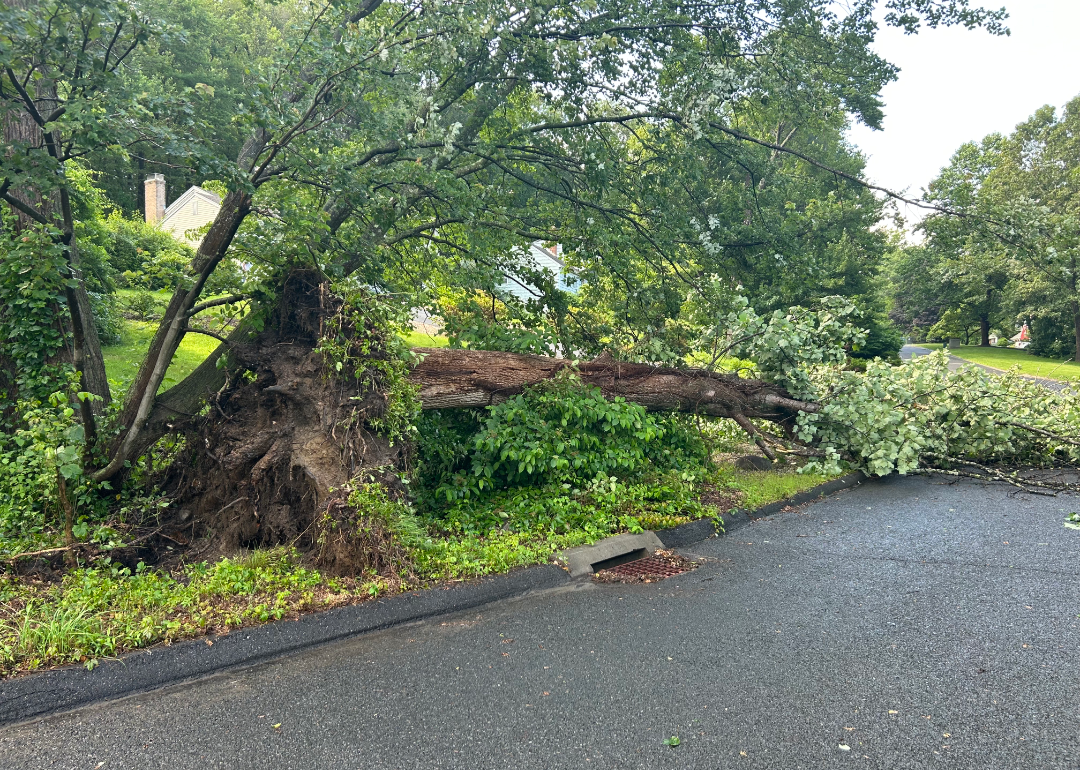
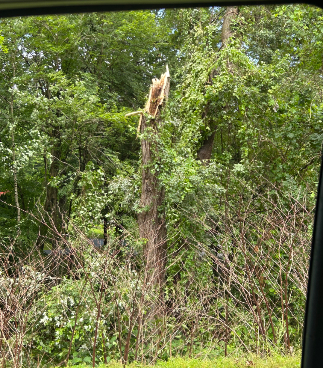
1 hour ago, FXWX said:
Burlington CT

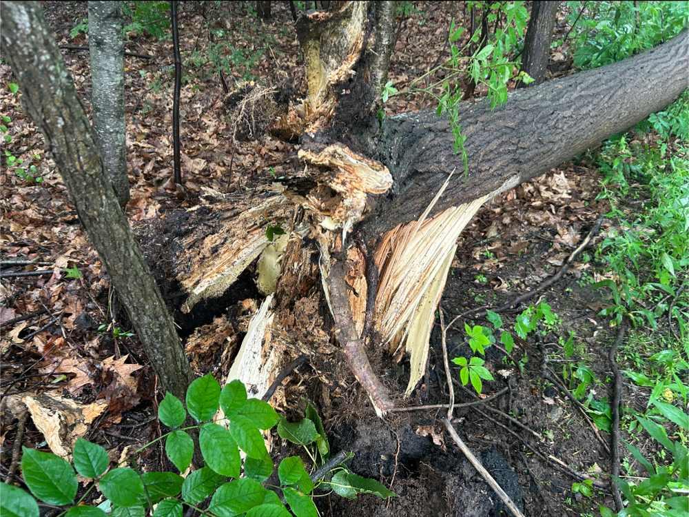
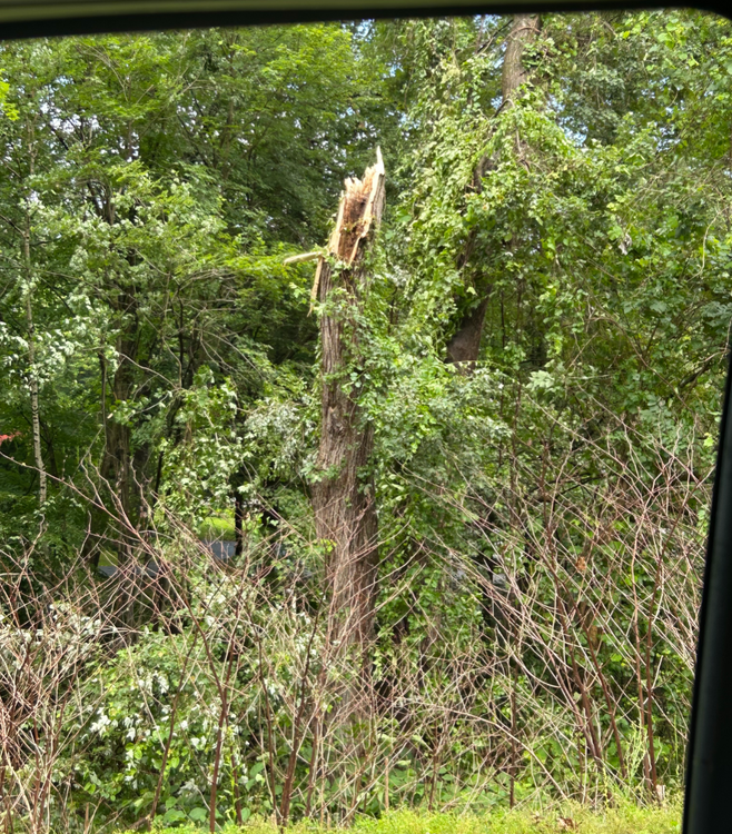
hang on branches and take them down, yea wow pushing for content there........wild damage
-
NJ/PA south every time on this thing. The organized stuff SW of "us" will rob all that energy
 Kinetics and overall environment is/are more friendly there, too.
-
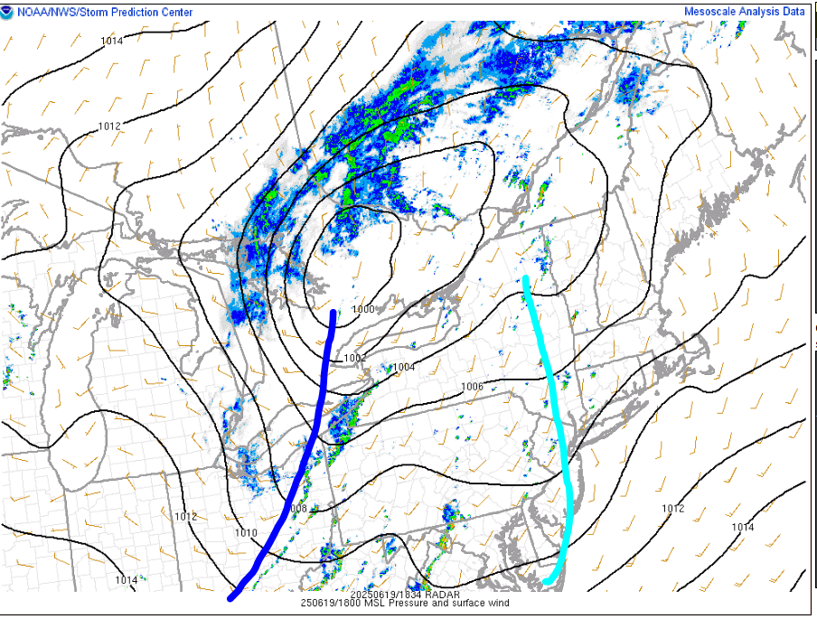
20 minutes ago, radarman said:
it's super frustrating when the 18z HRRR and the 3km initialize totally off. We already had cells in SNE at hr00 and by hour 1 both could already be tossed. It's like radar data didn't make it in.
that's true
-
11 minutes ago, weatherwiz said:
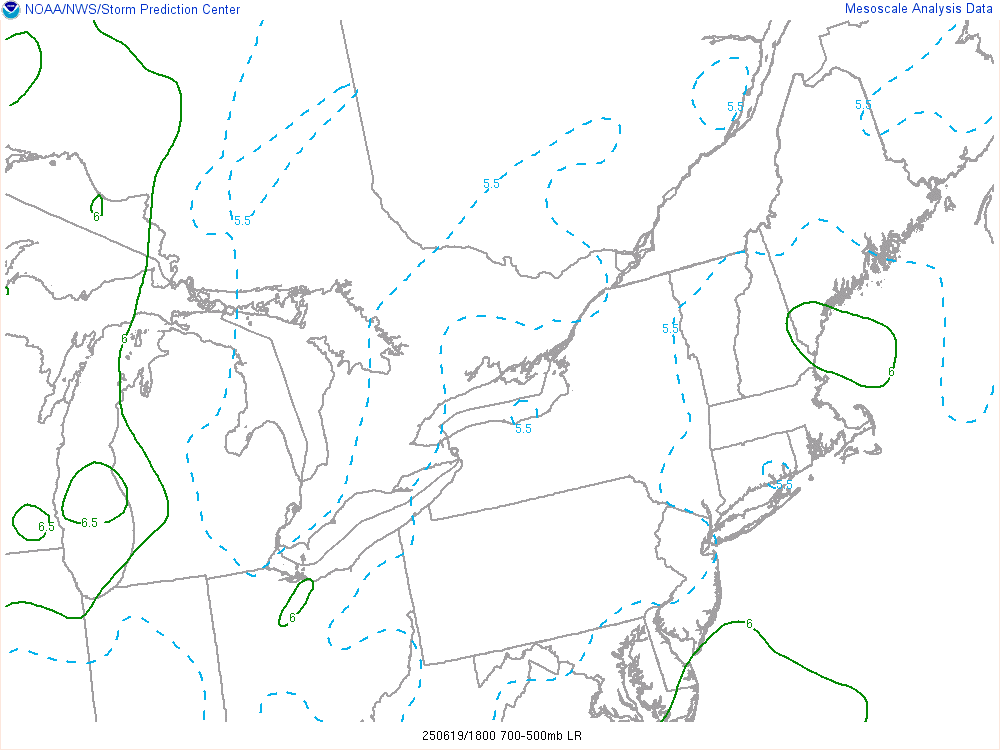
Yeah we see stuff pop more easily but the trade off is weaker activity. This is why pre-frontal troughs hurt us more often than not...once we get the convective temp reached we start popping too early. This is one reason why those EMLs are so important. they keep a lid on things until the strongest forcing can arrive
and I'm sure lapse rates aren't a huge deal TBH, 6C or 6.5C/km very doable 90/70ish. But you'd need slightly more dynamics, forcing, or shear. probably two of those three, to offset not having that bouyancy. Stronger forcing would have at least organized some of this stuff a bit more.
Not great timing at all.
-
16 minutes ago, weatherwiz said:
poor mlvl lapse rates and the forcing still too far west. I'm wondering if maybe the pre-frontal trough can stay a bit stationary if that can allow for a bit of a boost in a few hours but it probsly shunts east
Yeah, agree about those lapse rates; big-time bummer there and not sure NWS BOS or ALB discussed it at all. I was really expecting to see those dark greens? at least, 6.5 C/km or higher. Should have checked upstream soundings like you did
OTOH stuff will pop more easily, less lid? I suppose. At least there's weaker stuff :/
-
VG/VG+ job thus far from mesos, clearly hit the 19-23z for west/central. it's just too bad everything looks anemic, shallow. ":/
-
svr warning for that E NY/W MA cell.
-
10 minutes ago, weatherwiz said:
Yeah I was not pleased when I saw that this morning. Maybe the NAM was just overplaying them or maybe the convection from yesterday in the OV region just destroyed the EML plume. Could have got too much of a cold pool with the convection
hey, at least there's a few rain showers/storms around for you central and western folks. congrats
-
1
-
-
3 minutes ago, weatherwiz said:
damn I had lapse rates up on mesoanalysis and saw an area of 7 and got excited...then I realized it was 2-6km lapse rates I had up
ML lapse rates look like garbage. I get it now, ew
-
20 minutes ago, yoda said:
Watch up
Weak watch at that lol
Why is it weak?
-
9 minutes ago, dendrite said:
She’s okay. I pulled out the slip n slide for her.
read this one quick and, yikes. you did what?

-
 1
1
-
-
18 minutes ago, CoastalWx said:
Beaches were full at 10a per my wife. Yikes.
Yeah, i'm good with that mess. Usually when the beaches are jammed, I'll park at one of the road shoulders at Rye and set up shop on one of the rocks. lol
-
1 minute ago, CoastalWx said:
Beach until 4 or 5p looks like 0 chance of storms at MA beaches.
yeah I got a random day off, if it were Saturday I'd make a day of it. I was going to Rye, but if there's storms I'd have to backtrack way way west. it's a holiday, but I'd wager traffic will still be gridlock around that time

-
Just now, CoastalWx said:
Were you heading to Lake Champlain? Perfect beach weather in MA.
Yeah it's perfect
-
4 minutes ago, CoastalWx said:
Storms? LOL.
you live in S Wey, we get it
-
If that cluster of showers in S NY can perk up and move E /ENE into WNE, that would kinda support some of the east-initiating mesos
-
1 minute ago, Damage In Tolland said:
Hopefully the shut ins and recluse ACATT aren’t just sitting inside . You worry about them in these locked in HHH summers that start early and end late.
Yeah that's not healthy for the mind nor body. A few A/C days here and there okay but weeks at a time, no bueno
-
 1
1
-
-
7 minutes ago, Damage In Tolland said:
Man do we love summer . Best time of the year is here. This is fantastic . Finally locked in
Yeah it's furnaced out there, fiery. Gotta get out and acclimated.
-
skipped the beach today once I saw those damn mesos popping some storms west of here. Maybe go for a ride a bit later if there's a surviving storm around
-
 1
1
-
 1
1
-
-
44 minutes ago, radarman said:
decent line through most of CT and W MA mainly south of the pike before falling apart ORH->east
It could be overdone, but it's something
W MA- ORH -SE NH 19-23z seems to have some activity on most of the mesos.

June 2025 Obs/Disco
in New England
Posted
Love that feeling when you walk out the door and it feels like exiting FLL airport! Just hits you like a wall, no escape