

Torch Tiger
-
Posts
13,416 -
Joined
-
Last visited
Content Type
Profiles
Blogs
Forums
American Weather
Media Demo
Store
Gallery
Posts posted by Torch Tiger
-
-
1 minute ago, ineedsnow said:
Where is it 95 to 100?
Dendy just posted it
-
HI's 95-100 is a dead-on heat advisory

-
 1
1
-
 1
1
-
 1
1
-
-
Gorgeous out there, near-perfect
-
Not bad outside at all, looking forward to tomorrow!
-
1
-
-
-
-
Nice smoke/haze. Lowell nasty;D
-
One of the worst 4ths in a while, but the weekend looks decent.
-
1
-
 1
1
-
-
I am wearing 3 layers right now, long pants and hiking apparel basically. Mosquitoes are vicious
-
1
-
-
21 minutes ago, ineedsnow said:
Well atleast top 5.. if not meh
Top 20 is memorable to me, given it's the hottest time of year.
-
1
-
 1
1
-
-
2 hours ago, ineedsnow said:
you said it would be memorable so you kind of did
memorable = hottest July ever. got it
-
 1
1
-
-
18 minutes ago, RUNNAWAYICEBERG said:
We fart out AN months now, duh. The point still stands…it won’t be an all time hottest month or top 5er.
we are also farting out top 5's, you're making my point. :/
-
1 hour ago, ineedsnow said:
Not top 5 in my opinion like some are saying
29 minutes ago, kdxken said:A degree or two above old time norms isn't getting you in any record books.
15 minutes ago, RUNNAWAYICEBERG said:Over the top warmth isnt going to get you your record ass sweat. Need heights building from sw, tenn valley.
21 minutes ago, RUNNAWAYICEBERG said:These clowns lol.
Reading comprehension; I never said anything about a record hot July besides I hope we have one
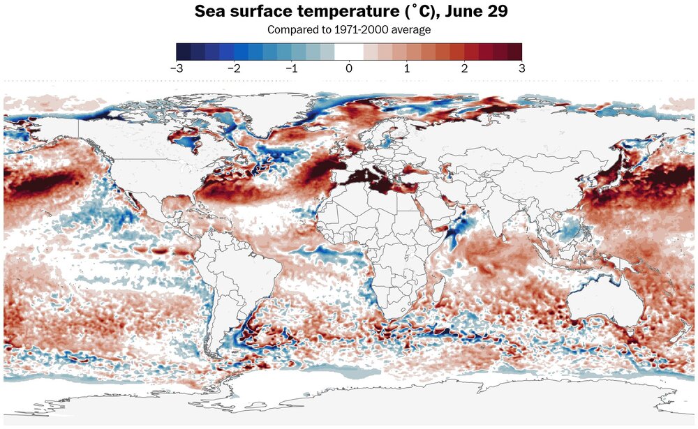
Yet last summer was one of the hottest on record for SNE, and they seem to be growing on trees as of late. Then this general SST configuration/look, plus (fading?) Nina, I'd hedge AN July with a fair shot at top 10'er, or slight top 5'er
-
1
-
-
18 minutes ago, Damage In Tolland said:
You didn’t even look. Just regurgitating what Cranky says in tweets
the two dummies Morgarbage and Cranky, can't make it up
-
4 minutes ago, kdxken said:
A degree or two above old time norms isn't getting you in any record books.
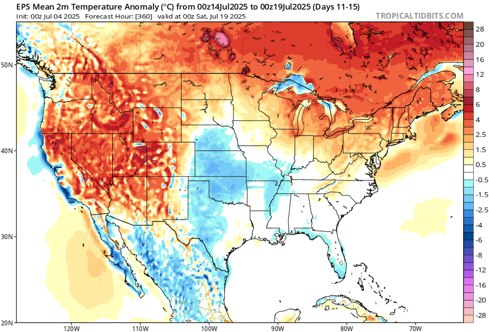
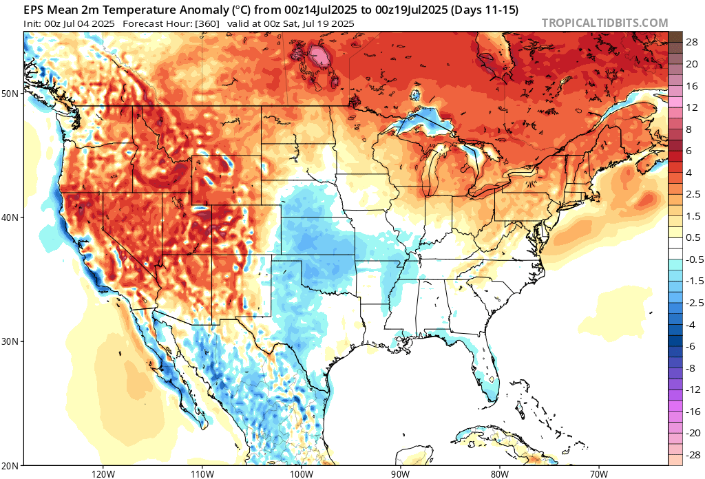
on a smoothed ensemble mean, that's damn warm. 1.5-3C
who knows, the 6z ops are actually fairly cool. no one knows
-
Yeah doesn't look hot at all. Comfy, cool

-
1
-
1
-
-
3 minutes ago, Damage In Tolland said:
Will be top 3 hottest Julorch we’ve ever seen
Yeah it's going to be memorable, hopefully #1 but top 5 works!
-
EPS and GEFS look quite warm/hot in the extended. Even +/- normal is hot, but they are furnaced D10-14
-
 1
1
-
-
Nice purple-hued sunset !
-
Should be a decent early 4th of July fireworks show as the sun sets..
-
Cape Cod will get slammed, of course
-
15 minutes ago, weatherwiz said:
pretty good storm
-
1
-
 1
1
-
-
Hopefully ginx gets a tor
-


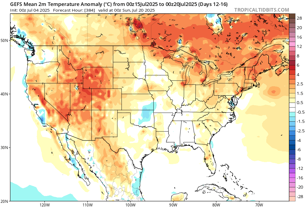
July 2025 Obs/Disco ... possible historic month for heat
in New England
Posted
all-nighters and just kept drinking. Wild