RocketWX
-
Posts
74 -
Joined
-
Last visited
Content Type
Profiles
Blogs
Forums
American Weather
Media Demo
Store
Gallery
Everything posted by RocketWX
-
MO/KS/AR/OK 2025-2026 Winter Discussion
RocketWX replied to stormdragonwx's topic in Central/Western States
Ended up with about 6" at my house. That might have been the slowest, steadiest snow I can recall, that eventually accumulated to that amount. Made for a relaxing weekend watching and tracking. Glad we could squeeze out some moisture in the plains. -
MO/KS/AR/OK 2025-2026 Winter Discussion
RocketWX replied to stormdragonwx's topic in Central/Western States
Agreed. Radar is also showing probably the healthiest band of snow up to this point, for the majority of the Wichita area moving in now, when just yesterday it looked completely dry on the models at this time. The first wave absolutely was underwhelming, but maybe we get lucky on round 2. -
MO/KS/AR/OK 2025-2026 Winter Discussion
RocketWX replied to stormdragonwx's topic in Central/Western States
Update: They already posted it. They definitely call out that the main axis of snowfall has shifted south and east for Saturday night. Now calling for 5-8" for SC KS with Southeast KS approaching 10". Of note 4-6" of that is with the first wave, so they're leaning toward the 2nd wave having minimal impact here. I'll take it, but feels like we'll just miss out on the real fun that south and east of here will get. -
MO/KS/AR/OK 2025-2026 Winter Discussion
RocketWX replied to stormdragonwx's topic in Central/Western States
I'll be very curious to read ICT's afternoon Forecast Discussion and their thoughts on the 2nd system and it's potential impact on this area. -
MO/KS/AR/OK 2025-2026 Winter Discussion
RocketWX replied to stormdragonwx's topic in Central/Western States
Just an update on Temps...my weather station is currently showing 10.2 degrees. Seems to be running a few degrees colder than HRRR -
MO/KS/AR/OK 2025-2026 Winter Discussion
RocketWX replied to stormdragonwx's topic in Central/Western States
Round 1 may be getting an early start with snow already being reported in Central KS. -
MO/KS/AR/OK 2025-2026 Winter Discussion
RocketWX replied to stormdragonwx's topic in Central/Western States
This was my concern for us. Getting in on the first wave but missing the second. Needed both to get the big totals. -
MO/KS/AR/OK 2025-2026 Winter Discussion
RocketWX replied to stormdragonwx's topic in Central/Western States
My main concern (possible failure mode) here in Wichita, is how these two waves impact us. The first piece of energy kicks out Friday night and will initially need to saturate dry air. How long does that take and how impactful is this initial wave? Should we underperform, that leaves us with the 2nd wave, (the ejection of the main ULL) which could miss us to the South and East. By failure mode I mean, failing to hit the upper echelon of some of modeled totals. Think we're in for a solid Warning criteria snow regardless. Getting closer to kicking this thing off! -
MO/KS/AR/OK 2025-2026 Winter Discussion
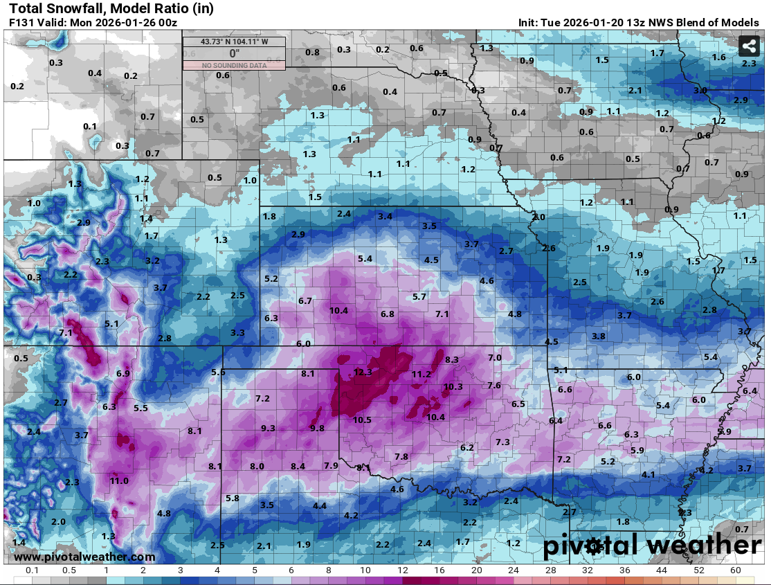
RocketWX replied to stormdragonwx's topic in Central/Western States
Here is the latest NBM run. Still throwing out hefty totals for pretty much everyone here. Not shocking since models have yet to back down on totals.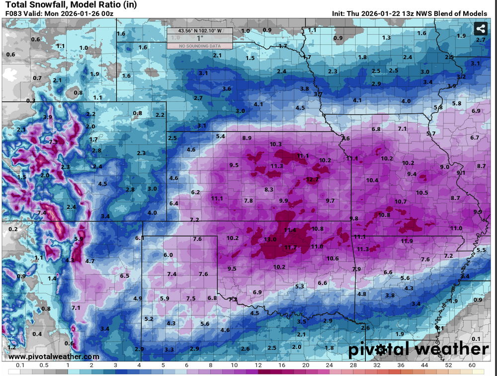
-
MO/KS/AR/OK 2025-2026 Winter Discussion
RocketWX replied to stormdragonwx's topic in Central/Western States
Yeah, I just saw that 18z ICON run. If nothing else, this storm has provided some hall of fame worthy model runs and we're within 48hrs of it getting started. Excited to see how this shakes out. -
MO/KS/AR/OK 2025-2026 Winter Discussion
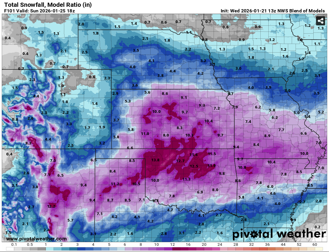
RocketWX replied to stormdragonwx's topic in Central/Western States
Here is the latest NBM, compared to 24 hours ago. Definitely a noticeable northward shift in extent of heavier totals. It hasn't necessarily backed off on the Oklahoma side either, but rather just a larger swath of heavier precip among the models. I'm definitely feeling more optimistic about a meaningful snow in SC KS than I was 24-48hrs ago.
-
MO/KS/AR/OK 2025-2026 Winter Discussion
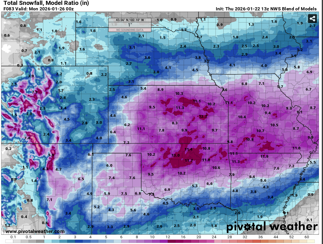
RocketWX replied to stormdragonwx's topic in Central/Western States
Here is the most recent run of NWS Blend of Models through Sunday evening. I haven't done a ton of research on it, but essentially it combines multiple numerical weather models and post processed data in hopes of giving an accurate and reliable starting point for NWS forecasts. I will say this most recent run is the most bullish with amounts across the board so far. Previous runs had ICT in the 3-5" range. This is probably due to a few factors. Models becoming more aligned as we go (confidence) and/or trends in the models. I'd still expect some fluctuations as we progress through the week, but I'd expect them to become smaller by the day. I'll be curious how this does as I don't have much history with it.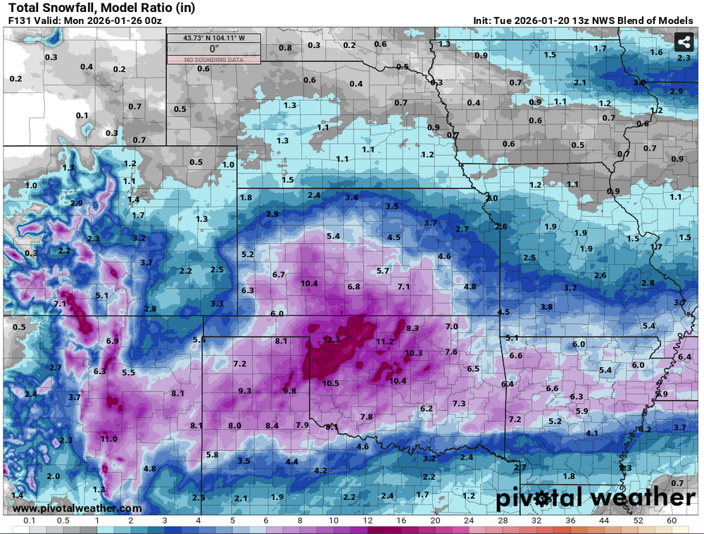
-
MO/KS/AR/OK 2025-2026 Winter Discussion
RocketWX replied to stormdragonwx's topic in Central/Western States
Well I think this is my first post of the winter season but we finally have a storm to track. Here in SC KS, I'm keeping my expectations tempered for now. While the bitter cold air is for certain, the amount of precip we can squeeze out will be the question. With fresh polar air flowing in, I'm sure we'll be battling dry air for awhile. Won't take much QPF though, as snow:liquid ratios will be quite high here. The ECMWF, GDPS and finally ICON seem to be trending positively for us locally, with GFS still the outlier but signs of it slowly following suit. Hoping for a few inches of snow at least. As mentioned, still a good amount of possibilities with this one. -
Well it looks like all eyes on Tuesday at this point. Potential for extremely cold temperatures accompanied with precipitation. Combined with high snow ratios is leading to some robust snow totals on the models. We'll see how this trends as we get closer. Euro, ICON and Canadian models seem to have same idea with GFS differing a bit depending on run.
-
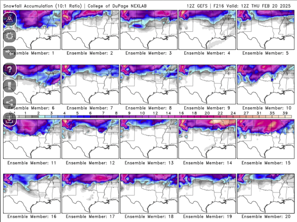
Going to be an interesting week coming up for many around here. We have the system tomorrow, one to watch Saturday and then another next Tuesday/Wednesday. How these upper level waves eject out of the west are critical in if these produce anything. Models seem to be flip flopping from run to run from positive/sheared, to holding together with a somewhat of a neutral tilt which leads to meaningful precip. The GEFS ensembles through next Thursday morning show the myriad of possibilities based on this morning's 12Z run. This would be all 3 systems combined. Should at least be fun to track. Side note: The temperature swing from this Thursday morning to Friday afternoon is pretty wild. Some big time WAA with those gusty southerlies.
-
I think I saw Wichita officially received 5.9" at the airport. I'm sure amounts vary quite a bit the with the banding nature of this snow. Looks to be about 5" of new snow at my house on the southeast side of Wichita. What an exciting storm considering it looked like we were on the fringe with 1-2" initially forecast. Hi-Res models started picking up on the heavy band of snow over SC Kansas and boy did it come through. Happy to see many others were able to cash in as well!
-
Thanks for starting a new thread! As you mentioned, been a beautiful start to Fall with warm temperatures and welcome rain that is putting a dent in the drought here in SC Kansas. Another wet storm appears likely late Sunday night into Monday with potentially multiple inches of rain! What happens after that is interesting as the first cold air of the season looks possible. I'm even starting to see some fantasy winter storms show up on models. Not concerned with that, but fun to see the season transition. Further, I am liking this wet pattern thus far! If we can keep these systems traversing the plains through winter...could be fun!
-
A couple things that have stood out to me for a few days with Saturday that separates it a bit from previous systems, is the trough ejection timing and moisture quality/depth. Today's system is really priming the pump for Saturday. More than anything though is the trough ejection timing. You have a jet streak nosing in, intersecting a dryline during peak diurnal heating, rather than late at night or early morning. The big fly in the ointment as it stands now for me is early convection moving up from the south, wiping out the warm sector. Having said that, I do feel this day has the highest ceiling I've seen in some time for OK/KS, based simply on trough timing and moisture quality alone. Seeing as this is on a Saturday and in prime location, whew boy, chaser convergence is sure to be crazy!
-
Ahh yes, the entire 240hr 12Z Euro looking nice and dry over KS. Along with some tight pressure gradients throughout, I can't wait for the forecast to be centered around elevated fire danger. sigh. This is actually right on time for peak wildfire season but really don't want to break the momentum we've built over the winter busting this drought.
-
Well I hope everyone has enjoyed the fake spring over the past few weeks. Looks like we'll have another week or so of mild temps before the pattern begins to change. Models are starting to more consistently show a system traversing the plains this coming Saturday/Sunday, 2/10-2/11. Still lots of variability in strength and location, anywhere from Oklahoma to Nebraska. However, I think there is some merit to a fairly decent storm system as the AO index appears to be crashing negative during this timeframe. This may allow for some cold air to work with and a potentially robust system. I haven't looked far beyond this timeframe but if AO remains negative the 2nd half of Feb could lend additional opportunities for winter weather. If anything, maybe some systems to track to keep us occupied.
-
Well although we've had snow here in SC Kansas this winter, I'd be lying if I wasn't a bit disappointed after missing multiple waves of snow at my house throughout this cold snap. I'm not a fan of bone chilling cold temps with no snow but that's what happened. Win some, lose some I suppose. On to the next.

-
Well, while it wasn't a blockbuster snow, it certainly provided more excitement than I thought after giving up hope of getting more than a trace to 1" 24 hours prior to. The storm tracked south of guidance and provided another 3-4" snow with lots of wind. It also flash froze all the prior standing water and slush once that that front moved through. I'm happy I got something out of this because I'm not thrilled on trends for late week storm at the moment. I can't complain with two 3" snows within 5 days. Side note: The Chiefs playoff game looks to be brutally cold. Yikes.
-
I'm not sure. I think blizzard criteria will be met at times but maybe we don't hit the duration needed? The videos from the blizzard in western Kansas have been intense!
-
Winter Storm Warning has been extended down to Sedgwick County including wichita. 2-4" with wind gusts over 50mph at times in the morning. Schools cancelling quickly now.
-
Going to very curious to see the final totals for this storm. Everytime I look at trends it seems be ever so slightly deeper and south when it comes to the ULL. 24 hrs ago I thought I may not get an inch here in Wichita and now I could see areas very near Wichita waking up to a decent snow. Combined with the winds could be a huge mess.