cyclogenesis
-
Posts
53 -
Joined
-
Last visited
Content Type
Profiles
Blogs
Forums
American Weather
Media Demo
Store
Gallery
Everything posted by cyclogenesis
-
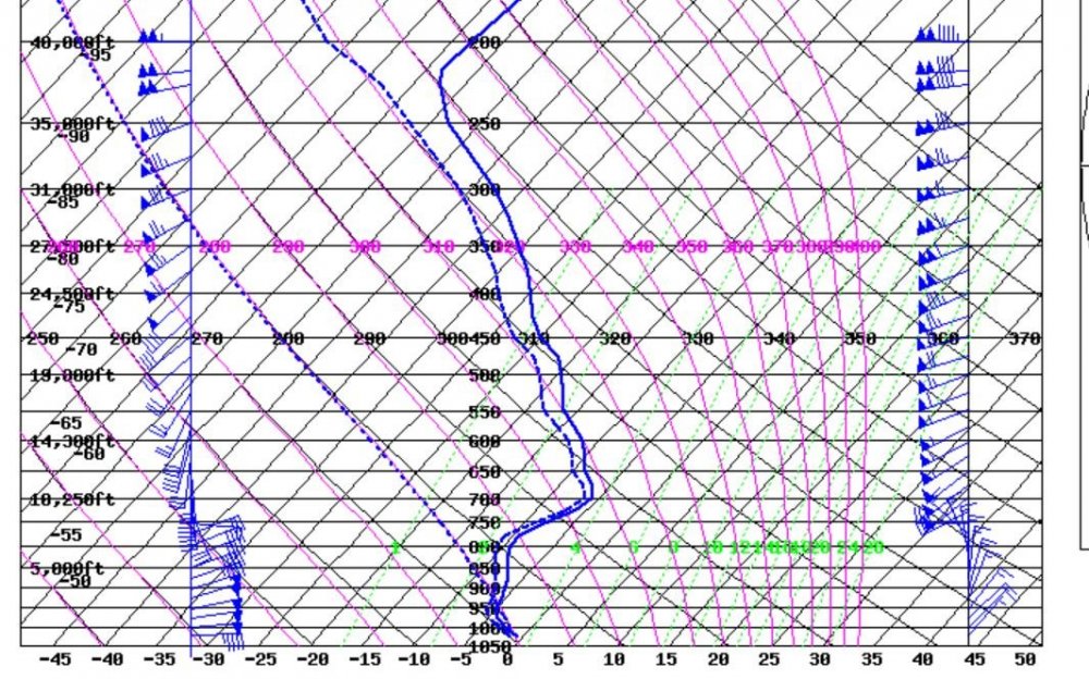
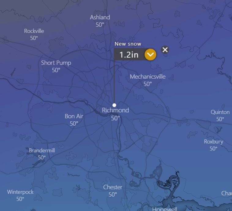
So, with continuing 6 hour & 12 hour updates, here's how the calculator works out again with the forecasting models for tomorrow on Thursday, Feb. 20. For Richmond, VA: 00Z, 12Z ECMWF -->> 0.3" & 1.2" for Richmond 12Z, 18Z CMC -->> 0.6" & 1.7" for Richmond 12Z, 18Z Gfs -->> 0.1" & 0.7" (ya, it rose to 0.7" on its 18Z output) 12Z Wrf -->> Trace 18Z HRRR -->> Trace Averaging these 8 totals yields -->> ~ 0.6" of snowfall for Richmond, bounded in that period between 2 PM and 10 PM, Thursday afternoon & night. In the past, the ??? marks typically hinge upon "will it be cold enough for snow?" That's not the question this time. It WILL be cold enough for snow in Richmond. The question is the EXTENT of the moisture & amount of dynamical forcing. The thermodynamic structure on forecast Skew-T soundings is GOOD enough for snow. The blue Skew-T is Nam's depiction at 4 PM on Thursday; entire sounding below 0°C. The pink Skew-T is Gfs' depiction at 4 PM on Thursday. entire sounding ABOVE 1000 mb is below 0°C The difference in thermal structure is that Gfs is ABOVE freezing, from ground level to 1000 mb, which is approximately 800 ft at 4PM. This is okay. The snow checklist says as long as the freezing level is LESS than 1,200 ft high, then it still has capability to fall as snow. The probability for snow tomorrow is HIGH in Richmond. Better than 50%. I'd place it at 70% chance, (AFTERNOON & NIGHT). Pending tonight's 00Z output, I'd say the overall AVERAGE snowfall totaling scheme for Richmond has RISEN to AROUND 1/2" TO 3/4". 1/2" to 3/4" of snowfall will cover all vehicles, and will also cover grassy areas, too. You'll still be able to see blades of taller, thicker grass, but it will be noticeably covered. ►► TRENDS, FOR RICHMOND, VIRGINIA ◄◄ The changes, since last night, for Richmond?? The snowfall amounts. Most notably, the ECMWF rising from 0 snowfall from 2 iterations ago, (yesterday morning), UP to: 0.3" from last night's iteration, UP to: 1.2" of snowfall on the current 12Z iteration, from this morning, (2/19), for Richmond. Gfs had previously shown consistency in 0.1" to 0.2" on its previous iterations, but NOW has surged up to 0.7" of snowfall. CMC's Gem has also risen from 0.6" to 1.7" between the 12Z & 18Z output. Nam continues between 4"-5" on its past 3 cycles. The new-age, HI resolution models are unchanged thus far showing only an unmeasurable, TRACE. While these new-age models of H-Rap & Wrf performed stellar in the predictions of the Dec. 2018 snowfall in Richmond, they did very poorly last November 2019, with the last memorable event, in that they again showed NO measureable snowfall. So pouring through the changes brings UP the snowfall for Richmond to between 1/2" to 1". This is plenty enough snow to see a wintery landscape. -- cyclogenesis
-
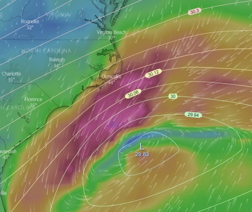
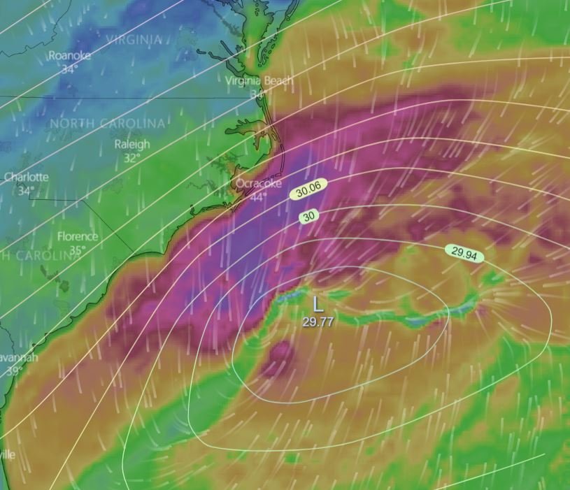
Forecast surface low positioning at 10 PM, Thursday night, 2/20/2020. These are the visuals on the comparative differences between the few models' depictions on the surface low's positioning at 10 PM on Thursday night. The Gfs & ECM are both identical in placement at 10 PM, but moisture is more generous on ECM's side. -- cyclogenesis.
-
It's ranging anywhere between 0.8" to 1.5" in the Greater Richmond, VA region.
-
February 19, 2020 ►► NEW Update! ◄◄ -- ECM has updated its snowfall for Richmond to now include 1" to 1 1/2" of snowfall. It now lies between the extremities of the 0.1" Gfs & the 4-5" Nam. -- cyclogenesis
-
February 19, 2020 --- This writing below ONLY APPLIES TO RICHMOND, VIRGINIA ---: For Thursday, February 20: On the snowfall forecast amounts for Richmond, Virginia: Here's what I've decided. 1/10" to 2/10" of snow seems realistic. How did I arrive at this projection?? I took 2 iterations of ECM, 2 iterations of Gfs, 1 iteration of CMC's Gem, 2 iterations of WRF. I disregarded the Nam forecast. (Disregarding reliable intelligence?) Because it stands way OUT, as an OUTLIER; that's why. What if I include Nam in the composite rendering of projections of snowfall amounts for Richmond? Then, I'll have to adjust the snowfall RANGE of variability between 1/10" to 1". Nam's last 2 iterations of output have been 4.2" and 4.4". Before that, from last night it was 6". (Why the stark contrasting differences?) The surface low position is FURTHER NORTH on Nam, than on Gfs & ECM. ECM was actually furthest South with its 00Z projection for 7 PM Thursday, showing it at a junction of Savannah's latitude & Cape Hatteras' longitude. Nam was at Myrtle Beach's latitude & Morehead City's longitude at the same time positioning on its 12Z morning projection for 7 PM Thursday. Also, too, the surface low is WEAK. Only 29.92" at its closest point at 7 PM by ECM, and 1010 mb by Nam at 7 PM at its closest point. The surface low only deepens once it begins moving AWAY from the U.S. East coast. The upper level pattern is equally as lame, with a zonal flow impairment. Here were the exact amounts that each model detailed: 6Z Gfs: 0.2" of snowfall for Richmond, VA 12Z Gfs: 0.1" of snowfall for Richmond. 12Z, Tues morn, ECM: 0 snowfall for Richmond 00Z, Tues eve, ECM: 0.3" of snowfall for Richmond 6Z Nam: 4.2" of snowfall for Richmond 12Z Nam: 4.4" of snowfall for Richmond 00Z & 12Z WRF: TRACE of snowfall for Richmond, LESS than 1/10" of snowfall. 12Z CMC's Gem: 0.6" of snowfall for Richmond. What's more disappointing to you snow lovers are the TRENDS on probabilities of precipitation are dwindling & coming down on the Gfs mos product: What was 66% from 18Z yesterday, fell to 49% at 00Z last night, fell to 43% at 6Z last night, fell farther to 37% from this morning's 12Z newest output from your Gfs. How about Nam? Nam has held solid at an 86% chance on this morning's forecast run. (So how do you account for these wide discrepancies in a forecast then?? Snow?? Or NO snow??) My interpretation on the subject is to CALL for snow to occur, but TRIM the amounts WAY DOWN. (What will 1/10" of snowfall look like?) 1/10" of snowfall will be enough to cover cars & trucks with a thin surface of snow. It won't completely cover your grass, though; although patchy areas will see some whitish hues. This will not create any traveling problems. EVEN in the REMOTE sense that I DO CHOOSE to BLEND IN the NAM forecast projection, bringing a possible highest TOTAL amount to 1 inch, with it averaged in to the other models' consensus, even 1 inch of snow still will not be enough to create travel problems. TIMING in RICHMOND: I think the timing of said projected snow will occur between 2 PM and 10 PM on Thursday. I also think you'll find on radar some finger sleeves of radar return echoes starting up as soon as late Thursday morning AIMING from Southwest to Northeast in our direction, but I expect this late morning echo returns to be VIRGA to start, with the lower levels too dry just yet. I believe the more notable snowflakes that will become more visible will come in the LATE afternoon hours between 3 PM - 8 PM, for Richmond, VA, although I do expect you'll see snow flurries flying in the air as soon as EARLY tomorrow afternoon, on Thursday, Feb. 20. Besides, it has to snow! It's the 20th on 2020, and on the 02nd month! Last thing to close with is this: While there still remains a notable chance that no snow will accumulate, (not enough of it), I do still think you should get to see snow flurries falling lazily in the air on Thursday afternoon. -- cyclogenesis
-
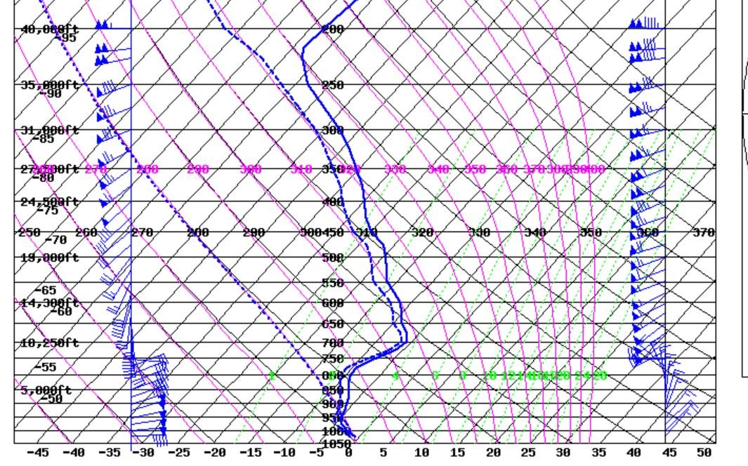
When it precipitates tomorrow, in Richmond, Virginia on Thursday, February 20, 2020, it WILL be ALL SNOW! Here's why: In Richmond, Virginia: 12Z forecast Skew-T soundings for tomorrow show that -- The freezing level height begins around 814 ft, AGL, tomorrow, (~1000 mb), and for ALL LAYERS ABOVE 814 ft, at 1 PM on Thursday, Feb. 20, temperatures above that height of 814 ft will be BELOW FREEZING. -- While temperatures from GROUND LEVEL up to 814 ft. are forecast ABOVE freezing, this is still permissible to have snow, as the snow forecasting guidelines provide that as long as the freezing level is BELOW 1,200 ft, then snow can still occur. ( Reference Table IV, Forecasting Snow, cited at: https://www.weather.gov/sgf/winter_checklist_paper) Okay, so there's that. -- The 1000-850 mb thicknesses are below 1,300 meters during the entire duration of this snow event for Richmond, VA, (1,284 - 1,267 m). -- The 1000-500 mb thicknesses are below 5,400 meters during the entire duration of this snow event for Richmond, VA, (5,356-5,292 m). -- 850 mb temperature will be from -8 to -11°C. -- Your 700 mb T is running at -7 to -10°C during the event tomorrow. (Are there any NEGATIVES and PITFALLS to thwart the snow, at all?) A couple negatives to start with. #1.) Your starting surface temperatures at 1 PM on Thursday are forecast to run at 34° by your Nam and 42° by your Gfs. Rest easy, though, as SNOW can still occur with the SURFACE temperature ABOVE freezing. #2.) I do see an intervening DRY LAYER on Skew-T forecast soundings tomorrow on your Nam projections, from ground level up to 5,000 ft, ~ 850 mb at 1 PM on Thursday, Feb. 20. The DRY LAYER depth is even greater at 10 AM, up past the 10,000 ft mark. (What does this mean, effectively?) It means it starts off as virga, until the lower-layers saturate from the top - down. This is forecast to happen by 4 PM on Thursday, Feb 20, in Richmond, VA. A saturated column profile is forecast by that time, and all layers are forecast to be at freezing. (Nuh-uh! Not the surface layers from Mos!) Okay, at the surface Nam shows 33° at 4 PM and Gfs, at 40° at 4 PM. Look for that 40° to be a bust at 4 PM. Once it starts precipitation, ambient air temperatures start dropping quickly as it'll wet-bulb about 1/3 of the way down towards the dewpoint T. And again, gang, don't be getting hung-up on the surface temperature, because it will STILL SNOW with SURFACE temperatures ABOVE 32°. Wet bulb zeros are forecast so low, and dewpoint temperatures are forecast so low, in the 20 to 23° range. What this may effectively do is tear in to your snowfall amounts, too, at the START of the event in the EARLY afternoon. By evening, though, saturation of the vertical depth of the troposphere will become MORE COMPLETE and WHOLE to produce better snowflakes, although Richmond is quite a far ways removed from the positioning of the surface low transpositioning, so don't be getting too overly excited about the amounts. I'll produce another writing for Richmond, VA detailing snowfall amounts in a subsequent writing later on. -- cyclogenesis.
-
Hello, RIC Airport ~ I was a bit unsure of what would transpire myself, in terms of accumulation, on the Tues. Nov. 12 event. I felt pretty good about there being snow; but the question of accumulation on the ground had me wondering, on account of the warm ground temperatures, and the Mos output projections of surface air temps in the mid 40's at the time of the event, which proved otherwise, instead to be 33°. I've been a long time resident of South Louisiana, before moving up here to Richmond, VA recently just 1 year ago. As such, being in South Louisiana for 1/2 my life and the other half my life residing in South Florida prior to that hasn't given me sufficient exposure to hardly any wintery precipitation events. I've had plenty a work out with severe weather events in New Orleans, as well as hurricane & tropical storm events, but only a rare, small handful of wintery precipitation events. They are the most time-consuming when analyzing the start time & end time, & proportionate amounts in how much is rain; how much is snow, also the wintery type of precipitation, (sleet, freezing rain, vs. snow), and the QPF associated with it, and when & where the cut-off line will be with precip. vs. no chance at all. What I discovered with this particular event, was that using the Skew-T sounding forecasts & the raw model data from it, was far more impressive in deciding the snow determination, and for this one particular case the 540 Dm thickness line determinant really was quite amiss and had no relevant impact bearing on deciding snow for this event. -- cyclogenesis
-
November 14, 2019 I've been wanting to write a HIND-CAST summary on this Tuesday, November 12, 2019, snow event in Richmond, VA, but just now getting around to it. I took note & wrote down on paper, a 42-48-hour forecast from the 7 PM, Sunday evening, (00Z Mon), suite of forecast products on the projections of the snowfall for Richmond, for that Tuesday, Nov. 12 snowfall event. LOOKING BACK AT WHAT FORECASTS SAID FROM SUNDAY EVENING..... A POST-MORTEM ANALYSIS. In a 42-48 hr. forecast -- from back then -- here's how 4 forecast models were projecting it: 00Z Wrf 1/10" to 1/2" between 11 AM to 2 PM. 12Z Wrf Trace. 00Z Nam 1.6" of snowfall 10 AM to 1 PM Tuesday 06Z Nam 2.6" of snowfall 10 AM to 4 PM Tuesday 00Z ECMWF -- 1" of snowfall -consistent later with its 12Z iteration. 00Z Gfs 3.6" of snowfall 10 AM to 4 PM Tuesday. 06Z Gfs 0.1" to 1" snow 10 AM to 1 PM Tuesday. So, let's look at timing. Those which indicated a TIMING, were all about 2 hours too soon with the snowfall starting, as it started closer to 12 Noon -- but NOT bad, by only being off by 2 hours. And TIMING for shut-off of snow, also not bad being anywhere between +/- 1 to 2 hours. Nam averaged out to be 2.1" blending its 00Z and 6Z iterations together. Gfs averaged out to also be 2.1" blending its 00z & 6Z iterations together. ECMWF was showing a consistent nearly 1" snowfall projection in its 00Z, and later 12Z projection. Wrf averaged out to be 0.15" with its 00Z and 12Z iterations. So the most disappointing models that I saw performing the worst, was the new-age higher resolution models of WRF and HRRR. The last 2 iterations of the WRF showed ONLY a TRACE at best. The HRRR 00Z and 12Z iterations showed NO snow, but its intervening hourly updates were FLIPPING back and forth with YES, SNOW; NO, SNOW; YES, SNOW; NO SNOW. So this is really disappointing to see that these newer-age higher resolution models suffer in performance. Now I also performed a check inspection of a 7-point checklist determination for / against snow. 3 indicators answered NO to snow, which included: #1.) the 1000-500 mb thickness being forecasted around 545 Dm at 1 PM on Tuesday, Nov. 14th; #2, the forecasted surface temperature to be above 35°; #3.) The 700 mb temp. to be greater than -4°C. I don't care about that 3rd determinant of 700 mb temp being warmer than -4° C, but I do focus on the 1st 2 factors. Probably the GREATEST SHOCK in this forecast was the MOS SURFACE temperature forecast guidance -- the last iterations of the 6Z GFS Mos and the 00Z Nam MOS, on THEIR SURFACE TEMPERATURE forecasts, for Richmond. What did they INDICATE??? The GFS Mos projected a surface temperature of 44° at 1 PM Tuesday. The NAM Mos projected a surface temperature of 47° F What was the ACTUAL, VERIFIED surface temperature at 1 PM Tuesday?? 33° WOWSIE!!! This is a HUGE, HUGE BUST!!! This is OFF by 11° to 14° TOO WARM.... The raw model guidance I reviewed from Nam alpha-numeric text, and its Skew-T sounding, though, in its 18 hour forecast from 00Z the evening before WAS SPOT-ON, in its surface projection of 33°. In fact, the inspection of its Skew-T sounding fully supported a SNOW sounding with all temperatures BELOW freezing from 400 ft on UPWARD. My snow notes I recorded years ago read: Wet snow CAN occur with temperatures well above freezing, for instance 38° to 42° as long as the above-freezing temperatures are confined to the LOWEST 500 ft from ground level. This was the case by 1 PM Tuesday afternoon. The snow occurred over an approximately 3 hour period roughly from 1150 AM to 244 PM on Tuesday. In the 1st snowing hour, the snowfall RATE was coming at 1/2" per hour. I had a lot of initial skepticism, if the snow would accumulate, given the relatively WARM ground temperatures this autumn season, and the fact there was plenty of sunshine the day before with a high temperature of 70°. This, on top of the expectation that the surface temperatures would be well-above freezing -- probably in the low 40's AT BEST; perhaps as high as both MOS projections of 44-47. So both these assertions I figured to argue against accumulation with warm ground temperatures **AND** surface temperatures in the 40's. Well, the warm GROUND temperatures was sure enough fitting, but the AIR TEMPERATURES came in at 33° by 1 PM. In fact, here's a little tidbit to take note of. The AIR temperature was 51° at 945 AM on Tuesday morning. Now...at SNOW START TIME, the temperature had PLUMMETED down to 35°, by SNOW START TIME, about 1150 AM. So that's a WHOPPING 16° temperature DROP in just 2 hours' time!! In fact, there was a 4° DROP in temperature in just a short 26 minutes from 38° at 1130 AM DOWN TO 34° by 1156 AM. Why so quick? Latent heat exchange, going from snowflakes and hitting the rainy surface from earlier morning rain, taking heat from the ambient air temperature to go from a solid to a liquid. That's my explanation. The end result out of all this was 9/10" (0.9") of snowfall that fell in Richmond. It looks BEST when trying to figure out snowfall projections to take several iterations of several different models and blend them together to average out the amounts over at least 2 to 3 cycle periods, for instance 00Z, 06Z, and 12Z. The erroneous displays from WRF and HRRR cannot be ignored, and I'll be watching in future snow events to see if this was a one-time event hiccup. One last tidbit I wanted to memorialize about this event, was even IN SPITE of all the rain covered grass, the warm ground temperatures, and the fact the air temperature was as warm as 51° just 2 hours' prior to the onset of the snow falling in Richmond, I started to SEE & note accumulation on the GRASSY surfaces and on vehicles in as little as 30-40 minutes time, and at a time when visibilities were reducing to 1/4 mile in heavy snow rates. -- cyclogenesis
-
October 31, 2019 this pre-dawn Thursday morning 340 AM EDT * * * Western Richmond to get its clocks cleaned good with a rough squall line coming tonight, on Halloween night, Thurs., Oct. 31 * * * * * * Expect a Tornado Watch & Severe Thunderstorm Warnings to get hoisted starting 8 PM to 11 PM starting for Richmond West first, then to East. A Watch will precede these warnings by some 2 - 3 hours earlier in the early evening hours of Thursday, 10/31. * * * * * * High GUSTY winds and occasional damaging wind gusts will be your greatest fear factor * * * I. Introduction. An Upper level low centered at the Iowa-Missouri border at 8 AM Thursday morning, 10/31. A strong trough of low pressure at the mid levels will extend Southwest of this low in to Oklahoma at that time. 12 hours later, at 8 PM, Thursday night, 10/31, the upper trough tightens & becomes slightly negatively-tilted (strengthening), and extends from Southern Great Lakes region Southward to Northeast Tennessee. A swath of strong cyclonic vorticity advection, previously known as PVA, will be in position and a player in to strong dynamic forcing that will ignite & strengthen a band of forced showers in broken squall lines sweeping from Central Virginia through Eastern Virginia. Upper divergence values looks strongest NORTH of Richmond across Northern Virginia, by GFS; whereas NAM reserves a pocket of strong UVV from upper divergence down SOUTH of Richmond around 10-11 PM. There's enough belief from simulated predictive radar sequences that lead to the promotion of severe weather occurrences, in spite of a rapidly decreasing amount of Surface CAPE, as the night grows from 8 PM to 11 PM, the timing of receiving some stout, intense squall lines of showers in the Greater Richmond & surrounding outlying suburb areas on Halloween night. By 11 PM, the upper low and associated trough lift Northeastward in to the Southeast Great Lakes to the West Virginia region, with the convective forcing for heavy squall lines of showers already having passed through Richmond by 11 PM Thursday night, 10/31. At the surface the strong cold front reaches Richmond between 12 AM Midnight to 1 AM on Friday morning, 11/1. Low temperatures for Friday morning, in Richmond get knocked back to the upper 40s. II Severe Weather Indicators. While I'm seeing only a scant supply of SB Cape, to run a forecast of about 500 J/kg, the dynamics from the upper trough positioning, height falls, and pressure falls, together with the very beefy kinematics should compensate to turn over a few instances of severe weather, particularly damaging HIGH WIND GUSTS on Halloween NIGHT, accompanying squall line bands of heavy showers. The way I see it, 300 - 500 m2/s2 of helicity is forecast over a wide area of Eastern Virginia at the onset time of 8 PM Thursday night, 10/31, so I believe this necessitates a Tornado Watch area. A look at projected forecast wind gusts, the WRF indicates areas of PEAK WIND GUSTS of 40 to 50 kts eligible to occur between 8 PM and 12 AM Midnight over Eastern Virginia, with 9 PM the peak time, as that's the closest timing of severe squall line winds around that time in the Richmond area. In another rendition a 2nd model forecasts a 45 mph peak wind gust, (52 mph), in Richmond at 10 PM, with the squall line of showers. GFS calculates a possible peak wind gust up to 59 mph Nam calculates a possible peak wind gust up to 60-67 mph, Thursday night, 10/31, around 8 PM to 9 PM at night. III. The Wind Shift. The wind shift for Richmond looks to come between 12 AM Midnight and 1 AM, Friday morning, 11/1. This will markedly drop temperatures to the upper 40s on Friday morning. It'll become Strong South winds of 15-25 mph & gusty will be prevalent during Halloween afternoon. By early Halloween night, Thursday night, 10/31 from 8 PM to 12 AM, winds get strongest, and will run at speeds of 20 to 30 mph, with gusts to 40-45 mph in heavy rain squalls Thursday night. Surface low pressure over Central Ohio at 8 AM Thursday morning will glide Northeastward in to Upstate New York by 11 PM Thursday night, 10/31, with the trailing cold front slicing through Eastern Virginia at that time, 11 PM Thursday night, Halloween night, 10/31. IV. Rain Amounts, centered on Richmond, VA Because I expect this squall line to be a fast-racer, and not puttering around nor stalling either, I suspect rain should occur in a relatively short time span of about 1 hour to 2 hours. Selected forecast models indicate between 1/2" to 1" of rainfall for the Richmond area as follows: Nam -->> 0.58" Gfs -->> 0.62" Wrf -->> 0.15" to 1.15", (lowest EASTERN counties; highest WESTERN counties) 6Z iteration of HR-Rap -->> 0.46" at RIC. 00Z iteration of HR-Rap -->> 0.97" It'll be a goodly amount of rain, but it'll come in a shortly amount of time, roughly a 2 hour period, and not one of these extended range events. V. Call to Action Statement. Impacts on the Halloween outdoor activities need to be readied and prepared for a period of HEAVY, DOUSING rain, especially between the HOURS of 8 PM to 12 Midnight for the greater surrounding metro area of Richmond. 8 PM for WESTERN counties, as Powhatan/ Goochland and up to 12 AM Midnight for EASTERN counties such as New Khent. The central CORE of the Richmond area should be affected by heavy squall line showers between 9 PM to 11 PM. IN ADDITION to heavy dousing of rainfall, during outside Halloween activities, the outside revelers must also prepare their costuming for STRONG WINDS that can take speeds of 20 to 30 mph, with gusts upwards to 40-45 mph, especially between the hours of 8 PM and 12 Midnight. If trick or treating can be arranged EARLIER in the evening, closer to supper time hours of between 4 PM to 7 PM, then this will be a more optimum timing to avoid the squall lines of heavy showers and higher gusty winds which I expect to occur during the hours of 8 PM to 12 AM Midnight, later Thursday night, 10/31. Temperatures start around 77° at 5 PM, Thurs aftn., 10/31, and tank down to 68°, by 11 PM Halloween night; but the strong winds will create a "chilling" effect in the air so warmer clothes will be needed later at night. -- cyclogenesis
-
October 19, 2019 this Saturday afternoon * * * Extra-Tropical Storm "Nestor" will carry its effects in to Eastern Virginia starting LATE tonight, Saturday night/Pre-Dawn Sunday morning, 10/20, and last throughout much of the day Sunday * * * * * * A goodly amount of rainfall over a 15-hour period, and strong winds will both be present in Eastern VA * * * The way I see this playing out for Richmond, VA is: I see the rain starting up first, a short distance after Midnight tonight, going on during all the pre-dawn hours Sunday morning, 10/20, and continuing well in to Sunday morning, past sunrise. It will rain all of Sunday morning in Richmond, and carry in to the late Sunday afternoon hours before ending around 4 PM to 5 PM. This should be a continuous moderate rain, to occasionally heavy, for a few hours. Then, a good 12 hours after the rain starts, THEN, secondly the WIND should amp-up during Sunday afternoon hours. -- Timing of Rain, in Richmond -- Here's how I think the rain timing will go for Richmond, VA: Rain Start time: 1 AM to 2 AM, for Richmond Rain Ending time: 3 PM to 5 PM, for Richmond -- Rainfall Amounts, in Richmond -- I believe we'll see between 1" to 3" of rainfall, storm total from the remains of "Nestor" in the Richmond area. A few of the model projections are: 00Z WRF: 0.95" 12Z WRF: 2.00" 12Z HR-Rap: 2.64" 12Z NAM: 2.29" 12Z GFS: 0.98" -- Timing of HEAVIEST RAINFALL -- It's looking to me the HEAVIEST, GREATEST rainfall in Richmond will occur, predominantly in the SUNDAY MORNING hours, with some carry-over in to the early afternoon, between 5 AM to 2 PM for Richmond, with greatest starting out West soonest (around 5 AM), and greatest out East, starting 1-2 hours thereafter and ending 1-2 hours later out East, around 3 PM, East. -- Highest WINDS -- For this, I've examined 2 iterations of 1 model and 1 iteration of another model. The consensus between the 3 models indicates that the PEAK WIND GUSTS in the Richmond area should reach in the bracket of 35 mph to 45 mph. This HIGH wind will be NOTICEABLE, and walking in to the wind will be difficult. Some small twigs may be blown in to roads from these winds, and high profile vehicles, as in tractor-trailers and RV's will have especially noticeable difficulty driving on East to West / West to East oriented roads & highways, particularly starting from mid-morning and carrying ESPECIALLY in to Sunday afternoon hours between 1 PM and 8 PM, where I think WINDS will be their greatest, with gusts of 35 mph to 45 mph. -- Timing of PEAK WIND GUSTS -- I think the peak wind gusts from "Nestor" will come as the heaviest rain is pushing out. So, the timing on greatest peak wind gusts, I think will come bounded between 1 PM and 8 PM Sunday afternoon, where peak wind gusts should climb up to 35 to 45 mph, from the NORTH. Earlier in the mid-to-late morning where winds may peak between 30-40 mph, winds will be Northeast to North. Then, by afternoon, winds should back to a North-Northwest direction and accelerate upwards to 35 to 45 mph in gusts. I don't anticipate flooding problems, as this rain will be fanned out over a 15-hour period, at a steady moderate rate. I also don't anticipate winds causing any significant damage either. Just many leaves and some small twigs broken off from tree branches, with difficulty walking in the wind and driving in the wind with high-profile, (tall), vehicles, from late Sunday morning through Sunday afternoon & evening. -- cyclogenesis
-
August 13, 2019 this Tuesday morning 705 AM EDT *** Severe storms a good chance over Eastern Virginia this afternoon & evening, Tues., 8/13 *** *** Most likely form of severe is high wind gusts *** *** Multi-cellular & line segment storms are indicated, in Eastern Virginia *** *** A Tornado or Severe Storm Watch will be needed from early afternoon in to early nighttime, to include the Richmond, VA and Eastern VA region *** This writing applies to Richmond, VA & surrounding counties. I. Overview. A wildly active day & night containing multiple rounds of showers & thunderstorms appear imminent starting this afternoon and carrying through the late evening hours, this Tuesday, August 13. There are indications from a couple of the forecast models that winds aloft will increase by late afternoon around 4 PM to 6 PM, to accentuate a chance for severe storms containing high winds, from mid-afternoon onward to evening. Additionally, helicity forecasts, late in the day, finally rise to a level to which an isolated tornado is eligible to occur; although newest forecasts have toned down helicity from a couple days back, and thereby the attendant tornado threat. II. Timing of storms for Richmond, VA on Tues, Aug. 13 A.) Richmond Timing for all showers & storms. I believe the best timing for a scattering of showers & storms for Richmond to span between 1 PM to 11 PM this afternoon & early tonight. Repeated periods of showers & thunderstorms should occur this afternoon & tonight. I do expect a severe weather watch to be issued during this time frame to cover Eastern Virginia. B.) Richmond Timing for *SEVERE* storms. The severe weather, for the Richmond metro, I think will be timed between 2 PM and 8 PM. There is indication from several of the forecast models that a nighttime MCS, (large cluster of showers & storms), will re-develop 100-200 miles West-Southwest of Richmond over either Central or South-Central Virginia beyond 8 PM tonight, and propagate towards the East-Southeast. There are divided differences in PLACEMENT of this nighttime MCS, with Nam and Wrf both showing Richmond to either be dry or miss it, after 8 PM tonight. The other camp, from Gfs & UKMET, show a large area of showers & storms developing over Central VA and spreading Eastward between 8 PM and 2 AM tonight. Storm motions this afternoon will be a brisk pace, moving East-bound at 30-40 mph, and I do expect warned T-storm cells this afternoon & evening both North of Richmond and South of Richmond spreading Eastward in the evening hours. III. Tornado Target. The surface low is mirky to make out with no model exactly agreeing in placement, timing, or even definition. It's appearing a surface low will exist, transiently, for a brief period in the late afternoon, early evening hours over Northwest Virginia, and slowly pace Eastward during the early nighttime. I'm thinking the best helicity for a tornado will be lagging 2-3 hours behind the most robust cellular storms placement, occurring mostly to the West of storms today, and for this reason, I believe the highest severe threat is from high winds. My best preference for an identifiable tornado location is bounded between Fredericksburg, VA to Louisa, VA to Ashland, VA between 3 PM to 7 PM this afternoon. Here, in this vicinity, it looks to have about 200 - 300 m2/s2 of 0-3 KM helicity. Because the 850 mb forecast wind profiles are West-Southwesterly throughout the afternoon & evening, though, this will favor a more bonafide threat for high wind gusts, over the tornado. The tornado threat can't be excluded because there is some arcing in the hodographs between 2 PM and 8 PM, between 0 to 1 KM above; but after 1 KM, it's straight-lined. So there may be just enough 0-1 KM helicity present to produce a few tornadoes. IV. Rest of Severe Weather Details. In other areas, the CAPE from a couple of forecasting models does point to between 1800 to 2200 J/kg, and an important key I look in to is the 850 mb wind strength, which is down from 2 days ago. It's now appearing winds at this 850 mb level will be running West-Southwest about 20 kts. This is borderline in what I seek for the MINIMUM threshold for summer-time severe given this Cape forecast. A look at 6Z Nam, shows 20-25 kts for a good part of the day, so getting above that 20 kt threshold is GOOD for the production of severe storm wind gusts. I'll note that the WRF is pointing towards an acceleration of winds at this 850 mb level to 25-30 kts between 4PM to 5 PM. Should this materialize, then I do expect a more widespread threat for damaging wind gusts by late afternoon. Further to this, the 00Z Nam had indicated a 50kt 500 mb wind max spreading atop Richmond at 5 PM today. To me, for this time of year, in summer though, the 850 mb winds are more important to me in the severe weather bracket of for surface high wind gusts than at 500 mb. But those higher speeds at 500 mb, with that wind max, can help promote better updraft speeds, and resultingly higher dbZ turnouts on radar reflectivity. And I do believe we'll see just that, too! When inspecting the upper divergence at 250 Mb, the 00Z & 6Z Nam are suggestive at forcing for ascent to be prime between 11 AM and 5 PM, a bit sooner than other model timing for storms on this event. Both the French & German models suggest showers & storms will be finished with Richmond by 8 PM. Storm integrity looks most solid West of I-95, wherein both lightning density & VILS look their best, and then when storms pass East of I-95, the integrity looks softer, although I still believe capable of producing high wind gusts. Both Gfs & Nam forecast soundings suggest a peak wind gust to 53 kts in afternoon soundings based near Richmond, VA, along with lifted indices to -5 to -6 C. It's interesting, though, that WRF-ARW does not indicate any surface wind speed gusts over 40 kts in its hourly grid domain from 00Z. That's disappointing, considering the fiery convective portrayal this afternoon. V. Rainfall Amounts, Richmond. While PW, precipitable water, is forecast to run between 2.10" to 2.40" from 8 AM this morning to 11 PM tonight, the rainfall projected totals aren't that much. The reason is because of the anticipated fast forward progression from West to East of shower & T-storm movement, racing between 30 to 40 mph. Rainfall projected for Richmond, VA for this afternoon through early tonight: 00Z UKMET: 0.36" 00Z Gfs: 0.89" 00Z Nam: 0.24" 00Z C-Gem: 0.54" 00Z WRF: 0.05" 00Z HR-Rap: 0.88" 06Z HR-Rap: 0.98" 00Z ECMWF: 0.20" 00z Arpege: 0.20", before 8 PM 00Z Icon: 0.50", before 8 PM This yields a 10-model average of 0.48" for the Richmond, VA metro area bounded between this afternoon & tonight, 8/13. -- cyclogenesis
-
June 17, 2019 this Monday night 1115 PM EDT Hey Gang, Those of yous guys in the Eastern Virginia region, I think it continues to look interesting for severe storms coming up...especially on Thursday evening, June 20. Also, I'm getting some subtle clues that tomorrow evening on Tuesday evening & Tuesday night, this may be a more widespread & lingering heavy thunderstorm event that unfolds across Southeast - Eastern Virginia, the way the Precip. Water mappings show a persistent plume of higher moisture feed that hangs in the same area during the evening & overnight hours. Simulated rainfall also suggests it on a couple of the forecast models. As for Thursday evening, LOTS of high wind momentum gathers quickly with a great amount of instability & moisture all pooling together for this event. Lifted indices quite low at -7°C. SI at -6°C & K-index in upper 30's all highly supportive of T-storms. SW fcst to be 409-487 & TT's at 53. This all spells a good likelihood for SEVERE STORMS in this area come Thursday evening. -- cyclogenesis
-
April 26, 2019 this early Pre-Dawn Friday morning 149 AM EDT * * * Risk of Severe Storms across Eastern Virginia today on Friday, April 26, 2019 * * * * * * Few severe T-storm warnings, with a watch box quite possible around late morning through the late afternoon * * * * * * High wind gusts & hail to be the main perils starting late morning through late afternoon * * * I. Introduction. It's appearing that the best timing, in Richmond, VA, for a few severe storms will run between 10 AM and 6 PM, with the peak in the early afternoon to mid-afternoon. The appearance on radar should be multiple clusters of cellular activing both before a thin-banded squall line and shortly afterwards. A pre-frontal trough is scheduled to sweep through the Richmond, VA area by late Friday afternoon about 5 PM, with wind shift to the West. Then the cold front should pour in colder air to Richmond, later Friday night starting 10 PM to 11 PM. II. Upper levels. An upper level trough extending from Eastern Michigan South through Central Kentucky & Tennessee at 11 AM on Friday morning will dig Southeastward to a position extending from Western Pennsylvania to Western Virginia & Central North Carolina / South Carolina by 5 PM Friday. During this time of late morning through afternoon, a SW 850 mb ~5K ft low-level jet will be in place across Virginia, at speeds of 35-45 kts. This, atop, a mid-level jet at 500 mb, ~19K ft, 45kts - 55 kts will work together to create 0-6 km shear between 40-50 kts, with a surface wind from the South-Southwest at 15-20 kts, just prior to the pre-frontal surface trough passage in the late afternoon. Surface dewpoints will rise to the upper 50's during the early afternoon, with a high temp. in Richmond reaching 77°. Precipitable water, PW, amounts increase upwards to 1.4" by early afternoon, with the best pooling of moisture at that time, before falling backward by later afternoon, with the pre-frontal trough wind shift to the West. III. Severe Indices. Most of these indices do not look that impressive on areal forecast Skew-T soundings. Helicity looks low & flat, generally 200 - 250 m2/s2 on account of the straight-lined hodographs overhead Richmond at peak timing of severe. With uni-directional wind profiles from late morning to mid-afternoon, coming from the Southwest, this suggests a better threat for a few damaging straight-line thunderstorm wind gusts, vice a smaller tornado threat. Conventional forecast soundings from both models show a peak wind gust from Gfs to be 48 kts and from Nam to be 51 kts with storms between late morning through late afternoon. Amidst other models, WRF higher resolution model doesn't indicate any peak wind gusts even to 40 kts during its one-hour peak wind gusts through the convective period. One area that did catch my eye was the forecast temperatures at 700 mb & 500 mb running between 1°C at 700 mb at 2 PM and about -14 to -15°C at 500 mb at 2 PM. These 500 mb temps cool further to -20 to -21C by 8 PM. With this cold-air advection spreading in ALOFT in the upper levels during the afternoon, this could help promote a HAIL threat with SB-Cape running between 750 J/kg to about 1,200 J/kg at the height of the event. Wet-bulb zero heights by both forecasting models reach the favorable 8000-9000 ft level for hail production. The trickiest part about forecasting hail is that the thermal profile aloft comes typically most favorable *after* the best upper level ascent, (upward dynamic forcing), has already passed. While CVA / PVA is evident at 500 mb, this supports the lightning-thunder threat as cyclonic vorticity advection promotes this aspect, the trouble I'm seeing is that H-Rap doesn't show much lightning density strikes showing up, even though spotty convective cellular activity reaches 50 dbz in spots across Eastern Virginia. Watch to see if later hourly updates includes some increase. Hail storms are typically associated with plenty of lightning occuring within the cumulonimbus cloud. I reviewed 250 mb upper divergence dynamics, and don't see anything heralding; Gfs 700 mb strongest UVV's, (Upward Vertical Velocities), come in to the RVA area around 2 PM, and it appears most models are anticipating a broken line of storms that comes together as it advances in through Eastern Virginia, perhaps firming-up the strongest once passing EAST of Richmond. IV. Rainfall Amounts. -- Centered on Richmond, VA -- A.) Gfs -->> 0.49" between 8 AM and 8 PM Friday B.) Nam -->> 0.35" between 8 AM and 8 PM Friday C.) ECMWF -->> 0.81 , 8 AM - 8 PM Friday D.) UKM -->> 0.32" , 8 AM - 8 PM Friday E.) WRF -->> ~~ 0.50", approx. 8 AM - 8 PM Friday Other non-decorated, non-celebrated showers will occur prior to 8 AM Friday morning, and this is already light rain showers appearing on radar at 145 AM as I write this. V.) Conclusion While I don't see this shower & thunderstorm event being as grand as the previous 2 events, in the preceding 1-2 weeks prior, there is enough instability & speed shear present on Friday which should sustain several waves / clusters of showers and a few thunderstorms, throughout the day, with a few storms having the eligbility to reach severe levels, (high winds/hail), as the approaching upper short-wave trough sharpens & approaches the Mid-Atlantic states by early this evening. -- cyclogenesis
-
April 19, 2019 this Pre-Dawn Friday morning 115 AM EDT * * * Still a good chance for severe storms & HEAVY RAINFALL for the Richmond, VA area, Friday afternoon & Friday night, 4/19 * * * * * * Tornado watches likely to be issued by early Friday afternoon, for Richmond & Eastern Virginia * * * * * * Predominant threat still looks to be spots of wind damage & heavy rainfall, ponding of water * * * * * * 3 distinct rounds of storms coming * * * I. Timing for Richmond, VA. I'm seeing 3 distinct time periods for showers & storms for Richmond, VA on Friday. The first wave comes betweeen 3 PM and 4 PM. The 2nd more serious severe round of weather comes in the evening hours between 5 PM and 7 PM, and then after 8 PM, comes the 3rd round which I think will be the heavy rain period spanning from 7 PM onward to 11 PM. Viewing late this Thursday night, at timing progressions, appears this weather event will present itself starting as soon as early Friday afternoon, in the form of detached showers randomly racing Northward through the area. Shower activity will first start out WEST of us and SOUTHWEST of us in the late morning hours. Then, about the timing in the early afternoon, between 12 PM and 2 PM, I think the 1st tornado watch will be issued close for Richmond. Storm warnings for detached multi-cellular activity should come between 1 PM and 5 PM. Interestingly enough, WRF's animation shows NO pockets or LINES of 40+ or 50+ 10 meter surface wind gusts in its 1-hour grids, as I step through its 00Z, 4/19 output. Non-important, low-ranking moisture advection showers will begin racing Northbound late Friday morning in our area, with SB-Cape increasing during the 11 AM to 2 PM time frame. II. More details. Discrete & unattached multi-cellular showers & a few storms should develop across the area between 11 AM and 2 PM, well ahead of the parent line, since a strong morning capping inversion at 8 AM, shown at 12Z/8AM on Nam's 12 hr depiction btwn 800 mb - 750 mb withers away completely by 2 PM, with 0 CINH, (convective inhibition) remaining by 2 PM. It's appearing there'll be a revised 750 J/kg, to at most 1,000 J/kg of SB-Cape available for Friday afternoon's storms in the Richmond area. While severe weather parameters such as SWEAT, Cape, helicity, Total-totals have all de-escalated since I last wrote you, and numbers have come down a bit, it cannot be ignored that a stout 45kt-55 kt low-level 850 mb jet and 55-60 kt 500 mb jet will be overhead during peak afternoon hours, concurrent with rising Cape levels, although still a bit on the low side of 750 - 1000 J/kg. While neither speed shear nor directional shear for long-lived supercellular storms are present, the overall wind momentum throughout the depth from boundary layer to mid-levels is impressive enough to be able to transport some of this high wind momentum downward in the heaviest rain shafts produced of the multi-cellular & linear squall line modes. You generally see a greater occurrence of wind damage with a veered WESTERLY component, but in this case we're dealing with a SOUTHERLY direction, and a fetch of deeper moisture, which is why I believe the heavy rain & flooding threat is kept alive for Friday night across Virginia. So, not the most idyllic directional consideration for production of severe winds, the speeds are still great enough to produce instances of wind damage. Also, on account of the TIMING of day, during the afternoon hours, helicity is shown to run upwards to 300 m2/s2 by WRF's modeling scenario, while NAM shows a spiked pocket of 350 to 500 m2/s2 helicity at 5 PM very near the Richmond area. WRF's maximized CAPE timing is shown to come about 6 PM to the RVA area, right along the SAME TIMING of an approaching squall line to Richmond in the LATE afternoon hours between 5 PM and 7 PM. This timing of late afternoon & early evening 5 PM to 7 PM looks to correlate to the highest amount of Cape nearest to Richmond, at a timing when a squall line should be traversing the scene, along with the helicity, so tornado threat & SEVERE WIND THREAT look to be MAXIMIZED, I believe, at this timing of late afternoon & early evening for Richmond. Beyond 7 PM, it's a matter of how much RAIN & STORMS LINGER stagnate behind the parent line, as this is where I see the heavy rainfall event unfolding from Friday evening in to Friday night, from 7 PM to 11 PM. This is the timing for a few flood warnings to be issued. A higher BAND of PW's, precipitable waters, (1.6" to 1.85"), arrives our area between 11 AM to 2 PM, and REMAINS this HIGH, onward to 11 PM, Friday night. Virginia Beach & the Hamptons looks to get their heaviest rain threat later in the night, 11 PM to 2 AM. All of this mess scoots out the area by sunrise, Saturday. -- cyclogenesis
-
April 17, 2019 this Wednesday afternoon 502 PM EDT * * * * Severe Weather & Heavy Rainfall event for Eastern Virginia * * * * * * * * Coming for Friday afternoon & Friday night, 4/19/2019 * * * * * * * * Tornado Watches, warnings, & urban-small stream flood advisories likely * * * * I. Introduction. So the way I see this upcoming Friday afternoon, 4/19, & night event playing out is this: I see 2 rounds of inclement weather moving in to the Richmond, VA & Eastern Virginia region starting-up early Friday afternoon. This 1st phase on Friday afternoon, I think will bring the attendant severe weather risk of a wind damage threat & some tornadoes, too. The 2nd phase of this event I believe will evolve on Friday night, & take shape as a heavy rainfall event, through the late night hours. II. Friday afternoon Severe Weather. I'm going to quantify the severe weather threat in a numbers sense, by touching on the calculated indices. Here's a look at the severe weather parameters, advertised on Friday afternoon, CENTERED on Richmond, VA, at 2 PM Friday: #1.) SB-Cape: 2 PM-5 PM Friday -- Averaging about 1,000 J/kg, varying 750 J/kg from Gfs; 1250 J/kg Nam This average amount of 1,000 J/kg will be sufficient to sustain convective severe storms on Friday afternoon, with no doubts. #2.) SWEAT index -- 2 PM Friday: 321 - 349. This assesses the tornado risk. I pay close attention when this value reaches 350+. To get large tornadoes a high degree of instability with high wind shear gets involved. I also watch for a BACKED surface wind, and arched hodographs. Straight-lined hodographs are indicative of a squall line, or line echo wave patterns, lewps. I don't see much directional shear here, with winds coming from a Southerly direction through the depth of the troposphere. This value upwards to 349 is marginally close enough to continue the watch for a few or several tornado warnings, owing to the cape & shear values present. #3.) TT's: of 46-48 for Friday afternoon. This is a non-player for Friday afternoon & night, as this parameter is focused on assessing the hail threat, with its examination of the thermal profile comparisons aloft at different layers. Values at and above 50 indicate severe storms, and in the mid 50's, scattered severe storms. But values now are shown to be mid to upper 40's. #4.) Calculated PEAK WIND GUSTS: 52 kts, Gfs; 54 kts, Nam between 11 AM to 5 PM Friday 52 kts = 60 mph; 54 kts = 62 mph. The 54-hr Nam forecast Skew-T sounding shows the presence of an inverted-V sounding at 2 PM Friday. This along with the NOSE of an approaching jet max at 850 mb, 5K ft, level at speeds of 40 kts increase to 55 kts, will be sufficient to produce and enhance microbursts & downdrafts. The leading edge of an accelerating jet max in the lower levels as this has well been known to de-stabilize the atmosphere by instigating the formation of warm-air advective showers & thunderstorms, at the gradient of the change, as it punches Northbound. This will be in play on Friday afternoon over Eastern Virginia. Watch for attendant severe weather in the form of wind damage by fast-racing showers & storms. #5.) 0-6 km shear, (deep shear) -- Values appearing between 47 kts, Nam to 56 kts, Gfs for Friday afternoon in Richmond, VA. Minimum threshold desired for severe weather is 40 kts; this is already forecast to be exceeded. #6.) 500 mb, ~18K-19K ft winds: Forecast at 55 kts to 70 kts between 2 PM and 8 PM Friday afternoon. I look for a minimum value of 40 kts to be reached for severe weather, so this amount forecasted well exceeds this for the promulgation of severe storms, at the mid-level altitudes. At 250 mb, in the highest altitudes, ~35K ft, only 60 kts is forecast. While not a particularly necessary condition, it's great when winds at this level exceed 100 kts, as a dynamic suction vacuum aloft, as it helps increase UVV's, as what transpired in your late Sunday night even. But more importantly, the lower levels are where high winds are needed to produce the damaging wind gusts, which will be present at 850 mb. #7.) PW, preciptable water, moisture values escalate quickly between Friday morning to Friday afternoon, between 0.97" 8 AM Friday to 1.68" Friday at 2 PM, Nam; and 1.2" 8 AM Friday to 1.7" 2 PM Friday by Gfs. All the right ingredients at all the right timing together should quickly inflate this event to severe levels on Friday. Sudden increase in moisture; sudden increase in low & mid-level jets, sudden increase in SB-cape, and rising of instability with daytime heating, although will be preceded by cloud cover. III. Heavy Rainfall Event, Friday night. Whenever I spot this pattern of a closed upper 500 mb low, slowly approaching with a LENGTHY, fetch of meridional 500 mb flow from South-Southwest at all levels of the troposphere, at terrific speeds of 40-60 kts from boundary layer to mid-levels, then this *screams* th words heavy convective rainfall all over it, for Friday night. Having been a long-time resident of New Orleans for 17 years of my life, I've come to recognize these pattern settings down South. Of particuarly importance that I've also spotted is your 12Z Gfs rainfall grid that depicts what I call a RATHER SLOW progression of a thick, heavy rain band which only moves from Western Virginia at 2 PM Friday over to Eastern Virginia 12 hours later, at 2 AM Saturday. Gang, that's a SLOW 12-hour progression, only going from Western Virginia to Eastern Virginia in a 12-hour span of time. And this is coming from a model who's notoriously biased in being overly progressive in moving out rain quickly. Additionally, I see a sharp uprising in PW's from 1.20" 8 AM Friday up quickly to 1.70" 6 hours later, at 2 PM Friday afternoon, coincident with the nose of an 850 mb low-level jet increasing during peak heating time & instability time as well. Whenever I see 3-hour rain rates of 3/4" to 1" being advertised 54-60 hours in advance over a progressive 12 hour period across the state of Virginia in the coarser grid domain of the GFS, I can only be thinking that once this hits the finer-mesh resolution grids of H-Rap & WRF, that these rainfall rates will be AMPLIFIED SO MUCH GREATER. PLUS, I also have to be thinking there will be numerous heavy bands of 50+ dbz rates. And when that happens amidst a strengthening powerful low-level & mid-level jet structures in the presence of modest, but ample levels of SB-Cape, then this spells both a severe risk & heavy rainfall potential that looks pretty certain to unfold on Friday afternoon & Friday night. I think 1" to 3" of rainfall will be commonplace for rainfall totals between Friday afternoon & Friday night. Any stalling of this heavy rain banding that sets up meridionally, from South to North will accentuate rainfall totals beyond 4" for any temporal stalling of this heavy rainfall in areas as it slowly crawls Eastbound. Last Sunday night's event escaped everyone's attention because of the inopportune timing of 1 AM and 4 AM, while nearly most were sleeping. Not this time. This time many of you will be up to watch it on radar & feel the experience for yourselves. -- cyclogenesis
-
December 8, 2018 this Saturday night 930 PM EST *** Preface: This writing focuses ONLY on RICHMOND, VIRGINIA *** Gang -- I researched after several iterations of data that poured in today on tomorrow's Dec. 9, Sunday's snowy event scheduled for Richmond, VA. Bottom line, for Richmond, is I'm expecting 5" to 8" of snowfall, with HIGHER amounts tapered SOUTH of Richmond and WEST of Richmond. Lower amounts fanning further North & East. I thinking Petersburg, for comparison may wind up with 6" to 10" there. I think the event will start as SNOW, between 6 AM to 8 AM Sunday morning, for the Richmond area. Then, around 4 PM Sunday, it's appearing there's going to be a mixture of rain & snow from 4 PM onward Sunday. As this transition occurs after 4 PM, it's also conceivable a mixture of ice pellets, (sleet), and perhaps freezing rain may become apparent, as you'll have to keep an eye on the air temperature. Remember, freezing rain can only occur when temperatures at the surface get to 32° & below, but the air temperature need not be freezing for snow or ice pellets to occur. Each successive iteration I've been watching since 00Z last evening to 6Z this morning, to 12Z this Saturday morning keeps on INCREASING the amounts UPWARD for Richmond. However, there's a TIGHT gradient between amounts & as liquid as little as 2-3 counties EAST of Richmond, so busting on amounts will be higher in East Richmond, rather than West Richmond, where it's appearing a better solid lock on wintery weather there & in Chesterfield county will be more prominent. In fact, Chesterfield county was looking like a PEAK local snowfall amount projected by this morning's 12Z, Sat., WRF indicating 1 foot, (12"), over thataways. I generally ignore the NAM model as I find it's way overplayed on wintery weather events, so I'll only post what I believe to be more representative & capable of happening, down below. Another trick here is that once 4 PM onward comes around, not all the QPF will fall as solid form. Once the rain hits, that'll reduce & compress the snowfall depths, beyond 4 PM. So, I'm thinking the snowfall depth is likely to be greatest, in the late afternoon, just before changing over to the rain snow mix, around 4 PM. I. Amounts for Richmond It WILL be HUGE variances spread out across the metro Richmond area. If you're living in Midlothian -- you'll get the HIGHEST amounts. If you're living in Mechanicsville, to East Richmond, that's where the lowest amounts will be. It's not going to be the same everywhere so don't expect it. Here are the projection numbers of snowfall based near Richmond, VA for Sunday, Dec. 9th: 00Z, Sat ECMWF -->> 5.5" for Richmond 12Z, Sat ECMWF -->> 8" for Richmond 6Z, Sat GFS -->> 1.7" for Richmond 12Z, Sat GFS -->> 3.4" for Richmond (MOS: Trace to 2") 18Z, Sat GFS -->> 4.0" for Richmond 12Z, Sat, H-rap -->> 5.6" for Richmond to 7 PM Rain-snow mix 1 PM to 5 PM, East Richmond 18Z, Sat, H-rap -->> 8.6" for Richmond 12Z, Sat, WRF -->> 9" Richmond; but 12" Chesterfield County, betwen 8 AM Sunday - 1 AM Monday; 8 AM to 4 PM snow; then rain-snow mix 4 PM, Sunday to 1 AM, Monday. 12Z, UKM -->> Between 7 AM to 7 PM, 0.68" of QPF, liquid-equivalent. Referring to UKM's QPF above, This means if it ALL fell as snow in those 12 hours, on a 10:1 ratio given the surface temperatures expected then this would translate to 6.8" of snowfall ~~ approx. 7" of snow. ** There WILL be compaction AND MELTING, too, once rain mixes-in ** II. Timing. Timing looks to start about 7 AM Sunday, Dec. 9th, continue all-day long Sunday, in to Sunday night, concluding 1 AM Monday morning. All snow & wintery mixture ends by sunrise, Monday morning. III. Measuring Snow. If you'll be measuring snow, do so ONLY over exposed, FLAT grassy areas away from trees, away from buildings, and away from other structures, and make several measurements nearby in UN-drifted areas, and average up the number of readings, and divide by the number of measurements taken. Snowfall depth measurements are NOT taken from the highest heap of snow you see. It doesn't work like that. IV. The Surface Low Details At 7 AM Sunday morning, Dec. 9 -- The surface low will be situated in extreme Southeast Georgia, (29.82"), headed Northeastward. At 1 PM, Sunday afternoon, Dec. 9 -- The surface low is to be located about 50 - 75 miles Southeast of Myrtle Beach, South Carolina, (at 29.69", deepening), headed Northeastward At 4 PM, Sunday afternoon, Dec. 9 -- Surface low to be located about 30 to 100 miles South of Beaufort, North Carolina. Nam & ECMWF is closer to the Eastern North Carolina coast. Gfs is farther out, away from the coast, as deep as 29.56", still deepening. After 4 PM surface low slows its forward speed Sunday night, and takes a rightward bend to the East Northeast, about 100-200 miles off the coast of the outer banks of North Carolina by 10 PM Sunday night. By this time the damage has already been done. V. Upper features. A broad upper-trough, whose trough axis runs meridionally across the state of Alabama will be in this position at 7 AM Sunday morning. The vorticity lobe axis will stretch from Western North Carolina to New Orleans, LA at that time, 7 AM Sunday. This trough will de-amplify with time, flattening & lifting out, exiting the Carolinas' coastlines by 4 PM Sunday. An upstream kicker will be gliding across the Gulf south states of South Louisiana & Mississippi by 7 PM Sunday, which then exits the Carolinas' coasts by 7 AM Monday. Richmond, VA will be under a stout right-entrance region of an exiting 250 mb 150+ kt jet max aloft, which is one of the enhanced regions for lift from Sunday morning to Sunday afternoon. A broad region of moderate upper divergence values will be centered over Virginia & North Carolina from Sunday morning thru early Sunday afternoon, before pulling off the coast. VI. Thicknesses GFS forecast thicknesses from 7 AM Sunday to 7 AM Monday start at 539 dm at 7 AM and gently rise to 541 dm by 7 PM. (What's this thickness all about & why care about it?) Those who watch winter storms are aware of the 1000 mb to 500 mb thickness values, and knowing where the 540 dm thickness line is at. Thicknesses at 540 dm & lower often correlate with snow & those values above 540 dm result in a mixture of snow-rain-freezing/frozen precipitation. A better capture of analyzing a site's specific location is inspection of the Skew-T sounding diagrams, to inspect for levels that rise above freezing to determine an often culprit for pesky ice pellets mixing in. So thicknesses are for generalization, but Skew-T's are more absolute. The 1000-850 mb thicknesses, the line to watch here is the 1300 meter, and going below that for snow. This is analyzing only the lower levels. Here in Richmond, VA for tomorrow on Sunday, it's forecast to be 1283 m at 7 AM rising to 1303 by 7 PM. So notice these 2 thicknesses and how they RISE by evening. This helps explain why there looks to be a transition from snow early in the day to a rain-snow mixture by evening hours. Sure enough, an inspection of the text product output from the Gfs sounding indicates a +1.0° C above-freezing warmer layer rooted between 900 - 925 mb. This is between 2600 ft and 3350 ft. My notes on using the Tau technique is in storage. Bummer. I'll dig it out next snow event. No time for it tonight. Anyways, you can do some tinkering around yourself with the Tau technique. Looks to be ice pellets for such a shallow, narrowly-above freezing layer. But during the night, that warm layer aloft grows in depth & peaks at 2.8°C at 925 mb by 1 AM Monday. That's okay, because that's so late, and I don't see such a warm layer intervening during the daytime so snow should continue on as scheduled during daylight hours. Although, the surface temperatures will be hovering in the lower 30's, flirting above & below the freezing mark. As a last exciting feature to close on the Nam's 18Z output generated 14.6" of snowfall and newest 00Z, Sun, 12/9 data rolling in a short while ago shows 14.1". As I said at the start of this writing, I ignore & disregard this Nam model; but it's there for your entertainment purposes, anyways! It's quite an extremist. -- cyclogenesis
-
A look at the overnight models coming in from Tuesday night, (00Z Wed.), shows the following for Richmond, VA today on Wednesday, December 5, for snowfall today: 00Z Nam; 10:1 ratio -->> 0.3" snowfall 00Z Nam; Kuchera -->>0.1" snowfall 00Z H-Rap, 10:1 ratio -->> 0.4" snowfall 00Z H-Rap, Kuchera -->> 0.2" snowfall 00Z Gfs 10:1 ratio -->> 0.3" snowfall 00Z Gfs Kuchera -->> 0.0" snowfall So a BLEND average of all projected amounts above, yields 0.22" of new snowfall for today. This is nearly 1/4" of snowfall. This amount is sufficient to cover tops of cars and blades of grass; also tops of fences & fence posts. Timing looks to be from early morning to early afternoon, for Richmond, VA area, spreading in from West to East. Forecast Skew-T soundings show that temperatures will be ABOVE freezing below 1,100 ft early Wed. morning, but BELOW FREEZING temperatures will reside from 1,100 ft on upward through the rest of the tropospheric depth. Thicknesses are within range to support all snow, with 1000-500 mb thickness to be 526 dm; well below the needed 540 dm line, on the 1000-500 mb thickness. Lower layer thickness between 1000mb - 850 mb also support columns for snow, with 1286 progged, below the benchmark snow criterion of 1300 m. -- cyclogenesis
-
I had an eye on it, late last night on radar, as it made final approach to Williamsburg, and y'all got more out of it than we did in Richmond. Looks like the gauge there registered 1/2" of rain at the Jamestown/Williamsburg airport. Richmond only received 0.14", with 0.11" of that coming after the initial line having left. It just brushed by East Richmond at the airport in Sandston. I did see on radar, the line perked-up & became wider as it reached Williamsburg. It's good to finally have my GR3 radar back again, as my PC was in storage so long. There were a couple volume scans on radar just South of Yale, late Friday night, whose velocities showed about 49 kts on radar at an altitude of 1K ft, about 18 miles out from radar that could have been spot-warned in Sussex county, but didn't. SPC shows a single tornado report on Friday in Southern Virginia with one red dot, earlier on Friday, the 3rd, Crystal Hill of Halifax county. Richmond picked up a peak wind gust to 40 mph, though.
-
An MCD was released by SPC at 655 PM EDT touching on a 40% chance for watch issuance in this area, later tonight. At 815 PM a line of heavy showers is solidifying between Nottoway counties and Mecklenburg counties.
-
Weather Update, Richmond, VA, 315 PM EDT -- Rain onset appears to be starting a few hours later and ending several hours later, timed between 6 PM and 2 AM tonight. Additionally... Because of the later onset of rainA ribbon sleeve of a bit higher Cape, between 500-1000J/kg looks to slip in to our Eastern counties, East of Richmond around 7 PM to 10 PM tonight, which can correlate to a better prospect for an isolated few severe storms, mainly East & Southeast of Richmond spreading to Williamsburg, Jamestown, Newport News. Indications show that a thin squall line should develop very near the vicinity of Richmond in about 5 hours from now, in the vicinity of 8 PM. Indeed, the past 3-hourly iterations of updated guidance DO show pockets of wind gusts of 40-45 kts appearing on 2 of the past 3 iterations passing Southwest & South of Richmond around 7 PM to 10 PM tonight, in some developing convection down South 1 of the 3 iterations showed a small area gusting to 50 kts down South of Richmond early tonight with a thin broken band. The 2nd model is more mute on the subject only indicating largely 30-40 kt wind gusts. Hourly predictive lightning looks toned-down with this event. Timing will place the better severe threat from 7 PM to about 11 PM. Rain amounts look lesser for Richmond, as heavier rain is poised to move about 2 hours Northwest-North of Richmond, in to the DC area. Nonetheless, I do expect that it's conceivable a few severe storm warnings may be needed primarily EAST of a Dinwiddie to Richmond to Fredericksburg line, for early tonight between 7 PM to 11 PM. -- cyclogenesis
-
November 2, 2018 this Pre-Dawn, Friday morning 127 AM EDT ***Another Good-sized Rain Event Is Coming for Richmond, VA late this afternoon, this evening, & tonight on Friday night, 11/2*** *** Next Cold Front to reach Richmond, late Friday night/pre-dawn Saturday, between 12 Midnight & 2 AM *** A developing low pressure area will be in position over Southern Virginia late this afternoon, between Roanoke and Richmond, about 5 PM. This low pressure will be gliding Northeastward to near Fredericksburg, VA by 8 PM along a slow-moving cold front that will extend South-Southwest from the low at that time. Expect the cold front to lay across Western Virginia about 5 PM late this afternoon, advancing Eastward and bisecting Central Virginia by 11 PM tonight, finally reaching Richmond, 1-3 hours thereafter, dropping temperatures in to the mid 50’s by Saturday morning, after reaching a daytime high on Friday in the mid 70’s. Timing of this rain event, for Richmond, VA, appears to be coming in the late afternoon hours, through this evening, & all of tonight up until early Saturday morning, before ending shortly after sunrise Saturday. Timing of the most robust, heaviest rainfall looks to come between 3 PM to 9 PM, for Richmond, and any isolated one or two occurrences of a severe storm look most likely between 4 PM and 8 PM. I’m not that thrilled about the severe weather threat, on account of the limited CAPE that is advertised by the HD-HR models at only 400-500 J/kg, at optimum late this afternoon. More on this a bit later in this writing. QPF rainfall totals centered on Richmond are much more diverse than my last writing to you. The global models are in far better agreement than the new age, HD-HR models, as shown below: Rainfall storm total centered on Richmond: ►NAM -- >> 0.69” ►GFS -- >> 0.63” ►C-Gem from 12Z Fri -- >> 0.23” ►UKMET from 12Z Fri -- >> 0.54” ►WRF -- >> 1.50” to 2.50” ►H-Rap, 00Z version -- >> 4.18”, but 2” West Richmond; up to 4” East Richmond On the subject of severe weather, a close look at the higher definition, new-age models does indicate pockets of 400-500 J/kg of CAPE. This amount is too marginal to expect anything more than an isolated occurrence here and there of a severe storm. This evening’s threat looks to be from an isolated high wind gust or two. Both modeling simulations show a PEAK wind gust between 30-40 mph to be commonplace most areas, but it’s interesting to note that both the high-def. models show a distinct striping bullseye of heaviest rainfall coming very near or atop the Richmond area. That’s why those higher rainfall totals are indicated from the last 2 models shown above. Additionally, it has been suggested by 1 of them, that a broken squall line may indeed materialize and right as the main, heaviest rain band is developing over, and passing East of Richmond, say between 4 PM and 8 PM this evening. 850 mb wind fields, at an altitude of 5,000 ft, ramp up from 30 kts at 2 PM to 40 kts at 5 PM and to 55 kts, from SW, at 8 PM this evening over Richmond. While these wind speeds are plenty ample enough, for a severe weather risk, this potential won’t be realized because of the very throttled-back CAPE amounts discussed above. Also 500 mb mid-tropospheric wind fields, near 18,000 ft, are also plenty high enough, running between 65-80 kts, from SW. A look at upper divergence values by GFS at 2 PM to 8 PM today show only moderate levels at 3 units, and a brushing of a strong 6 units farther to our East. While helicity comes upwards to 325-350 m2/s2, 0-6 km shear of 60 kts, and SWEAT index also climbs to 343 at 8 PM tonight, this will be curtailed by the dull-looking instability, characterized by LI’s of only -1°C, moist-adiabatic sounding profiles, and associated weak lapse rates. To get strong tornadoes, there needs to be strong instability present, which will be unavailable. For if it wasn’t for this shortcoming on weak instability and small Cape, the strength of the wind fields at all levels aloft are quite impressive & rock solid. All *measureable* rain comes to an end by 8 AM Saturday, followed by a much cooler high of only 63° on Saturday. -- cyclogenesis
-
October 25, 2018 this Thursday night 911 PM EDT -- Big, COLD RAIN EVENT coming for Richmond Friday & Friday night, 10/26 -- -- Deepening surface low glides up the East coast, driving an over-running rain event -- Let's have a look at the forecasting QPF model amounts for this next rain-maker coming through Richmond on Friday, October 26, through Friday night, and early Saturday morning. It does look like a goodly amount of rainfall. Here's what forecasting numbers show: *** Centered on Richmond, VA, for Friday & Friday night, 10/26 *** : Nam -->> 1.50" of rainfall Gfs -->> 1.33" of rain C-Gem -->> 1.29" of rain ECMWF -->> 0.81" of rain, later onset time, Friday afternoon; later finishing time, Saturday afternoon. WRF -->> 1.25" to 1.50" of rainfall; start 10 AM continue rest of day & night, Friday PM & night. Heavier rain in Richmond between 3 PM and 9 PM Friday PM and night, but light rain continues overnight; Heaviest South of Richmond. UKM -->> Not avail. 12Z, Thurs. NavGem -->> 1.32" of rain This gives an average total rainfall amoungst 6 models above to be 1.27" of rainfall for Richmond, starting late Friday morning, continuing Friday afternoon, evening, & through late overnight Friday night, 10-26. As cited earlier, few forecasting models continue rainfall in to early Saturday morning, before tapering, but the residual, left-over rain Saturday morning should be light. Precipitable Water values escalate from 0.84" 11 AM Friday upwards to 1.47" late Friday night at 11 PM, with the highest surge of moisture entering our Richmond area during the evening & 1st half of Friday night. This is when I expect rainfall to be heaviest is Friday evening hours in to Friday night, coincident with rising Precip Water values and an increasing LLJ at 850 mb, growing from Southerly at 25 kts, 5 PM Friday up to a peak of 40-45 kts, from the Southeast at height of 5K ft, 11 PM that night. So, I'd suspect this timing to correlate to heaviest rainfall. Come look with me at Mos data, and you'll see that we remain entrenched in the COLD sector airmass Friday afternoon & night, with temperatures running mid 40's to low 50's at the time the elevated LLJ from the South-Southeast arrives. LLJ = Low-level jet maximum for Friday night. Surface Level -- The surface low starts near the Southeast Georgia, South Carolina border at 5 PM Friday, North of Savannah, scooting Northeast to near Myrtle Beach by 8 PM, Friday, (29.60"). Then by 2 AM Saturday morning, surface low deepens further to 29.50", still headed Northeastward, located over Northeastern North Carolina, just a jog South of Elizabeth City, NC. 3 hours later, by 5 AM Saturday morning, the surface low takes a left-ward turn Northbound reaching near Virginia Beach, Virginia, 5 AM Saturday morning, at 29.45". The surface low continues its track up the Delmarva peninsula the rest of Saturday morning. I tried to insert JPG simple picture illustrations of PW mappings, LLJ mapping, surface low position, and Skew-T sounding profile, but this forum board seems to be 20 yrs. old and can't accommodate these simple static illustrations, even when they're under the file limit size. Too bad! -- cyclogenesis
-
Hi, Gang ~ Is this the main thread for posting weather thoughts on the Richmond, Virginia area? For year-round weather? Or is there another thread for that? I'm really looking for just a thread for Richmond, Virginia, as that's my newest location, having moved here 3 months ago. -- cyclogenesis