Sundog
-
Posts
12,054 -
Joined
Content Type
Profiles
Blogs
Forums
American Weather
Media Demo
Store
Gallery
Everything posted by Sundog
-
Truly a horrid place for snow
-
The funny thing is a little before the timestamp I started the video at, the guy is like, "1.1 inches?" clearly indicating that there is no way that was correct, which was the measurement reported like 30 minutes before the video is taking place.
-
2.9 inches my a$$ lolol Here is someone measuring the snow early in the morning at Central Park, the video was published between 7:30AM and 8AM, she already measured 3 inches on the bench and it snowed moderately and with higher ratios for several more hours afterward. I embedded the video with the appropriate time stamp. So spare me the 2.9 inches bullshit guys, it's just flat out wrong.
-
Yes well LGA also recorded 1 inch of snow when I had 7 inches in November 2012 just 3 miles east. I honestly don't care if the park recorded 1 inch or 10 inches. The station is completely irrelevant. I wish people didn't use it as the official record of anything. Why is it ok to say their temperarture readings are irrelevant and not reliable but their snowfall amounts are? I think they both suck.
-
The first half of the storm was on the wetter side. Ther second half was quite powdery. So it's highly unlikely that Central Park had a ratio of 5:1 or 6:1 which is basically slop. It could be that the high zookeeper or whoever it is measuring was scolded for measuring under a pine tree and was redone to be more accurate.
-
Everyone north, south, east and west of them got more snow but hey, the park didn't record 4 inches so it must mean something! We have to come to terms with the fact that the park is no longer a reliable weather station, whether it's temperatures, wind data or snowfall.
-
5.5 inches Bayside, Queens 1:30PM
-
I got between 5.5 and 6 inches of snow depth right now in an open area on packed soil (not grass.) I'm in NE Queens. And I thought I was getting shafted for awhile early this morning. I have seen video from Central Park and it clearly shows more than 2.7 inches. And this is why the arbitrary 4 inch measurement record is still alive and well (and why it's also bullshit.)
-
Were you the one that said +10 for October?
-
You should let the people at Pivotal Weather know about honest color schemes. Temperatures in the 60s there look like a heatwave.
-
I grew up hearing "north and west of the city" in the 90s for like literally every storm it felt like. Very frustrating for a kid who loved snow.
-
The record is a fluke. JFK went over 4 inches twice in 2024, one of them being over 6 inches.
-
I like how the GGEM has temps between 10 and 15 degrees for basically all of Virginia Friday morning but here it has us above freezing lol
-
Just for fun:
-
As long as Thanksgiving is good so that the balloons can fly high.
-
It actually went below freezing in east Queens this morning instead of scraping just above it like we have had several times already.
-
I mean if all it takes is a cold Siberia and warm Pacific to end winter then we are never going to get cold and snow ever again
-
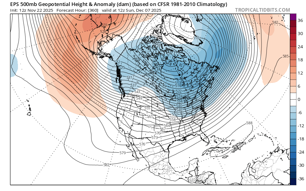
Do you know how hard it is for the EPS to show such a negative anomaly in the long range with our background state?

-
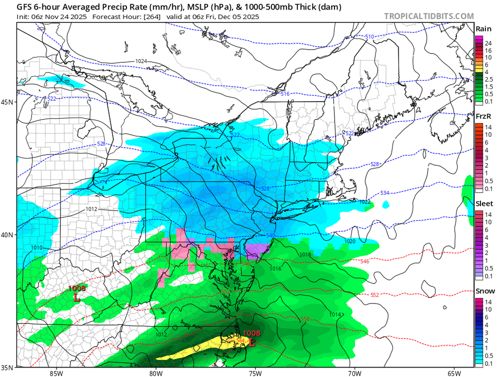
0z Euro was pretty cold for Thanksgiving weekend in NYC Mid 40s for Thanksgiving, low 40s for Black Friday, mid 30s for Saturday.
-
The 28th at the park averages 50/39
-
Something must be wrong, east edge of Queens is between 32 and 36 degrees. How can you still be at 40?
-
March 2018 has 8.4 inches at the park, 9.6 inches at LGA and 8.7 inches at JFK in a single event. I'm sure there are a couple other events that came close? 10 inch cutoff is arbitrary, nothing special about it. The cutoff could have easily been 8 inches or even 12.
-
I have thoroughly enjoyed this fall, ever since the first week of October we have had a great classic fall stretch with no nasty torches to kill the autumnal mood. The wind could have been lighter though, I have received an anomalously high number of texts from my wife saying, "why is it so fccking windy again" over the last several weeks lol
-
Lol what an absurd post, my god. 10 inches fell in Florida last winter, you think NYC can no longer get 4 inches in one event? There has been two events at JFK over 4 inches during this crap stretch, one of them being over 6 inches.
-
How much difference can there be between ground level and 2 meters? I remember when we had our burst of snow last week in the morning, my thermometer showed 33 degrees but I had a small puddle of water on a garden supplies container frozen.