

largetornado
-
Posts
126 -
Joined
-
Last visited
Content Type
Profiles
Blogs
Forums
American Weather
Media Demo
Store
Gallery
Posts posted by largetornado
-
-
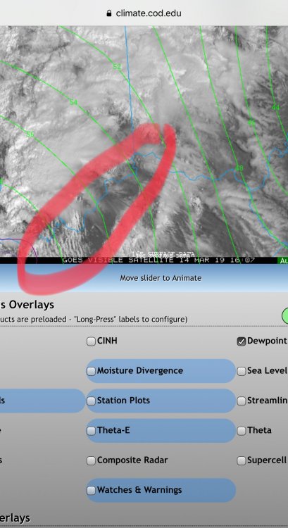
Models continue you to trend tomorrow’s system north. Not sure if separate thread is warranted. But latest models have significant sfc-1km srh values extending to i70 and Indiana is covered in UH tracks
-
 1
1
-
-
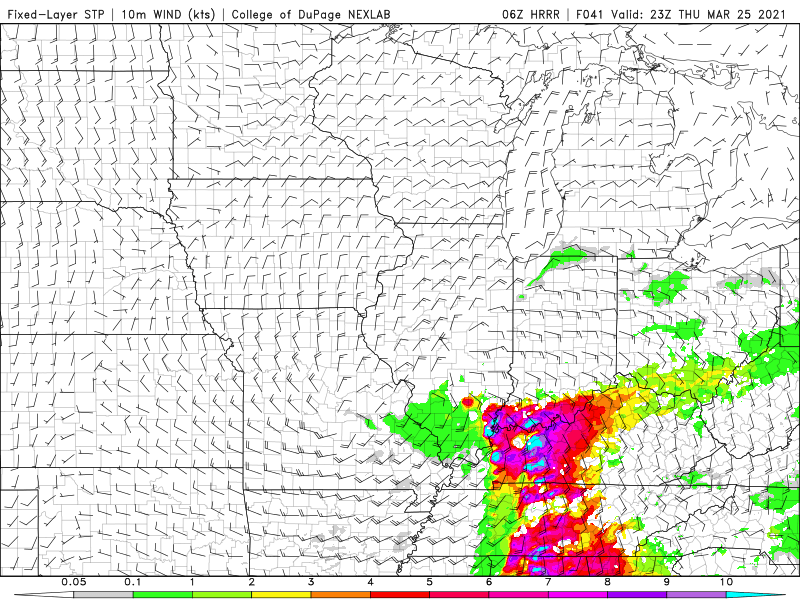
FWIW, it looks as if the threat to the southern half of subforum is growing for Thursday. 06z HRRR popped some significant STP values.
-
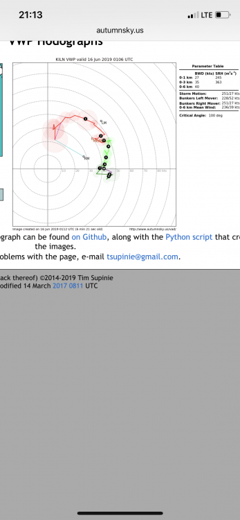
ILN vwp hodo
-
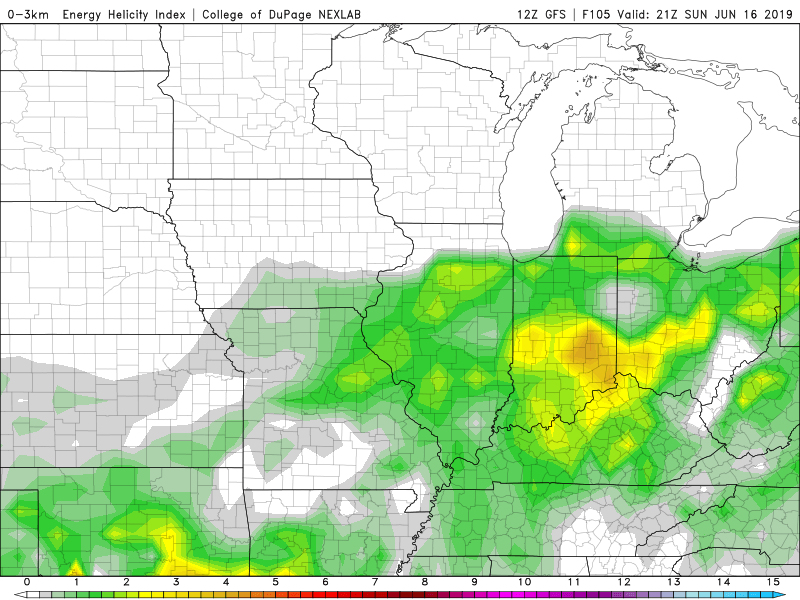
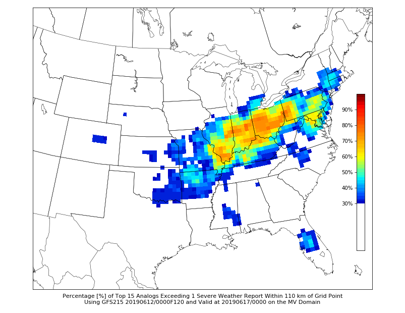
Sunday may be the first of a series of active days across the subforum.
Analogs have a few solid tornado events. (6/22/91, 6/6/2010, 6/4/2008)
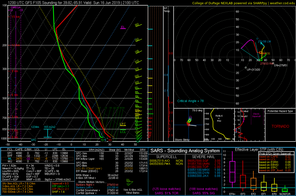
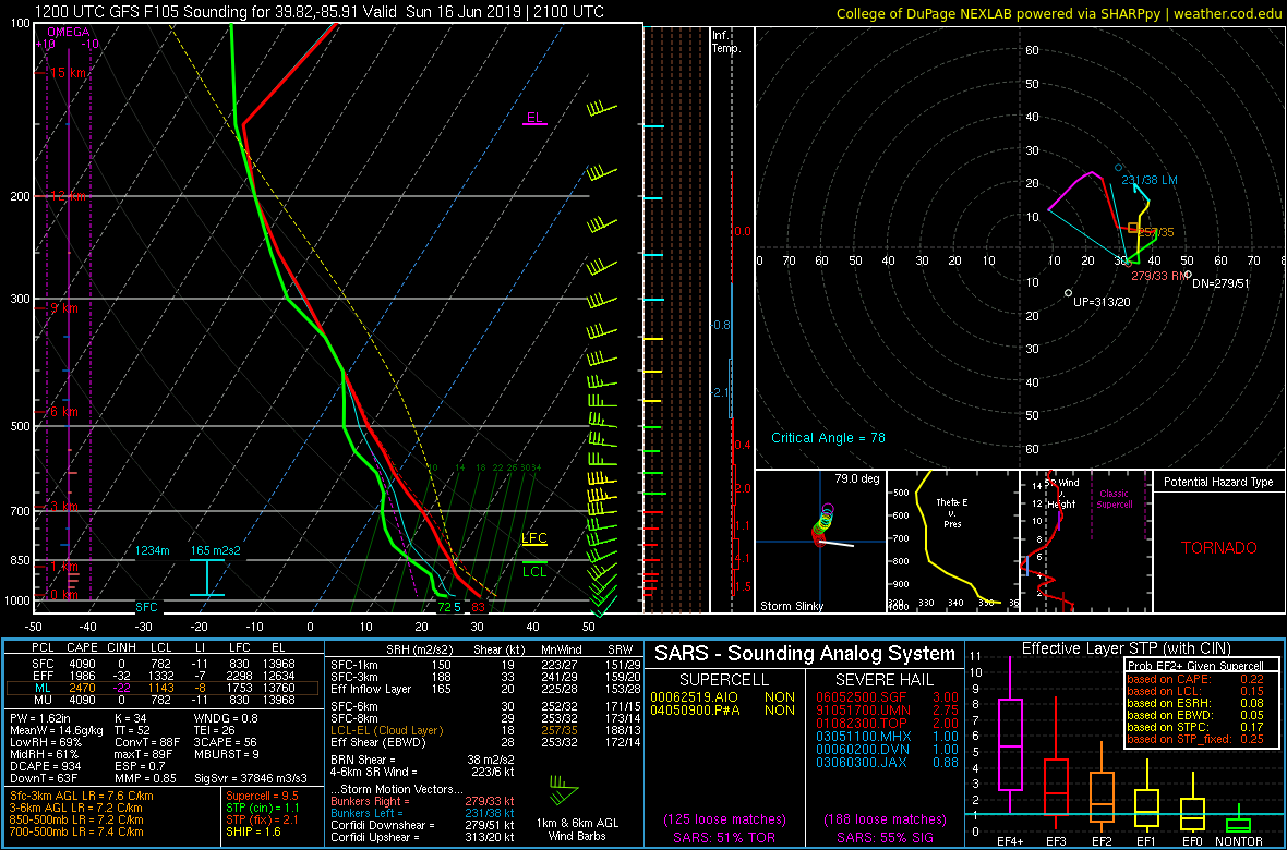
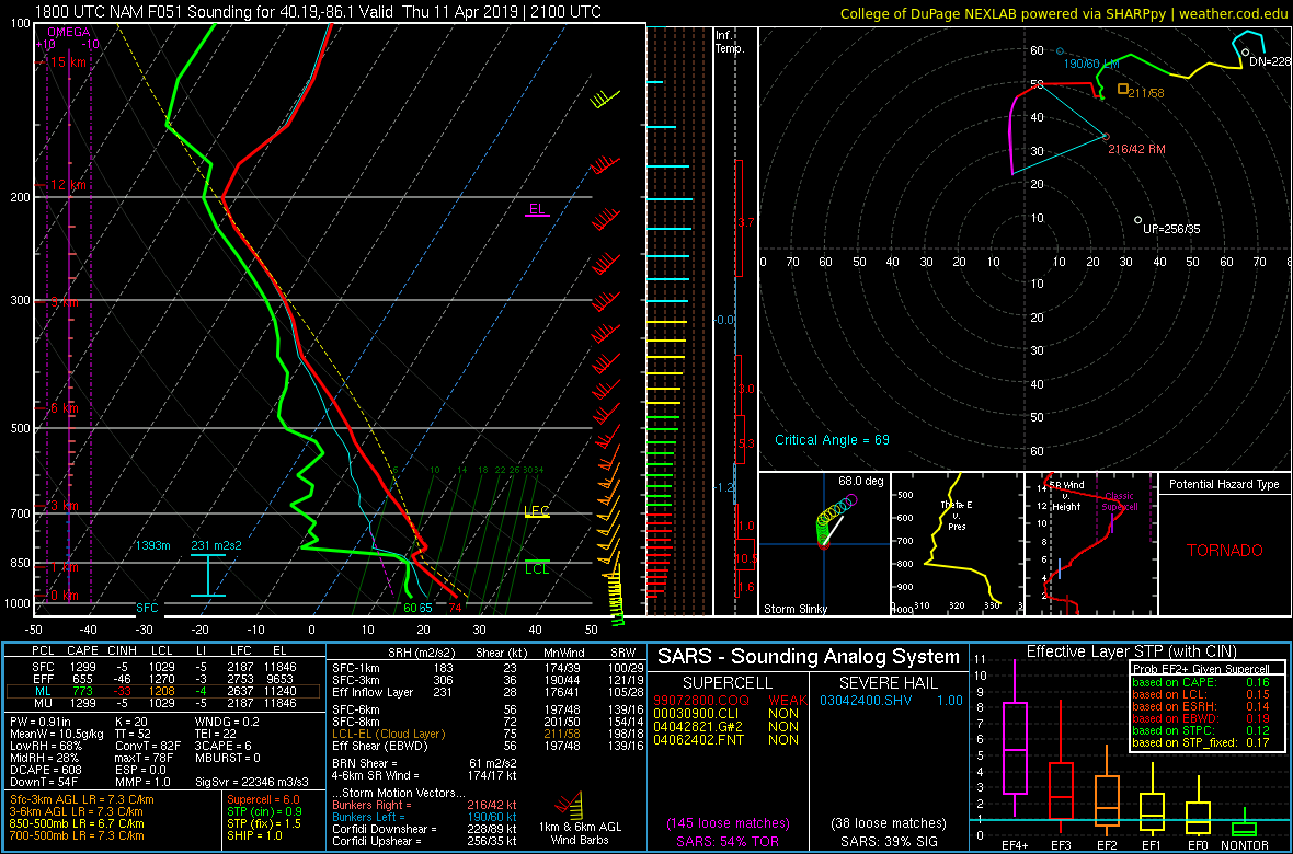
Sounding is from around indy at 21z. Not overly impressed with wind profile. Pretty veered at surface and highish LCL's.
-
I’m headed back east from my chasecation. Anyone see any reason to chase Se Kansas tomorrow?
-
I was out in the field today focusing on the storm I was on. I don’t know how much lead time they got, but that region is supportive of basements and most people have them. Hopefully cell phone alarms got people downstairs or to interior areas
-
-
Couple severe thunderstorm warnings in Kentucky. Surprised that SPC does not have out MD or watch.
-
Indiana has pretty good parameters tomorrow...Might be a late sleeper if stuff can form.
-
PDS Watch for Oklahoma issued. Wind/Hail/Tor probabilities all maxed out at >95%
-
Large part of the subforum under a marginal risk today.
 ...Ohio Valley/central Appalachians...
   Widely scattered thunderstorms are possible this afternoon, offering
   sporadic wind damage, with isolated severe (50+ kt) gusts and
   marginally severe hail possible.  A narrow corridor of favorable
   return-flow moisture should advect northeastward through the warm
   sector just ahead of the front, with surface dew points in the mid
   50s to low 60s F.  This will offset modest midlevel lapse rates to
   yield a field of 500-1000 J/kg MLCAPE for a few hours this
   afternoon, with surface-based effective-inflow parcels at least
   briefly possible as far northeast as western NY.  Low-level and
   deep-tropospheric speed shear should be favorable, though the
   prefrontal flow will be nearly unidirectional in vertical profile.
-
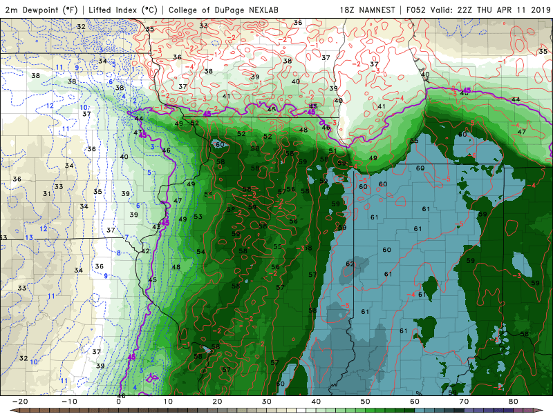
Mesoscale Discussion 0304
   NWS Storm Prediction Center Norman OK
   0313 PM CDT Thu Apr 11 2019

   Areas affected...Parts of northern and central Illinois

   Concerning...Severe potential...Watch unlikely

   Valid 112013Z - 112115Z

   Probability of Watch Issuance...20 percent

   SUMMARY...At least some increase in severe weather potential is
   expected  with developing thunderstorm activity across parts of
   northern Illinois by the 4-6 PM CDT time frame.  It is possible that
   this threat may remain low enough that a watch is not needed, but
   trends will be monitored.

   DISCUSSION...Near/just ahead of the lower/mid tropospheric cold
   front, forcing for ascent appears to be contributing to the ongoing
   increase in thunderstorm activity across northwestern Illinois into
   southwestern Wisconsin.  This activity is largely rooted above a
   near-surface stable layer to the north of the surface warm front,
   with relatively warm mid-levels and weak mid/high level lapse rates
   allowing for only weak CAPE.

   The band of convection is expected to gradually spread eastward
   during the few hours, with southward development into the warm
   sector of the surface cyclone also possible by 21-23Z.   Even within
   the warm sector, relatively low surface dew points across parts of
   eastern Missouri into west central Illinois are currently resulting
   in negligible boundary layer CAPE.  However, modest low-level
   moisture (reflected by mid 50s+ surface dew points) appears to be
   returning northward/northwestward in a corridor to the
   east/northeast through north of Springfield, into the vicinity of
   the warm front.

   A combination of at least weak boundary-layer destabilization along
   the warm front, coupled with increasing lift ahead of the occluding
   surface cyclone triple point (and associated eastward advancing band
   of mid-level forcing for ascent), may allow for at least isolated
   boundary-layer based storm development.  This seems most likely
   north/northeast of the Peoria vicinity, and may include one or two
   supercells accompanied by at least some risk for severe hail and
   localized strong surface gusts.  Although low-level thermodynamic
   profiles appear rather marginal, given the synoptic environment, and
   large low-level hodographs near/beneath 50+ kt southerly 850 mb
   flow, an isolated tornado may not be out of the question.

   ..Kerr/Hart.. 04/11/2019
-
1 hour ago, Hoosier said:
HRRR has some very nice warming in the warm sector tomorrow. Problem is it comes at the expense of dews mixing out.
There's a middle ground of temps being bit lower/dews a bit higher which wouldn't be such an instability killer like the above scenario.
FWIW, the HRRR is currently underdoing dew points in kansas by 3-4 degrees. Id probably add 2-3 degrees to the HRRR dewpoints for tomorrow.
-
 1
1
-
-
13 hours ago, Jackstraw said:
I'm skeptical on a lot with this system but hey it's something to break this lackluster beginning to Spring so far lol.

Can’t believe I’m taking a day off tomorrow. Warm sector has virtually no chance of activity and LCLs are around 850....
-
16 minutes ago, Hoosier said:
Nice to see a bit more moisture being progged. As was mentioned earlier, directional shear definitely lacking overall except right on the warm front. Speed shear looks tremendous though.
Sounding from near Danville, IL. Directional shear not terrible, but could be better.

-
18z nam and nam 3km both bring better moisture. I think question of warm sector activity comes down to sunshine. Right now, simulated IR is cloudy for most of the day.
-
Is it me or are these storms not moving east at all. Seems like the line has stalled and is just training. Would allow more time to destablize to the east...
-
Surprised by no upgrade to moderate.
-
2 minutes ago, BrandonC_TX said:
Eagerly anticipating the 1630Z SPC convective outlook. Some changes are bound to be made, especially for central and NE IL, plus NW IN, given the storms in that area.
Not to mention that clearing along the Ohio River is bound to introduce some issues down the line for Louisville and Cincinnati as well.Latest HRRR is handling the clearing well. Oddly, it doesnt destabilize much though. ~500 cape. Obviously enough for today, but I would have thought clearing would push to 750+
-
Just now, Wmsptwx said:
Wow...
And the hail threat was “low.”
Also concerned about sunshine along the Ohio river with a developing CU field
-
Just now, jojo762 said:
Not every day that you see several tornadic supercells at 10am with a 80/50 TOR watch already issued. Going to be interesting to watch this evolve. Not sure what ramifications these current storms will have for the potential in Indiana later quite yet.
With 600-800 effective SRH, any cloud breaks and destabilization will greatly increase tor threat. Watch out for the sun.
-
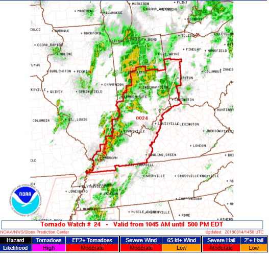
80/50 Tornado watch for Indiana/Ky/Ohio
-
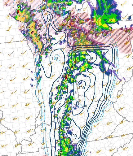
Currently, effective helicity is 350-400 in the tornado warned storm region. Forecast to hit 600-700. With 500 -1000 cape, thats more than enough.
-
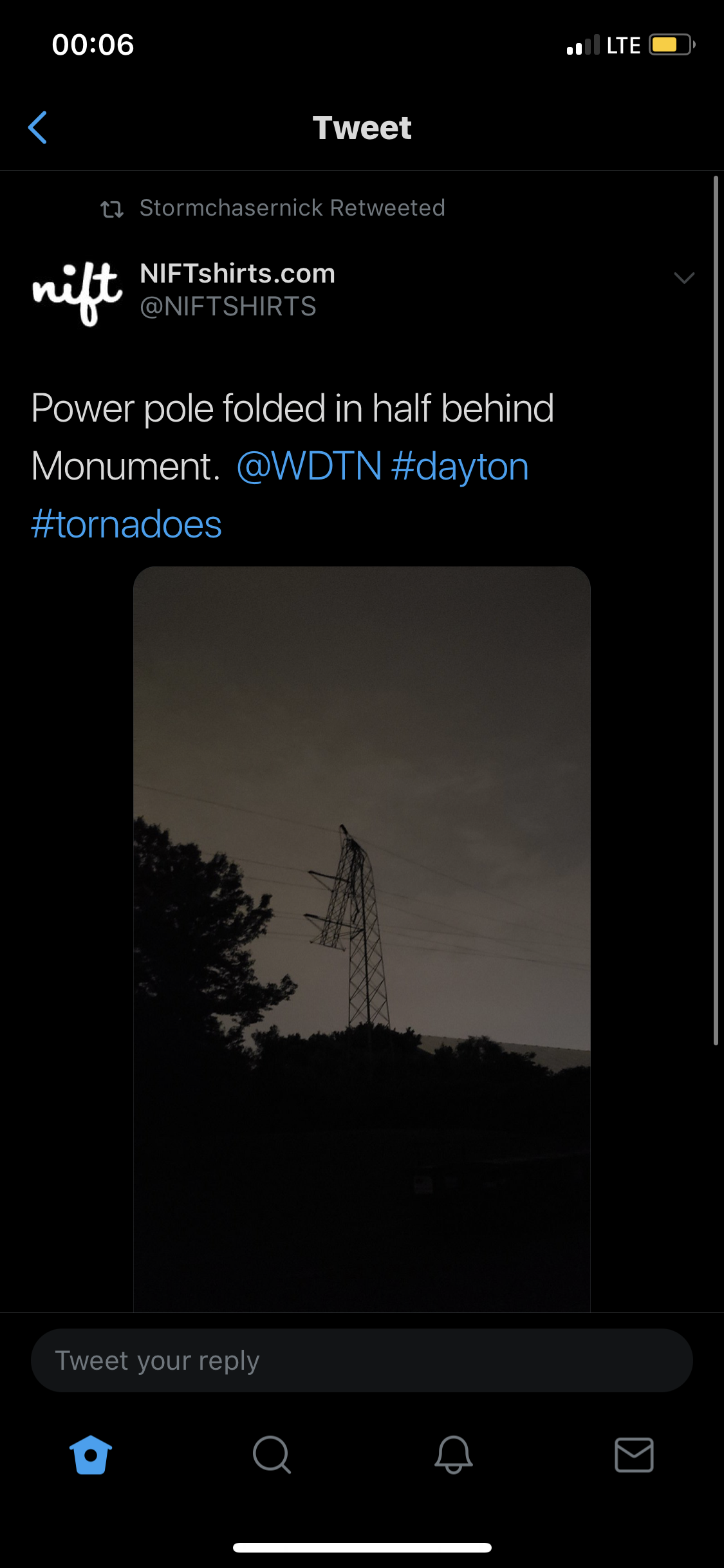
Third storm just went tornado warned


Severe Event March 25th 2021
in Southeastern States
Posted
I’m kinda curious why the storms aren’t spinning more. Srh of 400+ per mesoanalysis. Not surfaced based storms?