

largetornado
-
Posts
126 -
Joined
-
Last visited
Content Type
Profiles
Blogs
Forums
American Weather
Media Demo
Store
Gallery
Posts posted by largetornado
-
-
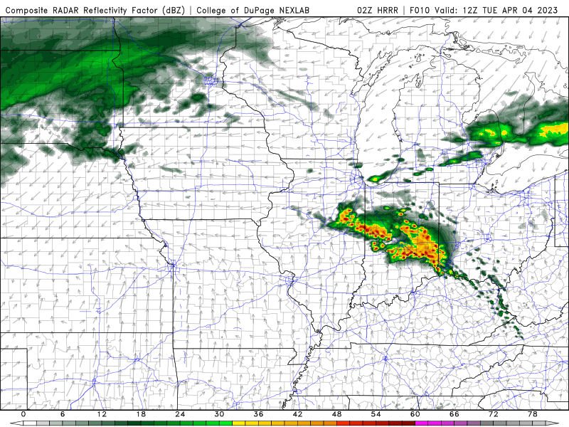
These storms around 12z…any chance they lay a boundary that interacts with the warm front as it lifts north and fire storms?
-
6 minutes ago, CheeselandSkies said:
I think the main things that's' not always conveyed is that oftentimes the sparser the storm coverage, the more dangerous the hazards can be from any one storm. Meteorologists & chasers know it, but EMs and the general public usually do not.
Bingo. What makes sense to us can and often times confuses the general public. IE, watch vs warnings.
-
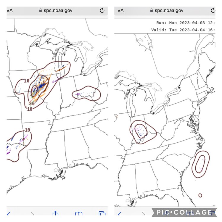
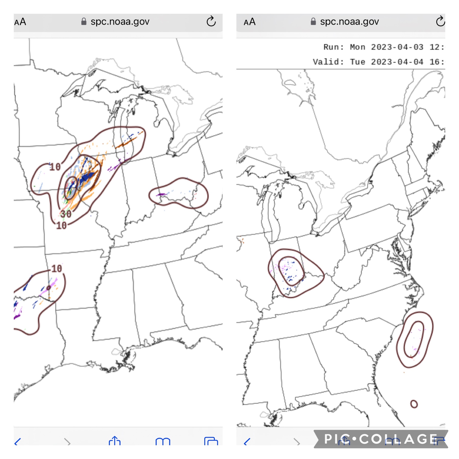
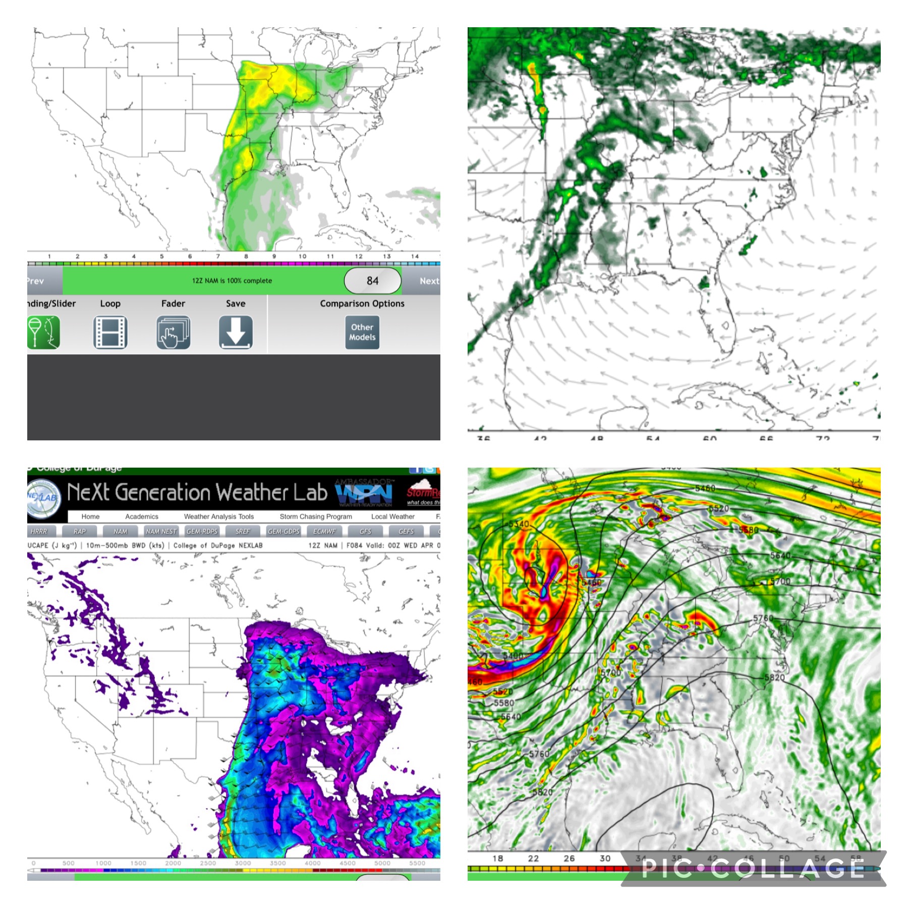
After looking at 18z, HRRR would have me chasing wednesday. If i went off the nam suite, i would not chase at all but its apparently been having problems this year. At this point, any storms that can become surface based will have a top tier environment to work with. I wish the SPC had a outlook that conveyed spatial coverage as well as potential intensity. Tomorrow would be a slight risk for storm coverage and a moderate risk for intensity IMO.
-
 1
1
-
-
19 minutes ago, bdgwx said:
12Z GFS isn't exactly what I'd call bullish with convection in SE IA, but it isn't devoid of it either.
The 12Z UKMET, OTOH, is actually pretty bullish with convection more so even than the 0Z cycle.
And the 12Z ECMWF continues to be bullish in this region.
I think given that I can't justify an argument against a moderate risk in the IA/IL border area.
FWIW, the HREF has a pretty bullish convective signal for Iowa/mo/ill area. Secondary, hinting at some early activity in Indiana south of i70
-
1 hour ago, Wmsptwx said:
Warm front is what to look at.
Yep. Warm front or very close to the triple point. Unless some subtle forcing mechanism occurs in the warm sector, it looks like it will be capped.
-
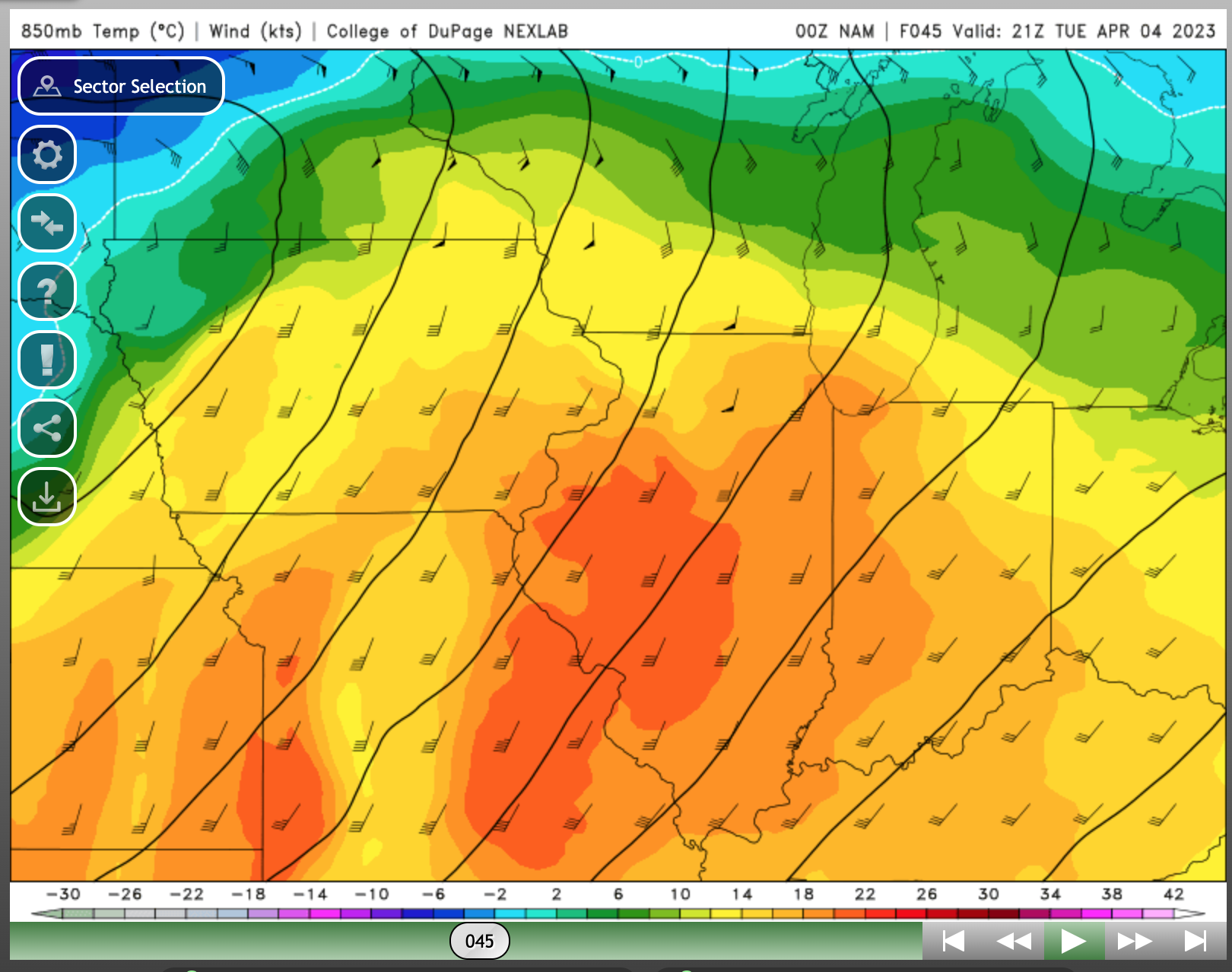
NAM has some ridiculous 850 temps. In my untrained eye, NAM favors cap bust. Nam 3km points to a cap bust/nocturnal threat, as someone pointed out HRRR is trending towards mixing issues.

-
HRRR isn’t shy
-
1
-
-
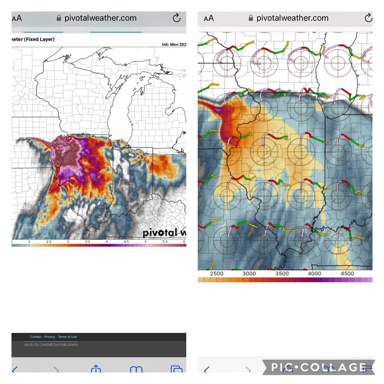
MUCAPE of 4500 per nam 3k at 18z tuesday. Lmao
-
1
-
 1
1
-
-
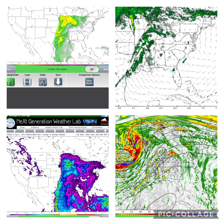
0z nam rolling in. Looks like a shift west
-
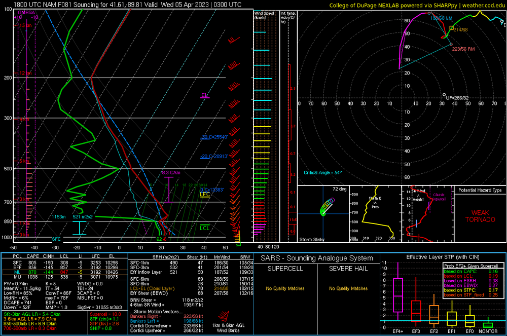
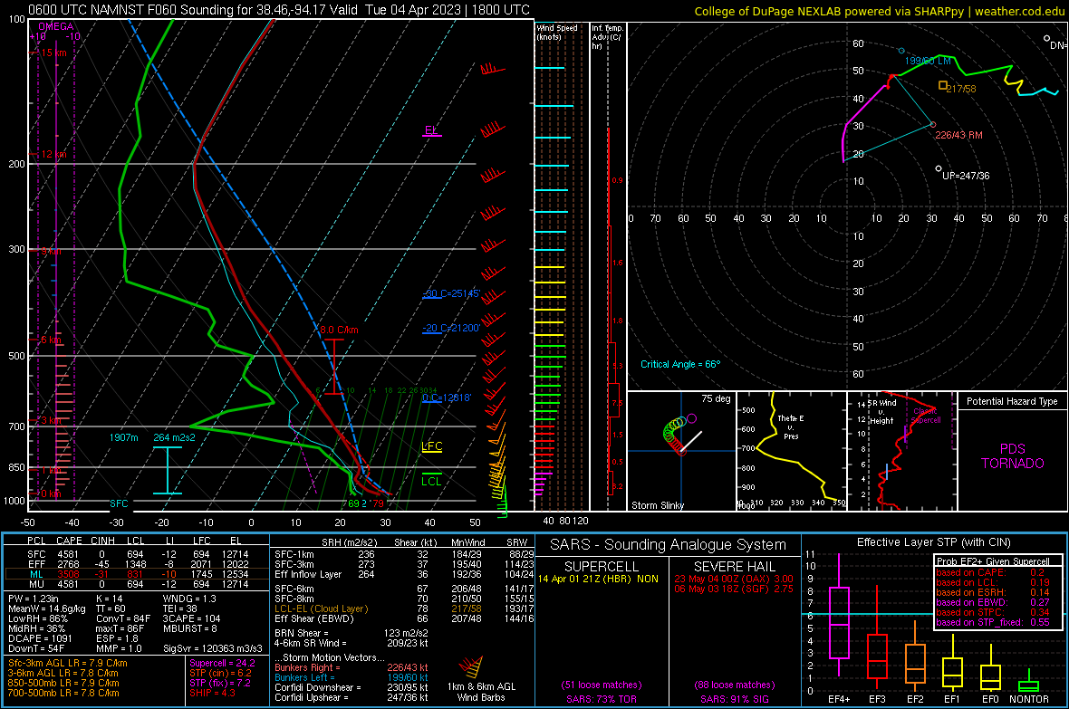
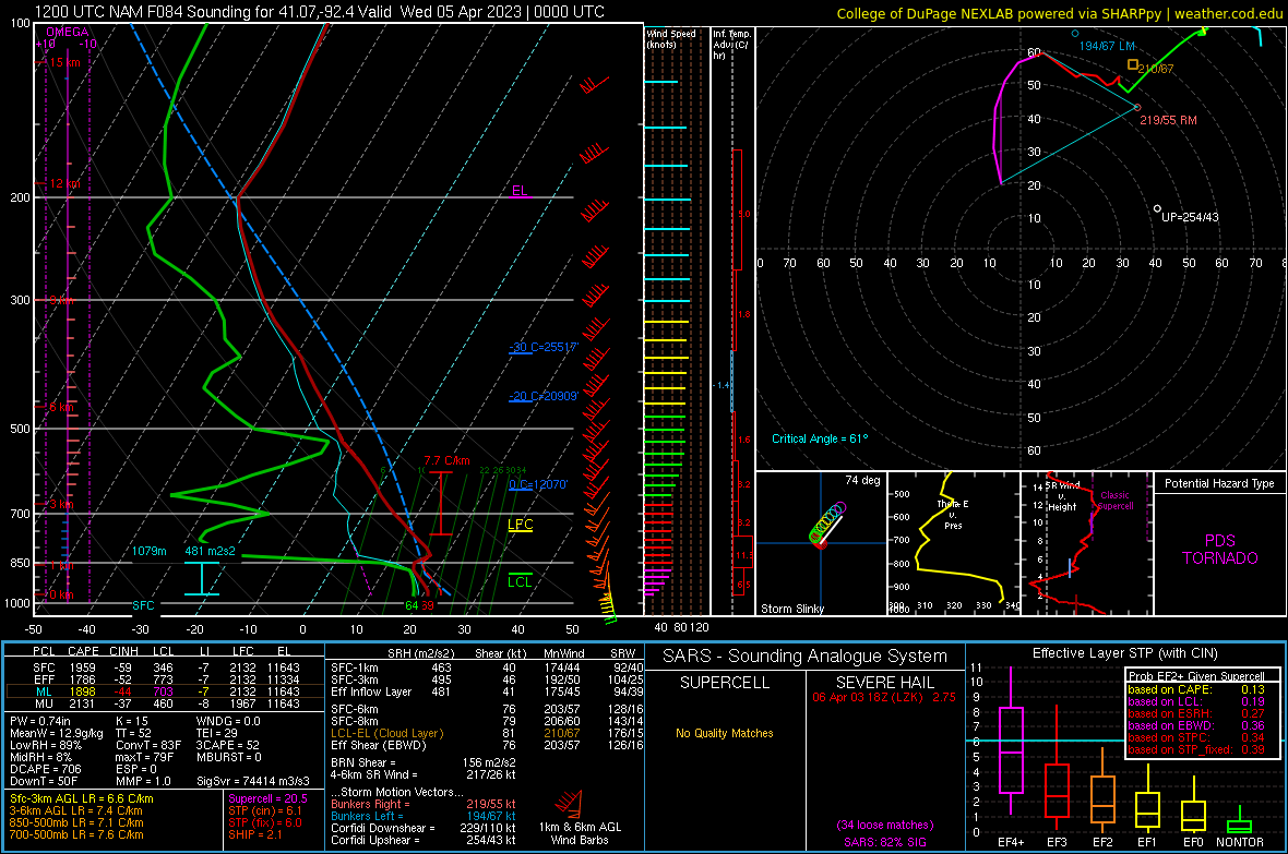
Looking through some soundings. Looks to be a fairly stout inversion right above 850. Failure mode?
-
Had some more time to look at the models. The warm sector is enormous with favorable parameters throughout. If the nam has its way, the warm sector is going to be relatively free of contaminating crapvection. (GFS and euro agree with the minimal rainfall in the warm sector as well) Good forcing throughout the warm sector…it certainly seems this could be a very high end event over a widespread area.
-
1
-
-
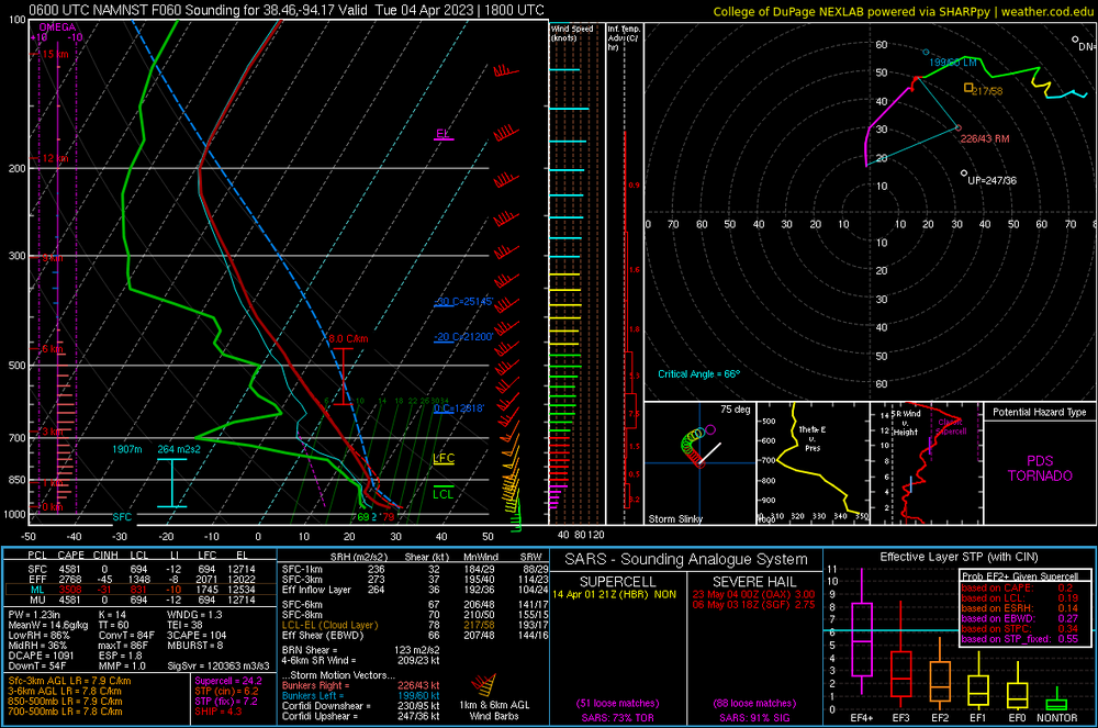
First sounding I picked from the NAM.
-
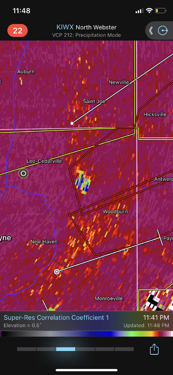
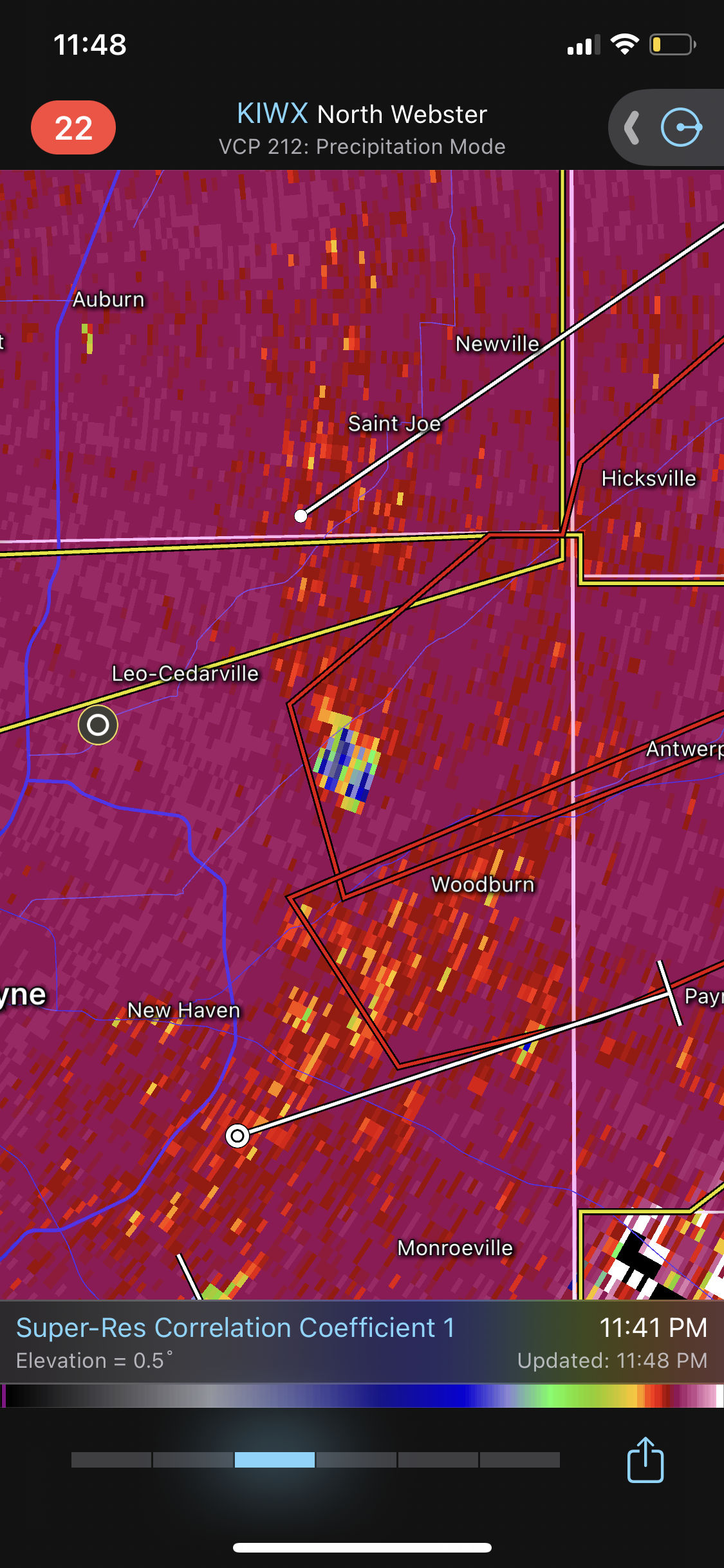
Tornado just dropped NE of Fort Wayne. Good debris ball
-
Just now, Tezeta said:
Property. Lol. Like half of us are straight up communists.
Where is McCarthy when you need him?
-
 1
1
-
-
The blatant disregard for life and property in this thread is appalling.
-
1
-
 3
3
-
 4
4
-
-
1 minute ago, 40/70 Benchmark said:
Its probably still trying to resolve some structural deficiencies that resulted from interaction with the higher terrain of Cuba.
Is it possibly the start of an eyewall replacement cycle?
-
1
-
-
160k without power in Cincinnati.
-
16 hours ago, nwohweather said:
There is some serious wind up and down this massive line. In Kentucky and Mississippi there’s for sure hurricane force winds
I ended up on 64 in shelby county kentucky. Pretty sure i was in a circulation but could not punch in front of the line as the winds were incredibly intense and visibility was all of 5 feet. I finally called it quits after being in it for a solid 30 minutes. Most intense driving ive experienced. One hell of a storm. And FWIW a mesonet station in Shelby county recorded a 75 mph gust
-
38 minutes ago, andyhb said:
I know, I just posted that for the receipts
Also they apparently rated this EF2? Huh?
The bottom sill plate is missing and broken in places. I also saw another post where an anchor bolt was visible in a CMU foundation but survey noted “no connection.”
this survey is bogus.
-
1
-
-
17 minutes ago, Buckeye05 said:
No NWS office is going to question Tim Marshall. Rating is pretty much locked in now.
Tim mentioned vehicles on his Facebook. That’s a joke. The average new vehicle is heavier and more aerodynamic than in the past. This is a poor rating
-
1
-
-
1 hour ago, Normandy said:
Upon closer inspection of this photo, I do not see the rebar within the pieces of concrete (you would see them sticking out the edges). That being said there is ample evidence that this was EF-5
I AM NOT DISCOUNTING THE DAMAGE. However, that concrete work was improperly done. They didn’t pull the rebar up and it basically sat at the bottom of the pour (if they pulled it up, no way that concrete breaks like that or there would at least be evidence of the rebar in the concrete). In other words, that rebar provided little if any strength) I’m very curious where the hell that rebar grid went as post tornado pictures just show gravel.
-
1
-
-
1 hour ago, Hoosier said:
I wouldn't be as definitive as some are, but I think it's greater than 50% chance of it being EF-5. I am probably more interested in whether it broke the Tri-State tornado record for path length. That is almost an unthinkable record in my book. It's like DiMaggio's hitting streak being broken.
Reed timmer posted a video from someone showing it as a wedge on approach to the Mississippi River. He tweeted “likely 1 tornado”
-
8 dead, 8 missing at candle factory. Not 70 dead like early estimates per AP and candle factory spokesman
-
2
-
-
29 minutes ago, dan11295 said:
https://twitter.com/bclemms/status/1469815153780793347
Footage of Dawson Springs, KY. pop ~2500. Also hit directly by the long track tornado that hit Mayfield. High end damage.
Completely leveled. Insanity

Severe Weather 4-4-23 and 4-5-23
in Lakes/Ohio Valley
Posted
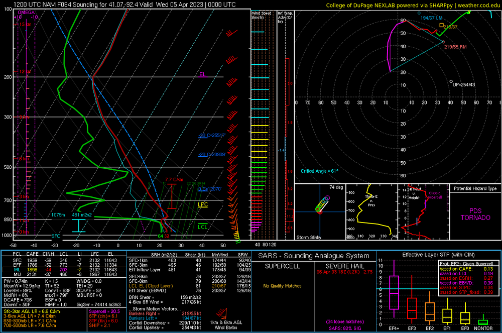
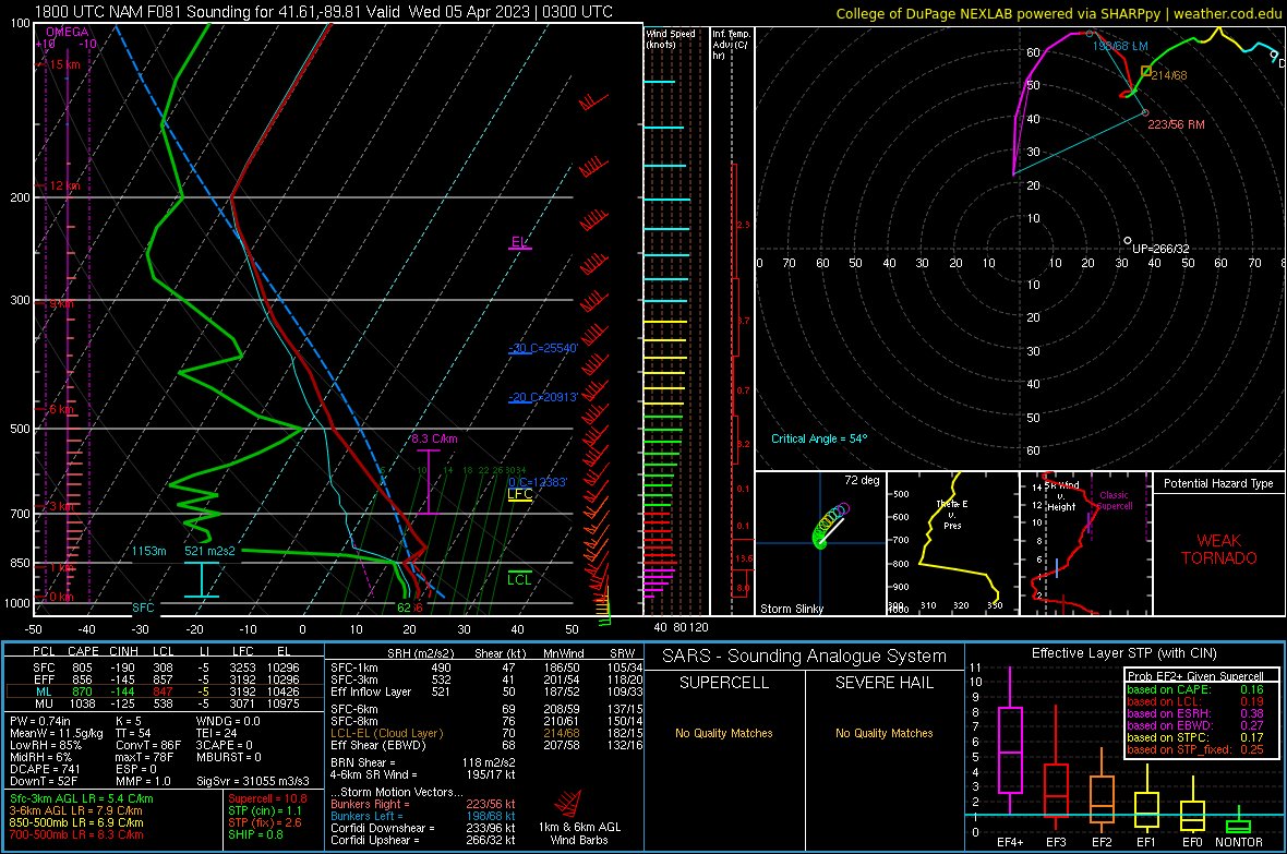
For whatever reason, the warm front, as it lifts over central Indiana has me really intrigued .
(also I think I found the tightest hodo for a PDS TOR Sounding)