purduewx80
-
Posts
1,705 -
Joined
Content Type
Profiles
Blogs
Forums
American Weather
Media Demo
Store
Gallery
Everything posted by purduewx80
-
Good luck with a national mask law. Public shaming/cancel culture seem to be making progress. If that won’t work, more lockdowns will do the trick.
-
new study in Nature today:
-
oh i definitely understand, but what can i say? freedom isn't free. all of what you describe is more a disruption to capitalism than anything else. it's what we have to figure out how to deal with now.
-
I caught it back in March when I still lived in NYC, most likely from community spread. At the time, it was unclear what was going on because we weren't aware of all the symptoms people were experiencing. Never had a fever or cough. I was fortunate to not have it as bad as some, but I was still sick for almost three weeks. The most alarming symptom for me was having zero sense of smell. My boyfriend did not fare as well, but he made it out ok, too. I'm still wearing a mask when in public since we don't actually know how long immunity lasts, or if everyone even becomes immune. It feels important to normalize wearing masks in public because that is literally our best bet to get past this. It's unwise to assume you won't catch it in your small towns (which by the way are adjacent to busy interstates with restaurants and gas stations you may use, no?), especially with folks traveling more now. The only thing I fear personally is further economic collapse caused by the entirely preventable spread of this virus. I suspect we should remain concerned about our shitty healthcare system becoming overwhelmed, too.
-
This was the entire point of my so-called "baiting". Thank you for explicitly stating it. Wear a mask. Normalize it until this is over. edit to add that opening the entire economy up now is obviously ill-advised after the recent surge in cases.
-
Unabridged capitalism and our modern “need” for immediacy will obviously not work with everything going on. There may be some happy medium between short-sighted open-everything-now and careful, long-term planning to get us through all this, but we can’t just assume a vaccine that doesn’t exist yet or herd immunity are going to work. There’s a shit ton we still don’t know about it. I’d loooove to know how many of the people in favor of letting old folks die consider themselves pro-life.
-
This thread about how masks prevent droplets from escaping during speech is wonderful. It's all hard science, easy to follow and not anecdotal. https://threadreaderapp.com/thread/1274036544387477504.html
-
yes, they absolutely are.
-
IL requires them in public spaces when you can’t social distance, so maybe that’s why? Most airlines are requiring them on the plane, but not sure how that works in airports since they’re a mix of federal, state/local and private property.
-
There is literally no point in arguing with pig-headed science deniers. Let them live their fearless, ignorant lives.
-
beavis for prez.
-
-
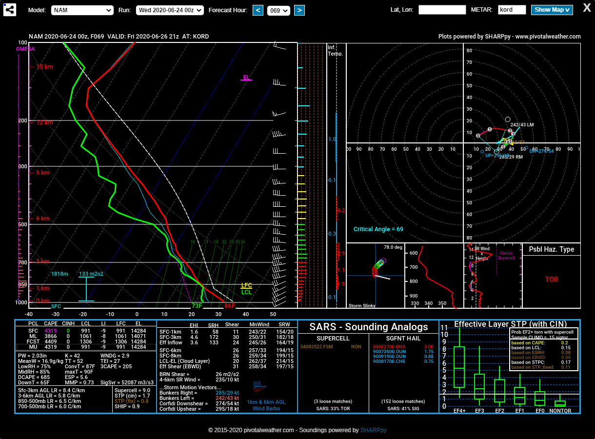
Friday looks interesting. Strongest 700-500mb flow is across WI and lower MI. Lapse rates are on the meh side, but instability is more than sufficient for severe given the progged shear. This should result in some bowing segments ahead of the front.

-
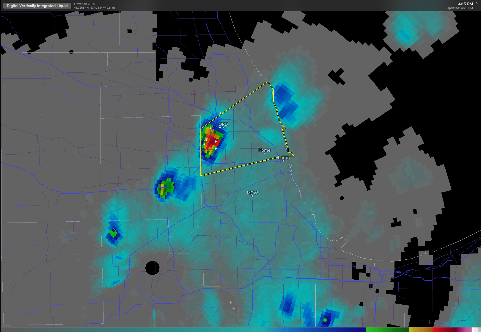
new cells blowing up quickly on the outflow boundary from that first round. warning for northern Cook...looks like some hail in that too.

-
Not 100% sure what you mean. I can't say for sure, but I imagine the 50+ crowd is taking more precautions. Hopefully with their children and grandchildren, too.
-
exactly...keep those cases up through summer, and wave two will be so much more widespread come fall. i would imagine (and hope) we'll see more mask requirements at the state level in the short term.
-
https://www.cnn.com/2020/06/22/health/covid-younger-adults-lower-death-rate-trnd/index.html
-
-
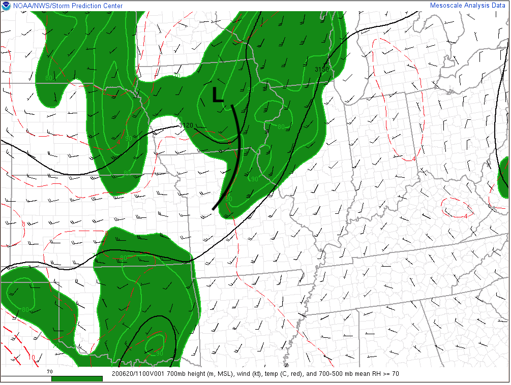
looks like a decent chance of storms around here by midday or early afternoon. nice 700mb wave coming in with ample sun ahead of it. drier dews could allow for some pulse type, outflow-dominant activity. the lucky ones will probably see 2-3 rounds today according to most of the latest hi-res.

-
Nailed it. July 4th and the 1-2 weeks after should be interesting given tomorrow’s Tulsa experiment.
-
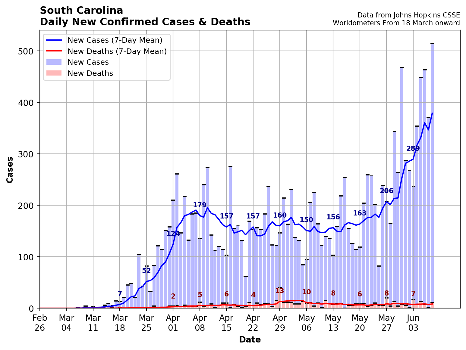
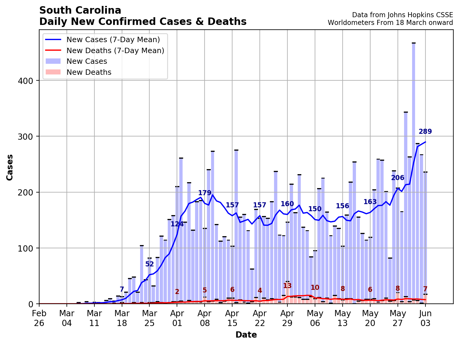
But it doesn’t according to at least one state epidemiologist. “Early on, South Carolina took the essential steps needed to flatten the curve,” Alberg said. “The problem has been re-opening too soon, which has led to a very large upsurge in COVID-19 cases that cannot be accounted for solely due to the increased testing for active SARS-CoV-2 infections.“ https://www.thedailybeast.com/is-south-carolina-already-on-a-second-wave-of-covid-19?ref=scroll
-
Probably a little too soon to be blaming protests. Wouldn't see anything from that until later this week or early next. Other states that opened early are also seeing spikes, though Georgia is somewhat perplexing.

-
http://arctic.som.ou.edu/tburg/products/covid19/

-
Agree a slight risk upgrade would've been reasonable given an enhanced risk ceiling across a small corridor. I like the overlay of shear and instability across northern and possibly central IL. Chicago is likely in play too given early AM fog will clear quickly.