

midatlanticweather
-
Posts
4,634 -
Joined
-
Last visited
Content Type
Profiles
Blogs
Forums
American Weather
Media Demo
Store
Gallery
Posts posted by midatlanticweather
-
-
The outflow boundary from storms earlier to the west of Loudoun pretty much seems to have sucked the life out of anything new forming. Guess more activity could spring up. Maryland looks a bit busy and other parts of the area
-
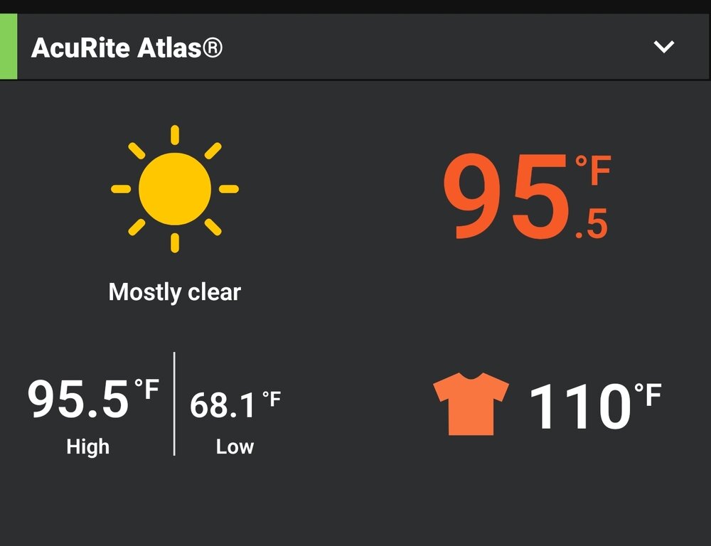
HI here hit 114 in the last hour but it has fallen. Temp is up to 93.5 degrees and a HI of 107 - Seems the Convective temps have been hit based on the puffy clouds and the look on radar! We shall see.
-
43 minutes ago, Terpeast said:
Yeah its only June. Plenty of time for another ridge to build over the top.
I do not care that we allow other curse words, this is some messed up stuff!

-
98.3 was the high today, and high for me for the year! DP is 74.. this is better than yesterday!
-
Good grief!! DP is up to 82!! HI is 118. At 7:33 the HI was 121 degrees!
-
WOW! Air you can wear out there!
12:15pm - 92.5 degrees, 79 degree dp, HI shows a 111!
NASTY!
-
 1
1
-
-
Dude.. Nasty out
-
1
-
-
4 hours ago, dailylurker said:
There's trees and power lines down in Crownsville. Cops had roads blocked due to power crews fixing downed lines.
https://twitter.com/JackRuddenWX/status/1935453965287563439?t=9P-lzI_DxAwTKsOFYJdS_w&s=19
-
1
-
 1
1
-
 1
1
-
-
-
-
Meant to post here. Despite it being on x
https://twitter.com/DylanFedericoWX/status/1933292069834948947?t=_k5Uu-35wyMSNNeieTOJlw&s=19
-
Looked good for a bit. This was back about 15 mins ago

-
2
-
-
Thursday starting to look a lot different on models. Heat getting muted by clouds and easterly winds?
-
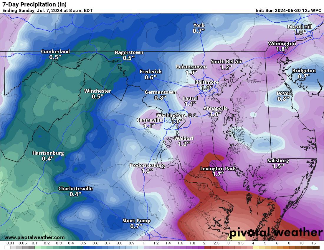
WPC is still pretty good on precip over the next 7 days. GFS backed off. The Euro still pretty wet.


-
2
-
-
44.3 for the low in Purcellville
-
1
-
-
3 minutes ago, yoda said:
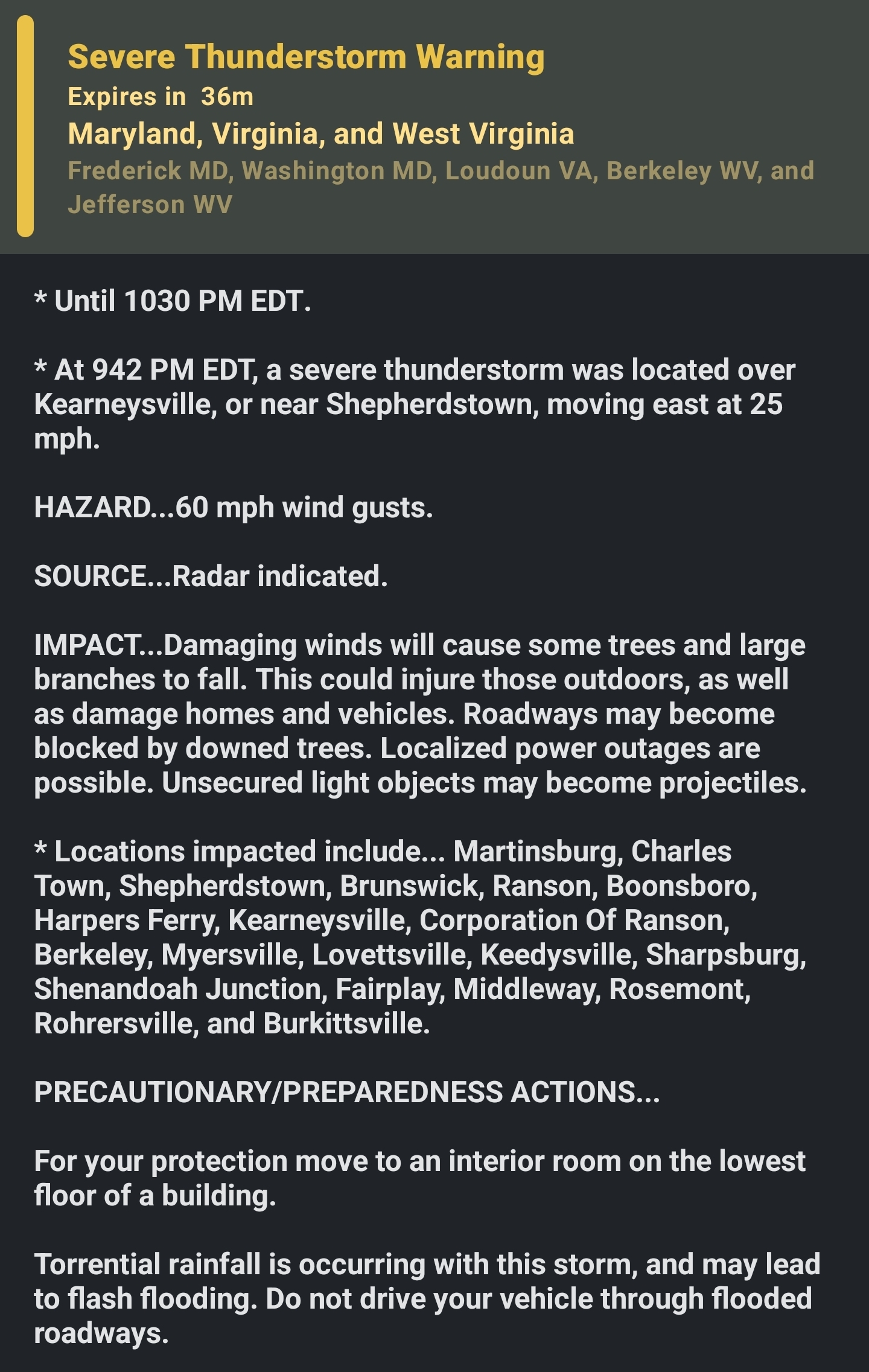
BULLETIN - EAS ACTIVATION REQUESTED
Tornado Warning
National Weather Service Baltimore MD/Washington DC
550 PM EDT Fri May 30 2025

The National Weather Service in Sterling Virginia has issued a

* Tornado Warning for...
  Southern Shenandoah County in northwestern Virginia...
  Central Rockingham County in western Virginia...
  Southwestern Warren County in northwestern Virginia...
  Northern Page County in northwestern Virginia...
  West central Rappahannock County in northwestern Virginia...

* Until 630 PM EDT.

* At 549 PM EDT, a severe thunderstorm capable of producing a tornado
  was located near Mount Jackson, or 16 miles southwest of Woodstock,
  moving east at 40 mph.

  HAZARD...Tornado.

  SOURCE...Radar indicated rotation.

  IMPACT...For those in the direct path of a tornado touchdown,
           flying debris will be dangerous to those caught without
           shelter. Damage to roofs, siding, and windows may occur.
           Mobile homes may be damaged or destroyed. Tree damage is
           likely.

* This dangerous storm will be near...
  Luray and Mount Jackson around 555 PM EDT.
  Sperryville around 615 PM EDT.

Other locations impacted by this tornadic thunderstorm include
Kimball, Kings Crossing, Compton, Shenandoah Caverns, Leaksville,
Hamburg, Fourway, Quicksburg, Fairview, and Bentonville.

PRECAUTIONARY/PREPAREDNESS ACTIONS...

TAKE COVER NOW! Move to a basement or an interior room on the lowest
floor of a sturdy building. Avoid windows. If you are outdoors, in a
mobile home, or in a vehicle, move to the closest substantial shelter
and protect yourself from flying debris.

&&

LAT...LON 3861 7874 3872 7878 3885 7829 3865 7820
TIME...MOT...LOC 2149Z 256DEG 36KT 3867 7867

TORNADO...RADAR INDICATED
MAX HAIL SIZE...<.75 IN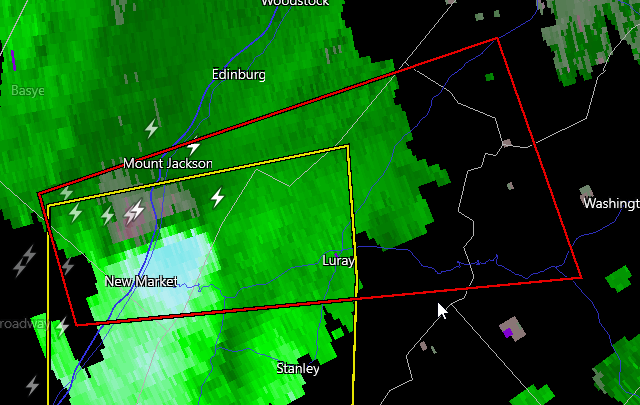
-
 1
1
-
-
Just now, yoda said:
Tornado Watch coming soon for western part of the CWA

-
1
-
1
-
-
3 minutes ago, George BM said:
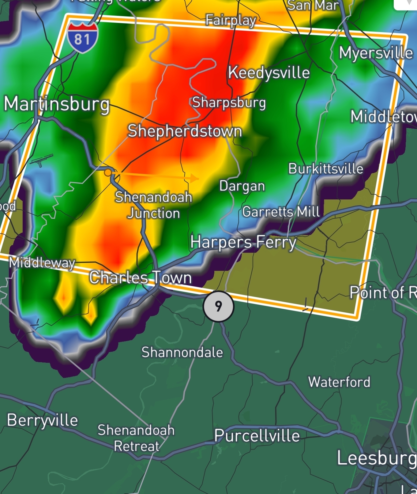
Lol 13z HRRR is loltastically aggressive with a sting-jet feature overnight bringing 50-60mph wind gusts from northern VA through DC and southern MD...
No I don't see it getting THAT windy.

NAM looks gust this evening as well. I could see some wind advisories for higher elevations being possible.. Would not be surprised for Piedmont as well.
I know models can overdo it many times and what actually gets to the surface can be less. Breezy seems likely - how windy is questionable.

-
1
-
-
-
What an awesome morning walk! WOOT WOOT! Was only down to 49 in MBY, but was a great way to start the day!
-
1
-
-
1.94 inches here. Few spots vert close by have had almost 2.5 inches. That may be more convective rain firing and headed for Loudoun. Not super organized yet.
-
20 minutes ago, frd said:
First wave of steady rain moving up from lower Delaware. Rather humid outside this morning seems warmer than the air temperature.
The air is thick with humidity - for sure! Rain was more here than thought! Stupid weather station keeps messing me up! .44 inches so far! That is good stuff! Some stations less than 2 miles away are approaching an inch already!
-
3
-
-
.18 so far. 64.5 degrees. As my late dad would say "If it keeps clouding up it is ginna rain!" Every storm... Especially Thunderstorms
-
1
-
-
Only .2 inches overnight. Nothing yesterday. Not the rain we needed here.
-
1
-

June Discobs 2025
in Mid Atlantic
Posted
I was out mowing and that storm was pretty far away when a bolt hit right next to my neighbor's home. Wild. I stopped mowing. The storms were even further than when I took this screen grab. Blue sunny sky with storm clouds a bit in the distance. Got my attention!! Lol