

SnowtoRain
-
Posts
753 -
Joined
-
Last visited
Content Type
Profiles
Blogs
Forums
American Weather
Media Demo
Store
Gallery
Posts posted by SnowtoRain
-
-
Just means the air is moistening up. But if it keeps going they will drop the WSW and put out heat advisories...
-
 1
1
-
-
6 minutes ago, PrinceFrederickWx said:
My temp/dew actually went up, from 28/19 a few hours ago to 30/21 currently.
Yeah mine has gone up 3 degrees from 23 to 26, I think that is happening most places.
-
 1
1
-
-
Good luck everyone, I hope the WAA treats us well.
-
1
-
-
23.5/16.5, seems the RGEM has the cold modeled the best for the Eastern Shore not sure how it looks elsewhere. NAMs were around 30 at this time.
-
4
-
 1
1
-
-
25.7/16.3, one thing we do well is radiational cooling
-
36.5/15.6 on the shore.
-
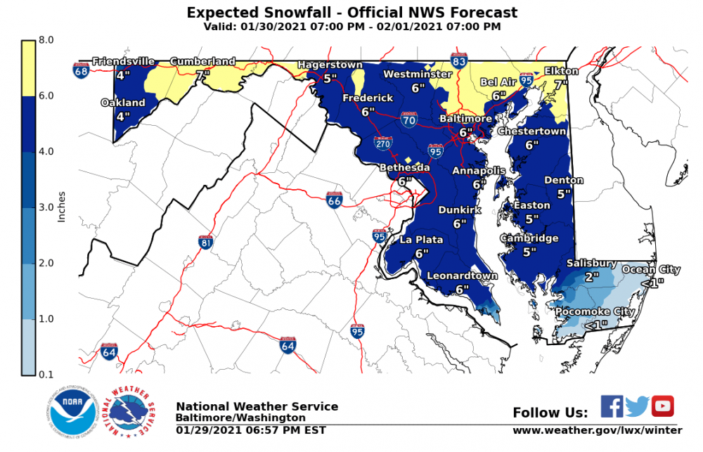
Forecast wise not much has changed for our region it seems, best WAA Charles, N. St Mary's and Calvert with less totals farther north and east. Most of our snow will come then so hopefully we can capitalize on some more moisture at the beginning. Biggest boom or bust is @CAPE and @JakkelWx neighborhood.
-
2
-
-
27 minutes ago, Wxdavis5784 said:
You gotta admit it’s comical watching the weenies live and die by each run...
Honestly it comes full circle 4 or 5 days ago we were having similar solutions with the coastal crushing the Northern part of our forum and then the suppression started, everyone (psu et al) panicked and now we are back where we started. I said 1"-4", snow to rain to dry slot for our sub forum at large a few days ago and these diamond hands are sticking with that. We might get some upside with WAA for Charles, St Mary's, and Calvert, but here on the shore the bar is at 4" for midshore and @Lowershoresadness the bar is seven snowflakes.
-
1
-
-
Just now, frd said:
OMG
.png.65a7ba373c3b27d38cea726c4938f332.png)
RGEM has been doing that, 2 runs ago @CAPE was getting 24"
-
1
-
-

posted in many sub, but relevant here, current projections fairly even, once the coastal is better modeled this will change
-
1
-
-
-
30.6/16, seems the NW across the bay keeping temperatures from dropping quicker. High of 34.
-
WAA looks good for Charles, St Mary's, and Calvert folks. Hopefully that juice makes it across the bay.
-
2
-
-
With the midday runs , I think my forecast from earlier still stands 4" to rain to dryslot.
-
So how accurate has the RGEM been recently?
-
5 minutes ago, alexderiemer said:
You know one of these times its actually gonna snow and all you Debs are gonna look kinda silly.
Sent from my SM-G975U using Tapatalk
Until that time comes who is the silly one...
All jokes aside I think we have all seen enough of these storms to know the usual outcome. The last storm greater then 10" was 2016 where we all waited for the deform band to swing through as advertised and we know what happened. That storm I ended with 11" of snow and 2" of sleet almost all from WAA. Generally, these WAA to coastal type storms have not been the most friendly in recent years, any sniff of ocean air destroys our thermals pretty quickly and then we sit in sinking air as the coastal spins up.
-
1
-
-
3 minutes ago, Lowershoresadness said:
If the Euro keeps heading south we may get a surprise. My expectations ,after a week of tracking this storm, are 0 inches.
Partly cloudy skies throughout our region while Cape Charles gets buried under 12" of snow and your 0" forecast still verifies.
-
1
-
-
I think I'm sticking with 4", transition to rain, and maybe 1" from coastal as it wraps back in some colder air.
-
1 hour ago, PrinceFrederickWx said:
IMHO if we're going to do this IMBY, it's gonna have to be the front end thump- that was really the difference between a 2016 HECS and a 2014 fail. I don't put much faith in the backside or the coastal part- 2019 was really the only one I can remember that overperformed on the back end, but that system was further south anyway I believe.
NAM supports your assessment of the front end thump to light rain to dry slot. Does not go far enough out to see what the coastal does, but I would guess that with the NAM's evolution that will probably be minor for us. Again, this is the NAM at the end of its range so obviously many caveats, but the last two storms the NAM did sniff out the general evolution (QPF aside).
-
1
-
-
-
Euro put out more snow, but the surface temps get to >35 by hr 90 and stay above freezing for most of the remainder of the storm. Unless I misinterpreted something that is still fairly marginal.
-
2
-
-
34 minutes ago, PrinceFrederickWx said:
This just has fail written all over it for Southern MD and lower shore.
Not sure if this is really a fail since it was never a setup that would generally (there have been a few exceptions) give us much snow to begin with. From the models so far today it seems like 1-4" before transition to rain and then maybe a few snow flakes on the backend if we are lucky. So that is where my bar is set for this one. I think anything less then that would be a fail so with that low bar we should have good boom potential if the costal trends southeast more.
-
1
-
-
15 minutes ago, Lowershoresadness said:
too early to bail but nothing I've seen so far excites me. In a cold winter we need everything to go right. In this winter we would need dumb luck.
You might get some mood flakes down there tomorrow, most mesos have some snow reaching up to Dorchester
-
Can't say any of the current solutions look that great for our region, although I will reserve judgement until all of tomorrow's model runs since just yesterday everyone was panicking that the storm was going to be suppressed.


Jan 31st - 33rd Storm Obs and Disco like it's 1979
in Mid Atlantic
Posted
Dew points are rising in response to the storm and temps are reflecting that. PHL probably still has dry air.