

Albedoman
-
Posts
848 -
Joined
-
Last visited
Content Type
Profiles
Blogs
Forums
American Weather
Media Demo
Store
Gallery
Posts posted by Albedoman
-
-
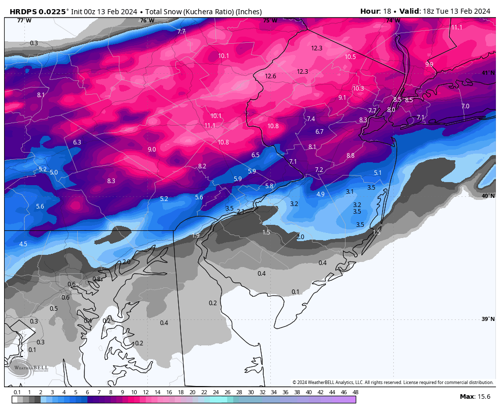
2-4 with lollipops of 5 in eastern pa Mt Holly good call When the 3 match up in 24-36 hours it works
-
 2
2
-
-
-
-
-
10 hours ago, Albedoman said:
yep, I agree . Its show time for the HRRR with the 00Z runs which should drop the hammer with WWA lifted all the way to the LV by morning
true to form. WWA just issued for the LV
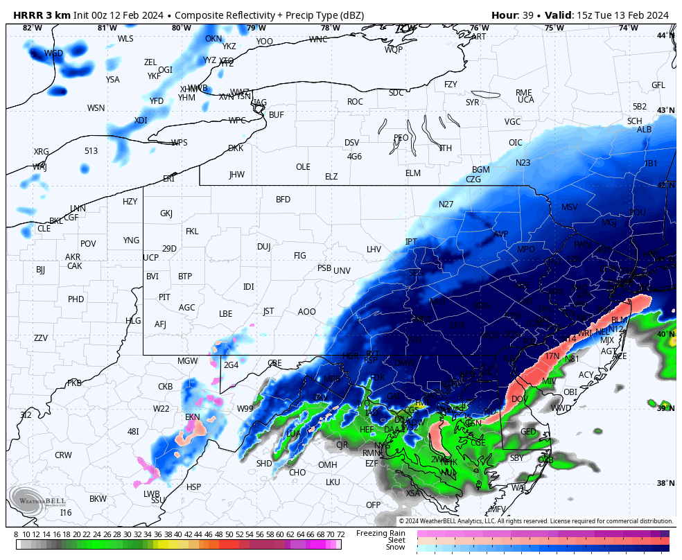
URGENT - WINTER WEATHER MESSAGE
National Weather Service Mount Holly NJ
203 AM EST Fri Feb 16 2024

NJZ007-009-010-012>015-PAZ054-055-060>062-103-105-162100-
/O.EXA.KPHI.WW.Y.0007.240217T0300Z-240217T1500Z/
Warren-Hunterdon-Somerset-Middlesex-Western Monmouth-
Eastern Monmouth-Mercer-Carbon-Monroe-Berks-Lehigh-Northampton-
Western Montgomery-Upper Bucks-
Including the cities of Washington, Flemington, Somerville,
New Brunswick, Freehold, Sandy Hook, Trenton, Jim Thorpe,
Stroudsburg, Reading, Allentown, Bethlehem, Easton, Collegeville,
Pottstown, Chalfont, and Perkasie
203 AM EST Fri Feb 16 2024

...WINTER WEATHER ADVISORY IN EFFECT FROM 10 PM THIS EVENING TO
10 AM EST SATURDAY...

* WHAT...Snow expected. Total snow accumulations of 1 to 4
  inches.

* WHERE...Portions of central, northern and northwest New Jersey
  and east central, northeast and southeast Pennsylvania.

* WHEN...From 10 PM this evening to 10 AM EST Saturday.

* IMPACTS...Plan on slippery road conditions.

* ADDITIONAL DETAILS...Periods of light to moderate snowfall is
  expected Friday night into Saturday.
-
45 minutes ago, RedSky said:
ECM/NAM deadly combo it's happening
yep, I agree . Its show time for the HRRR with the 00Z runs which should drop the hammer with WWA lifted all the way to the LV by morning
-
11 minutes ago, LVblizzard said:
We have been NAM'd!

If this scenario holds at the 00z and or 06z runs ,WWA should be issued for the LV and for Montgomery /Bucks County by Friday morning. The real take on this run of the NAM is that the ground will still be snow covered from Tuesday's snow which will aid tremendously in the accumulation of the snow on grassy surfaces. In other words the typical white rain scenario is thrown out the door as even the roads will cave immediately if not brine or salted. I expect a shit load of brine to be used on the roads around here on Friday afternoon. Furthermore at five inches, coming closer for a Winter storm watch to be issued for Montgomery and Bucks too. Elevation again is a factor as the South Mountain range appears to be in the bullseye on this NAM run. Definitely be a plowable event too if this comes to fruition.
-
 1
1
-
-
Interpreting LR/SR modeling is an art IMHO. It has taken me 30 years to find a good model combination to rely on. FWIW this how I do it. I was spot on this last storm even the though fellow posters told me hogwash. I called for 8-12 on sunday and stuck with my guns in the LV
1. Rely on the the 10 day Euro on the tenth day to sniff out the potential storm being evolved. Any potential storm event that shows up on the tenth day count it as a storm in play even if the other models say no way jose.
2. Wait at day 7 for the GFS to actually sniff out the same storm that Euro hit on day 10. The 15 day GFS is only somewhat accurate at 7 days
3. Wait until the NAM/RGEM comes into range at 84 hours together with the Euro at three days to start forming any type of snow accumulations predictions
4. At 36 hours narrow your the predictions using the NAM, RGEM, HRRR and Euro in that order
5. At 24 hours use the 12km NAM and HRRR only
Trust me, if you use this game plan, you will be close to the actual snowfall accumulations. Remember these are modeling tools are from the tool box and how you use those tools make a hell of a big difference. Using these models is like using the right wrench, metric or standard for the right type of bolt or in this case the best model for the right type of storm event. Miller B's and hybrids storm events, I would follow the aforementioned pattern. On MIller A's primarily the Euro the entire way with the NAM at the very end. Anything else like a clipper, only the NAM at 36 hours. This true and tried method has worked well for me since the early 90's
-
 1
1
-
-
Last gasp of heavy snow coming through now in Macungie. Should be ending in the next 30 minutes. Measurements near a foot thus far. I dread removing this crap. Power outages will be exponentially going up in the next few hours as the snow is melting off the limbs and the shear weight of snow breaking the limbs.
-
1
-
-
It started snowing around 2:30 am and came down pretty hard and ground was covered by 3:00 am. An earlier start really helped the snow accumulations here in the LV
-
E PA/NJ/DE Winter 2023-2024 OBS/Discussion
Albedoman replied to The Iceman's topic in Philadelphia Region
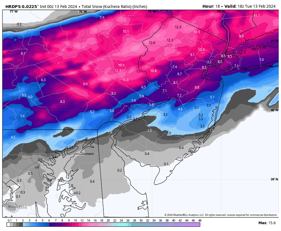
I admire you sticking to your call but the thing that bothers me in this run is there is one hell of a discrepancy of 6 inches vs 17 inches. Thats nearly an inch or so more of available precipitable water for snow making. LIke I said another 8 hour run or so should iron some of it out. But even if I took half of that extra precip out this run, it would still meet winter storm warning easily. 8-12+ in seems more in line if this trend continuesThe 8-12 being called for on Sunday was pretty good estimate. I have least 8 inches on the ground now. Trees bending on the weight of the snow. Real good snowman making snow. Did not get the thundersnow but I will take the pukage of snow right now.
-
1
-
-
8 minutes ago, LVblizzard said:
Hi-res RGEM went crazy for the LV and Poconos!
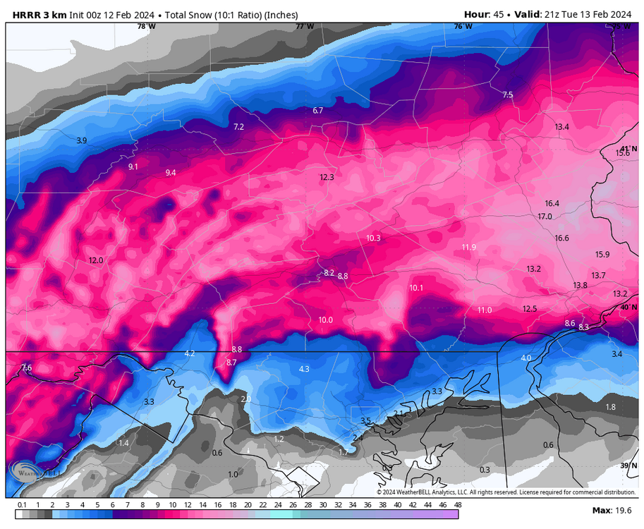
notice where the 12+ lollipops are in this map just posted near RT 100/Rt 29 near Bear Creek Ski resort elevation driven. I must say I feel real fortunate that macungie area seems to be in the center of it all. I hope this keeps up. I just want to see thundersnow.
-
As I spoke in other posts the last few days, South Mountain range may be the jackpot. Elevation differences and location of the banding will be the determining factor. All the models hint at lollipops near a foot along RT 100 in the LV down through RT 29 in Upper Montgomery & Bucks County. I have seen this happen a bunch of times in the last 40 years. The sooner it starts snowing the better. Evaporative cooling will be significant as my temps are already in the mid to upper 30's
-
18 minutes ago, LVblizzard said:
Here’s the HRRR. The RAP is similar.
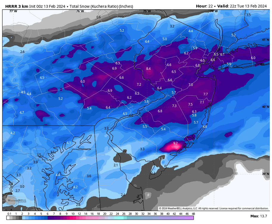
Pockets of 8+ inches still exist in SE Lehigh County on this map. Macungie near Bear Creek Mtn Resort is an example of this on the map. We must be realistic. There will be lollipops with banding. I am just glad we got a winter storm warning. Time to relax and let the sky start puking white stuff. I think many will be commenting on the snow rates in the morning. That is what makes this event special big snowflakes, intense, brief whiteout conditions and great sledding and snowman making.
-
1
-
1
-
-
after looking at the latest model runs, very high per hour snowfall rates will be achieved with this snowfall. The outstanding thing in this snow event is that whiteout conditions - like snow squalls will be achieved at times. Driving will be a complete nightmare everywhere. Four wheel/all wheel drive vehicles that are high profile will be the main vehicles driving around. The main arterial and local intersections and interstate on/off ramps will be an absolute clusterF&*k with stranded or incapacitated vehicles as the plows will not be able to keep up to keep the roads clear with the snowfall rates. PADOT MUST Issue their warnings this afternoon/ this evening to keep empty trucks trailers and oversize vehicles off the roads in the LV. I would recommend a Tier 3-4 warning based on the intensity of the snowfall and not just on the anticipated accumulations. IMHO, if you do not have to be out do not go out. Its the other drivers that I worry about as many younger drivers have not experienced 4-6 inch snow covered roads to drive on in without being plowed in over five years. The media must point this out. Imagine now that many drivers in their mid to upper twenties have never experienced these anticipated winter conditions since 2016. This storm will be a different animal hitting our area during peak morning rush hour and snow coming down pretty hard than many drivers have seen. Good luck https://www.penndot.pa.gov/TravelInPA/Winter/Pages/Vehicle-Restrictions.aspx
-
1
-
1
-
-
48 minutes ago, LVblizzard said:
I’m noticing that some of the hi-res/meso models now only have rain for a very short period of time towards I-78, with the majority of precip being snow. Some of them change the Lehigh Valley to snow as early as 2-3 am.
we might just hit that foot of snow mark good
-
1
-
-
I admire you sticking to your call but the thing that bothers me in this run is there is one hell of a discrepancy of 6 inches vs 17 inches. Thats nearly an inch or so more of available precipitable water for snow making. LIke I said another 8 hour run or so should iron some of it out. But even if I took half of that extra precip out this run, it would still meet winter storm warning easily. 8-12+ in seems more in line if this trend continues
Yep, Mt Holly went with my old fart thoughts. We actually got our warning in the LV before the snow event Time to celebrate- the warning drought is over LOL
I also feel much better after reading their forecast discussion about the explosive snow growth too as the temps fall to near or below 30 degrees adds to the accumulations. Folks, with this much dynamics in play now, can we get some thundersnow too? That would be the icing on the cake. Will Jim Cantore show up somewhere in the LV? Analogy storm Feb 1983 snow storm fits well at this time as I remember the LV received 3-5 in an hour snow rates with 24" of snow. My parents were stuck in that storm and was their first taste of a blizzard in the LV. I was in my 20's at the time and did not mind. Seems plausible at this juncture that this storm will somewhat similar with its formation with the LP sitting near the sweet spot at the Chesapeake after the transfer and getting stronger. Snow accumulation amounts should be much less for this storm but the snow rates will be up there for sure for a few hours. Visibility will be down for sure with the monster flakes. Been long time since we have seen this type of snow storm event unfold in the LV.
1996 and 2016 LV blizzards were different as the they were both much longer in duration, the temps were much colder and the size of the flakes were smaller. This storm event may unfold like 1983
-
1
-
-
8 hours ago, Albedoman said:
I admire you sticking to your call but the thing that bothers me in this run is there is one hell of a discrepancy of 6 inches vs 17 inches. Thats nearly an inch or so more of available precipitable water for snow making. LIke I said another 8 hour run or so should iron some of it out. But even if I took half of that extra precip out this run, it would still meet winter storm warning easily. 8-12+ in seems more in line if this trend continues
Yep, Mt Holly went with my old fart thoughts. We actually got our warning in the LV before the snow event Time to celebrate- the warning drought is over LOL
I also feel much better after reading their forecast discussion about the explosive snow growth too as the temps fall to near or below 30 degrees adds to the accumulations. Folks, with this much dynamics in play now, can we get some thundersnow too? That would be the icing on the cake. Will Jim Cantore show up somewhere in the LV? Analogy storm Feb 1983 snow storm fits well at this time as I remember the LV received 3-5 in an hour snow rates with 24" of snow. My parents were stuck in that storm and was their first taste of a blizzard in the LV. I was in my 20's at the time and did not mind. Seems plausible at this juncture that this storm will somewhat similar with its formation with the LP sitting near the sweet spot at the Chesapeake after the transfer and getting stronger. Snow accumulation amounts should be much less for this storm but the snow rates will be up there for sure for a few hours. Visibility will be down for sure with the monster flakes. Been long time since we have seen this type of snow storm event unfold in the LV.
1996 and 2016 LV blizzards were different as the they were both much longer in duration, the temps were much colder and the size of the flakes were smaller. This storm event may unfold like 1983
-
1
-
-
The NAM showed total positive snow depth accumulations meeting or exceeding warning criteria for the LV first the time in several years in tonight's run This is a promising trend that the winter storm watch may be upgraded to an actual warning before the snow event even actually occurs and not during the event . That has not happened in 2-3 years. To me, that is what I have been waiting for this entire year. Once that warning is issued- it can snow a foot or more- I really do not care about being too specific on totals. I think many of us are waiting for the magical warning to be issued too. We have all waited way too long.

-
1
-
1
-
-
2 minutes ago, LVblizzard said:
The “long range” HRRR past 24 hours typically isn’t very good. Until I see a clear trend from every other model towards this solution (which I don’t think will happen) I’m sticking with 3-6” for our area.
I admire you sticking to your call but the thing that bothers me in this run is there is one hell of a discrepancy of 6 inches vs 17 inches. Thats nearly an inch or so more of available precipitable water for snow making. LIke I said another 8 hour run or so should iron some of it out. But even if I took half of that extra precip out this run, it would still meet winter storm warning easily. 8-12+ in seems more in line if this trend continues
-
13 minutes ago, Kevin Reilly said:
NAM and dynamical models tonight will be telling at 0z wow!
If these models agree with the HRRR run in the last hour , there will be major changes in snowfall totals
-
1
-
-
15 minutes ago, LVblizzard said:
Good lord the HRRR completely wrecks everyone!

LV Blizzard, based on this MAJOR change, Mt Holly should issue a winter storm warning for the LV if this model shows this again at the 6z . Its hard to argue the map below as this is a pretty accurate sr model
-
2
-
-
12 minutes ago, TriPol said:
Anyone remember the vday storm of 2007? We got a couple of inches… of sleet! It was by far the worst sleet storm I’ve ever seen. Any chance of a redux?
NO way in hell. completely different setup with arctic air already in place from clippers in 2007. Here is your reminder- from the old weatherman https://en.wikipedia.org/wiki/February_2007_North_American_blizzard
-
4 minutes ago, LibertyBell said:
South Mountain Range.... is this anywhere near Lehighton?
Lehighton is located on the Blue Mts range- Appalachian Trail location. South Mountain is a lower elevation ridge of mountains/hills that separates Lehigh Valley on the southeast side of the Lehigh Valley running parallel to the Delaware River up to about Easton. For example - I-78 traverses over South Mountain at the Route 309 interchange- the huge hill before you come into the Allentown area. Anything southeast of Allentown is more in the Fall line area. Many times it snows in Allentown but not in Quakertown and points southeast because of the South Mountains, In fact Bear Creek ski resort in Macungie is in the top ten of ski resorts in the US is also at the top of the South Mountain Range and I live about 5 miles from it https://www.thetravel.com/best-mountain-resorts-in-the-us-for-winter/#bear-creek-mountain-resort-pennsylvania-a-mountain-wonderland
-
2
-


The Official Unofficial Overnight February 16/17th Snow/OBS Thread
in Philadelphia Region
Posted
At the rate this LP is getting juiced in the latest model runs, 4-6 in from a line from Reading over to Central Montgomery/Bucks County seems likely. Betting WSW will be issued from Norristown south where the 5 In criteria maybe met. If I was Mt Holly , I would issue a winter storm watch for the other areas to the immediate north up to the LV and wait until the 00Z runs come in for the NAM/HRRR to either upgrade to a WSW or downgrade to an advisory. Everyone else a WWA. Confidence is real low for reaching WSW criteria north of Norristown. The best part is that this will be a plowable event for most everyone.