

Albedoman
-
Posts
1,386 -
Joined
-
Last visited
Content Type
Profiles
Blogs
Forums
American Weather
Media Demo
Store
Gallery
Posts posted by Albedoman
-
-
Less than .50 in western lehigh county- no drought buster thats for sure. Btween outflow boundaries-- looks like crap the rest of the day. The outflow boundaries from this individual cells to the south and north are just crushing redevelopmnet or training t- storms in the LV. I think we are done for the day now
-
 1
1
-
-
In addition to nearly three-quarters of an inch of much-needed rainfall, the thunderstorm also scrubbed weeks of smoke, dust, and other airborne particles from the atmosphere. The rain washed these fine particles onto the landscape while lightning naturally converted atmospheric nitrogen into plant-available forms that were carried into the soil. Although the amount of natural nitrogen is modest compared to commercial fertilizer, every pound helps during a critical stage of crop development. Just as important, the cleaner air and washed foliage allow crops to capture more sunlight, improving photosynthesis and helping fields recover from weeks of drought stress.
-
1
-
-
After weeks of relentless heat and drought, western Lehigh County finally received its first measurable rainfall in weeks this morning. The thunderstorm produced nearly 0.75 inches of rain, falling in several intense downpours that soaked the ground just in time.
For local agriculture, this rainfall was nothing short of a multi-million-dollar blessing. Corn fields had reached the critical tasseling and silking stage, when adequate moisture is essential to determine kernel development and final yields. Soybean fields were showing increasing signs of drought stress, with curled leaves and slowed growth becoming more evident each day. Without meaningful rainfall, crop losses would have escalated rapidly.
This storm likely saved tens of millions of dollars in potential agricultural losses across western Lehigh County. While it certainly does not end the drought, it arrived at one of the most critical periods of the growing season. Soil moisture has been replenished enough to relieve immediate crop stress, allowing corn and soybeans to resume active growth.
Beyond the water itself, thunderstorms provide another often-overlooked agricultural benefit. Lightning converts atmospheric nitrogen into plant-available nitrate compounds that are carried to the ground by rainfall. Although not a substitute for fertilizer, these natural nitrogen additions can provide a modest nutrient boost, helping crops recover more quickly after prolonged dry weather. Just as importantly, the rainfall washed dust, pollen, and other airborne particles from the atmosphere, improving air quality while refreshing plant foliage.
There is still a long way to go. Subsoil moisture remains well below normal, and additional widespread rainfall will be needed over the coming weeks to sustain crop development through pollination and pod filling. Nevertheless, today's storm represents a major turning point. For farmers who have watched their fields deteriorate under weeks of dry weather, this rainfall was more than welcome—it was timely, valuable, and may ultimately prove to be one of the most important weather events of the summer.
-
1
-
-
-
19 hours ago, Voyager said:
The Jordan Creek along route 100 looks about ready to dry up completely. I've never seen it this low before.
Thats the Township that I manage where you see the Jordan Creek. By the way, I got an email from PADOT yesterday, that same bridge you went over on RT 100 is going to be replaced in 2029 with detours. Not going to be easy
-
Swing and a miss again . Here comes the drought emergency
-
this is what I mean by the winds

-
3 hours ago, JTA66 said:
Earlier in the week my forecast high for today was 100F. It's been scaled back to 96F. Wonder if the haze from the wild fires is a factor?
84F/DP 72F
Unfortunately, the Lehigh Valley will likely be even hotter today. The stiff, breezy westerly winds bringing wildfire smoke into the region are also acting much like a Santa Ana wind as they descend the Blue Mountains, warming and drying the air. Humidity is very low, and it's already 95°F at noon.
I wouldn't be surprised if Allentown and Reading reach 100°F or higher this afternoon, while the Philadelphia area may stay a few degrees cooler because it won't benefit from the same downslope warming effect.
-
Total whiff for the lv tonight. Whatever padep or usgs comes up with for drought maps this week, they mean zilch. Let the real drought reports begin.
-
Last chance for a t storm following the ne turnpike. It all or nothing for the LV in the next few hours.
-
LV swing and a miss strike 3 we are out of t storm chances for today. The 7 10 split lives on. Just incredible outflow boundaries preventing us from getting decent rain. 50 miles on either side of the lv gets 2+ in of rain.
This is no longer funny. Another week of no rain and temps near 100 , the little lehigh will go dry in spots. I really see a drought emergency issued by Lehigh County Authority by next weekend. The lawns will be burned if people mow them this week and corn will be spiking.
-
1
-
-
LV swing and a miss strike 3 we are out of t storm chances for today. The 7 10 split lives on. Just incredible outflow boundaries preventing us from getting decent rain. 50 miles on either side of the lv gets 2+ in of rain.
-
1
-
 1
1
-
-
3 hours ago, LVLion77 said:
0.71” here in sw Lehigh County. Looks like the Lehigh Valley this far is on the lower end regionally while Philly, northern Poconos and Reading all got significantly more. There are a few spots in the poconos that may have gotten several inches per radar estimates.
Same here. The lv got screwed again. The models cannot handle the dryness. The corn is smiling again. All we have gotten is the bad wind damage
Ling
-
1
-
-
9 minutes ago, Joshb32689 said:
Couple large limbs and branches down on our property from yesterday, but thankfully no damage. My wildflower bed is hurting after the wind - the pitfalls of chaos gardening.
CAMs printing some hefty rain totals over Long Island in the short range. 12”+ in some cases. Some big rain potential down this way too. Currently seems maxed out at 6-8” in isolated spots.
I’ll just take some steady rain today please and thank you.
Thanks Ron. Have a laughlvulin on me
-
2 hours ago, Voyager said:
Has the Jordan Creek ever come close to flooding route 100 by Hoffman's garage or the KOA turnoff?
Absolutely. In fact that is where the dead ash tree in the streambed is a series problem. . The culverts were blocked a year ago and padot got in trouble by padep for cleaning out the Jordan creek too well.
-
 1
1
-
-
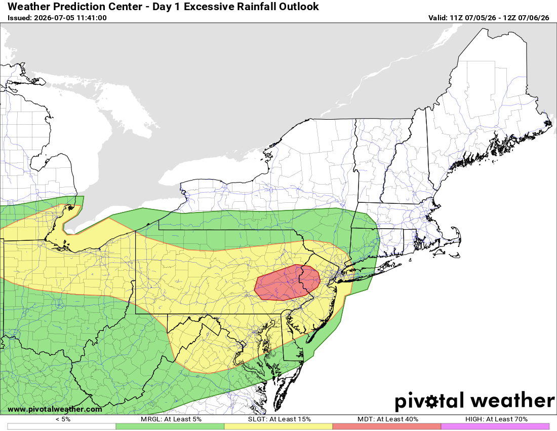
9 minutes ago, Newman said:

..Mid-Atlantic...
Farther downstream, scattered to widespread heavy rainfall will be focusing along the wavy, east-west orientated frontal boundary draped over the northern Mid-Atlantic states and offshore south of Long Island. Back building/training of slow moving storms capable of hourly rates rates greater than 2 inches/hour will track across eastern Pennsylvania and New Jersey this evening. Guidance is signaling areal averages of 3 to 6 inches with local maximums of 8+ possible along this corridor.
The latest guidance maintains focus of the highest probabilities for the intense rain rates and higher QPF over central to eastern PA, portions of central to northern NJ, and far northern Maryland. The combination of some terrain areas and the highly urbanized corridor makes this area much more vulnerable to flash flooding.
While there remains some spatial uncertainty to exactly where the greatest rainfall will occur, the setup favors locally significant flash flooding with the Moderate Risk over eastern Pennsylvania and north/central New Jersey embedded in the Slight Risk that now spans from northeast Indiana and southeast Michigan (including
Detroit) through the Mid- Atlantic Coast from NYC to central Virginia.This is what I was seeing last night as a potential for training t storms overe my area. I saw this similar setup in the 90,s. That's why I am concerned about down trees acting as debris dams in the flooded streambeds 5 + inches of rain will cause this to be a serious problem on major road bridges. Yes the rain is needed but not in 4 to 6 hours. Really. You should all drive around and look all the fallen dead trees in the streambeds now. It's horrific
-
1
-
-
While I only received about 0.75 inches of rain over the last two days, the winds have been quite impressive. With many areas still without power—from Lower Macungie all the way to Quakertown—I have no doubt that numerous fuses, transformers, and sections of the electrical distribution system have been damaged.
I have been fortunate. Most of the electrical service in my neighborhood is underground, and the surrounding trees were extensively trimmed after Hurricane Sandy. That has undoubtedly made a difference.
It raises an important question: Why aren't we making a greater commitment to underground utility infrastructure? Municipalities should be encouraged to require underground electric service wherever practical, while state and federal grant programs should help utilities such as PPL modernize aging infrastructure. Although the upfront costs are significant, the long-term benefits in reliability, public safety, and reduced storm damage are substantial.
Many people also don't realize that restoring power isn't as simple as replacing a wire. Utility crews must first remove fallen trees, inspect miles of damaged circuits, replace transformers and fuses, repair broken poles and conductors, and verify that each section of the electrical system is safe before power can be restored. That process takes time, especially after a widespread wind event.
What has made this year particularly challenging is the unprecedented number of dead ash trees killed by the emerald ash borer. As a township manager, I have been urging elected officials to dedicate funding for the safe removal of these hazardous trees, yet the response has largely been silence. These dead ash trees are creating the conditions for our next major disaster—not only through repeated damage to our electrical infrastructure, but also by increasing the likelihood of debris jams in our streams and rivers that can dramatically worsen flooding during future heavy rain events. A single blocked bridge opening or culvert can cause water to back up quickly, flooding roads, homes, and farmland even when rainfall amounts alone might not have produced significant flooding.
The reality is that mitigation is almost always less expensive than disaster recovery. Every dollar invested in hazardous tree removal, stream maintenance, and more resilient utility infrastructure can save many times that amount in emergency response, prolonged power outages, property damage, and disaster recovery costs. Waiting until after the next major storm is simply the most expensive way to solve the problem.
I am also surprised that there has been relatively little discussion tonight about the potential for our first widespread 3–5 inch rainfall event over the next three days. Forecasts can certainly change, but this is a weather system that deserves close attention. Perhaps many of us have become conditioned by the persistent drought of the past six months and tend to dismiss heavy rainfall forecasts. However, if this event unfolds as currently projected, localized flash flooding, stream flooding, and river flooding could become a very real concern—especially where fallen trees and debris restrict stream channels.
Anyway, enjoy the cooler weather, and let's hope the forecast trends downward. But this is definitely one of those situations worth monitoring closely over the next several days.
-
1
-
1
-
-
-
Yep my area was the hardest hit from the these storms this evening- from 102 temps down to the mid 70's comes with derecho type straightline winds like I said earlier this week could happen. Only .31 in of rain but the winds were bad. Spent an hour picking up dead limbs/branches in the yard and street. this happened less than 1 mile from the house----
Severe thunderstorms moved through the Lehigh Valley on Friday evening, temporarily dropping temperatures amid the extreme heat, but also causing significant tree damage that cut power to thousands of area residents just as Fourth of July celebrations get started.
Some of the worst storm damage was reported in the Alburtis and Macungie areas, where numerous downed trees dotted the landscape. Alburtis declared a “state of emergency” due to the damage.
“Please avoid unnecessary travel, stay clear of downed trees and power lines, and follow all guidance from emergency personnel,” according to a post on the borough’s Facebook page around 9:30 p.m. “Updates will be provided as crews continue assessment and restoration efforts.”
One tree fell onto a house on West Fifth Street in the borough, tearing away part of the roof. A freight train was also stopped in the borough due to a large tree that fell on the tracks, blocking both railroad crossings on North Main Street and West Penn Avenue.
As of 8 p.m., PPL’s outage map reported nearly 12,000 customers without power in Lehigh and Northampton counties. Areas reporting more than 1,000 outages included Washington Township, Upper Milford Township, South Whitehall Township and Lower Macungie Township in Lehigh County, as well as Northampton borough and
-
2
-
-
Just got hammered 60 mph wins. 35 in of rain. Nice rainbow. From 102 t0 92 in a few minutes
-
1
-
1
-
-
Just now, Albedoman said:

yes it is over 103 at my house with the winds now blowing from over the mountains heatint us up even more. Typical day in Southern Cal for me. I see a drought emergecy being delared for Lehigh county by the end of next week if we do get any t- storms after Saturday night. The corn is spiking and soybeans are now shriveling
-
-
-
Over 100 at the house now. missed any rainfall to the ne of me


E PA/NJ/DE Summer 2026 Obs/Discussion
in Philadelphia Region
Posted
The Tornado Watch should be cancelled. Continued widespread cloud cover and persistent outflow boundaries have stabilized the atmosphere, effectively eliminating any meaningful opportunity for convective redevelopment and significantly reducing the tornado threat. simply the latest bust as Red sky has stated. The only thing that will killl this nuisnace pattern is a tropical event or a cold front stalled with redevleoping shortwaves on the front. Cannot remeber the last time I saw this scenario.