

Albedoman
-
Posts
1,391 -
Joined
-
Last visited
Content Type
Profiles
Blogs
Forums
American Weather
Media Demo
Store
Gallery
Posts posted by Albedoman
-
-
3 hours ago, penndotguy said:
So we are looking at a potential true Miller A type of storm for Tuesday with the L coming out of the gulf states and a cold air source to the North. When was the last time we saw type of setup? It’s been a while.
- Location:Lower Macungie Twsp
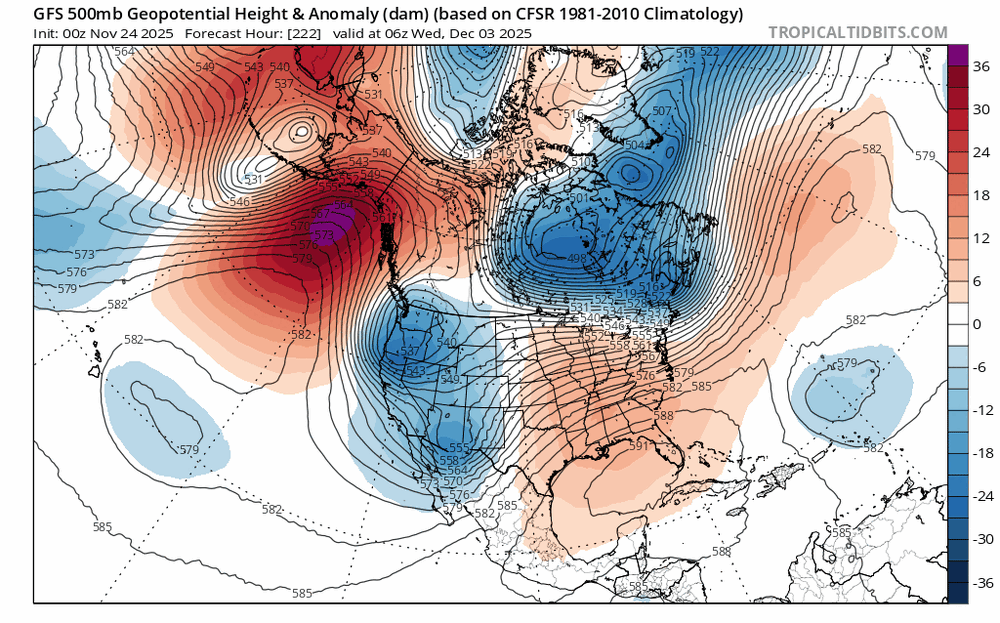
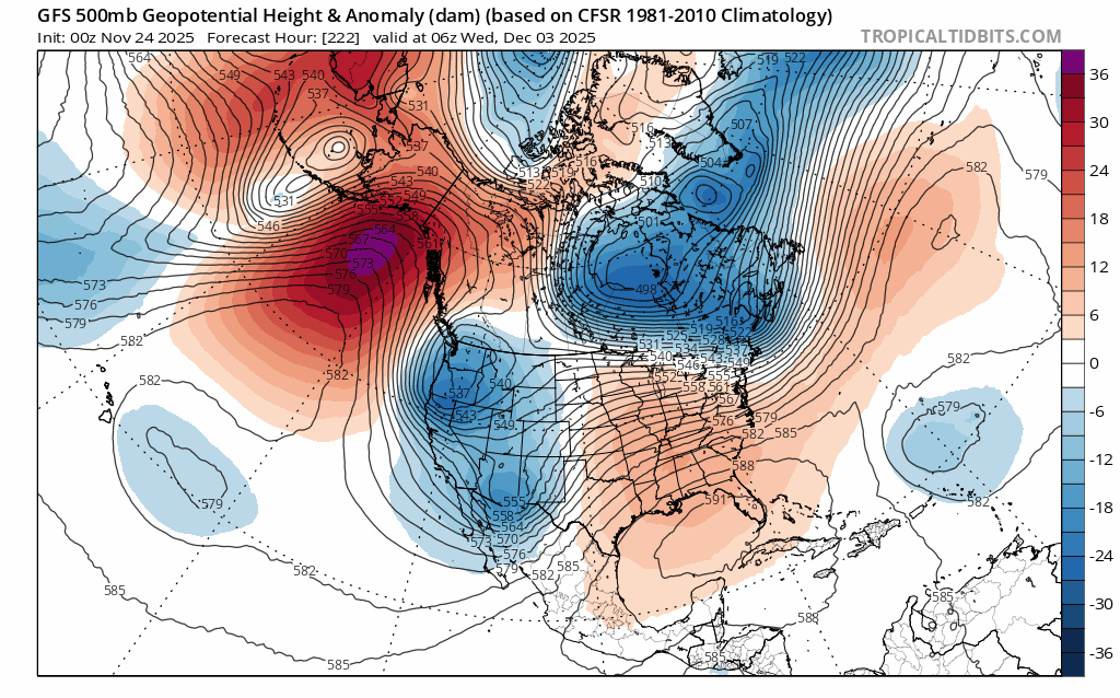
The models have shown only one positive thing in the last two weeks for a major pattern change and a possible major snow event for us but when it will ever occur will just be plain luck. If you old timers recognize the current major pattern shift on the last weeks runs which we have not seen in nearly 6-10 years is identified as the four corner lows which are developing and pushing into the Gulf of America. Then these lows are quickly re-energized with a ton of moisture and are setting up for a good Miller A type of storm event- rain or snow along the east coast. The lows south of New Orleans into Tampa are impressive on the model runs. This is the best look in model runs in a long time as it appears the GOA is opening back up for business, however these low pressure systems are also quickly becoming southern sliders too. The cold dry air that does come through with a cold front is NOT retreating back up into Canada so quickly before the moisture reaches us. Would not be surprised if the Carolina's up to Washington DC sees more accumulating snow then us this year. This pattern is slowly setting up for a lot nuisance mix storm events snow/sleet to rain for our area if this keeps up. A pure snow event will be hard to come by in the next few weeks
-
1 hour ago, simbasad2 said:
New to Americanwx so I'm still trying to figure things out here. How far usually 'til a storm thread is made?
snow weenie amounts of 4-6+inches of snow and or .25 inch of ice for 2-3 runs with DR No and the GFS also agreeing and within 3 days of the event will usually get a good one started in this forum. We are a long way from that now. LOL
Last year, it only took winter weather advisory level events to kick one up - we are so snow starved and have been spanked and run down the beaten path with a bunch of events that tuned out to be absolutely jack. This forum is pretty much gun shy for starting storm threads by having been burned so much the last 5 years with pity storms. In the MA forum, you will roasted over the coals for jinxing their forum by starting one. LMAO
-
 1
1
-
 1
1
-
-
5 hours ago, simbasad2 said:
Well... I'd be lying if I said I wasn't surprised. Not sure if I said this here or just thought it to myself, but I was convinced that the early December torch signal was gonna break the streak of every E US Ridge trending into a trough. And that we were going to be flooded with 60s to start the meteorological season. Todays 18z suite so far looks to be an extension of the trends already present on the 12z runs. We might even have our first accumulating snow event of the season. Per the 18z GFS, a relatively weak shortwave will round the base of the longwave/TPV lobe and a fast moving system could bring some light snowfall for someone in the Mid-Atlantic or Northeast early next week. Hopefully this isn't a repeat of 2024-25 where everything does a mega south trend to Antarctica
I agree. The low pressure shortwave ejecting from the Tenn Valley(GOA) has got to have some decent moisture for us to get some decent overrunning. For many years now, the these ejecting lows have been bone dry. Lets hope the mosture gets involved this time before the dry air wins out. Literal crap shoot until 48 hours before the event.
-
I usually do not post in this forum but I feel for you guys too. AS I said a few days ago in the Philly forum:
Where the hell these long range so called weather gurus snow weenies seeing snow for our area on facebook and other media sources and who are just trying to make a few advertising bucks playing up the polar vortex bs but the current models are sure are NOT portraying anything like this right now for our area.. Every single snow chance has now dwindle to rain/mix event and also an insignificant rain event at best for our area as the cold dry air is winning the battle.
The models have shown only one positive thing in the last two weeks for a major pattern change and a possible major snow event for us but when it will ever occur will just be plain luck. If you old timers recognize the current major pattern shift on the last weeks runs which we have not seen in nearly 6-10 years is identified as the four corner lows which are developing and pushing into the Gulf of America. Then these lows are quickly re-energized with a ton of moisture and are setting up for a good Miller A type of storm event- rain or snow along the east coast. The lows south of New Orleans into Tampa are impressive on the model runs. This is the best look in model runs in a long time as it appears the GOA is opening back up for business, however these low pressure systems are also quickly becoming southern sliders too. The cold dry air that does come through with a cold front is NOT retreating back up into Canada so quickly before the moisture reaches us. Would not be surprised if the Carolina's up to Washington DC sees more accumulating snow then us this year. This pattern is slowly setting up for a lot nuisance mix storm events snow/sleet to rain for our area if this keeps up. A pure snow event will be hard to come by in the next few weeks
I basically want a 2-4 in long duration three day rain event asap to get the trees feet wet before the ground freezes and to get runoff back into the soon to be dry streams. Trout fishing and landscaping this spring will be severely hampered too if you do not get some significant rains in the next 2-3 weeks. When LCA declares a drought watch folks,its pretty serious. I have USGS gauging stations in my backyard for the Little Lehigh and if this stream dries up, the businesses will be greatly affected too throughout PA
-
2
-
 2
2
-
 1
1
-
-
Where the hell these long range so called weather gurus snow weenies seeing snow for our area on facebook and other media sources and who are just trying to make a few advertising bucks playing up the polar vortex bs but the current models are sure are NOT portraying anything like this right now for our area.. Every single snow chance has now dwindle to rain/mix event and also an insignificant rain event at best for our area as the cold dry air is winning the battle.
The models have shown only one positive thing in the last two weeks for a major pattern change and a possible major snow event for us but when it will ever occur will just be plain luck. If you old timers recognize the current major pattern shift on the last weeks runs which we have not seen in nearly 6-10 years is identified as the four corner lows which are developing and pushing into the Gulf of America. Then these lows are quickly re-energized with a ton of moisture and are setting up for a good Miller A type of storm event- rain or snow along the east coast. The lows south of New Orleans into Tampa are impressive on the model runs. This is the best look in model runs in a long time as it appears the GOA is opening back up for business, however these low pressure systems are also quickly becoming southern sliders too. The cold dry air that does come through with a cold front is NOT retreating back up into Canada so quickly before the moisture reaches us. Would not be surprised if the Carolina's up to Washington DC sees more accumulating snow then us this year. This pattern is slowly setting up for a lot nuisance mix storm events snow/sleet to rain for our area if this keeps up. A pure snow event will be hard to come by in the next few weeks
I basically want a 2-4 in long duration three day rain event asap to get the trees feet wet before the ground freezes and to get runoff back into the soon to be dry streams. Trout fishing and landscaping this spring will be severely hampered too if you do not get some significant rains in the next 2-3 weeks. When LCA declares a drought watch folks,its pretty serious. I have USGS gauging stations in my backyard for the Little Lehigh and if this stream dries up, the businesses will be greatly affected too throughout PA
-
well drought guy, here. These pity rain events is killing us now. Just issued a drought watch for my water supply. The bad thing is that it did not come from PADEP or the USGS, it came from my water authority LCA. This is getting serious as this affects the water bottling companies as well as 200,000 residents in the LV. Where is 2-3 in rainfall from a noreaster? WeE can not even squeeze out a popcorn fart for a decent rainfall event. Every time I look at the models, the snow potential keeps getting push back to the middle of December too. Welcome to the arid tundra region again.
-
the big pattern change is afoot- 4 corners lows constantly ejecting toward us for the next 3-4 weeks. One of them should be a minimal car topper event but still the GOM is not opened for business yet. We really need one of the 4 corner lows to go into the GOM and then run up the coast and stall as a Miller A. The PAC winds are just to strong right now and too progressive. Three more days of 40+ winds coming this week. I am so tired of dealing with dead ash trees falling with our public works dept.
-
finally,some rain to keep the leaf piles from blowing away tomorrow.
-
35 minutes ago, Birds~69 said:
More reds developing. Maybe I'll get on the horn and wake drought guy...still warm out, 60 F
too late missed me
-
2 hours ago, Birds~69 said:
Rain heading through Reading and on my doorstep. Drought guy is probably so damn excited he can't even sleep...
56F
sorry, I could pee more than this rain. I am more exited about seeing the possibility of white rain in the next few days. I will sleep just fine tonight. At least the wind has stopped. Tired of seeing down ash trees.
-
My first shot at this potential event-- the coastal timing will bounce back and forth on the 10th to 11th. I only expect a white rain event at the best. Just not cold enough to see accumulating snow this time of the year in the valleys. The cold air has not been really locked in yet. Strictly an elevation event if it does occur--about 1500ft for accumulating snow. South Mtn range is my best guess at this time to see the best chance of accumulating snow in our area. The big takeaway IMHO- it will finally feel like winter again, with highs in the mid to upper 30's and the heat will finally have come on. The GEM sees something on the noon run but the snow hits at the very tail end of the storm. The GFS will be bouncing all over the place the next 5-7 days typical with the govt shutdown for additional air soundings in the Pac west
-
On 10/31/2025 at 4:23 PM, Albedoman said:
noon runs look like an overrunning situation possibly forming after a cold frontal passage near 11/13 with cold enuf temps to have frozen precip. Something to watch. The cold frontal passage on the 10th will bring hard freezes with temps in low 20's and high in the upper 30's.
now it is showing up on tonights run. First flakes of the year?

-
noon runs look like an overunning situation possibly forming after a cold frontal passage near 11/13 with cold enuf temps to have frozen precip. Something to watch. The cold frontal passage on the 10th will bring hard freezes with temps in low 20's and high in the upper 30's.
-
8 hours ago, LVblizzard said:
Sandy redux on the 12z Canadian late next week. Could be some interesting days of tracking ahead.
All I know is this scenario model run better not happen. After looking at the CMC noon run, this would make Sandy look like a baby. With all of the dead ash trees in Eastern PA now and especially in the LV and urbanized and major riverine flooding, this would be a one hell of a disaster for our area. I would see unbelievable debris dams in the waterways from these fallen limbs and trees that would wipe out major bridges in our area. The power outages would be unmanageable and you will not find a generator in stock for 250 miles from our region. The fact this scenario is already showing up for one week away warrants further discussion by all pro's. Even a slight hit would be a huge concern. There will nothing left at the NJ beaches for next year beaachgoers and NYC will get one hell of test of its new subway drainage pumping system. Definitely will keep an eye on these model runs as the media and so-called internet weather gurus on facebook/youtube will play this up real good in the next few days if the the model runs continue to show this tonight and tomorrow. Can you say Panic?
-
Just had a thundershower- light ---here in lower macungie
-
My forecast did suggest a slow start. Enjoy the fall weather while you can. Come january you will be wishing for temps above 45 . I expect more mix events than anything else in late nov into mid dec as the pattern sets up for january
-
9 hours ago, JTA66 said:
I don’t recall, but I’ll say the girls.
Let’s face it, if I had the ball and a bunch of girls were chasing me with the objective of tackling me and rolling around in the mud…yeah, I’m not going to try my best to avoid that outcome.
9 hours ago, PhiEaglesfan712 said:Mud football games are fun. My sister played in one during her senior year of high school as a running back. The next door neighbor was a junior in high school, and the running back of the other team. No one was able to stop either of them that day. My sister's team ended up winning.
Who won your game?
(Oh, and I bet you if Drought Guy was around when Gloria was happening, he'd be talking about how a drought was around the corner...)
sorry, I was not living here in PA at the time so I never experienced what was going on. I was down in Memphis Tn at the time. I had other hurricanes to deal with down there at the time Elena but more importantly, Memphis had over a foot of snow in one storm in the winter of 85 . That would be like a 3 ft snow here.
-
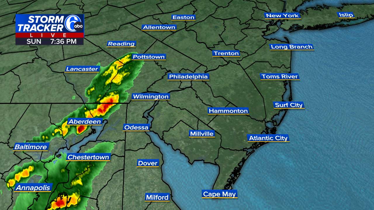
Million dollar t storms right now
-
5 hours ago, RedSky said:This AfternoonForecast Sunny, with a high near 78. South wind around 5 mph.Dense cloud cover all day not a ray. But not a complaint it's been the best weather ever for weeks and weeks
Drenching downpours are coming in the next two days says the drought guy. Million dollar rains for landscapers and for fall colors
-
9 hours ago, RedSky said:
Leaves are yellow and falling off the trees in the Wal Mart parking lot in mass. Too early looks strange.
Not included in the abnormally dry in the last drought maps i have seen which is bizarre it's a tinder box in the woods.
Drought guy were in trouble man
I am not too worried yet. Its dry like this on average years during this time frame. Concerns:
1. Being a neutral year, we are in for a real cold and snowy winter which will definitely help the groundwater tables. See lots of northeaster's and the potential freezing rain/sleet events early in December. Expecting some nice rains by mid October as the warm pattern breaks down. A good tropical storm up the east coast can really help get us out this stubborn pattern.
2. The leaves are scorched brown and falling off. No color until we have temps in the 40's again and highs only in the low 60's. Do not see that happening until the second week of October folks.
3. I agree. We need some decent rain by Wednesday, otherwise burn bans will likely go into effect in the next week or so. The canopies are dry and the scorched leaves falling are not helping.
4. Even the tent caterpillars died off in this early warm spell before autumn. This is been the latest I have run the AC in a real long time as overnight lows struggle to get to the 50's
-
1 hour ago, PhiEaglesfan712 said:
Drought guy wrong again. I've been drought free since March 5.
what are talking about? The drought ended back in July for the LV. Hell, I had 2.5 in of rain two days ago at my house. I would be more worried about us having a neutral winter this year and record cold come mid December . Enjoy your Halloween as the frigid air will come back near Thanksgiving this winter with more nor'easter chances.
-
2.15 inches at house in LMT= still raining
-
1
-
-
Getting hammered. Best t storms in a long time. Lighting hitting homes in our area. Thunder shaking the whole house. Picked up nearly an inch so far. This rain helped the corn and soybean yields
-
1
-
-
21 minutes ago, LVLion77 said:
Wow, did not expect nearly an inch of rain this evening. A welcome surprise and good fortune in the center of that band of heavy showers heading into very dry weather pattern.
1.25 at my house. Nice steady downpours tonight. There is no drought now with over 3.5 in the past week. The soybeans are the greenest I have seen them in a long time. Dewpoints in the 40's will be welcomed- more evening fires in the fire pit.


E PA/NJ/DE Winter 2025-26 Obs/Discussion
in Philadelphia Region
Posted
bullseye is south mountain/macungie- my house --should be under a winter storm watch based on this model. Mt Holly no time to be bashful. The drivers in the LV have not seen snow in a long time. At least get them concerned about this storm event. Its border line warning criteria I know but least get them prepared under a watch. Too many times in the last few years , an advisory level event has turned into double digit snowfall events