

rockchalk83
-
Posts
364 -
Joined
-
Last visited
Content Type
Profiles
Blogs
Forums
American Weather
Media Demo
Store
Gallery
Posts posted by rockchalk83
-
-
50 minutes ago, Wx 24/7 said:
I won't get excited about the weekend system. I won't get excited about the weekend system. I know the models are pulling a trick. I won't get excited. I won't.
Right there with you, especially after what the 18z NAM and 12z Canadian is showing.
-
1 hour ago, Weatherdemon said:
18z NAM with a few hours of snow left according to sim reflectivity
I’ll take ALL of that. But it’s the NAM at >12 hours so...
-
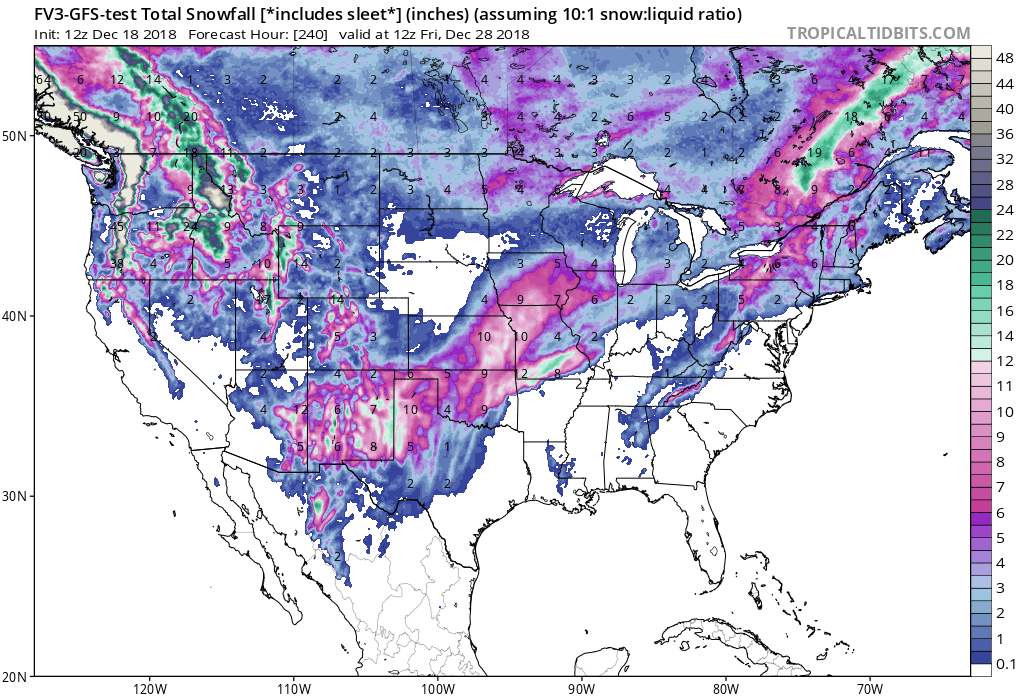
This troll job, courtesy of the 12z GFS-FV3

-
8 minutes ago, JoMo said:
yeah that system is going to be a pain. A narrow area of very heavy snow would be possible assuming everything comes together just right. Unfortunate that the cold air will largely be bottled up to the north and it will depend on system dynamics to produce that small area.
Completely agree. It will be one of those systems where it will be 36 or 37 and snowing but will take 1-2"/hour rates to accumulate on roads.
-
Here's the 06z GFS-FV3 for comparison. It lines up well with it's older counterpart, plus the 00z EURO & 00z Canadian:
-
 1
1
-
-
1 minute ago, JoMo said:
It was ugly. No snow for you or me. Maybe 2" or so in NW AR and Tulsa. Stripe of snow farther south but amounts aren't that great. Mixed precip... Ugly ugly ugly
Gross.
-
Gonna need details...lol
-
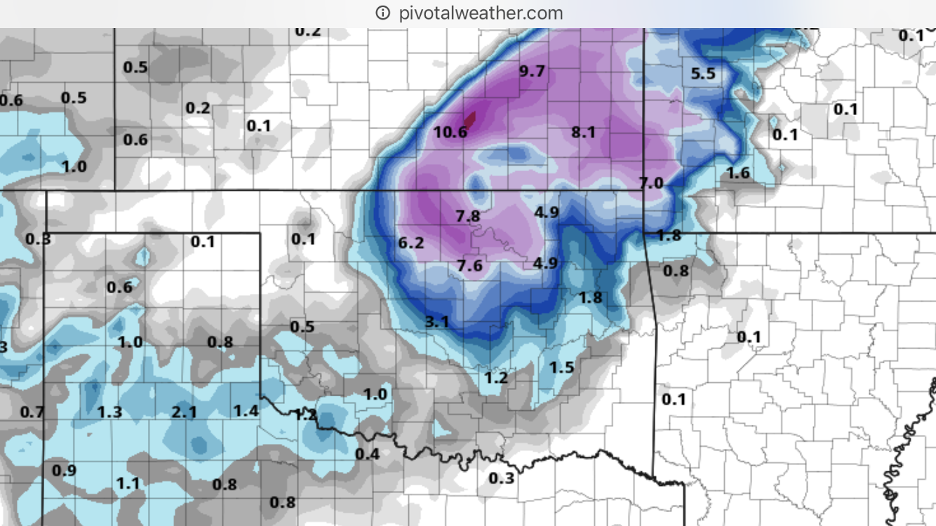
As it relates to the 18z NAM...it's closing off the 500 mb low much more aggressively than the others so far....with a 558dm low along the Red River. That process is the reason for the higher totals. Something to watch for sure, as the other models in the 12z suite have hinted at a closeoff, which would portend to a farther north track.
-
2
-
-
25 minutes ago, StormChazer said:
And for the record, the system is still ongoing......
.thumb.png.a2230ee2b7a2fe81cb0663eb515d40de.png)
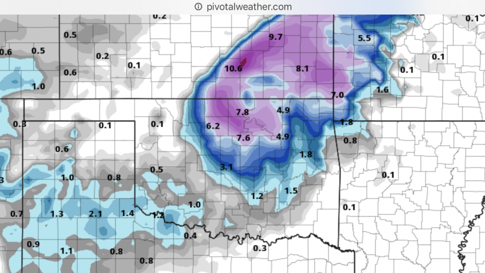
I cannot help but wonder how much of the hot colors...especially along the I-44 corridor and especially in AR...falls as sleet? Could be a substantial amount.
-
13 minutes ago, StormChazer said:
The NAM has lost it's mind.....
I’ll take it! 8” up here in SC KS
-
5 minutes ago, Weatherdemon said:
12z Euro still looks good for 4-6 in Tulsa.
Not a lot of change from the previous run.
Keeps things liquid until late Sat morning S of I44 in NE OK.
The 12z Euro is only out to 18 hours on Weathermodels.com. Are you getting it quicker somewhere else?
-
41 minutes ago, lovableweatherguy said:
Anybody think STL will get in on this storm this weekend? In our local forum will are holding on to some northern shifts with tonight's and tomorrow's runs.
Sent from my SAMSUNG-SM-N920A using Tapatalk
The NAM says no. Not even a shift north to bring S KS & S MO into play. >12" of snow for the I-44 corridor, though.
-
1
-
-
3 minutes ago, WhiteoutWX said:
NAM hangs the energy back and is slower like the Euro. But it’s also more consolidated and amped with the upper energy. Closes off at 500mb and looks to have quite the backside snows. Really this is a much different storm depiction altogether than what was being shown yesterday and previously. Modes were then showing mostly a warm air advection/overrunning scenario and open wave. This is a more consolidated storm. Long range NAM so beware but the Euro was also slower so this could be the start of a trend.
With a more amped system as the NAM & Euro would depict, is there a chance the system moves back north? The 18z GEFS seemed to suggest some decent snow accumulations into southern Kansas and Missouri.
-
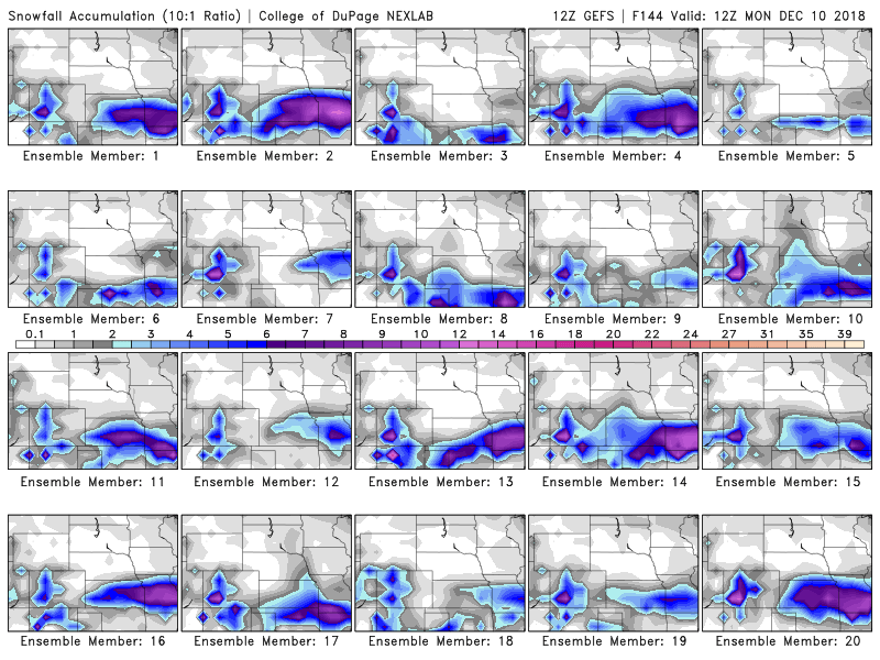
Here are the GFS ensemble forecast snow accumulations from the College of Dupage:
-
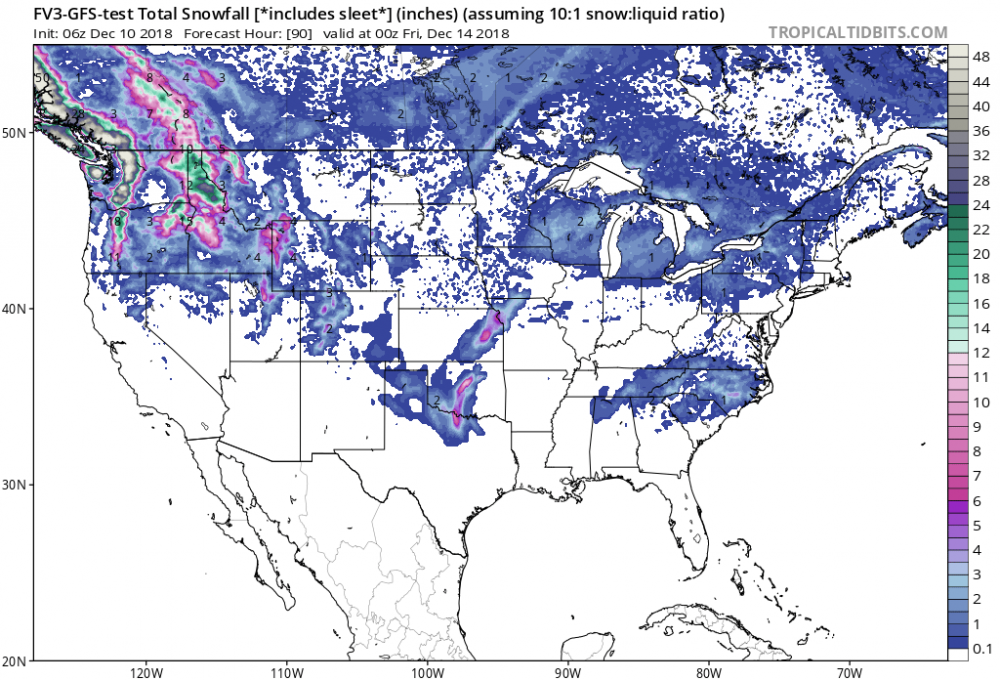
For those Oklahoma folk looking for snow, the GFS-FV3 is a non-starter. Has a sleet -> rain scenario for all but the panhandle for much of the event. Pretty decent snow accms in S MO, though.
-
1 minute ago, StormChazer said:
Wouldn't that give us a colder solution?
It does. There's very little ice on this run of the Euro. There is also a very sharp cutoff to the snow, with much of S KS & S MO missing out on the big accms.
-
Looking at the 12z Euro run in real-time and comparing it to the GFS/CMC models...the Euro is farther west with the high pressure, putting it in SW Iowa at 00z Saturday. The GFS/CMC have it over northeastern Iowa at that time. All the models have the high pressure at or near 1038 mb.
The end result of all that is that for most of our region, Friday may be dry. The lone exception would be across S & SE OK, where light rain could breakout during the day.
-
1
-
-
4 minutes ago, RocketWX said:
Hey all, been reading this thread for a few years. Finally decided to join and chime in from time to time. While I'm certainly not as knowledgeable as many on here, I received my degree in Geoscience from Mississippi State and also got my (often debated at times) Certificate in Broadcast Meteorology about 4 years ago now. I interned at KWCH and worked with Rodney Price and Ross Jansen on the weekends. Having said that I don't work in the field as I decided to go in a different direction but still have a passion for weather as others here. To be honest I've become rusty and I'm not as sharp as I was 3 or 4 years ago. I just miss talking weather with others and figured I would add on to the conversation from time to time when I have the chance. Oh, I live in Rose Hill, which is just Southeast of Wichita. This is where I got my display name.
Finally another SC Kansas reader! Welcome aboard.
-
1
-
-
20 minutes ago, JoMo said:
Def something up with the algorithm on the PGFS. Pretty though.

I don’t think it’s an algorithm problem, but more of the GFS-FV3 resolving a closed low at 500 mb, which leads to a more significant moisture envelope in the cold air versus an open wave like the other models seem to be doing. To me, that seems to be the key to the forecast right now and not the cold air.
It is interesting that the GFS, GFS-FV3, plus many of the GFS and EURO ensemble members were progging a closed low scenario during the overnight runs. Something to watch as we get into the mesoscale modeling beginning tomorrow.
-
18 minutes ago, JoMo said:
12z models were a bit farther south today (Euro running shortly). Interesting.
The low pressure was modeled to be weaker, plus the high pressure was a tad stronger and farther west with the morning operational models. Let’s see what the Euro does.
-
To me, Euro seems to be the most bullish on the cold air intrusion, while the Canadian and GFS models are torchy. It's interesting to me that the GFS-FV3 model (still experimental) progs more ice than snow for our region in the same time frame, so perhaps, this is a slippery compromise of the operational suite.
Digging deeper into the ensembles, like StormChazer said, some of the Euro ensemble members have some significant totals in the Kansas/Missouri/Oklahoma region, but caution should be used on those since sleet does account for the "Snow Depth" images. Still though, only about half or so of the GFS ensemble members have an event in our neighborhood in the day 6/7 window.
-
1
-
-
Been watching that period as well. Seems to me like the models have loosely locked on to the system coming out of the desert Southwest.
The caveats to all this are 1) how fast does the colder air come down and will that act shove the system farther south? And 2) what role will the expected snowpack in SD/Nebraska play with the colder air? Does it make it colder and easier to shove farther south?
It’s worth noting that close to half of the 00z Euro ensemble members had some big precip totals for that timeframe, while more than half of the GFS ensembles were dry or had minimal precipitation.
Definitely something to watch thru the weekend into next week.
-
1
-
-
The Euro ensembles do show something in the Dec 3-5 timeframe, but the operational run is completely different than the GFS & Canadian as alluded to above.
I'll be a curious observer in model trends over the next couple of days, too. With this most recent storm, it seemed like the models locked onto it in the day 5/6 time frame, then fine-tuned the track. Will be interesting to see if that happens again this time.
-
54 minutes ago, WhiteoutWX said:
Been a fascinating forecast the past 24 hours. Models have been playing catch up to the frontal position the whole time (per usual) but this event has been impressive in that even the usually better performing high res guidance have been busting pretty badly with the frontal position even at a couple hour lead times. It now looks like a potentially more impactful ice event across northern and even central Oklahoma than it looked just 12 hours ago as the front sneaks south behind the departing precipitation today and now the next wave tomorrow is looking a bit more robust and needs to be watched closely.
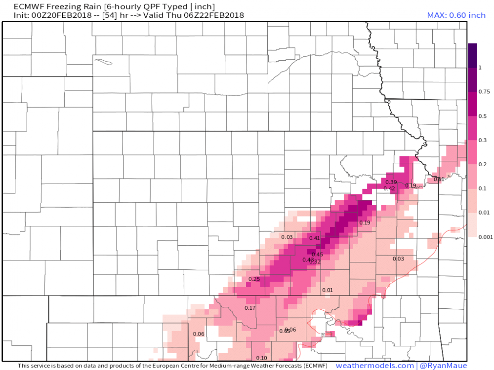
To your point, the Euro is showing Ice Storm warning totals across the Kansas Turnpike corridor on Wednesday night into Thursday morning:

.png.5e33c6ba15c2b8c2b63a2738f31c091c.png)

MO/KS/AR/OK 2019-2020 Winter Wonderland Discussion
in Central/Western States
Posted
If the latest NAM/Euro/Canadian models are right...that will have to be shifted west and increased.