

rockchalk83
-
Posts
364 -
Joined
-
Last visited
Content Type
Profiles
Blogs
Forums
American Weather
Media Demo
Store
Gallery
Posts posted by rockchalk83
-
-
7 minutes ago, StormChazer said:
18Z NAM looking colder.
A little slower, too? Or are my eyes deceiving me....
-
14 minutes ago, MUWX said:
It’s fairly consistent with where it wants to take the low, which may give it some credibility, but it’s normally too cold so I don’t know what to make of it here.
The Canadian has been in the camp of ejecting out a little quicker and farther east than most models. It ultimately ends up being weaker (to some extent) and it has a broader energy envelope. Sensible impacts remain the same, just shifted east from where consensus has it.
-
1 minute ago, The Waterboy said:
I could be incorrect but the track of the surface low (especially on the 12z NAM) seems odd. It runs from Brownsville to Houston then due north from Dallas to Tulsa. Not saying it won’t happen that way but it isn’t typical from what I recall.
Our best track for snow is roughly Houston to Shreveport to Memphis. Doesn’t look promising. To Jomo’s point, if the west trend continues, frozen precip may end of west of OKC and Wichita.I thought the same thing, too. When looking at the 500 mb vorticity, it really gets wrapped up and moves farther west as a result. I'm inclined to think it won't get *that* wrapped up and track farther west, but some of the ensemble members in all the suites are showing this, so it's a trend to watch.
-
 1
1
-
-
12z RDPS continues the theme of an ice storm from central OK through Missouri. Quarter to two-thirds of an inch of ice possible if that run verifies.

-
14 minutes ago, JoMo said:
At this rate, it may end up west of you...

Don't say that. Some places in southwest Kansas have had 30 inches of snow already this year. Wichita has had about 2 inches.
-
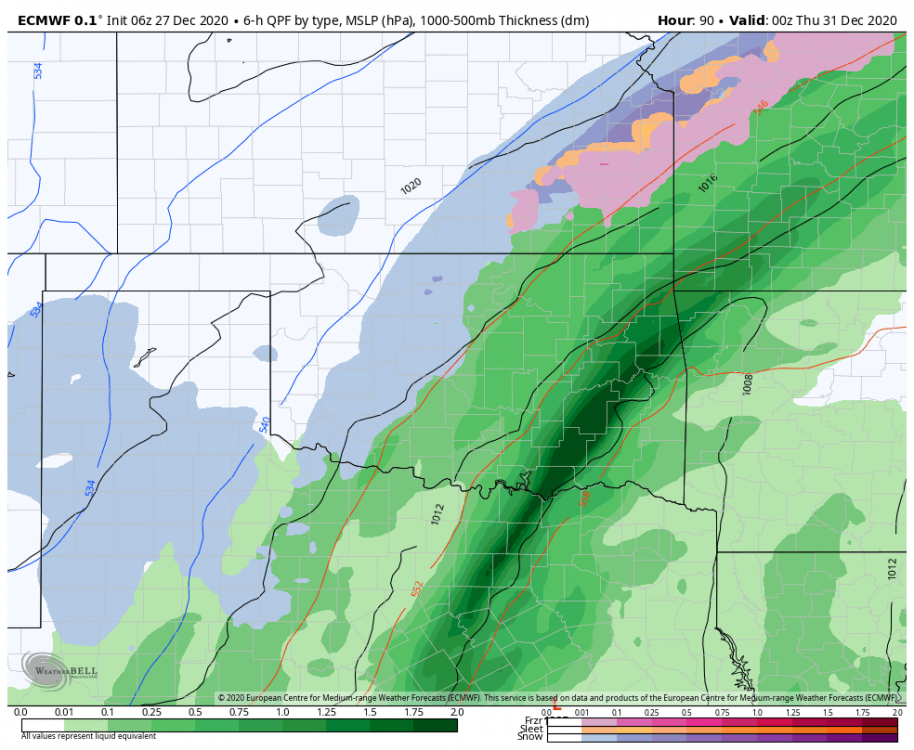
06z ECMWF, 06z ICON and 12z NAM have shifted west with the storm. Would like to have it be 2-4 degrees colder because if not, someone is going to get a helluva ice storm.
Nice stripe of snow on the backside, too.
-
27 minutes ago, JoMo said:
Well, that was fun, next... lol
The 12z GEFS is not as warm for SW Mo as the op run. There is hope?
-
There was a discernable shift west in the 00z Euro & 06z GFS ensembles (stronger and somewhat slower), while the 06z Canadian Ensembles and the 12z NAM keep everything a little more open and to the east.
The trend has been for stronger systems out here this year, I wonder if this will continue? -
18 minutes ago, StormChazer said:
So FWIW here was the 6Z Euro.
definitely more snow on the back end already.
How far out does the off-hour ECMWF go out to? Would be interesting to see how this progressed.
-
17 minutes ago, The Waterboy said:
12z CMC is interesting...
Can we lock that in, please?!?
-
28 minutes ago, JoMo said:
Wouldn't really make a difference, the storm system just wraps up too far west on the GFS. It needs to be more of an open positive tilted trough until it gets south of us, then it can wrap up. Anything else and the warm air is going to probably overwhelm the cold air sitting in place.
Good point. I didn't even think about where it would wrap up. The 12z Canadian shows a scenario where it wraps up across Oklahoma (500 mb level) and brings warm air into much of the region. Ice and snow storm for central and western Kansas. A small step toward the GFS, for sure.
-
17 minutes ago, JoMo said:
At this rate on the 12z GFS, we may have to watch out for severe weather. Nice Nebraska snow though.
In comparing the 12z GFS to the 00z Canadian and 00z Euro models, it appears the high pressure (modeled to be 1038-1042mb) is one of the keys to watch. All the models agree on a diffluent southwesterly flow with a lee-side low (modeled 999-1003 mb) developing, but, the degree of warmth is predicated on where the high pressure sets up and how strong that low is.
If it's over MN, then we're looking at a big winter storm. Over southern Ontario, then we're looking at rain and storms.
How have the models handled cold air masses so far this season?-
1
-
-
5 minutes ago, StormChazer said:
Here you are!


Thank you! Its very interesting that a decent number of members plastered the region with big snows and the outliers were dry.
-
1
-
-
1 hour ago, StormChazer said:
FWIW, here is the mean 48 hour snowfall of the Euro members yesterday at noon to midnight last night.
BIG JUMP
12Z Yesterday

00Z Last Night

I'd be interested in seeing the individual member breakdowns to see if they are as robust as the op run? My feeling is that the heft from the op run contributed to the big jump in totals in C KS.
-
The 3KM NAM with a little different look than it's traditional counterpart.
The biggest headache with the forecast is going to be where the system matures...along and northwest of that point, is going to be where the heaviest snow falls. Unfortunately, we may not know that until the high-res hourly runs tomorrow, even though the system will be fully sampled in later model runs today.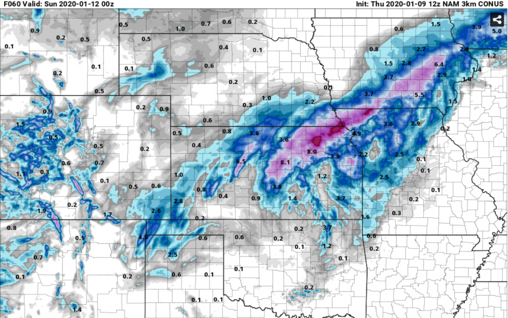
-
I'll agree with MUWX's assessment that the bulls eye right now is between I-70 and I-44. Something to keep in mind here is that this isn't the typical winter system we have out here, where we have a huge low coming out and a large precip shield. Rather, this is a rather weak low and the event will be driven by warm air advection processes. The whole forecast is going to hinge on where the baroclinic zone sets up, as that will be the axis that sees the 2-8" snows.
Overall, for it being >3 days out, the models have a good agreement on some type of winter storm out here this weekend. It will be nice to see some snow over a widespread area, since most of us have been dry for a while.-
1
-
-
On 3/8/2019 at 11:20 AM, andyhb said:
Paul Roundy was my OU advisor's phD advisor. This is another shot across the bow regarding this upcoming severe wx season.
If the mean trough is in the Southwest US, wouldn’t that mean more severe weather for our region?
-
4 minutes ago, JMT417 said:
Can someone center this on MO for me to see? thanks in advance
Here you go:
-
1
-
-
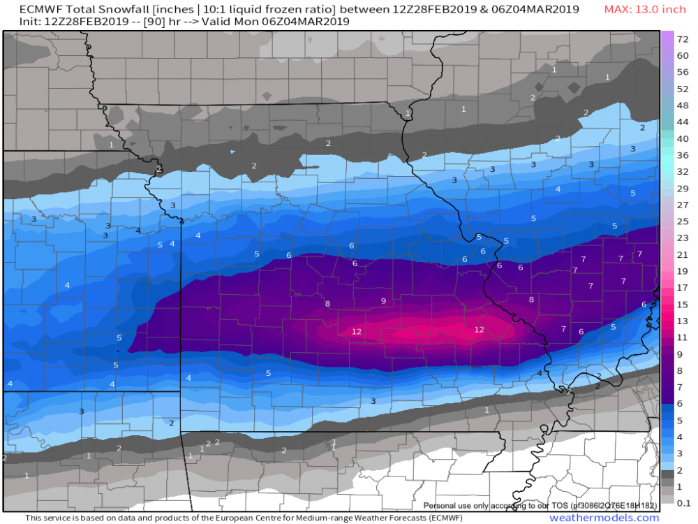
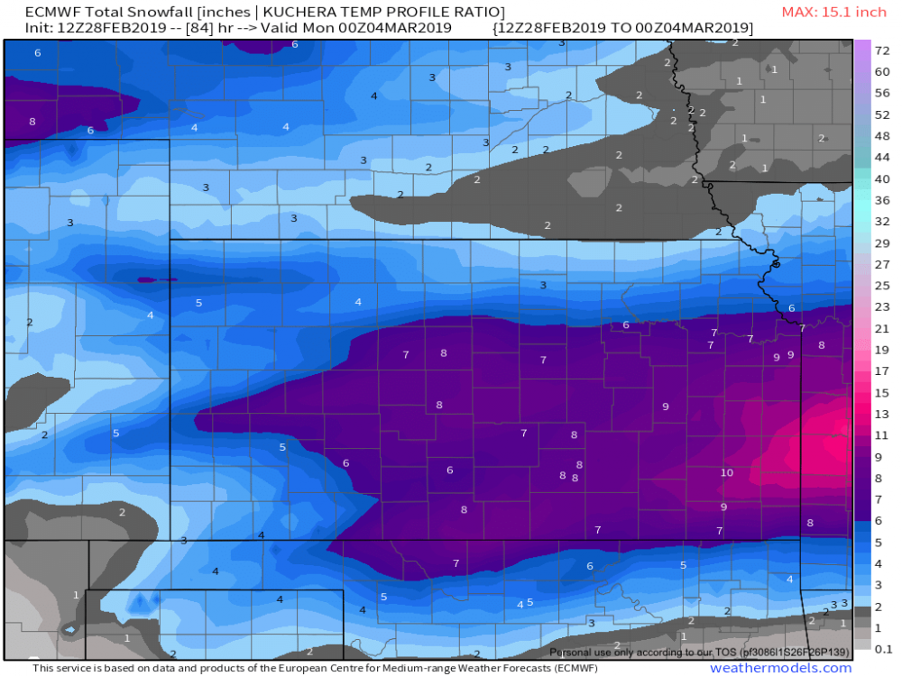
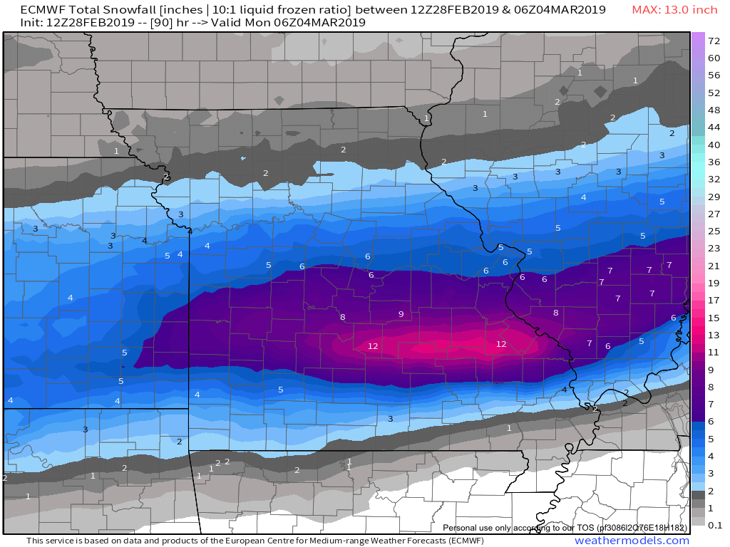
Here is Kuchera snowfall off the Euro:
-
3 hours ago, StormChazer said:
If anyone was wondering who got it good yesterday.
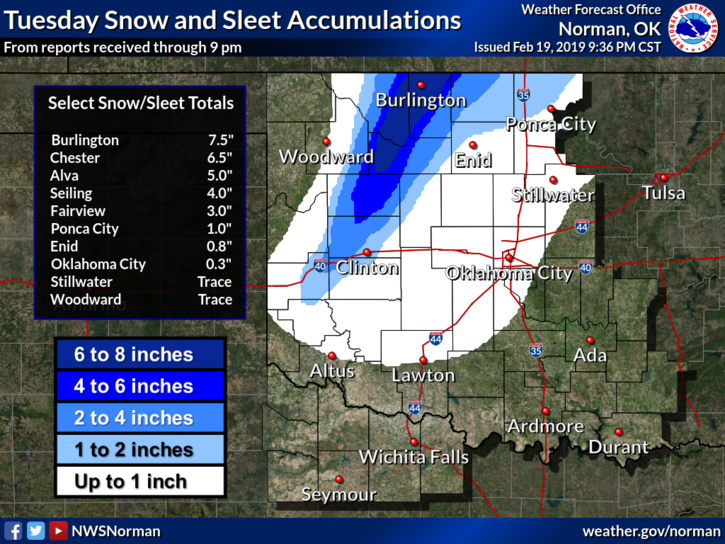
Some places in SC KS got 10 inches of snow. The town of Kingman, just west of Wichita, picked up 3 inches in one hour as a band really intensified overhead. This banding feature was really well forecasted, starting with the 18z NAM on Monday and continuing throughout the event.
-
1
-
-
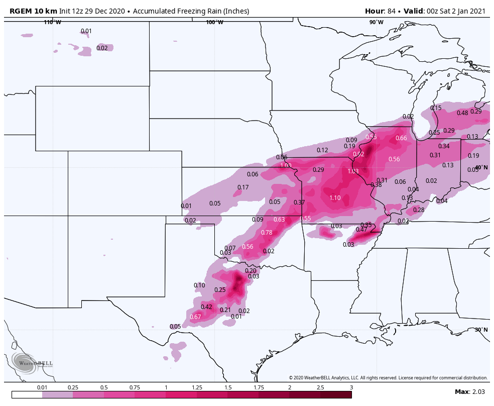
Seeing ice storm warnings go up for the KC and Joplin areas...and it's possible those could be expanded south and west later. HRRR, RAP & ECMWF all prog significant freezing rain event (>.2") in C & E KS into NW MO tonight.
Meanwhile, storms going up south of the stationary boundary in C OK. -
Just now, wxeyeNH said:
Several days ago it had temps in the single numbers falling to below zero at end of game. Sure warmed up significantly out there
The storm system won't be as deep as it moves through my part of the world...in fact, it's likely to be an open wave. The upshot of that is not as much cold air on the backside. Temp guidance for Sunday has warmed 20-25 degrees since Tuesday.
-
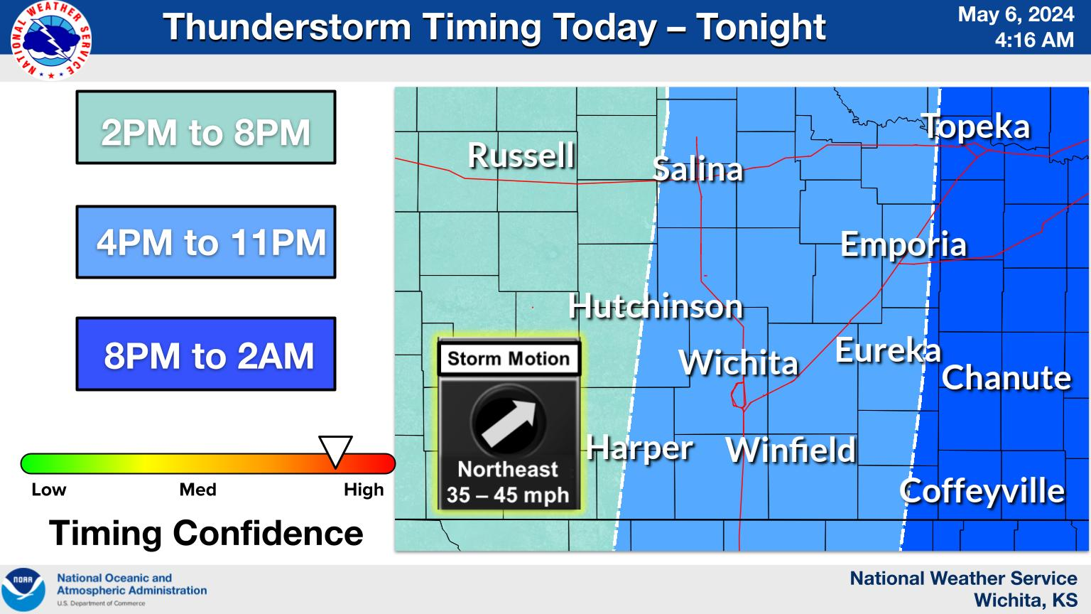
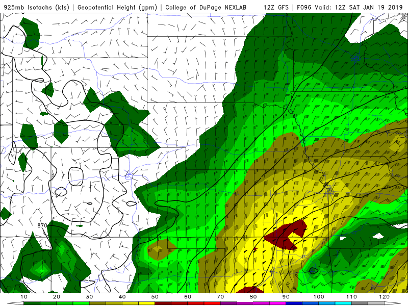
19 minutes ago, Wx 24/7 said:
Someone is going to get slammed with the weekend storm. Chiefs fans... it may be harder to sit through the game this weekend at Arrowhead... with snow and temps in the single digits and below zero wind chills. Yikes.
Here's a look at 925 mb winds based off the GFS for Saturday morning at 6 am. The red indicates winds at 50-55 kts about 2000 feet off the surface. If this verifies, then we may very well have blizzard conditions across C & E KS into parts of West Missouri.
-
1
-
-
3 hours ago, RocketWX said:
Well here in Wichita, I'm certainly curious to see what the Friday/Saturday time frame can do. Last nights ECWMF run certainly caught my attention. I'm not holding my breath as we have been missed from all sides this year. However, when the Euro says something I typically listen. Still 5 days out though, so we'll see if it remains consistent over the next few days.
Agree with this. When you look at the winds that are progged behind the cold front, we could very easily have blizzard conditions over a wide area if this comes to pass.
FWIW, the 12z GFS ensembles had a much snowier solution than the operational run.-
1
-


MO/KS/AR/OK 2020-2021 "Winter" Discussion
in Central/Western States
Posted
One thing to watch will be if a large complex of storms can develop in the warm sector, thereby pulling the system southeast and, perhaps, limiting accumulations of ice/snow.
The waffling will continue, obviously, but I think going forward, that's going to be where the game is played.