

rockchalk83
-
Posts
364 -
Joined
-
Last visited
Content Type
Profiles
Blogs
Forums
American Weather
Media Demo
Store
Gallery
Posts posted by rockchalk83
-
-
23 minutes ago, JoMo said:
There's a little more light snow action in KS and N OK on the 12z Euro with the first system but it's also going to miss as well.
Looks like a 1-3" event here Friday into Saturday, but a more substantial event for the late weekend period. This does appear to be a more aggressive run of the Euro, so we'll see what the ensembles say.
-
The 12z GFS Ensembles backed off on the amount of precip with the weekend system, but still has >6" for most of our area in the next 240 hours.
Let's see what the Euro does. -
22 minutes ago, StormChazer said:
FWIW the 12z NAM is looking similar to the GFS in terms of the upper air pattern.
Will have to see what the new GFS is going to show.


If anything, the NAM looks a little more bundled and deeper with the energy than the GFS does...at least that what my eyes tell me. I think the runs today and tomorrow will be interesting to see which side wins out here.
-
12 minutes ago, MoWeatherguy said:
How have the Euro weeklies been this year u ask? Well, here you go. Top pic is the current weeks forecast from a month ago. Next pic is the newest forecast, same time period.
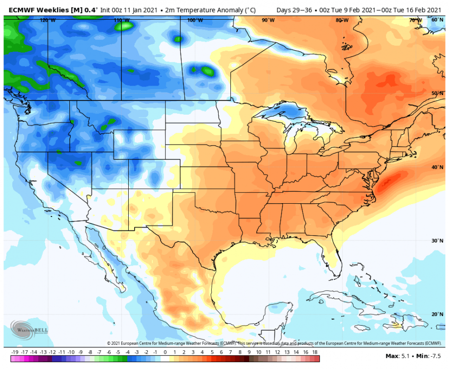
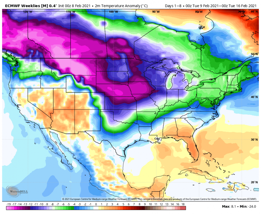
Not good, Bob. I wonder why the major change? I wonder if there was a major wave buckle in the Pacific that led to the pattern change?
-
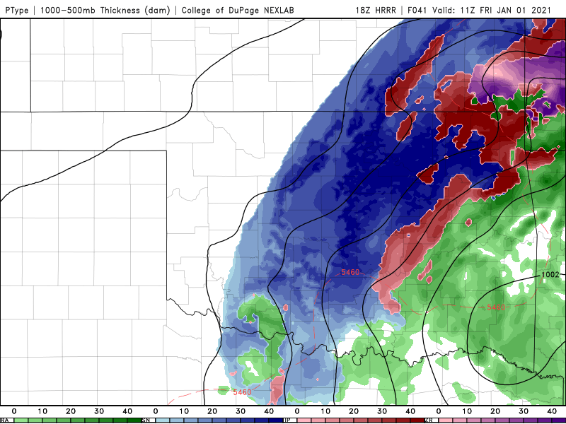
33 minutes ago, StormChazer said:
Kuchera amounts for S&G.

It’s quite possible that I’m salivating after looking at that.
-
 1
1
-
-
6 minutes ago, Solution Man said:
Temperature as mentioned earlier....way under done. The cold air continues to seep south. Highs today here (Platte City ) are predicted at 15F. There is no way we make it there as we currently sit at 5F -SN. This is pure arctic air!
The forecast high for Wichita today is 18. We've had light snow all morning long (snowing at a decent clip right now)...there's no shot we get to 18 if this continues. Temps falling into the single digits 30-40 miles north of here.
And as for the 12z GFS, if that's crazy....sign me up! If we're going to go big with the cold, let's go big with the snow.-
1
-
-
I’m not near my computer to look, but are the GFS and Canadian still showing snowy and cold solutions?
26 minutes ago, JoMo said:Well, the 12z GFS and 12z Canadian aren't following the 00z Euro. Maybe just a wonky run?
-
4 minutes ago, lokee said:
06 GFS and )6 GFS 16 coming aruond
To what?
-
Still snowing hard here. 6" and we're snowing at 1-2"/hr again. Winds are picking up, too, so we're seeing whiteouts.
-
1
-
-
28 minutes ago, JoMo said:
So which model do you all think consistently performed the best? I think the RGEM and GEM didn't do that bad of a job.
The Euro/Canadian sniffed out the overall trend first. Feel for SC KS, the Euro did the best. Short term models were a little too far southeast with the heaviest band.
-
Started snowing here in Wichita about 4 am...have picked up 4" (2" between 7 & 8 am) and it's still snowing. Biggest storm since 2014.
-
2 hours ago, RocketWX said:
I hear you rockchalk. I live just southeast of Wichita right on the Sedgwick Butler county line and it feels like it's been forever since we've had a snow that completely covered the grass. This has been a fascinating storm to track and I'm hoping it snaps that streak. A few things I'm watching: Are the Hi Res models showing that eastward shift of qpf on to something? How quick will the changeover to snow occur? I still think there is merit to a heavy band of snow developing somewhere in this area that could over achieve and drop 6"+ even though we are only in a Winter Weather Advisory.
I am right there with you on all those points. One other question I’ll throw in is how far west does the main deformation precip shield get. I have a hard time buying the razor thin cut off that some are showing, but that may just be wishful thinking.
The latest model runs give me even more pause that the streak won’t end tomorrow, but it’s time to nowcast this out and see how it evolves.
Good luck and happy new year to all! We survived 2020.
-
Just now, Solution Man said:
Good luck my friend, I think it will pan out
I hope you’re right....but I’m naturally pessimistic. 7 years of little snow does that to you. Haha.
-
17 minutes ago, Solution Man said:
Looking good for K.C. area.
Tight rope for Wichita. If we get >4” of snow, it will be the biggest storm in almost 7 years. Insane.
-
Just now, The Waterboy said:
The difference between the 00 HRRR and NAM are crazy. Significant SE shift on the HRRR. Hummmm...
The NAM, GFS, and Euro have been ultra consistent...
-
1 hour ago, The Waterboy said:
Does “sharper upper level trough” mean further west? I’m not sure how to interpret that.
It implies the system would be stronger and potentially take on a negative tilt.
-
 1
1
-
-
Interesting note from NWS Norman regarding the 12z model initializations. FWIW, the 21z RAP edged west with the main precip shield, while the 18z Euro maintained.
The complicating factor with this forecast is that for precipitation
amounts and types with the cyclone, the models widely diverge in
solutions and the impacts that result from the solutions. In
discussions with WPC, the GFS/NAM 12z initialization had a 30 meter
initialization error in the 500mb height fields, which should have a
sharper upper-level trough. For this forecast more weight was put
towards the ECMWF solution for precipitation location and type,
however the forecast for precipitation type/impacts could
drastically change with any shifts in path of the cyclone.
-
11 minutes ago, StormChazer said:
I will give up weather if that happens. What a close shave!
-
 1
1
-
-
FWIW, the 12z HREF from the SPC is fairly similar to the Euro in track and slightly colder. It has a wide area of 1/4-1/2" ice across SE KS, SW MO and NE OK. With the wind that's forecast with this, power outages are going to be a distinct possibility.
-
2 minutes ago, JoMo said:
The 12z Euro is a bit cooler and a bit more SE. Gonna be close to the freezing rain here, hopefully it stays just north.
That's a big area of heavy freezing rain on the Euro for 12z Friday. Yikes.
-
It is interesting to note that the short-term models (granted, they're still just coming into their respective time domains) do not have the system as far west as the ECMWF, GFS, ICON models. Just a slight nudge east.
Will be interesting to see if that trend continues as the system gets into better focus for the high-res models. -
Looks like model initializations were all over the place on the 00z suite of runs. It is interesting to note that the 06z HRRR (48 hrs) was among the colder of the models, with a larger area of sleet and snow.
Will be something to follow today as that could significantly ratchet up snow totals for western Oklahoma into Kansas. -
1 hour ago, StormChazer said:
Can someone more meteorologically inclined than myself answer this question?
If this system drops 4-5 inches of snow to the NE of Tulsa in a line parallel to the front, can that snowpack actually push the freezing line forward the next day further than if it didn’t snow?
Generally, if the snowpack falls over a wide area, it can act as a refrigerant (lack of a better phrase here) to lock in the cold airmass. In this instance, the winds are coming from the south and there will be intense theta-e advection over the cold, which may actually enhance the potential for icing.
-
1
-
-
46 minutes ago, Solution Man said:
Not bad

We take.

MO/KS/AR/OK 2020-2021 "Winter" Discussion
in Central/Western States
Posted
Just downright nuts.