

rockchalk83
-
Posts
364 -
Joined
-
Last visited
Content Type
Profiles
Blogs
Forums
American Weather
Media Demo
Store
Gallery
Posts posted by rockchalk83
-
-
48 minutes ago, RocketWX said:
Going to very curious to see the final totals for this storm. Everytime I look at trends it seems be ever so slightly deeper and south when it comes to the ULL. 24 hrs ago I thought I may not get an inch here in Wichita and now I could see areas very near Wichita waking up to a decent snow. Combined with the winds could be a huge mess.
Rain is changing to snow in Newton and Goddard, won’t be long for us. Gonna be an interesting night.
-
 1
1
-
-
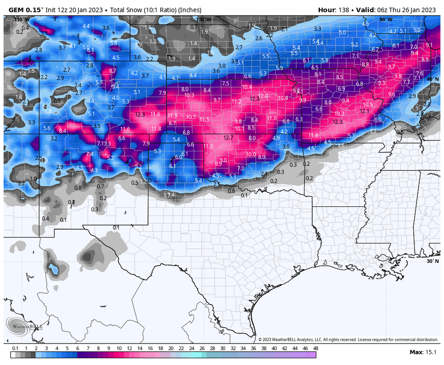
Meanwhile, the 850 mb low for this current storm system was analyzed 100 miles farther south than modeled. High-res models have been trending up on this current threat this morning. But farther west from where @RocketWXand I are...it's a full scale blizzard in Western Kansas.
-
1
-
-
42 minutes ago, andyhb said:
I think it's more likely for the Friday system to get suppressed south/shift too weak than cut that severely. That -NAO block is stout.
Do you think the MON/TUE system will shift south? In reading the AFDs from DDC and ICT, their mets seem to think so.
-
New wrinkle from the Euro on this latest run, it cuts off the upper low as it strengthens during the day Monday (similar to the 00z GEM). Looks to be a colder and slower solution, too.
Of course, the end result will likely be a blizzard for some portion of Kansas/N OK.
EDIT: Holy boats, this 00z Euro run is pure weather porn.-
1
-
-
GFS appears to be much slower and slightly deeper this run. 500mb low deepens as it moves east across western Oklahoma. Decent hit for Kansas, with strong winds….
-
We have about 3” on the ground here in Wichita. Roads are all gummed up.
Has anyone checked out the models this morning on storm #2?
-
58 minutes ago, JoMo said:
Looks like some snow or snow to rain for some folks on Friday morning with a weakening system and a bigger system on Monday-Tues (8th and 9th) which is still uncertain. And probably more systems after that to watch.
Definitely looks like we **could** have a decent event here in SC Kansas. Local NWS mentioning a cooling trend in the temp profile and models seem to be latching onto a weak TROWAL signature. We'll see.
-
1
-
-
Once we get past the 4th of January, the pattern looks to get more active. Can’t wait to see how this develops.
-
2
-
-
7 hours ago, RocketWX said:
Just on the southeast side of Wichita and received roughly 7". One of my favorite snows of all time. Beautiful snow with large flakes and very little wind. Great start to the 2023-2024 winter as the moisture is much appreciated around here.
I finished with 8” here on the west side of Wichita. A beautiful snow, and hope there’s more coming this winter.
-
2
-
-
7 hours ago, JoMo said:
So the GGEM/Euro did the best while the NAM was just awful like usual, right?
I'll admit, I fell hook, line and sinker for the NAM. Especially once the 3KM NAM got within 48 hours and it was pumping out 3-5" totals for S KS. And for a time yesterday, it looked like we were going to get that...but, marginal temps means just more moisture in the ground.
-
Storms in warm sector of these storms always tend to rob the moisture from the snow side. It's something the models struggle mightily at trying to predict.
Take what we can get, though, we're still in a drought after all. -
10 minutes ago, RocketWX said:
Currently a very pretty snow just on the southeast side of Wichita. 34deg on the weather station though, so what's falling is melting.
There's a moderate band of snow between us & the OK/KS border, we should see the ground whiten up in that band. Hope the precip fills in south of Enid.
-
Given that we aren't seeing much of a changeover in western Oklahoma and that same precip shield is moving into S KS faster than expected, I'm wondering if don't end up with higher totals similar to what the NAM has shown?
Would be a boom forecast out here for sure.
EDIT: The 12z HRRR/3KM and 12KM (Regular) NAM both agree on 3-5" amounts out here.-
1
-
-
Advisory out for south-central and southeast Kansas. Looking for 1-3" in metro Wichita, with higher amounts southeast of the Flint Hills.
Though, the NAM may be onto something... -
Break out the sad trombone for the southern Kansas folk. It's too warm for snow the system today, and the storm for Tuesday/Wednesday looks to be too far south to do anything, unless there's a drastic shift north.
Bummer. On the plus side, western Kansas (where the heart of the D4 drought is,) is getting some much needed snowfall.
Onward.
-
1
-
-
10 minutes ago, RocketWX said:
Well I suppose I'll finally chime in after model watching the past couple weeks, watching systems either fall apart once inside the 180hr range or track north of me. Today seems to be first day that all models are starting to align on how this system is going to eject into the plains. Should be fun to monitor over the weekend. At this time, everything seems on the table here in ICT, from a complete miss to the south to one of the better snows we've had in a while. I do like that the track is south at this time, as these tend to trend north when it is a strong system like currently modeled. It wouldn't take much of a shift to get in on some of the higher qpf currently over Oklahoma. Here's to hoping we all cash in some how.
This 100%. Finally nice to see something around here other than tumbleweeds and duststorms.
-
2
-
-
Looks like thru hour 72 of the Euro, it's stronger with the 500 mb low in northern Arizona than it was on 00z run. There's a 537 dm circle centered near the AZ/NM line.
So far, the trend overall with this run has been for a stronger, slightly farther north, system.-
1
-
-
The Canadian model holds serve from its past several runs (this is combined for both tomorrow's and the Tue/Wed storm). Now we wait for the Euro.
-
I have a hard time buying a foot plus to the I-44 corridor with marginal temps like the GFS is trying to sell. It's trying to do produce 3 inches of snow here in SC KS tomorrow with temps of 34-37 degrees.
That said, dynamic cooling is an equalizer. -
Just glanced at the 18z Euro Ensemble and it trended stronger and more northerly with the 25th system. Would be a decent hit for most here.
-
1
-
-
20 minutes ago, StormChazer said:
BIG fan of that Euro run.
Color me intrigued
-
39 minutes ago, StormChazer said:
Maybe another quick burst of snow Sunday morning? Hoping something comes of the 25th.
Looks like models give N OK 1-2" of snow Saturday night into Sunday.
Not sure what to make of the storm aoa the 25th. Each model shows the range of possibilities with this. Upper lows that dig south across the Rockies are tricky. -
We're down to 1/8 mile vis here in Wichita, heavy snow, blowing snow, fog. -5 with a wind chill of -32. North winds to 50 mph, but we've gusted higher. The -32 wind chill is the lowest reported value here since 2000. First snow squall warning issued for our area this morning.
We won't verify a blizzard in all likelihood, but this has been one gnarly ass storm.
-
1
-
-
16 minutes ago, MUWX said:
Starting to see some very faint returns on radar. I think we’re gonna have a decent period of freezing drizzle before the snow starts.
We have had light freezing drizzle/snow grains most of the day here in Central Kansas. It's the lift ahead of the front. Once that passes, it should be over.
MO/KS/AR/OK 2023-2024 Winter Discussion
in Central/Western States
Posted
A little concerned the ensembles remain drier than the operational runs and we see a drying trend in the operational models over the next couple of days. Especially with the volume of cold air coming.
Either way, dangerous weather is coming with the combo of dangerous cold and atleast some snow.