

HeadInTheClouds
-
Posts
1,598 -
Joined
-
Last visited
Content Type
Profiles
Blogs
Forums
American Weather
Media Demo
Store
Gallery
Posts posted by HeadInTheClouds
-
-
19 with moderate snow.
-
It started snowing up here 20 minutes ago, now a steady light snow with a dusting, temp 20.
-
Just overcast here in mid hudson valley. 21/3.
-
18/2, feels like snow.
-
1 minute ago, Brasiluvsnow said:
anyone care to guesstimate a start time for this ? 4 pm ?????
For you in Rockland probably between 2 and 3pm.
-
 1
1
-
-
3 hours ago, Snow88 said:
Temps before the storm are much colder than past storms
You aint kidding. 18 here right now with a forecast low of 7 tonight and high of 28 tomorrow.
-
-
35 minutes ago, Juliancolton said:
While this mostly concerns interior areas where p-type isn't as much of a worry, it's worth noting that although QPF has increased a little at 12z, the soundings also got a fair bit worse for snow growth. It may cancel out. That's a lot of lift and vertical real estate now focused in the riming layer with the warmer mid-level temps.


Yes, and I think 3-4 inches is still a good call for us in Mid HV. I would be surprised with anything more than that.
-
 1
1
-
-
-
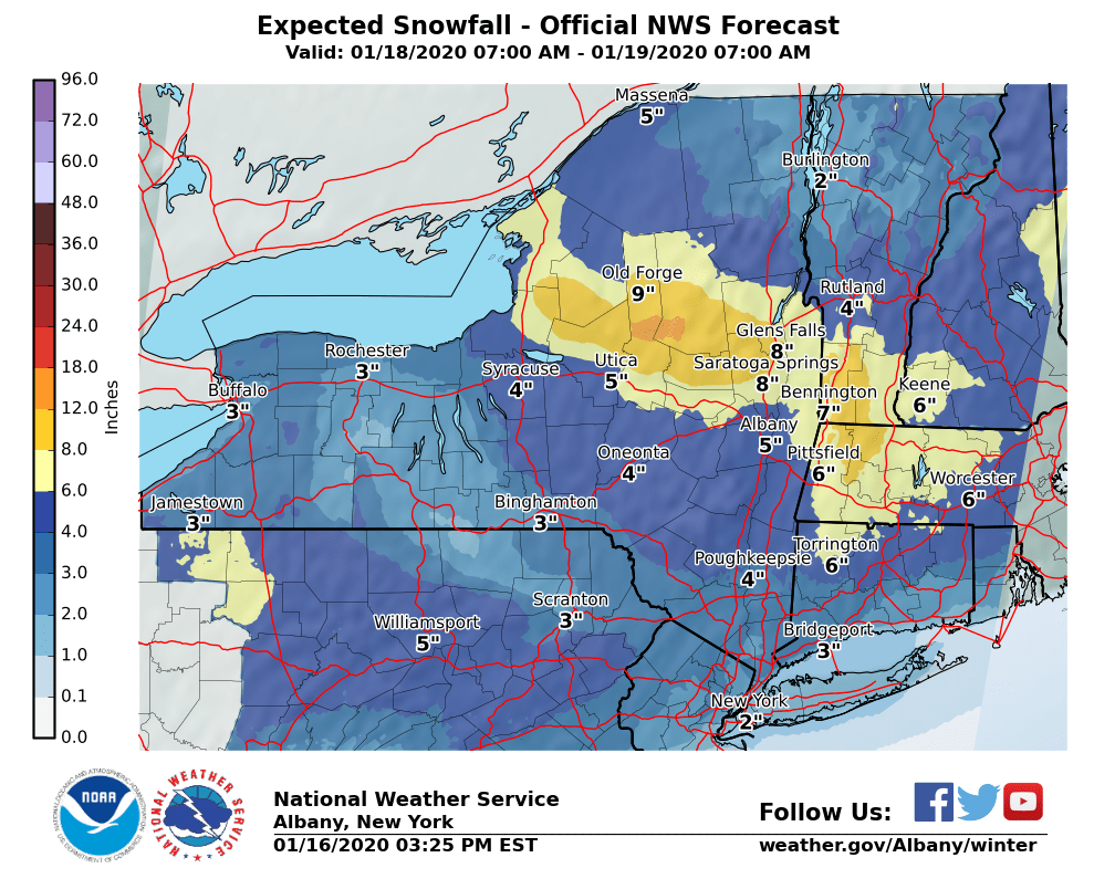
Latest discussion from NWS Albany below. Looks like 3-5 for most of lower and mid HV. North of I90 get 6+

A fast moving storm with favorable jet dynamics will bring a
widespread moderate to heavy snowfall to the region. A cold airmass
will be place across the region ahead of this storm. There will be
impressive insentropic lift with strong frontogenetical forcing.
CSTAR research indicates banding will be possible. Laterally
translately bands occur with strong warm air advection and the
low approaching from the west. Overrunning warm air advection
snow will quickly spread across the area early Saturday
afternoon. Once it starts expect it come down heavy with
snowfall rates of 1 to 2 inches an hour. The bulk of the snow is
expected to fall between noon and midnight. The highest
snowfall amounts are expected across the southern Adirondacks,
lake George Saratoga Region, Berkshires and southern Vermont
where 7+ inches are expected.

Secondary development is not expected to occur until Saturday night
and off along the northern New England coast. So our snow will come
from the primary low and with the southerly flow ahead of it some
mixing with rain possible into the mid Hudson Valley and
northwestern Connecticut late Saturday evening however the dry slot
should also be moving in at the time.
-
2
-
-
There is going to be a time frame from early afternoon until early evening when most if not all accumulation will happen. I still think central park sees a slushy inch or 2, just north of NYC 2 maybe 3, then further N and W into NW Jersey and HV 3-4, isolated 5.
-
Same here, 33 and moderate snow.
-
6 minutes ago, NYCweatherNOW said:
Okay I’m sorry if you guys feel that way
I don't. Keep up the positive vibes.
-
2
-
1
-
-
I think most locations including my area in HV are going to get their snowfall in a 3-4 hour period from early afternoon to dark, then mixing and/or a reduction in precip intensity will occur. IMBY I'm thinking 3-4 is a good call right now.
-
10 minutes ago, Brian5671 said:
the city is not getting 6 from this. Maybe 2 to possibly 3 inches. (which would be a huge win)
Who said the city is getting 6? 2 inches though is a definite possibility.
-
 1
1
-
-
Still looking like 2-4 30+ miles north and west of NYC.
-
Can somebody post Euro snow map if possible?
-
Was it ever going to be more than a 1-3/2-4 event for the coast? Not really. It's looking like a 3-6 event by me north of 84. It was 68 degrees last weekend so I'll take it and run.
-
2
-
-
NWS Albany latest discussion on the storm. Right now looking pretty good 40-50 miles N and W of NYC.

Active winter weather expected to return on Saturday, as a primary
cyclone is forecast to track from the Midwest to the lower Great
Lakes. Southerly flow and isentropic lift will increase in our area
ahead of the eastward advancing cyclone. Model guidance in fairly
good agreement with regards to the track/intensity of this system.
There is increasing probability for a moderate to heavy snowfall
across much if not the entire region, as both 12Z deterministic and
ensemble guidance support this trend. Guidance indicating a Miller
Type B system, with a secondary coastal cyclone developing Saturday
night near SE New England. At this time it appears most of the
precip in our area would be from the primary cyclone. With the
southerly flow regime at 925-850 mb, local research indicates the
maximum snowfall to set up across the southern Adirondacks, the
Glens Falls/Saratoga region and the southern Greens of VT. While
thermal profiles have shown a cooling trend, there could still be a
chance of mixing for areas SE of Albany Saturday night as thermal
profiles become borderline as the primary cyclone tracks just north
and west of our area. Still too early for specific snow accumulation
numbers, but will mention possibility of moderate to heavy snowfall
in the Hazardous Weather Outlook.
-
2
-
-
I'm having trouble connecting to tropical tidbits. Anybody else having this problem?
-
6 minutes ago, snowman19 said:
The area NWS Albany covers is not part of this subforum
Dutchess county is certainly part of this subforum. I'm 75 miles north of NYC, not near buffalo.
-
3
-
1
-
-
1 hour ago, snowman19 said:
Upton is not buying snow for Saturday, no CAD evident, new disco:
Temperatures will be remaining above normal through Thursday, then
return to more normal levels Thursday night into Sunday as Arctic
high pressure builds toward the region.

Any precipitation with the waves will be mainly in the form of rain.
For the system next weekend there is some uncertainty as to how long
a period of light snow will occur before a transition to all rain
Saturday afternoon. This will be dependent on how quickly the cold
air is scoured out as high pressure moves east. At this time there
is no cold air damming evident and the flow does remain progressive.
Also there is uncertainty with temperature profiles with the ECMWF
warmer than the GFS. With these uncertainties will keep the
probabilities at chance.
Not everybody on this board lives in NYC and Long Island. NWS Albany discussion below:
By Saturday morning, the high sets up in a prime position across
Quebec. An upper-level trough and surface low forms across the
Plains and heads eastward. The current track of the surface low is
across the Upper Great Lakes on Saturday before the energy transfers
to a coastal low late Saturday into Sunday. Cold and very dry air
ahead of this system raises confidence that wet-bulb effects would
lead to a nearly all snow event. It is possible that warm air aloft
brings a brief transition to sleet/freezing rain and/or rain from
near the Capital Region south; however, confidence on this is low.
While this is several days out, good ensemble agreement led to
raising the PoPs to likely. A plowable snow is possible.
-
5
-
3
-
-
14 minutes ago, CIK62 said:
Something better happen and fast around here---or NYC will be known as Global Warming Capital. GFSx for the next 6 days is +17 at 49degs. [Back to Nov. 12, in other words] Even using day 7, which it claims will be the start of the colder period, the average T is still 47degs., or +15.
I got to 37* briefly today, at 3:30pm. Felt like it was a 'March style' 37 too, while strolling around. Tomorrow at this time it will be 15degs. warmer than that.
Getting squished. Y or N?

https://www.cpc.ncep.noaa.gov/products/predictions/814day/814analog.off.gif
Use the link. Something missing on the government website.
We all know the next 7-10 days are going to be above normal. Whats your point? It looks to get much colder after that though. BTW today I had a low of 17 with a high of 29. Felt like January to me.
-
1
-
1
-
-
12 minutes ago, Brian5671 said:
wonder if someone could put up a +35 this weekend? Saturday Nightime lows alone are close to record daytime highs
I may be close to that. My normal split is 35/15 and I may be looking at a 65/55 this weekend.
.png.a80929c70faf247c77488283e53d9f4a.png)
Wintry mix potential weekend of Jan 18-19, 2020
in New York City Metro
Posted
22 with moderate snow. 2.5 OTG.