

HeadInTheClouds
-
Posts
1,663 -
Joined
-
Last visited
Content Type
Profiles
Blogs
Forums
American Weather
Media Demo
Store
Gallery
Posts posted by HeadInTheClouds
-
-
00z CMC very similar to 12z. Woof.
-
2 minutes ago, eduggs said:
That's how it looks to me too. And the key features are only 4-5 days out from being in their critical locations, so there's not a ton of time for changes. But things could still evolve differently, so we'll all probably continue to track.
Unfortunately it's going to take a lot of evolving to move this baby east 1000 miles especially when all models are way west.
-
 1
1
-
-
19 minutes ago, wishcast_hater said:
7 days out. Just saying.
.It's over. These storms that cut like this don't trend east. It's not an inland runner. It's a strong low setting up shop in the midwest.
-
 1
1
-
 2
2
-
-
2 minutes ago, White Gorilla said:
The cutter solutions this far out often stick to verify because there is so much geographical freedom, possibilities for warm, rainy solutions...... 100 miles west or 1000 miles west or anything in between. For a snowy solution, you have such limited margin for error with track.
Yes, I was just saying the GFS is normally stubborn and doesn't cave so quickly to other models no matter what the scenario. It usually takes a few days and not just 1 or 2 model runs.
-
1
-
-
6 minutes ago, Rmine1 said:
Hard to call it winter with such warmth and liquid precipitation
It hasn't been warm. I haven't been past the mid 30's for highs in a week and hit a low of 10 this week. December will likely finish average or slightly below average. It just hasn't snowed as much as we would like.
-
1
-
-
Well that didn't take long for the GFS to partially cave. It usually takes a day or 2 at this timeframe.
-
 1
1
-
-
1 minute ago, Franklin0529 said:
Snowman19 probably laughing right now
Yup. He's lighting a cigar as we speak.
-
2
-
 3
3
-
-
Just now, Winterweatherlover said:
The GFS didn't really cave in todays storm until 12 hours out so idk if I'd rely on that.
I was only kidding but it will still eventually cave. This weeks storm isn't close to the differences in next week's. It was more thermal and nuances with topography, elevation, downsloping, etc. The differences in next week's storm are huge.
-
6 minutes ago, SnoSki14 said:
Very dramatic changes. I think we need to see a few more runs before saying it's done.
Or until GFS eventually caves. Whichever comes first.
-
45 minutes ago, Nibor said:
If you take model output at face value you’re gonna have a bad time.
I don't and it's not just model output or this one particular storm. It's just a bad model that has had worse results after an upgrade. It's far worse than both the Euro and CMC. Look at what is happening with next week's storm.
-
1 minute ago, MJO812 said:
From the Philly sunforum
Yesterday 12z to now

Just a minor difference of 1500 miles.
-
What a disaster with today's runs. Don't worry though 18z GFS should show 2 feet of snow though.
-
1
-
-
33 and mixed snow and rain. Big whoop.
-
13 minutes ago, IrishRob17 said:
Not picking on or defending any model here and looking just at this Total Positive Snow Depth map from yesterdays 12z GFS. This happened to work out well IMBY and shows the snow hole in Dutchess.

Yes, one of the last models runs before the event. It's kuchera map was still showing 7 inches for Poughkeepsie on it's 18z run yesterday while all other models were showing little to nothing. I know snow maps aren't the be all and end all and are often very inaccurate but cmon. It's just a bad model and lagging behind the European and Canadian models.
-
14 minutes ago, Nibor said:
GFS Bad
And it continues to prove my point. The truth will set you free.
-
4 minutes ago, Franklin0529 said:
Gefs look great. Gfs was balls on with the storm yesterday
No it wasn't. It was too far south and east and too cold. GFS as late as yesterday was giving my area around 6 inches and most other models were giving it close to zero. We got close to zero. When GFS is on it's own it's nearly always wrong.
-
1
-
-
Just now, MJO812 said:
Different pattern with the PNA rising
Remember what I said yesterday about believing the opposite of what the GFS shows. This is a prime example.
-
I'm not liking these last few model runs at all. Euro was inland at 00z and CMC was a disaster with a major rainstorm. Icon also showed basically a front with rain. Anytime the GFS is basically on it's own it usually spells trouble.
-
1
-
-
13 minutes ago, MJO812 said:
Gfs another coastal on 26
And? That damn model can't get things right 12 hours before an event. POS. I'm going to be like George Costanza and believe the opposite of whatever the GFS shows.
-
1
-
1
-
-
Just now, lee59 said:
I have relatives in the Kingston area. I would say they average between 40-50 inches per year.
Yeah, that sounds reasonable.
-
17 minutes ago, jm1220 said:
This is crazy and has to be exaggerated to some extent. My snow average here is in the low 30s annually probably, there's no way Kingston/Poughkeepsie are 20" per winter. Downtown Albany only 40"/winter?

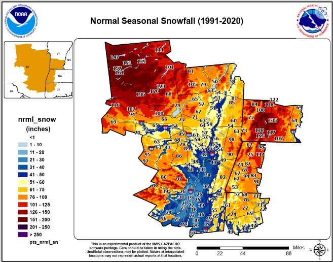
Poughkeepsie's average is around 36-38 I believe. Albany is generally around 50. I'm 10 miles north of Poughkeepsie and average about 40.
-
18 minutes ago, eduggs said:
That sucks. If I lived there those gorgeous snow maps would have suckered me in. There have been very few pure snow reports from east of the river this evening. CMC and to a lesser extent EC were on the right track here. I am slightly curious about the conditions above 1000ft in Putnam and eastern Dutchess.
It's disappointing for sure. I never thought we were going to get the GFS totals but I didn't think we were going to get nothing either. I was thinking 2 or 3 inches for a total. So far CMC/RGEM have been spot on. Maybe we get some light accums as storm pulls away later Friday/Friday night. Oh well, on to the next.
-
1
-
1
-
-
36 and moderate rain.
-
1
-
-
34 and doing absolutely nothing.

December 2022
in New York City Metro
Posted
The GFS evolution gives me over a foot so I'm rooting for it hard just like I am for Zach Wilson this Sunday although I think that neither is very good.