Beachin
-
Posts
337 -
Joined
-
Last visited
Content Type
Profiles
Blogs
Forums
American Weather
Media Demo
Store
Gallery
Everything posted by Beachin
-
Big improvements
-
Euro looks much better at 72
-
Fixed it
-
Euro at 48 higher heights and improved 500 not as strung out. Looks good really good so far
-
And the euro is running cheers to a good run
-
Not sure if it has been said yet but 12z icon is a pretty decent improvement
-
CMC pretty much is similar to the GFS but improved snowfall for everyone vs 0z
-
so close so so close
-
I actually don't mind this look to bad. Even though this is the NAM at 84
-
Woah 3k is way more amped then 12z and 6z runs. For those on the northern fringe I'd feel good with what you see right now.
-
00z should be really fun tonight
-
Gotta like what you see. Amplifying run after run.
-
Se Ridge is stronger to along with a deeper ridge in the west. 500mb looks great definitely gonna be north and probably stronger
-
Heights are higher so far on the NAM should be coming north again through 12. At 15 nice weaknes forming and confluence is breaking down sooner again. High is another MB lower then 12z and the Hudson bay storm is faster and deeper Should be a good result
-
Sref plumes went up pretty big time. Don't think this north move is finished. Mean is about 2 with several higher members
-
3 runs in a row of a weaker high and faster progression with the low. Nothing to stop this from going north at this point based on trends
-
Euro seems to be following the north trend. Out to 24
-
This will make alot happy. 12z JMA
-
Southern MD / Lower Eastern Shore weather discussion
Beachin replied to PrinceFrederickWx's topic in Mid Atlantic
Salisbury becoming white already http://www.salisbury.edu/webcam/hh/ -
Southern MD / Lower Eastern Shore weather discussion
Beachin replied to PrinceFrederickWx's topic in Mid Atlantic
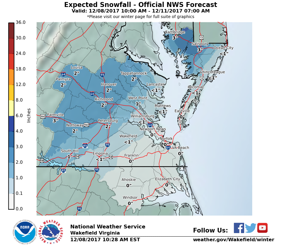
Winter Storm Warning URGENT - WINTER WEATHER MESSAGE National Weather Service Wakefield VA 309 PM EST Fri Dec 8 2017 MDZ021>023-090415- /O.UPG.KAKQ.WW.Y.0004.171209T0000Z-171210T0000Z/ /O.NEW.KAKQ.WS.W.0001.171209T0000Z-171210T0000Z/ Dorchester-Wicomico-Somerset- Including the cities of Cambridge, Salisbury, Crisfield, and Princess Anne 309 PM EST Fri Dec 8 2017 ...WINTER STORM WARNING IN EFFECT FROM 7 PM THIS EVENING TO 7 PM EST SATURDAY... * WHAT...Expect a mix of rain and snow to change to all snow this evening. Rain may briefly mix back in late tonight. Moderate to heavy wet snow expected. Plan on slippery travel conditions. Total wet snow accumulations of 4 to 6 inches are expected tonight into Saturday. Locally higher amounts are possible. * WHERE...Dorchester, Wicomico and Somerset Counties. * WHEN...From 7 PM this evening to 7 PM EST Saturday. * ADDITIONAL DETAILS...Be prepared for significant reductions in visibility at times. PRECAUTIONARY/PREPAREDNESS ACTIONS... A Winter Storm Warning for wet snow means severe winter weather conditions are expected. If you must travel, keep an extra flashlight, food and water in your vehicle in case of an emergency. The latest road conditions for the state you are calling from can be obtained by calling 5 1 1. -
Southern MD / Lower Eastern Shore weather discussion
Beachin replied to PrinceFrederickWx's topic in Mid Atlantic
18Z HRRR 10:1 but you get the idea no worries about stickage tho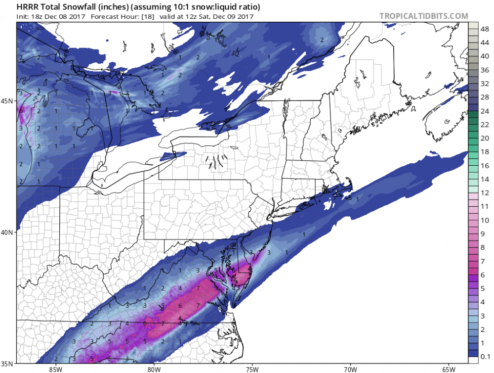
-
Southern MD / Lower Eastern Shore weather discussion
Beachin replied to PrinceFrederickWx's topic in Mid Atlantic
Kuchera and remember snow is sticking in the south with temps near 80 a few days ago. really don't see it being a issue especially near Salisbury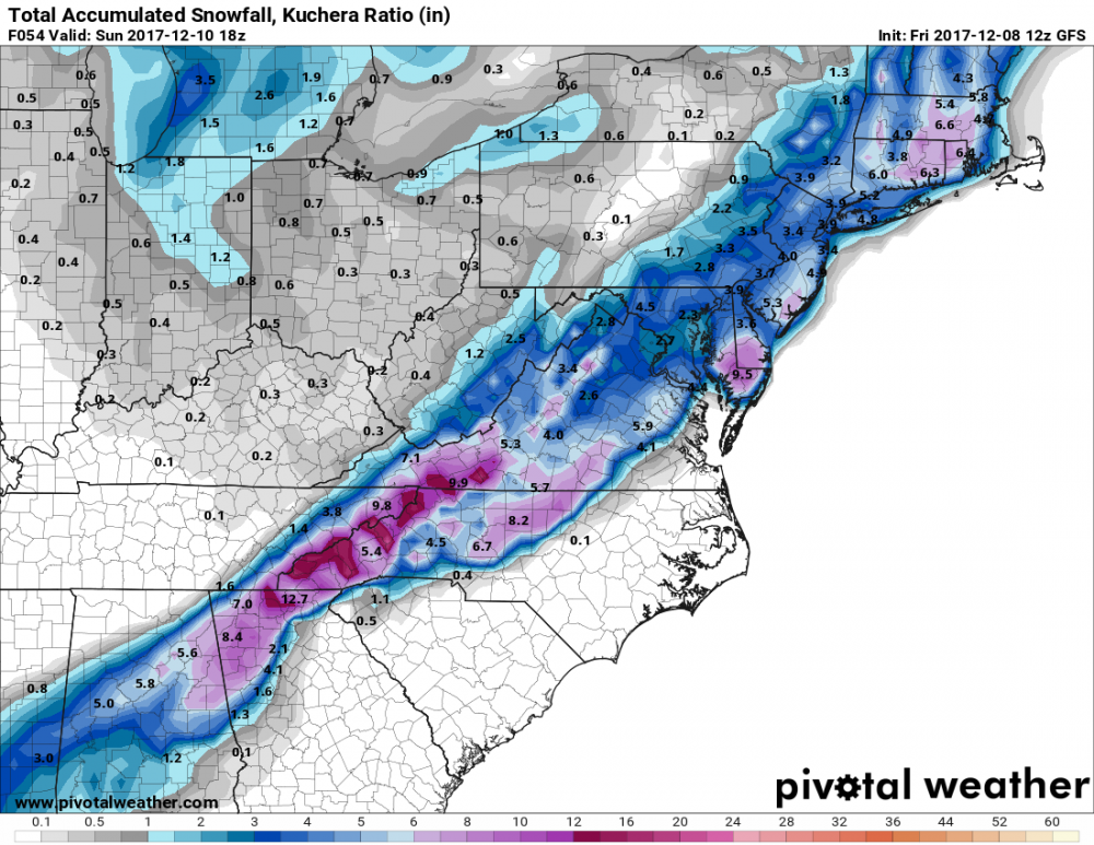
-
Southern MD / Lower Eastern Shore weather discussion
Beachin replied to PrinceFrederickWx's topic in Mid Atlantic
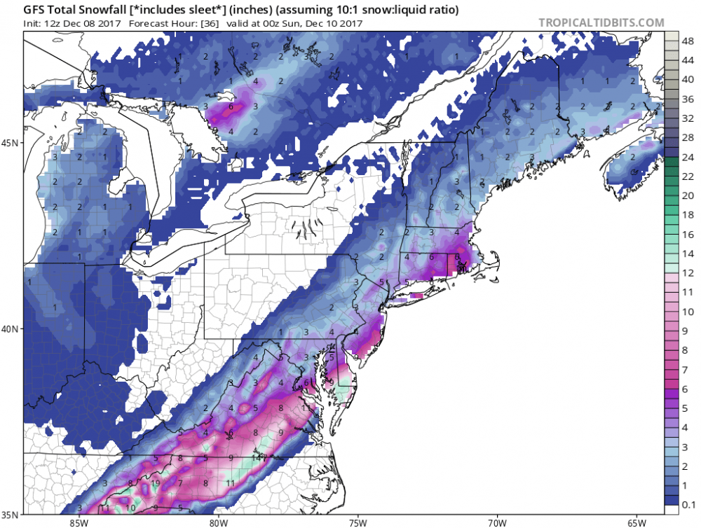
AKQ is slowly pulling the trigger this was pre GFS so i expect some big changes come afternoon don't be surprised to see WSW up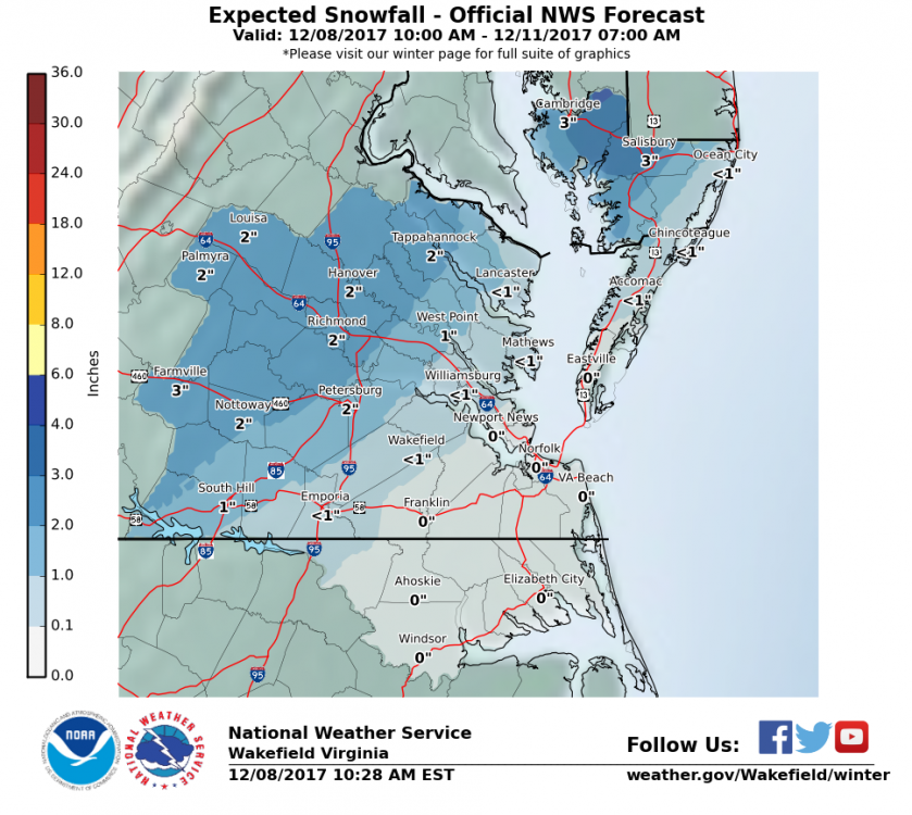
-
Southern MD / Lower Eastern Shore weather discussion
Beachin replied to PrinceFrederickWx's topic in Mid Atlantic
Probably not going to happen but the shore will do well with this