

BTRWx's Thanks Giving
-
Posts
3,332 -
Joined
-
Last visited
Content Type
Profiles
Blogs
Forums
American Weather
Media Demo
Store
Gallery
Everything posted by BTRWx's Thanks Giving
-

January 12-13th Cold Smoke Obs and Nowcast
BTRWx's Thanks Giving replied to Bob Chill's topic in Mid Atlantic
Use Dupage -
January 12-13th Cold Smoke Obs and Nowcast
BTRWx's Thanks Giving replied to Bob Chill's topic in Mid Atlantic
It's worth it. I was in your position once. -
January 12-13th Cold Smoke Obs and Nowcast
BTRWx's Thanks Giving replied to Bob Chill's topic in Mid Atlantic
Funny how there's a southern and northern border of the same city/county. -
January 12-13th Cold Smoke Obs and Nowcast
BTRWx's Thanks Giving replied to Bob Chill's topic in Mid Atlantic
2" -
January 12-13th Cold Smoke Obs and Nowcast
BTRWx's Thanks Giving replied to Bob Chill's topic in Mid Atlantic
HRRR snow depths only shows 4-5" max fwiw. -
January 12-13th Cold Smoke Obs and Nowcast
BTRWx's Thanks Giving replied to Bob Chill's topic in Mid Atlantic
You're both technically right. lol -
January 12-13th Cold Smoke Obs and Nowcast
BTRWx's Thanks Giving replied to Bob Chill's topic in Mid Atlantic
First flakes -
January 12-13th Cold Smoke Obs and Nowcast
BTRWx's Thanks Giving replied to Bob Chill's topic in Mid Atlantic
mping that shit -
January 12-13th Cold Smoke Obs and Nowcast
BTRWx's Thanks Giving replied to Bob Chill's topic in Mid Atlantic
Shout out to the reference to January 2010 yesterday! -
January 12-13th Cold Smoke Obs and Nowcast
BTRWx's Thanks Giving replied to Bob Chill's topic in Mid Atlantic
Someone please turn storm mode back on. -
January 12-13th Cold Smoke Obs and Nowcast
BTRWx's Thanks Giving replied to Bob Chill's topic in Mid Atlantic
Also notice the "assuming 10:1". Very nice! -
January 12-13th Cold Smoke Obs and Nowcast
BTRWx's Thanks Giving replied to Bob Chill's topic in Mid Atlantic
I guess this thread is technically not in storm mode yet, so I think they'll need to keep it for themselves up there. -
January 12-13th Cold Smoke Obs and Nowcast
BTRWx's Thanks Giving replied to Bob Chill's topic in Mid Atlantic
hr 18 shows mixing fwinw -
January 12-13th Cold Smoke Obs and Nowcast
BTRWx's Thanks Giving replied to Bob Chill's topic in Mid Atlantic
The max potential map keeps going up. -
Strong nino
-
There's something about February ending winter nina droughts and other variables I haven't looked into yet.
-
bump
-
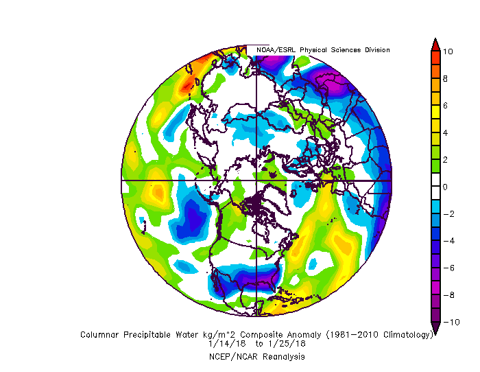
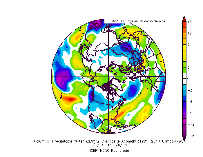
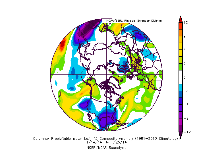
Fwiw, 2014 ended its drought big time the first week of February.
-
2011 was no dud, but I see why you mentioned that. No other 3 year span comes close to those though. eta: 1949-1953 may have been bad even with the low double digits overall, but the law of averages resulting from 2012-2013 ended in our favor.
-
I don't think dca has ever had 3 extreme dud winters in a row (though this year isn't done yet).
-
Maybe the dynamics will reach the arctic faster to save us.
-
Seed the valleys
-
The law of averages will win out eventually. We just might have to wait until spring.
-
It's good enough. I'm a little behind the times.
-
1996 was an anomaly. Who can decipher?

