

Thinksnow18
-
Posts
4,144 -
Joined
-
Last visited
Content Type
Profiles
Blogs
Forums
American Weather
Media Demo
Store
Gallery
Posts posted by Thinksnow18
-
-
You know I think it was BW that said how our local Mets weren't that good anymore...well I have to agree even more. I just watched WIVB 4 in buffalo and for next tues-Wed he has 37 and 40 degrees...i have looked at 1 model that shows temps that warm during that timeframe next week...oh and FWIW the 6z GFS has WNY and CNY getting pounded by next Tuesdays storm.
-
 1
1
-
-
Love this for next week's storm:
-
NWS has jumped on the LES train for the metro!!! They do say only 1 to 2 inches north of buffalo but the key is that the meso models are also agreeing on thus shift...starting to get excited
-
1 hour ago, WesterlyWx said:
Short range meso models really getting that band close to the city...

It appears to me by blowing up the pic that it's right over downtown...which inevitably means 5 or so miles north...
-
1
-
-
I'm shooting further...the lake event last December went 10 to 15 miles further north due to the warm lake waters and this is early November...im seeing a wide area of 2-4" from amherst to south buffalo where gradually we'll see 3 to 6 and then 4 to 8 as we get to hamburg o.o area.
-
1
-
-
The models ALWAYS undersell the warmer lakes and how the bend to the band can send lake snows further north than modeled...happens every year and every year it is forgotten about!!!
-
Ok fellow weenies...i know we've had our fair share of LES events in November but when is the last significant synoptic storm we've had in November??? I'm struggling to remember one!!!
-
40 minutes ago, wolfie09 said:
Valid to sat morning

Those totals seem way different than the other 2 models...well guess it's an early battle for model supremacy!!!
-
 1
1
-
-
8 minutes ago, SouthBuffaloSteve said:
That’s a transition zone special! Should be waking up to a winter wonderland Saturday morning! Hype level is a solid 9 out of 10 right now!
The heart of that band is Amherst to south buffalo with the Lackawanna south buffalo are with the bullseye...if this is realized 6 to 12 is likely with local amounts if up to 2 feet
-
1
-
-
23 minutes ago, WesterlyWx said:
I know it's pretty hard to see and pretty coarse but the BTV WRF has a bullseye over the southtowns of over 1.5" liquid equivalent and that's not even the whole thing as the band is still over the southtowns at the end of the run. This is likely way overdone but the potential for an accumulating (possibly significant) snow event for the southtowns is looking like more of a possibility.

I think what is important here is both models are getting into their sweet spot of forecasting...this shows up tomorrow and the snowblower will need to be run.
-
28 minutes ago, BuffaloWeather said:
It doesn't last long, winds quickly go NW.
No matter!!! This is all gravy anyways!!! To be 3 weeks from met winter and 6 weeks from the winter solstice I'll take it!!! No one expects it to last but just the thrill being back is cool enough!
-
3 minutes ago, BuffaloWeather said:

Stop it or I won't be able to sleep...for the next 3 nights!!!
-
1
-
-
40 minutes ago, wolfie09 said:

Starting to think Tuesday night Wednesday will give the entire CWA the first accumulating snowfall of the young season. Looks to be a hybrid of Lake enhanced and synoptic transitioning to lake effect Wednesday night in the traditional snowbelts downwind of the lakes.
-
1
-
-
I try not to put much stock in the weather channel at all, let alone their 15 day outlook, but they do have Williamsville next week at 32 for a high next Wednesday and after this Friday not getting out of the 30's for daytime highs for 8 days...looking at all the data I think this is a bona fide chance we will all see our first accumulating snows as an area regardless of elevation by next week. Might be a coating or an inch but this pattern has that chance.
-
Still a nice appetizer for us snowlovers!!!
-
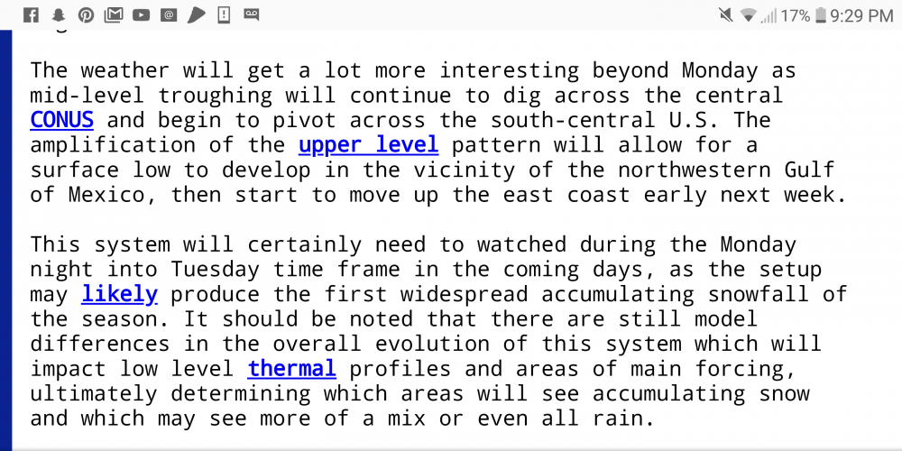
Something is definitely brewing 6 days from now. The morning runs of the GFS show a pretty decent early season snowstorm with a Miller b type scenario and transfer to the coast leaving the whole CWA cold and snowy. This is shaping up to be one interesting week of tracking.
-
2
-
-
That's all 3 models showing this pattern. Starting to look like at minimum we will see low to mid 30's for highs aven at lower elevations next weekend.
-
1
-
-
3 minutes ago, BuffaloWeather said:
I saw this on Facebook, incredible stuff.
-
3
-
-
27 minutes ago, ayuud11 said:

I mean what do we even do with that??? That would only be 3 days before snowvember 14 so that is a legit threat/possibility. I'm going to need a bigger hot dog bun...
-
1
-
-
One thing is certain we will see our first 30 degree temps area wide next weekend and into early next week. This has the making of a possible event IF the right LP comes into play during that timeframe.
-
1
-
-
Just looking at GFS 6z from hour 216 to 240 would be a pretty long lasting event and temps not warming up for a couple days after...
-
1
-
-
4 hours ago, vortmax said:
Are they picking up on a SSW event? Anyone have the wind chart for that? Usually a 6 week lag, I believe.
I can't find one, maybe BW can get one? The SSW that appears on the CFS does have support in the ECMWF for the end of November. The question is does it propagate enough to get that low to elongate more towards N.A. and drive our first cold blast.
-
4 minutes ago, BuffaloWeather said:
We put an offer in on a house today and it got approved! Sticking in Hamburg for a little longer.

Congrats!!!
-
 1
1
-
-
WIVB in buffalo put out their winter outlook and of the 4 Mets 2 said normal snowfall 2 below, the same 2 said average temps that said normal snowfall and the 2 that said below normal snowfall said above normal temps...not really sure what signals they're seeing that gives them those predictions...although they are just that after all.


Upstate/Eastern New York
in Upstate New York/Pennsylvania
Posted
Moderate snow transit and wehrle...sticking to everything but roads.