

Thinksnow18
-
Posts
4,144 -
Joined
-
Last visited
Content Type
Profiles
Blogs
Forums
American Weather
Media Demo
Store
Gallery
Posts posted by Thinksnow18
-
-
Gotta say I'm a bit surprised about something mike cjaika on WIVB on this weekend's noreaster says the reason we aren't looking at an early season snow storm is there is not enough cold air in Canada to pull down...hasnt Canada been very cold this fall with AN snowfall? Where is all the cold air?
-
For the first time this year Williamsville has hit the freezing mark. Nice coat of frost on car windshield. Now if the grass would just stop growing...
-
That's as strong a signal you can have for east coast cyclogenisis. Now let's watch this weekend unfold.
-
2 hours ago, BuffaloWeather said:
The next month continues to look below normal. Maybe that 76-77 analog is on to something.


Again alot of great indicators pointing to really good possibilities of BN temps in the east. IF this 3 to 4 week outlook verifies there's no doubt in my mind that someone in our CWA will see the first significant LES event.
-
 1
1
-
-
1 hour ago, wolfie09 said:
First eye candy of the season, enjoy it, will be gone soon lol


Funny thing is while it probably is a unicorn run, the prevailing theme during that timeframe has been to bring in th southern jet with a LP system somewhere in the northeast that drags down the coldest air of the season...if it's not the scenario shown it could very well be the first LES event in the first part of November.
-
2
-
-
1 hour ago, BuffaloWeather said:
Long range GFS but has Euro and Ensemble support of it getting pretty cold in early November. We will see if it keeps getting pushed back like the last several years. But if it came to fruition, first lake effect snow event is close.
Well to that regard the GFS and other output models sniffed this pattern change we are in now a good 240 hours on advance so I'm buying this year so far...
-
1 hour ago, WesterlyWx said:
Only a couple scattered flakes/pellets here as this area is about the worst area in WNY for a NW flow. Still was nice to see any kind of frozen precip so not trying to complain. Mother in law up in Amherst had a full dusting of snow/graupel even on the roads last night.
Yes we did...in fact im kinda questioning the temps here...went to the store this morning at 5:15 and when I turned on the windshield wipers to wick away what I thought was just slush was frozen solid to the windshield. The hood was the same way and looking on the hot tub cover as the sun is poking through I can see the water and pellets are frozen to that as well...i didn't think that could happen at 35...
-
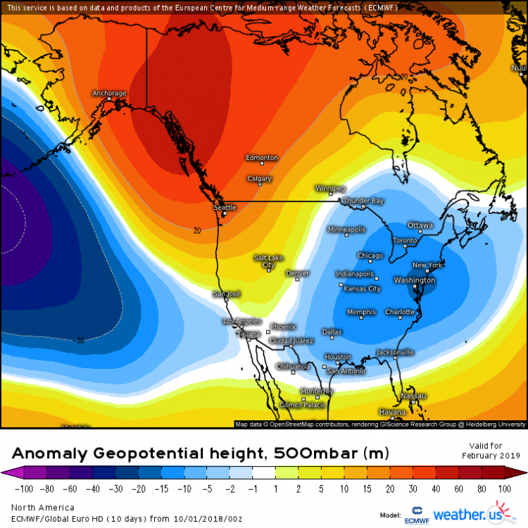
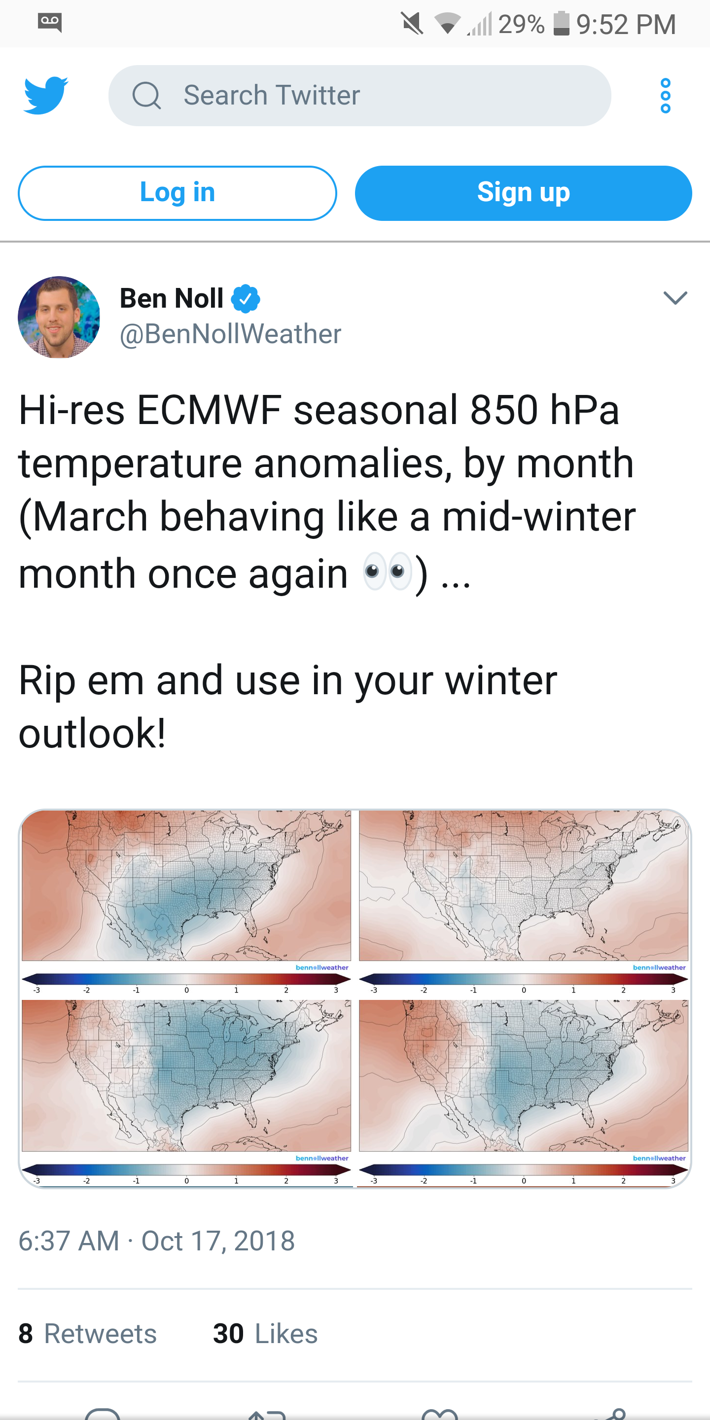
Just another look at the euro monthly output.
-
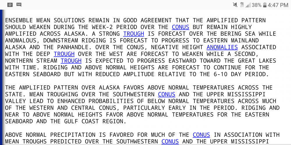
I know, it so far into fantasyland Disney wants to trademark it, but the hours between 300 and 364 on the GFS all day have been hinting at a deep storm that brings on the coldest air of the young season by Halloween. Why I think this is something to watch is at the very same timeframe the NAO goes negative and PNA positive as BuffaloWeather pointed out earlier. The 18z does show a cold blast where the 540 line reaches well into the south near Georgia and a decent snowfall behind a wrapped up low that gets hung up in eastern Canada. The model run itself is speculative at best but I believe it's the premise of what is trying to be shown that matters.
-
1
-
-
4 minutes ago, BuffaloWeather said:
How excited is too excited???
-
Could this be the first month since April that we finish below average in the mean? Yes there were quite a few warm to even hot days the first week of the month with temperatures some 20+ degrees above normal in some of those days, however , if days like Wednesday and a good chunk of next week beginning Sunday materialize we could be looking at temps some 20 degrees below normal...will be close for the month.
-
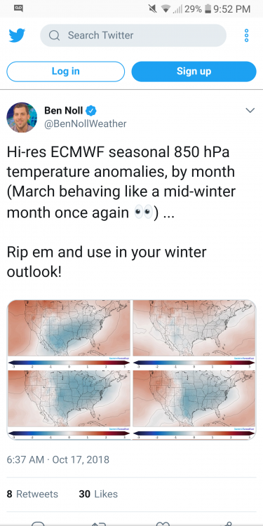
1 hour ago, BuffaloWeather said:
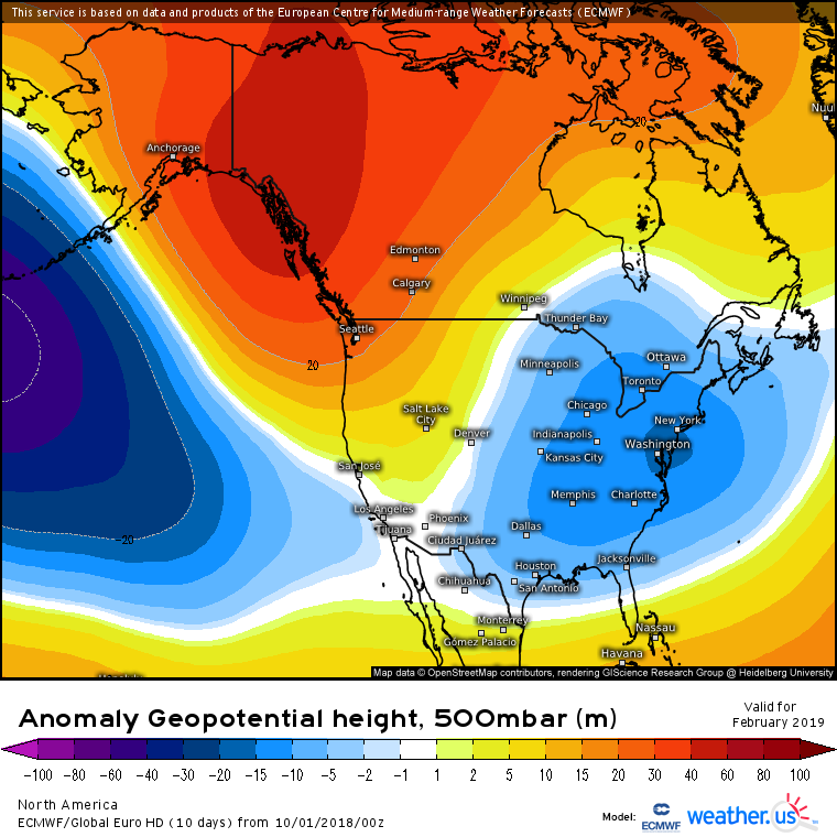
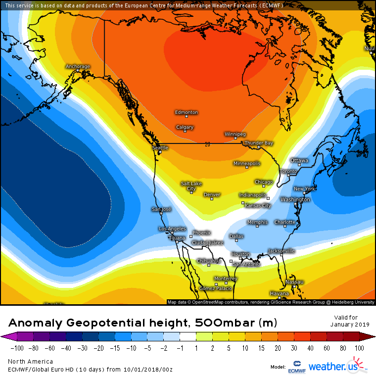
New Euro seasonal is out.


Saw that in the New England forum the other day...there are alot of very excited weenies right now and im not just on board the hype train in driving the damn thing!!!
-
 1
1
-
-
So it appears that next weekend, mainly Sunday to Monday looks quite possibly to see accumulating snowfall from lake effect downwind from Erie and Ontario. The last 4 runs of the GFS including 6z this morning show -6 to -10 850mb air which would correlate to temps in the 30's at lower elevations during the daylight hours and temps flirting with freezing or below in the highest elevations.
-
I'm starting to think we might be seeing the beginning of some pattern recognition...while it would be foolish to think we will just stay western Ridge eastern trough for the next 5 month's, there are quite a few signals pointing to this being the mean pattern for winter. Eastern QBO, modoki El Nino, SAI advance in N. America and solar mins...at the very least im liking what im seeing.
-
2
-
-
2 hours ago, CNY-LES FREAK said:
Michael is going to completely obliterate that disgusting monster of a Bermuda High that's been ever present it seems like.
Sent from my SM-G930V using Tapatalk
That was my exact statement a few days ago!!! This storm will give us the break we needed to get our weather back to more normal conditions.
-
7 minutes ago, CNY-LES FREAK said:
I feel real sorry for people along the northern coast of Florida along the Panhandle. Apalachicola is getting pummeled right now. Wherever that eastern eyeball passes over there's going to be catastrophic damage and I seriously think the back areas of the Gulf are going to be rearranged forever. It should hit as a Cat 4 but the latest adv has the pressure down to 929 which is the lowest recorded pressure ever within a Tropical System. It could reach a low Cat 5 with ease as well with waters off the immediate coast up near the upper 80's. I hope ppl took heed to the warnings and evacuations that were issued because if they stayed, forget about it.
Sent from my SM-G930V using Tapatalk
Good point...this is starting to take an Andrew type look to it...rapid intensification just off shore...will be devastating for certain.
-
So I still can't download pics or snapshots but I implore you all to check out the GFS 00z model on tropical tidbits...it would have a full blown LES downwind of the lakes bullseye over tug and southern tier...and just for giggles 6z in same time frame shows the same...hour 196 to 224
-
7 hours ago, BuffaloWeather said:
https://www.wunderground.com/history/monthly/us/ny/buffalo/KBUF/date/1976-10
Around mid month it got colder and stayed cold and snowy the entire winter. It's a very rare analog.
Super interesting link to that season. I looked at the data for October and it appears it will line up with the way this month is forecast to play out. It started very warm that year for the first week then we fell off a cliff but averaged 40's and 50's the rest of the month. Looking at the next 15 days which takes us into the last week of October we will average the 40's and 50's the rest of the month. I am super interested to see how this plays out.
-
BuffaloWeather...you have said on numerous occasions that the one winter season that you keep coming back to in the analogs is 76-77. If im not mistaken didn't that year start cold in mid October and just go full force winter right through mid February? I'm not suggesting that is what is going to happen here as that is a once in a lifetime winter, but, I do wonder if we may get into a pattern evolution that may take the form of what our winter on a whole will look like...your thoughts?
-
I know it's in fantasy land but the GFS is really showing true cold air at the end of the 00z run that would leave no doubt about what form precip would be in. And that's after the chilly air this weekend into early next week...i think this hurricane has really done all of us a solid and pushed the Bermuda high back where it belongs.
-
1
-
-
Im kinda shocked this thread isn't at least discussing the prospects for the first flakes this weekend over the tug and interior western southern tier. And Monday-Wednesday timeframe looks to bring an actual cold airmass with 40's for highs if the GFS has been correct the past 8 runs or so.
-
Almost reminds me of the flooding that hit Gowanda about 7 or 8 years ago after storms trained that area to the tune of about 7"
-
For some reason I can't load the snapshot but the 12z GFS at hour 240 to 264 looked mighty nice for first true cold air, transient, but cold.
-
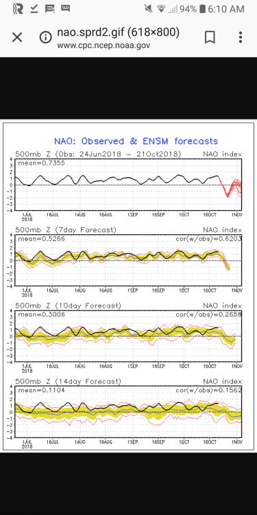
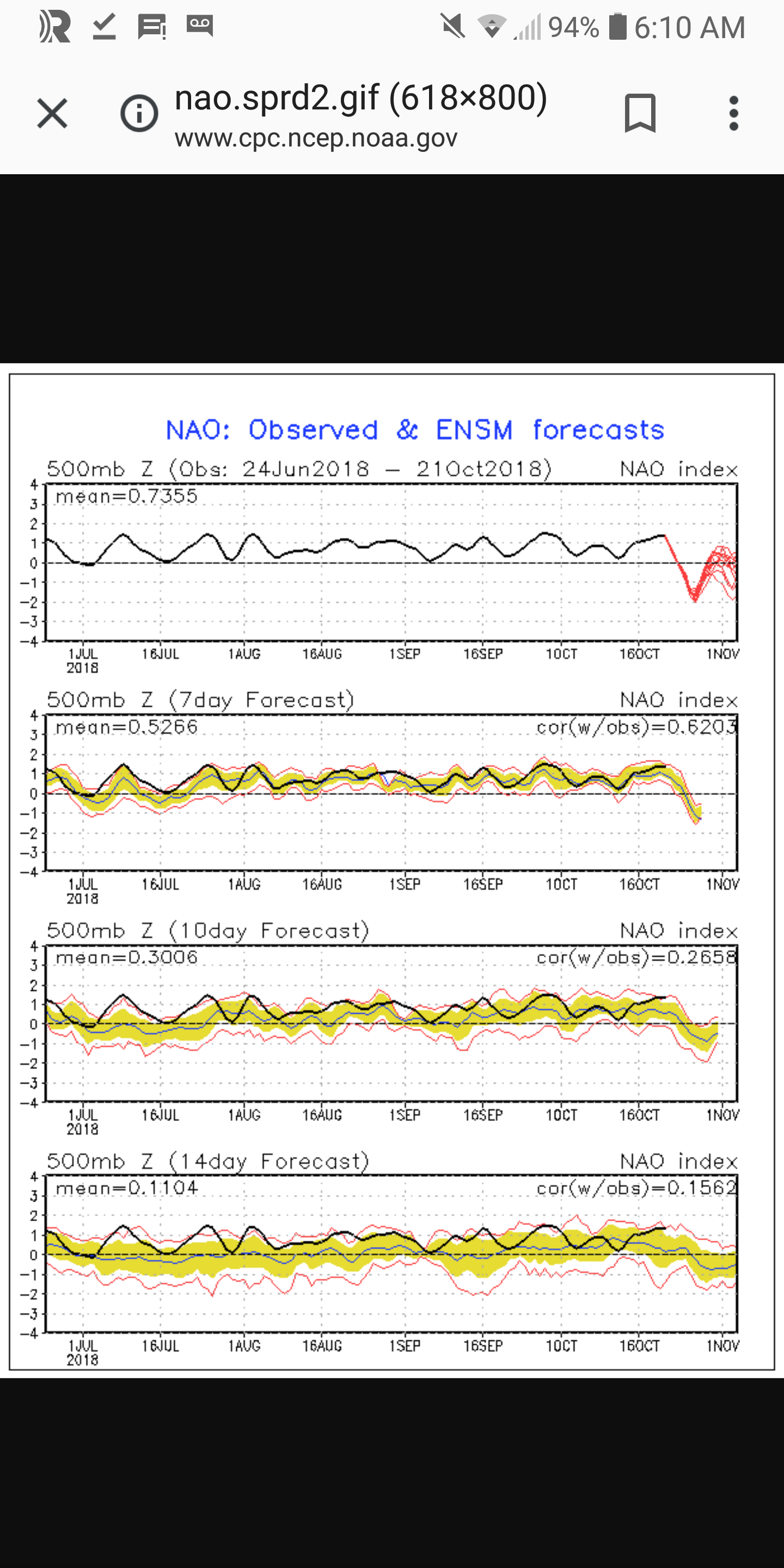
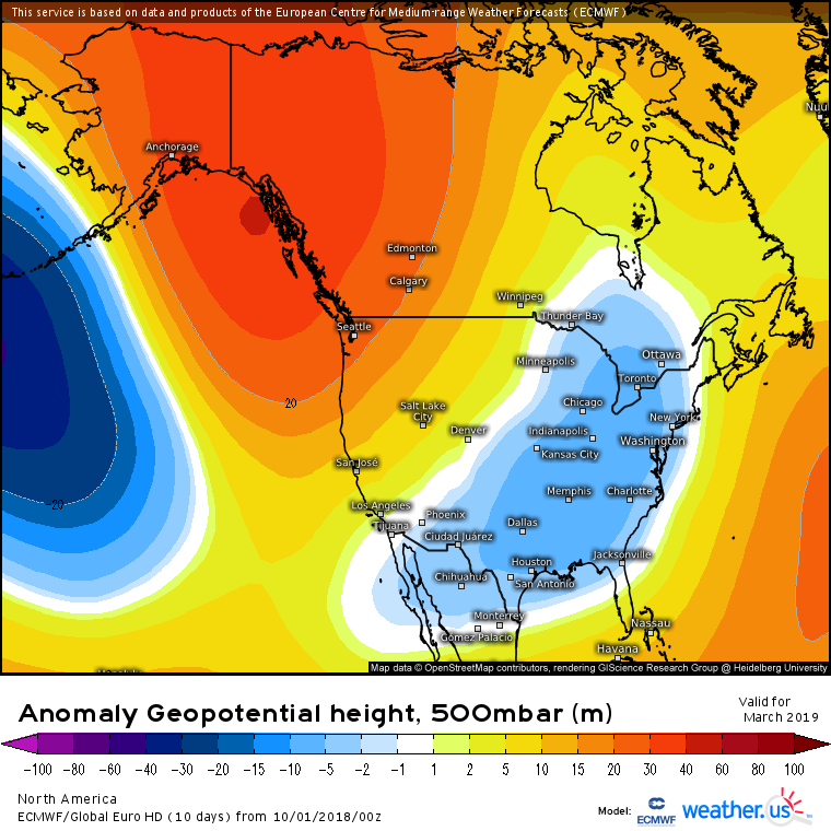
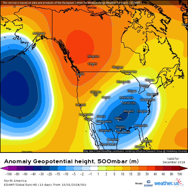
CPC in their prognostic discussion during the 8-14 period starts to discuss the cooler air moving into the GL with time.

Upstate/Eastern New York
in Upstate New York/Pennsylvania
Posted
So I have to say this above and what the ECMWF have been forecasting since about mid October is really starting to make me wonder what the CPC is looking looking at with the next month and also for the winter as a whole. Checking out the first 10 days of November does not seem torch worthy and by mid month there appear many chances for cold air intrusions and the storm track pushing a bit further south out of Canada. To me the CPC is lazily forecasting on the basis of El Nino alone and not the stength of it, position of the warmer Pacific waters off the West coast, upper level trends already, etc...