SRRTA22
-
Posts
1,872 -
Joined
-
Last visited
Content Type
Profiles
Blogs
Forums
American Weather
Media Demo
Store
Gallery
Everything posted by SRRTA22
-
Right? It is what it is though. Happy for them. We cash in on severe this summer while they bdcf
-
Dude Hank is awesome! That is one of the craziest, if not the craziest video Ive ever seen from him and he has ALOT of crazy videos haha. Dude is a legend.
-
I got rain with occasional sleet mixed in
-
There might have been triplets. There was anticyclonic rotation as well
-
Hey atleast its not warm and nice out! Makes it feel better staying indoors
-
Its april 21, nyc metro had a tor warning and isolated wind damage across the area. What more do you guys want? Sheesh Gusted to 43 with the squall. Current temp now is 54f @NJwx85 A+ for the Hurrrrrr
-
Great storm. Great job by the HRRR as well.
-
200-400 j/kg of surface based cape will be more then sufficient. Elevated cape will be there as well. With the strong winds aloft this can definitely produce some nice winds in areas.
-
Def some weak spin up potential tomorrow with the low cape/high shear along the QLCS. Gonna be interesting to watch
-
Got too used to the craziness we've witnessed the last decade. Im okay with it. The frequency of how many big winter storms we've had actually took away from the wow factor. We need this break man. We may not have had a KU the last two years, but we've had some crazy intense snow squalls. We take what we get man. I , myself found that snow squall more interesting then a big blizzard. The rarity of events like that is what makes them so special.
-
I could tell someone got a good snow shower west of me. Obviously it wasn't going to be crazy here in metro nj, but you can tell that it was ripping nicely about 500 or so feet up. Couldn't believe the flurries made its way to the ground at 45 degrees..even if it was for a few seconds, lol
-
Color me surprised! We had about a 5 second burst of flurries here in Jersey City,NJ! You can actually see curtains of snow high in the clouds if you got a good vantage point. Awesomeness.
-
Nice grab dude!
-
Nice little sup in Hines,Fl , showing signs of rotation. Wont be nothing to crazy but could see a weak f0 around that area. Seeing a sketchy CC drop that aligns with the rotation but could be from the inflow. See what the next scans show (Dont bash me for being from NJ tracking some cells in florida, lol) *edit* Wouldnt be surprised if there was a weak TOG near Hines,FL
-
All that tracking the svr in dixie to SC yesterday into this am has got me in severe mode. Little bit bummed that storms were meh up this way but it is what it is. Not enough time in the warm sector. Makes you wonder what would've popped off if we had a nice warm sector.
-
That cell north of Philly will be the one to watch
-
Slight Risk expanded slightly to include NYC Probs: 5% Tornado ; 15% Wind ; 0% Hail
-
Peak gust of 42mph here in Jersey City as of this moment. Some decent rotation on that cell just south of Dover,DE. And as @NJwx85 pointed out, gotta watch those cells ahead of the line in SNJ
-
SC storm recycled and has another TDS on it, SE vicinity of Moncks Corner, headed NE towards Bethera and Jamestown
-
Rotation headed towards the northern end of Summerville. More towards Ridgeville. Debris sig has dissipated but the rotation is still pretty strong. Stay safe man
-
That is a mighty tornado in livingston,SC goodness...
-
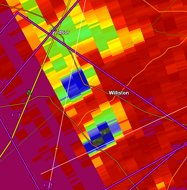
CC image from 5:40AM Williston,SC
-
TDS on it. We got twins boys
-
I went to the bathroom and the thing went bonkers..not even surprised. Crazy TDS now
-
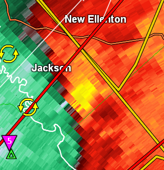
Intense rotation in and near Jackson,SC , no indication that its on the ground