

Wetbulbs88
-
Posts
1,386 -
Joined
-
Last visited
Content Type
Profiles
Blogs
Forums
American Weather
Media Demo
Store
Gallery
Posts posted by Wetbulbs88
-
-
This week has somewhat made up for the lull. Getting two to come back our way and then outperform considerably is a pretty good deal.
Easily 5” here in AdMo. Snow is really high in some places!
-
Wow this band means business!
-
Everyone should be happy here considering what was depicted two days ago.
im guessing about 3.5-4.5” here in AdMo. Light snow not doing much accumulation. But even if we don’t get under another band I’m happy as a clam with this one. The puppy is in heaven!
-
4 minutes ago, BryanInMd said:

It's actually not backbuilding as much as feeding from the other side of the Apps. Pretty sure that radar jump isn't real. Radar always has trouble picking up the higher elevations when there's strong orthographic lift.
-
Also, roads completely covered here in AdMo--EVEN CT!!!
-
This is even better than last storm, at least here in AdMo. Way better rates and dendrites. Our Bernese pup is absolutely thrilled. She's passed out now from our last romp.
Last storm was pretty cool, but this is the first true snower in years.
-
 2
2
-
-
29 minutes ago, AmericanWxFreak said:

The HRRR is hard to trust but I’d be happy with this result.
-
1
-
-
3 minutes ago, BristowWx said:
I feel like the only way they close is if it was a widespread WSW.
They closed for the last event. But that may have gone WSW during.
-
1 minute ago, DDweatherman said:
He’s right, we need new data to go with the new thread. 18z usually doesn’t turn us around if 12z sucked
Think this is a myth but I choose not to believe that either.
-
Just now, Heisy said:
Am I the only one who walks there cats in the snow? Lol I’ll take pictures later
.Holy crap please do.
-
1 hour ago, TinGTown said:
Still no flakes in Georgetown (DC) for several hours. It's now a misty rain. What are we to expect?
Huh? I’m in AdMo and there’s at least 2.5” on the ground with moderate snow.
-
5 minutes ago, stormtracker said:
FOLKS!
Can confirm. Columbia also covered.
-
7 minutes ago, TinGTown said:
I am not panicking...YET...but it has been snowing, in various forms from pixie dust to legit light snow here in Georgetown (DC) all day. Now there isn't a flake in the sky.
I thought the heavier amounts of snowfall should be happening now through the overnight hours. Am I in a temporary snow hole? Planes are taking off from DCA or maybe landing because I can hear them on my semi -Jeb walk with the dog. What should I expect?
I know its an IMBY post. Sorry!
I’m in Adams Morgan and there is plenty of snow. Probably 1 or 1.5”. The main event is just gearing up.
Look at the radar. Look at the models. You should see that things are just getting real.
-
1
-
-
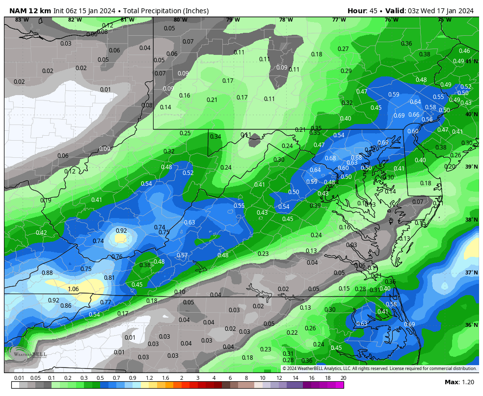
6 minutes ago, MillvilleWx said:
This is a reminder to pay zero attention to the HRRR for this storm unless it really gains a clue. It is off immensely at this point to where a certified meteorologist is not following it at all. It has been wrong the entire event so far. It had ZERO snow north of the Potomac for much of last night and didn’t have any until late runs as it was already happening. It has no snow in the area right now and we know for a fact it is dead wrong.
Don’t bother. NBM is also too low on snow right now and it is because of the HRRR factor into the forecast. NAM Nest is doing a formidable job at the moment. Obs show a nice start and the best ascent is still to our south. Good stuff not till later. Enjoy and just watch it fall. Models be damned.
I was just thinking that the NAM has had this cold. Many here continue to blast that model, when this is far from the first time that it's carried the day. Yes, it's streaky, but it's still often a better short-range model than the globals.
-
What's your go-to radar site? Nothing does the trick for me. Closest thing to acceptable is this cod map, but not enough perspective for my liking. NWS is just god-awful...
-
6 minutes ago, pazzo83 said:
for some reason they didn't treat many of the side streets in Tenley/AU park. A lot are snow covered. Wisconsin and Mass seem to still be clear.
It’s pretty random here too. I feel like they get lazy when there hasn’t been snow for a while, but maybe that’s in my head. But there’s way more salt on the sidewalks through Kalorama Park than the side streets near my building.
-
Wife and I and the new puppy just jebbed for some coffee. Absolutely gorgeous outside. It’s been way too long.
Our 9-week Bernese is utterly thriving in the weather of her people.
-
7
-
-
Just now, pazzo83 said:
Close to an inch here in NW DC, light snow all day. Just beautiful.
About the same here in AdMo. Starting to overcome the salt on the more heavily treated roads and walkways as well.
-
1
-
-
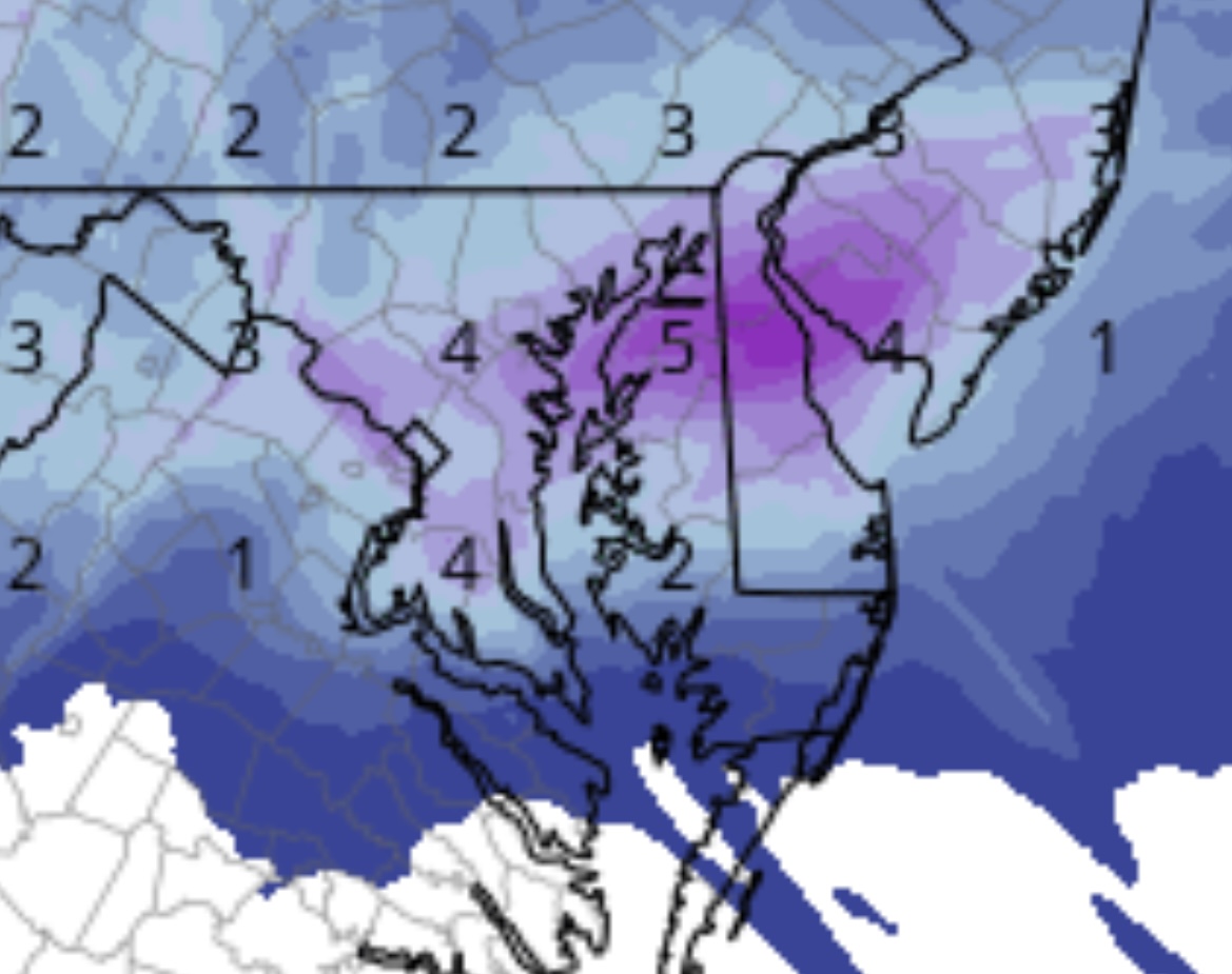
2 minutes ago, clskinsfan said:
18z HRRR

HRRR seems to have been too dry throughout. Did it have any of this pre-game stuff throughout the overnight and AM?
Really like where we sit right now.
-
Legit -SN here in Adams Morgan. Haven’t seen this in a long time.
-
3
-
-
39 minutes ago, stormy said:
The 12z NAM drops qp from D.C. sw the Staunton. Snowfall also drops accordingly an inch or two. Hopefully the 12z GFS does not follow .

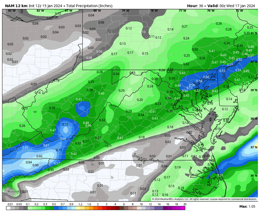
Probably just coming in line with the other competent models. I’ll take 0.5 any day.
-
1
-
-
25 minutes ago, Ralph Wiggum said:
January 25, 2000 vibes....well, maybe not that insane, but the trends continue
This is my favorite storm of all time. I saw the radar the night before. I was in sixth grade and remember thinking, “That looks like it’s headed right for us.” And yet Bob on NBC was saying we were just gonna get grazed for an inch or two.
-
3
-
-
9 minutes ago, Fozz said:
Did we just get NAM’d for an event 90% of us gave up on?
I live to get NAM’d.
-
6 minutes ago, weatherpruf said:
Why bother to troll on a weather forum? On a Friday night? I mean, I know there's a pandemic on and people are not going out much, but there's a lot of good tv streaming these days....
Troll? I’m not trolling. I’m looking at the radar and am not impressed.
-
 1
1
-

January Discobs 2024
in Mid Atlantic
Posted
Confused about the forecasting, especially with NWS in our area. The wife and I are headed to the Ravens game today and were expecting a soaker. But none of the mesos have any rain after this back edge pulls through—which it just did.
NWS has “rain before 10AM” today. Fair enough, these point and click forecasts are always whatever. But then it has “rain before 10PM” tonight.
The NAM suite shows absolutely nothing after this morning. The GFS shows some spotty rain but it’s well out of its range.
Hoping we can just wear our Ravens gear and avoid busting out the ponchos. Fingers crossed.