

Wetbulbs88
-
Posts
1,335 -
Joined
-
Last visited
Content Type
Profiles
Blogs
Forums
American Weather
Media Demo
Store
Gallery
Posts posted by Wetbulbs88
-
-
11 minutes ago, Jt17 said:
you in Maryland? lol
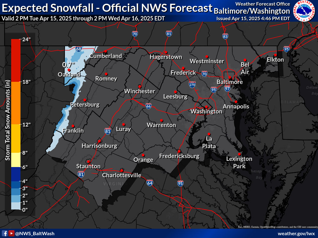
I am but I’m from Harlem. Just looking at radar, looks like 2-4”
-
This thing does not look west enough at all.
-
22 minutes ago, Maestrobjwa said:
I beg to differ...got any records? Our biggest storms have been As not Bs!
19 minutes ago, Ji said:23 minutes ago, Maestrobjwa said:I beg to differ...got any records? Our biggest storms have been As not Bs!You need extreme blocking like feb 2010 and even that was a close call. The 2nd blizzard not the first
19 minutes ago, notvirga! said:A couple example for dc/ Baltimore would be feb 78 and the second storm in feb 2010.
18 minutes ago, The Ole Bucket said:The infamous Snowquester was a Miller B and while you all and DC got the shaft... Charlottesville was smashed with extremely heavy, wet snow. 16 inches here.
And I rest my case.
-
 1
1
-
-
7 minutes ago, Maestrobjwa said:
Color me skeptical...that kind of thing almost never seems to pan out (except maybe a flurry or two). Of course I could've be biased...as I'm stickin' with the prediction that we either get 1-2' or nothing at all, lol
Miller B's have panned out for us. They tend not to, but some of our biggest storms have been Miller B's.
-
I also just tuned in. To me it whiffs the entire DC Baltimore area. Any different than earlier runs?
-
 1
1
-
-
6 hours ago, WxUSAF said:
It’s essentially showing how similarly the various hydrometeors (precipitation) are reflecting radar energy back to the radar. When it’s a uniform red color, they all are quite similar. Right now, that means all snow. Later, you’ll see a bright yellow and green line cutting through. That’s where there’s a lot of mixing and different types of precipitation droplets/particles.
Looks like that line is busting through right now.
-
SN+ breaking 2" easily. Absolute bust high on this one. Should have stuck with the WSW.
-
4 minutes ago, Always in Zugzwang said:

Where are you at? I'm in Martin's Additions--except now I'm in Adam's Morgan at my fiancé's.
-
9 minutes ago, jayyy said:
18F / 5 @ mi casa
Models are definitely busting high on surface temps at this juncture, but unless the h5 and surface lows magically shift hundreds of miles east, the general area will meet the same fate as we’ve been expecting for a few days now.
Guess there’s a shot at a few extra hours of wintry weather, but we’ve seen this setup before (low driving over or west of us) — we always comment on temps being lower than expected leading up to it, and the mid levels get torched all the same.
If my house gets 3-4” of snow into a sleet fest and/or dryslot, I’d consider that a win in this setup.He is absolutely wishcasting
I don't think so. He just said more snow. He didn't say all snow or a historic storm.
-
11 minutes ago, Baltimorewx said:
Could anyone post the link to the co-efficient radar? Obviously going to be important to follow today
8 minutes ago, WxUSAF said:What exactly is this map? Does it show where the sleet line is and therefore snow/ice/rain gradients?
-
7 minutes ago, Warm Nose said:
Surprised LWX is sticking with these totals. Wonder though if they may come off these in the morning.
They don’t run away from one NAM run. They run toward the NAM and face it down.
-
1
-
 1
1
-
-
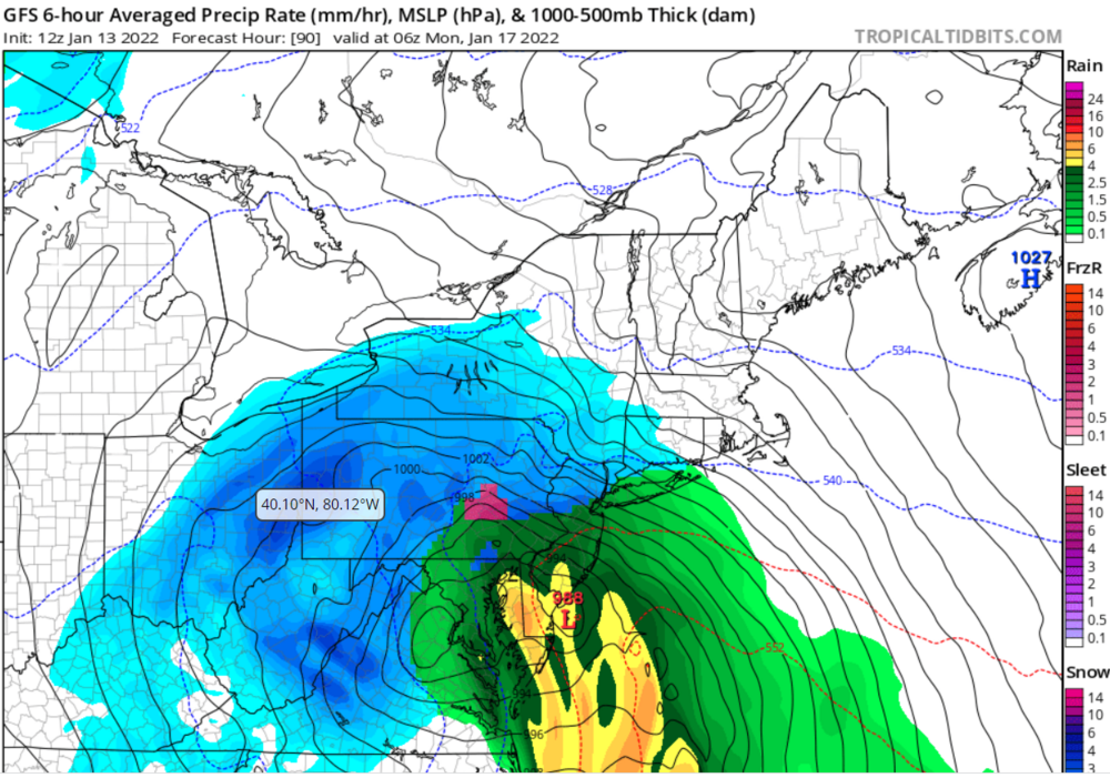
Am I crazy or does the GFS have the primary Low in a totally different spot?
-
48 minutes ago, gymengineer said:
Oh, his Annapolis tornado antics is just one example. And his response to other meteorologists’ criticism of him for that reinforced a pattern.
Can you give more detail or a source?
-
24 minutes ago, gymengineer said:
He’s certainly ruffled a lot of feathers lately for a bunch of other reasons.
Like what?
-
1
-
-
It seems like TT is showing different things on different devices. My Monday 06z frame looks nothing like anything anyone posted here...
-
If you’ve been doing this longer than a couple years you should know we are not even close to a solution right now. The models are chasing lows all over the place as it phases over the Carolinas. How often do we see a low in SE Virginia end up in Harrisburg? Can it happen? Absolutely. Do I have any confidence in these models right now? Absolutely not.
Stop. Taking. Runs. Verbatim. They are literally cartoon depictions. The GEFS shows you firsthand how f*ked the models are right now. Plenty of time to go. The trend tonight was clearrrly SE, until, somehow, we get a 980 low in western PA. I have a feeling it’s not hurricane season anymore. Let’s see what details the Euro gives us.
-
2
-
 1
1
-
-
20 minutes ago, WinterWxLuvr said:
Holy shit thanks for that.
Absolutely love this site.
-
1
-
-
I was gone for almost a day. Seems like the ledge jumping finally stopped.
-
21 minutes ago, Fozz said:
I can't blame you. I think most of us consider a HECS to be anything over 20", but to get twice as much is just ungodly. Not many people outside a mountain or LES snow belt will ever see a 40" storm in their backyard.
I got 34 inches from snowmaggedon. I’ll never see that again I don’t think. And I DEFINITELY won’t see three HECSes in a winter again.
-
1
-
-
You gotta love folks taking a day five GFS run as a nowcast when ensembles are suppressed. It’s almost like no one has been here before.
-
1
-
1
-
5
-
-
1 hour ago, Bob Chill said:
The thing that's bothering me the most about this storm is we just went 2 for 2. I mean sure, there's a strong case that the universe owes us some storms after some of the recent debacles. But still... 3 for 3? Idk man. We are who we think we were and stuff
Gambler’s fallacy.
-
1 hour ago, WxUSAF said:
DT is riding the #snowtrain
https://dtwxrisk.medium.com/tuesday-730pm-update-on-jan-15-16-east-coast-winter-storm-d46de7f907e8
The reasoning makes no sense. He argues for the ensemble quantity which would leave western regions high and dry, with suppression killing totals even for the bullseye, but then at the end calls for a massive snowstorm in western regions regardless of where the storm tracks.
-
Slowing down now. Just some light snow. I'm going to catch a few hours before work tomorrow. Great storm--hopefully we'll do it again soon! For now, time for NY and Boston to take over.
ETA: Just measured 3.9" out there. I'll call it 4" since it's still snowing lightly!
-
1
-
-
1 minute ago, Steve25 said:
The geography in this area is definitely crazy. I'm not in one of the NW spots, but I'm JUST west of 95 in NE Baltimore and I've felt very fortunate over the years because I'm usually barely NW of the battle zone for precip types in bigger storms.
Feel the same way and I was in Ellicott City. We had some great dynamics in that little microclimate.
-
1
-


January 28/29 Blizzard Observations/Discussion/Nowcasting
in New York City Metro
Posted
Troll? I’m not trolling. I’m looking at the radar and am not impressed.