

Wetbulbs88
-
Posts
1,386 -
Joined
-
Last visited
Content Type
Profiles
Blogs
Forums
American Weather
Media Demo
Store
Gallery
Posts posted by Wetbulbs88
-
-
1 hour ago, Fozz said:
My point was not that this is the same level as March 2001. Obviously that was a lot more traumatic for those who remember it.
My point is that people will remember this month for this failed storm that could have been, that we thought for several days was real.
For less than one day in terms of the HECS.
-
2 minutes ago, Plow'n said:
I make a lot of money off of snow. You follow computer maps. I'm here to see free model runs that are posted, but at least once a yr I gotta call you amateurs out on your bs. Most of you are just geeks who cry every couple hours when a computer shits out something you don't like... it's the truth. I don't want any more snow, almost every property management company has busted their budget already. Need to get elon on that job too!
Um. Are you okay?
-
 1
1
-
-
Anyone there yet? TT still a ways to go.
-
NAM might still snow but upper levels are telling. It’s at the very least starting to cave.
-
 1
1
-
-
I told my pup we were getting the big one. She’s going to be super bummed.
-
 1
1
-
-
3 minutes ago, HighStakes said:
My top 5 busts in no particular order except for 3/2001 which will always take top billing. I'm not including Boxing Day one because it was clear well in advance it was a fail.
3/2001
2/1989
12/30/2000
Early February 1985. Forecast was for rain changing to snow and 6-10 inches. It did changeover briefly ending up with an inch. There was also a moderate bust in January 1985 also.
Superbowl Sunday 1986. Heavy rain was supposed to change to heavy snow. Changeover was brief only leaving putrid coating.
Honorable mention:
3/91
Early January 1988
3/1989
1/1984
1/1985
Lesson here? There are perhaps more busts than storms.

-
 1
1
-
-
We need a January 2000 situation that was supposed to slam Raleigh/richmond and OTS but then we got just about 18” in good ole Ellicott City.
I’ve never woken up more excited in my life. I looked at the radar the night before thinking, That really doesn’t look like it’s missing us. Then at 6AM I’m taking a piss and my dad yells to me that it’s blizzarding outside.
-
4
-
 1
1
-
-
3 minutes ago, BornAgain13 said:

Welp.
I’m still not throwing it out yet.
-
8 minutes ago, clskinsfan said:
Ukie, RGEM and ICON all look pretty much the same now. Basically no snow north of I66. Now the question becomes is it even worth chasing to OC for this storm? Even that isnt looking so likely at this point. Bring on Spring.
We’re not even close to a solution. Focus on that first.
-
2 minutes ago, CAPE said:
Nice disco here from LWX-
By the middle of the week, attention will turn to a potential winter storm approaching from the south and west. Recent trends have been for more separation between a southern stream disturbance (currently located off the Pacific Northwest Coast), and a northern stream disturbance (primarily composed of a shortwave currently moving from east to west along the northern periphery of an upper low currently centered over Manitoba and Saskatchewan). Greater spacing between these features would likely result in less interaction, and later phasing between these two disturbances, leading to a more southern storm track. This trend toward a more suppressed, southern track system started yesterday, continued with the 00z runs last night, and is even more prevalent within incoming 12z guidance. This trend toward a more southern track is leading to a trend down in snowfall totals across much of the area. While it still appears likely that most of the area will see at least some snowfall, a scenario where the northern half of the forecast area sees very little snowfall (nearly all in association with the northern stream system) is a distinct possibility now. That isn`t to say that the threat for a larger storm has gone away, it`s just that probabilities for that occurring have decreased greatly. At the moment, it appears as though southern Maryland currently stands the greatest chance for higher snowfall totals, as they`d be located closer to the southern storm track and eventual deepening coastal low. While the trend has been downward with snowfall totals, that doesn`t mean that there can`t be further shifts in either direction as we move closer to the event. The pattern across North America, as well as the North Pacific and North Atlantic is very complex at the moment, with numerous interactions between different disturbances yet to occur. This lends itself to some lingering uncertainty. Systems with lots of convection in the southern stream (as this one will) also commonly trend northward at short lead times. The upper level pattern to our northeast at the time of the system will likely be very blocked, so that potential for a northward shift back is somewhat limited, but still exists. So while the clear trend at the moment is very much toward a more southern track and lower snow totals, there is still time for things to change.
So we weren’t off when thinking they could be chasing convection after all.
what a ride so far.
-
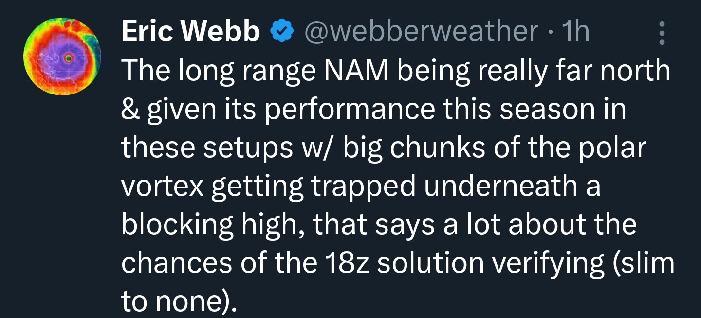
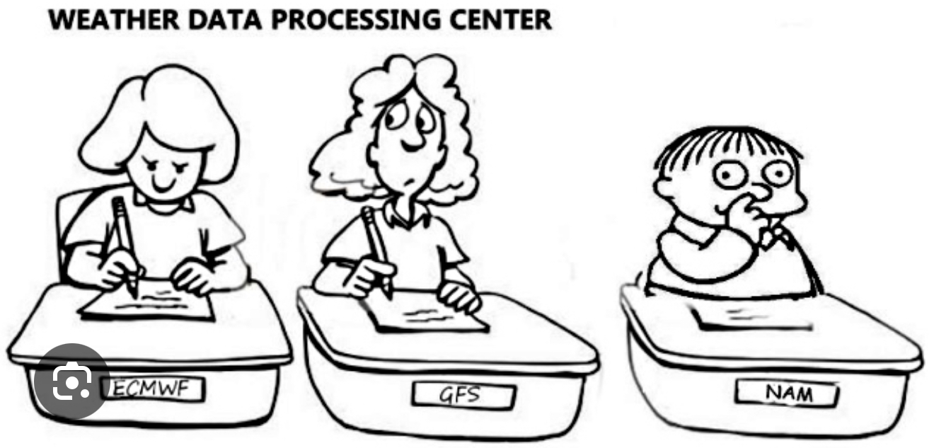
I say it every time. The NAM has a time and place. We just block out all the times it leads the way because it’s more fun to treat it like the stepchild.
-
 1
1
-
-
20 minutes ago, LeesburgWx said:
In case we forgot…

The Euro followed on this one tbf
-
2 minutes ago, 87storms said:
Btw…a great afternoon disco by lwx explaining the latest trends and that it’s not necessarily a wrap yet.
Share please! Need some hopium.
-
5 minutes ago, Solution Man said:
Yes we are very sensitive here, especially when we are failing
Trust me I get it. Probably why I posted something as petty as I did
I’m with my wife in NYC for the weekend and my giddiness yesterday morning turned to a drunken nihilism that she finds amusing when there’s stormfail.
As the pros and far more intelligent folks have said the depiction is definitely funky. As long as one of y’all have hope I will too.
-
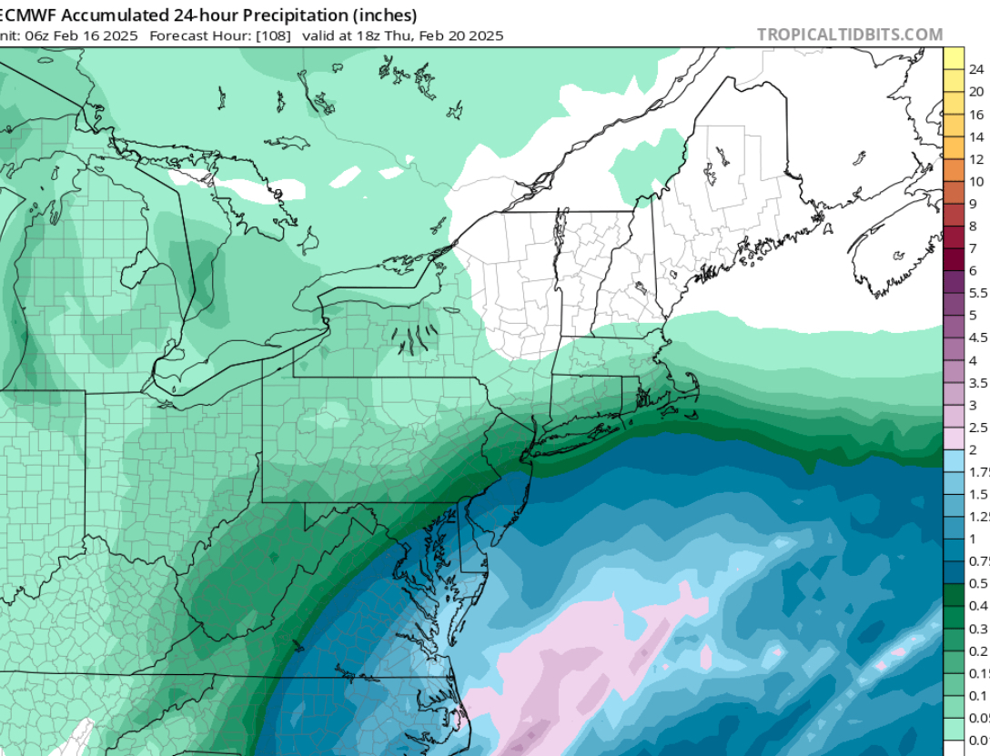
Just now, T. August said:
Yeah not a big deal at all - some maps update later than others so 12z total precip might not have updated yet on TT.
That’s what I just realized too. Thanks.
-
1
-
-
10 minutes ago, Ji said:
Your using wrong qpf mapsThat’s strange. I’m toggling from th
10 minutes ago, TSSN+ said:People need to learn how to read the maps before they post them lol.
Well you don’t exactly expect it to change runs simply because you toggle between snow map and QPF map. At no point did I choose the 06z or any other run.
-
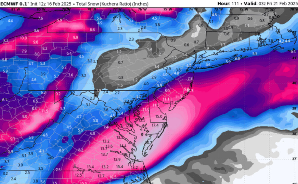
Not understanding the snow maps at all. DC squarely in 0.5”+ yet less than five inches of snow in a cold storm?
I mean I get that snow growth isn’t as good outside the banding but I don’t think globals are very capable of that sort of granularity.
-
 1
1
-
-
5 minutes ago, CAPE said:
There is a literal wall of Arctic HP to our N and NW leading into this event. The baroclinic boundary is suppressed to the south. Seems like some here are overlooking basic meteorology. The low will develop and track along the thermal boundary, and so it isnt surprising that places further SE are favored for the heaviest snow. The ens mean across guidance are literally screaming that this is the case.
No chance it's chasing convection at all?
-
Just now, stormtracker said:

I spoke to him on the phone once when I was in college and considering meteorology. I'd reached out to the station requesting a conversation. He probably thought I was a special individual. I was a little starstruck and kind of blew my shot. Not sure what I wanted to get out of it anyway. Maybe more snow?
-
1
-
-
1 minute ago, stormtracker said:
We can't even use the NAM 24 hours out and you wanna look at it for this storm?
I stand by the NAM. It has it's time and place!
-
15 minutes ago, Paleocene said:
Trop tiddies has the euro ai under the global models, with limited outputs. But only at 00z and 12z. The 6 and 18 runs are on paid sites
Oh wow I notice it now. I just never even bothered to look.
So what's the difference between this model and the operational Euro?
-
44 minutes ago, Heisy said:
We have a met on our discord. One of the best. He pointed out how the AI runs at 28km resolution. It can’t handle convection. “It’ll cave eventually”
It’s getting there
.Where is the AI? I'm an old-timer using TTidbits.
The GFS and Icon push the SLP OTS. But I just thought it outran the northern energy. How can they tell it's chasing convection rather than just outstripping?
-
We knew there'd be a sharp cutoff, but it was modeled to be more N/S. In reality it's been far more NE/SW. Loudon's basically the same latitude as DC yet they're all reporting a bust whereas we're already well into the 4-8" forecast range.
I just measured 4.5", and it's snowing quite steadily. Ratios seem like they may be less than 10:1 so definitely not a bust here.
-
2 minutes ago, nj2va said:
During storms, I don’t look at radar. I don’t want to know when the back edge is approaching nor do I want to know if nearby bands aren’t approaching. Just like to enjoy what falls

This is 55% of the fun for me.
-
1
-

FOLKS Feb 19-20 Debacle
in Mid Atlantic
Posted
The radar looks great. If the models weren't so adamant about this missing south I'd be thrilled right now. It's even moving more NE than modeled.
I'm sure dry air will shave the northern batch right off as it approaches.