

klw
-
Posts
4,499 -
Joined
-
Last visited
Content Type
Profiles
Blogs
Forums
American Weather
Media Demo
Store
Gallery
Posts posted by klw
-
-
2 hours ago, Cold Miser said:
...But will I be able to use this before the end of the season?

Probably when the wheat is ready for harvest.
-
 2
2
-
-
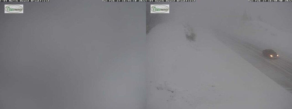
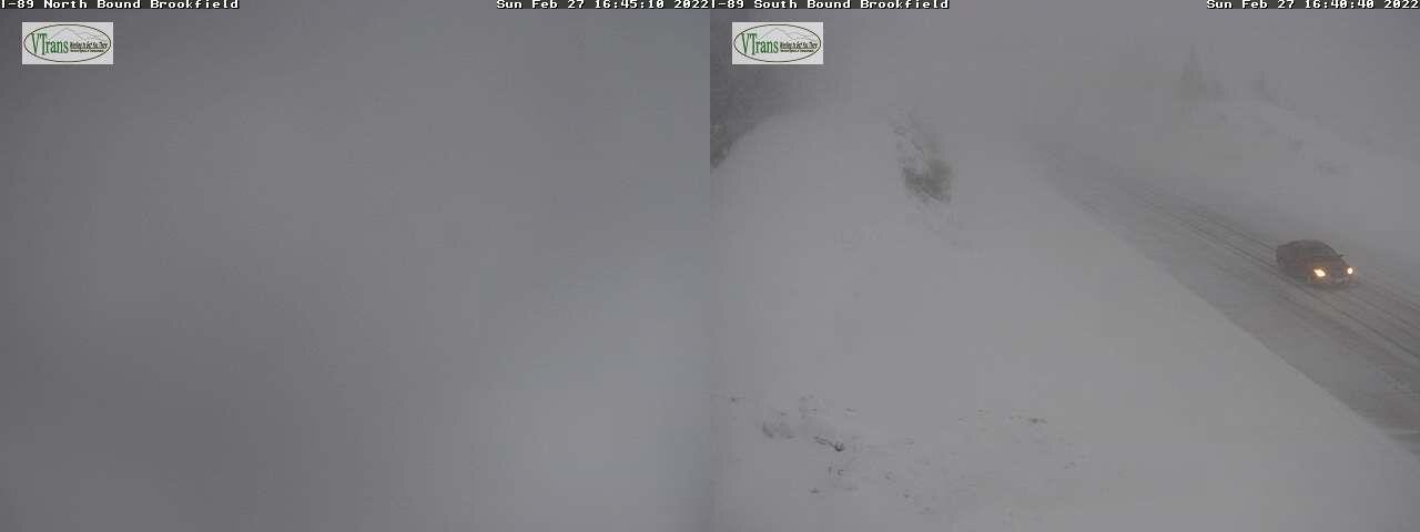
Just got the Snow Squall warning. Meanwhile upstream:
-
I just put seed out for the birds, I was really surprised how much powder there was. I thought the sand base would have made up more of a prominent layer.
BTV has a map out for tomorrow.
-
9.2 inches here, clearing the board showed clearly how we went from dense sand in the first half to fluff in the second.
-
winding down here, 9.2 inches new
-
9 minutes ago, dendrite said:
Midlevel goodies looking good out in NY
Snow has really picked up here in Burlington Vermont
-
 1
1
-
-
Interesting update from BTV discussion:
.NEAR TERM /THROUGH SATURDAY/...
As of 904 AM EST Friday...Interesting morning acrs our fa as
widespread moderate to localized heavy snow continues acrs most
of our cwa. Did get a report from NWS employee in Williston of
some sleet mixing with the snow and sure enough radar shows 35
to 40 dbz pocket in this area, not sure why as soundings are -8C
or colder at all levels. Maybe combination of unsaturated DGZ
and weak instability btwn 15kft and 20kft.

Watching water vapor is pretty neat this morning, as mid lvl
dry slot is quickly pushing into central/northern NY ahead of
potent 5-7h short wave trof over the central Great Lakes. Within
this dry slot KBUF sounding is indicating some steepening lapse
rates within the 700 to 500mb layer, which is closely tied
within the favorable snow growth region. So anticipating as
better dynamics arrive btwn 15z-21z today, a period of moderate
snowfall with embedded heavy snowfall still looks very
reasonable from a SLK to BTV to MVL line. Snowfall rates of 1 to
2 inches per hour with localized up to 3 inches is possible,
given the convective potential per soundings. Just noted a cloud
to ground lighting strike btwn Massena and Ottawa. Heaviest
snowfall should arrive in the btwn area btwn 16z-18z, before
shifting east. Expect very poor visibilities and hazardous
driving conditions. The limiting factor to higher snowfall
amounts wl be quick movement of system and moisture decreasing
aft 21z. Did tweak snow ratios a bit this morning based on obs,
which did make some minor adjustments to the snowfall. Still
anticipating a widespread 6 to 12 inches. Snow ends by 00z this
evening acrs most of the fa.
-
BTV morning discussion.
https://forecast.weather.gov/product.php?site=BTV&issuedby=BTV&product=AFD&format=CI&version=1&glossary=1

NEAR TERM /THROUGH SATURDAY/...
As of 904 AM EST Friday...Interesting morning acrs our fa as
widespread moderate to localized heavy snow continues acrs most
of our cwa. Did get a report from NWS employee in Williston of
some sleet mixing with the snow and sure enough radar shows 35
to 40 dbz pocket in this area, not sure why as soundings are -8C
or colder at all levels. Maybe combination of unsaturated DGZ
and weak instability btwn 15kft and 20kft.

Watching water vapor is pretty neat this morning, as mid lvl
dry slot is quickly pushing into central/northern NY ahead of
potent 5-7h short wave trof over the central Great Lakes. Within
this dry slot KBUF sounding is indicating some steepening lapse
rates within the 700 to 500mb layer, which is closely tied
within the favorable snow growth region. So anticipating as
better dynamics arrive btwn 15z-21z today, a period of moderate
snowfall with embedded heavy snowfall still looks very
reasonable from a SLK to BTV to MVL line. Snowfall rates of 1 to
2 inches per hour with localized up to 3 inches is possible,
given the convective potential per soundings. Just noted a cloud
to ground lighting strike btwn Massena and Ottawa. Heaviest
snowfall should arrive in the btwn area btwn 16z-18z, before
shifting east. Expect very poor visibilities and hazardous
driving conditions. The limiting factor to higher snowfall
amounts wl be quick movement of system and moisture decreasing
aft 21z. Did tweak snow ratios a bit this morning based on obs,
which did make some minor adjustments to the snowfall. Still
anticipating a widespread 6 to 12 inches. Snow ends by 00z this
evening acrs most of the fa.
-
1
-
-
6 minutes ago, dryslot said:
Be very happy if some get 10" out of this.
Especially if by some we mean me.
-
Judging by the very heavy traffic on 89 north and the large volume of LED lit cars, the VT ski resorts will be full of White Platers this weekend who left a day early to beat the storm tomorrow.
-
1 hour ago, J.Spin said:
Event totals: 0.6” Snow/0.43” L.E.
Some models have been showing back side snow in our area from Winter Storm Nancy, but the signal wasn’t all that strong, so I hadn’t given it too much thought. It definitely caught my attention this afternoon though. There were a few flakes falling here and there in Burlington, but as I headed home westward into the mountains, the precipitation ramped up steadily. Accumulations began to appear on the roads around Williston, and by the time I reached the Bolton area I encountered near whiteout conditions with snow-packed roads. Here at the house, the intensity of the snow was enough that I had to put it down as “heavy snow”, since it was in excess of 1-2”/hr. while I was out making the 6:00 P.M. observations.
I ran into this as well. Very harrowing, near whiteout. The lowest speed I saw was about 25. I was in the Prius which has no fog lights so it was very difficult to see where the lanes were at times. Lines of cars developed because the one in front couldn't see bumpkus. I passed a few and regretted it each time. The wind was not helping either.
-
2 hours ago, PhineasC said:
I wonder if PF is still excited about BOS snowstorms as his yard turns into a slushy mud pit.
")
The mud will freeze tonight.
-
I am amazed how every storm how people seem to forget that models tend to have have runs where they trend south about 3 days before storm, trend north about 2 days before, then South about 18 hours later with a last tick north. It could all be in my head but it has seemed to happen every storm for a few years now. With this trend north this morning, we should see a bump south again in the 0Z or 6Z runs overnight.
-
Temps were fun to watch on the drive up 89 this morning. 39 at the house. Jumped up as moved north. It fell from 54 to 37 in less than 4 miles near Montpelier. Bumped back up pretty quickly a few miles later.
-
1 hour ago, RUNNAWAYICEBERG said:
Yea. I pick her up from my MILs every Tuesday night. Got off 84, came around the corner (dark, pouring rain) and thought I was dreaming when I saw something come across the road so I pumped the brakes and braced for impact. Luckily I was going about 30mph and probably hit it at 15mph maybe. Could have been worse.
Eversource expects to have power restored to the remaining 400,000 customers who are in the dark from this tree fall no later than Monday.
Glad both of you are okay.
-
1
-
-
5 minutes ago, Cold Miser said:
I hope those are the powerful LED lights that blind me from behind through the rearview mirror. I like obnoxiously bright headlights.
Hopefully you have an auto-dimming rear view mirror that, like mine, does not dim. It makes things all the more fun when you have someone with their LED high-beams on behind you for ten miles.
-
1
-
 1
1
-
-
2.5 inches total yesterday/ overnight.
-
About an inch here from the steady first part but it looks like the 2nd line is not holding together for here, more south. We'll see
-
17 hours ago, IowaStorm05 said:
There are probably several Dr. Doctorses.

Neurologist Dr. David Doctor:
-
1
-
-
1 minute ago, Damage In Tolland said:
Fish just loves melting pack. Sicko
It looks bleak in the Ottawa River valley if that is accurate up there.
-
42 minutes ago, jculligan said:
I've been a frequent visitor to the White Mountains since I first arrived as an undergrad at Plymouth State University in the autumn of 2001. I'm sure some folks in here have a better memory than mine, but I'm not sure I've ever witnessed the seasonal snowpack being wiped out in the month of February. There have been years where it took a long time to initially establish the seasonal snowpack...but usually once it's there, it stays through at least the end of March. Last year was perhaps the earliest melt-out I've seen, with the possible exception of 2016.
If you lose all of your natural snow next week, that will truly be noteworthy. I don't have official stats to back this up, but...that would be quite a significant deviation from the climatological norm in this area, if not close to unprecedented.
Not February but the Grinch storm of 2007 wiped out my 23" pack in Bethlehem in a day. I think it was 12/23 give or take a day.
-
KLEB (Lebanon NH) went from 54 at 6:22 to 33 at 7:53. Nice.
https://www.wrh.noaa.gov/mesowest/timeseries.php?sid=KLEB&wfo=btv&num=72
-
1
-
-
43 minutes ago, mreaves said:
This was issued by BTV at 5:15 this morning
Just made the drive up 89 to Burlington (BTV). It was 41 as I left my house. 7 miles later I got on the highway in Sharon and it was 34 (where the 45 is shown). 20 miles up the highway it was 23 (where it shows the 52). It was pretty much 52 the whole rest of the way, only took 10 or 15 minutes longer than usual.
-
Currently 55 in West Lebanon and 28 in Barre. 43 here
March 2022 Obs/Disc: In Like a Lamb, Out Like a Butterfly
in New England
Posted
2.0 new here, slowing lightly still