

Geoboy645
-
Posts
714 -
Joined
-
Last visited
Content Type
Profiles
Blogs
Forums
American Weather
Media Demo
Store
Gallery
Posts posted by Geoboy645
-
-
Honestly at this point, I don't know if I really want anymore significant cold and snow. The warmth and rain yesterday felt really nice, and there are already the beginnings of some of our early spring plants coming up. I've frankly forgotten that it is in fact early February a few times. We've had our cold and snowy stretch, and a pretty high end one at that. Let's get an early, warm, and drawn out spring in for once. I know that we will get cold and snow still, especially with the incoming SSW. But man, this stretch has been really nice.
-
 1
1
-
-
In other news. With the warmth yesterday. GRB is now up to a +17.1 (!) departure for the month. And that's probably not going to come down to earth all that much in the next 5-7 days going by the point forecast. Even if we had a repeat of the Mid-January cold wave, and that's not looking likely at all, we'd still be talking about probably at least a +5 anomaly for the month. We have to be pretty much locked in for at least a top 15 if not top 10 warmest February at this point.
-
1
-
-
4 hours ago, CheeselandSkies said:
GHD I was fun; although (at least in Milwaukee, where I was living at the time) the wind caused so much drifting that the snow depth elsewhere didn't really seem all that impressive to me. I have no memory at all of GHD II, as I don't think it affected southern Wisconsin all that much in terms of noteworthy totals.
Yeah we only got like 4 inches of snow from GHD II at least in the Madison metro and points north. It was a pretty ho-hum snowfall for us. It's why Feburary 15 as cold as it was doesn't really stick out as much as other similar months.
-
1
-
-
3 hours ago, Brian D said:
Just looking at daily records, there were some rather mild days in there. Can see how foliage could quickly sprout. Happens when you get a false Spring, and buds come out, then get damaged from cold. Before that pic was taken, looks like a 4 day warm spell. Temps overall look pretty decent. Nothing too cold.
12/1/1931 0 0 37 30 12/2/1931 0 0 41 27 12/3/1931 0 0 48 29 12/4/1931 0.54 0 41 33 12/5/1931 T T 34 26 12/6/1931 T T 36 32 12/7/1931 T T 36 20 12/8/1931 0 0 32 19 12/9/1931 0.55 1 39 32 12/10/1931 T 0 42 34 12/11/1931 0.12 0 62 42 12/12/1931 0 0 47 35 12/13/1931 0.05 0 41 36 12/14/1931 0.21 0.3 42 30 12/15/1931 0 0 38 30 12/16/1931 0 0 46 29 12/17/1931 0 0 49 33 12/18/1931 0 0 46 29 12/19/1931 0.02 0 52 35 12/20/1931 0 0 46 35 12/21/1931 0.16 0 49 38 12/22/1931 0.67 0 52 45 12/23/1931 0 0 50 44 12/24/1931 0.01 0 57 37 12/25/1931 0 0 37 23 12/26/1931 0 0 35 22 12/27/1931 0 0 38 29 12/28/1931 0 0 45 36 12/29/1931 0 0 40 32 12/30/1931 0 0 35 30 12/31/1931 0.33 0 34 27 1/1/1932 1.41 0 40 33 1/2/1932 0.03 0 40 34 1/3/1932 T 0 38 34 1/4/1932 0 0 38 28 1/5/1932 0.4 0 44 35 1/6/1932 0.2 0 52 31 1/7/1932 0 0 38 31 1/8/1932 0 0 41 31 1/9/1932 0.01 0.1 32 30 1/10/1932 0.04 0.4 33 26 1/11/1932 0 0 35 29 1/12/1932 0.54 0 53 35 1/13/1932 0.11 0 56 50 1/14/1932 T 0 55 44 1/15/1932 0.61 0 59 36 1/16/1932 0.11 0.2 37 32 1/17/1932 0.3 0 50 37 1/18/1932 T T 38 31 1/19/1932 0 T 37 26 1/20/1932 0 0 43 36 1/21/1932 0.37 0 47 37 1/22/1932 0 0 48 37 1/23/1932 0.32 0 40 35 1/24/1932 0 0 35 24 1/25/1932 0 0 43 27 1/26/1932 0.49 0.2 39 32 1/27/1932 0.08 0 41 32 1/28/1932 0 0 41 29 1/29/1932 0 0 52 35 1/30/1932 T T 35 15 1/31/1932 T T 19 6 Sum: 7.68 2.2 Count: 62 62 62 62 Average: 0.12 0 42.4 31.6 Median: T 0 41 32 Low Value: 0 0 19 6 High Value: 1.41 1 62 50 The most significant part there are the lows. They went from December 8th to January 30th without a low lower than 20. That's equivalent to like early April for lows for almost 2 months in winter. No wonder stuff was greening up and growing.
-
1
-
-
29 minutes ago, michsnowfreak said:
Any posters from southern Wisconsin, I'm curious. Does the MKE temperature sensor seem to be running warm? I notice that MKE is always warmer than everywhere to the north or south, often even warmer than chicago.
MKE always runs warm relative to the surrounding area during winter because of the proximity to the lake. General Mitchell is within a couple miles of the lakeshore. Compare that to Midway or ORD where they are like 10 miles away from the lake. As we all know, that makes a big difference. See the 1/12 snowstorm where MKE only recorded 8 inches of snow while areas just to the west, at about the same range as ORD and MDW, measured over a foot. This is why MKE isn't really the best measurement site to use as a proxy for the entirety of the Milwaukee metro IMO. However, there really isn't another good one unfortunately.
-
1
-
 1
1
-
-
6 hours ago, Stebo said:
It will be if we don't get some snow/cold in February. December was one of the warmest on records and even with the cold snap this month most places are just barely below normal and we are looking at warmth coming in next week that should take away any negative departures.
To put it in perspective, before the cold blast Madison was running a +9 departure for the month. Even with all the cold of last week the lowest the departure got was ...-1.... Now with the warmth from a couple days ago to the end of the month its shooting up again. We are now back to exactly 0.0, with the next 6 days above to well above average.
-
2
-
-
4 hours ago, michsnowfreak said:
Agree on all counts. Its like inappropriate touching to the fanatics to point out cold/snow extremes. No one is denying climate change, but the Great Lakes/Midwest is a region with cold winters/hot summers, so most winters, no matter how "warm" they are in the mean, will have some cold/snow stories to be had. And quite honestly, back to the graph chinook posted, I am quite surprised what a bout of deep winter this region saw for a strong Nino. I knew we would have cold shots and snow while some were on a ledge in December, but did not foresee a blast like that. Hoping some more fun is had in Feb/Mar.
So much of the season to go, but year-to-year rubber-band snaps can be wild. Locally, there were insane ones from 1880-81 to 1881-82, 1917-18 to 1918-19, and 1981-82 to 1982-83. But the 5 year period from 1877-1882 was downright wild.
1877-78: warm
1878-79: cold
1879-80: warm
1880-81: cold
1881-82: warm
That whole stretch from the 1877-78 Nino all the way until like 1890 was just a wild 15 years in the Midwest. Madison had a similar snap back and forth in record warm and record cold winters in that stretch. Including what was likely our snowiest winter ever in 1880-81 if the precip totals from melted snow are to be believed. Also 1880-1885 was our wettest 5 year stretch ever until arguably 2015-2020, with what is probably one of if not the biggest flood in state history in June 1880. The Wisconsin River had a flow of over 100,000CFS at Wisconsin Rapids, the only gauge with records that far back. Later on 1887-88 was a record snowy year further north in Green Bay, where they recorded almost 150" of snow that winter, and then followed up with 120" two years later in 1889-90. The next snowiest year is "only" 93.5" in 2010-11. We really didn't have a crazy stretch like that again in regards to precip and snowfall totals and whiplash really until the late 2000s, and its been like that ever since.
-
1
-
-
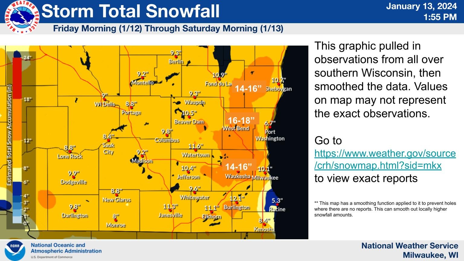
Final total map from MKX. Pretty good verification for MKX and the models as a whole. We were pretty much locked in for at least these totals from like Wednesday morning no matter what the trend was, so to have that verify was very nice. We probably have about 14-15" of snow OTG between the two snowfalls this week. And now with this little clipper coming in the temps have really started to drop. Low clouds with peaks of sun, snow blowing around and lightly falling, and the wind blowing. It is positively arctic out right now. Since I wasn't around here for Feb 2021, this is the most "deep winter" conditions I've experienced since late Jan 2019.
-
2
-
-
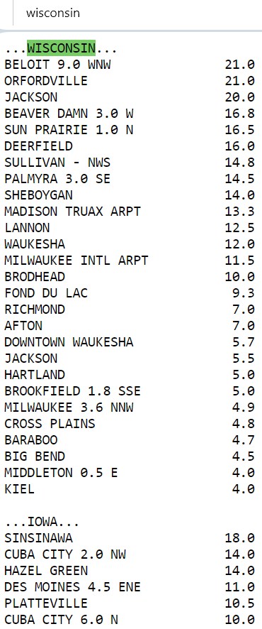
Also fun fact, because of the snow wednesday night occuring over midnight. Madison now is on a 3 day stretch of recording over an inch of snow, which is already the 6th longest on record. We will definitely get 4 today and most likely get 5 tomorrow. Which would tie the stretch from 12/15/74-12/19/74 for the most consecutive days with an inch or greater snowfall on record.
-
3
-
-
9 minutes ago, madwx said:
around 9". drifts are impressive, it's all fractured dendrites now. wind is steady but will really pick up from the NNW after sunset
Yeah I would not want to be out in the country after nightfall. I went out of town a little bit a couple hours ago on the backroads and it was already pretty bad. It's going to be basically impossible to go anywhere after nightfall once the wind picks up. I'm guessing our totals are pretty similar to yours, maybe a little less. But it is hard to tell at this point.
-
3 minutes ago, Malacka11 said:
I mean in a twisted sort of way I suppose it's our revenge no
I mean he finally got banned and within 10 days we get two major snowstorms and are now about to have a big cold blast after we had a record warm December before he got banned. It's only weird if it doesn't work.
-
1
-
-
19 minutes ago, madwx said:
should jackpot this and may even jackpot Friday's storm. will get pics of the upcoming glacier
Yeah with the water content of the base and the upcoming cold blast. This snowpack isn't leaving anytime soon to say the least.
-
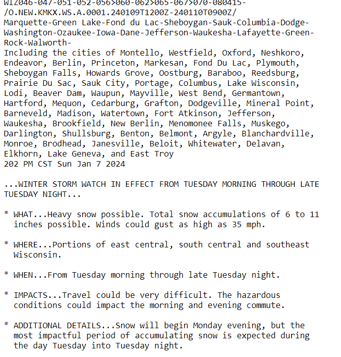
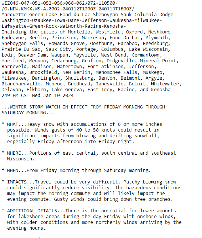
And now MKX has their watches out.
And all I am going to say to that is...
-
1
-
 1
1
-
-
3 minutes ago, madwx said:
hoping for some sunshine. This is the most climatologically favored time of the year for this cold so not expecting any records
Yeah that's what I'm looking forward to as well considering I think we have maybe had 6-8hrs of sunshine since December 19th. But yeah this is basically right on schedule for our cold waves so there really won't be any records I don't think. It'd be nice to actually have a cold wave like this on January 15th though, feels like its been a while since we have had that.
-
1
-
-
The models have been in pretty good agreement for the last couple days that after the big storm on Friday and Saturday, we could get a legit cold wave for at least the early part of next week. Some runs have had temps as low as the -20s for overnight lows. And while it doesn't look like wind will be quite as big of a factor at this point compared to January 2019, WC's will still probably be within warning criteria as well. Whatever areas max out on snow from this weekend, especially if they maxed out on snow yesterday, could really get down in temperature.


-
 1
1
-
-
57 minutes ago, madwx said:
31/29 here. should be off to the races once it starts. would expect snow to begin in 2 hours or so. models have backed off morning snow a bit here but really get things cranking with the defo band in the afternoon
Yeah this is looking like its going to be anice hit for us. But I am not looking forward to the drive on 151 during that defo band tomorrow afternoon and tomorrow night. That's not going to be fun.
-
1
-
-
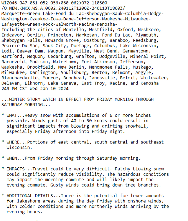
MKX just came out with their Winter Storm Watches and they have decently strong wording all things considered.
In fact, with those totals and gusts I wonder if we don't see the B word come out at some point. Some of the open areas are going to be pretty close to that threshold I think on Tuesday.
(If you saw this on the other thread, no you didn't)
-
1
-
1
-
-
Well the next 4-5 days look like 40's and 50's with rain. A nice forecast that will get greenup going with no real frost in the forecast. Seems like we are finally turning the corner into Spring. A pretty typical first week of spring forecast.... wait what do you mean it's the first day of winter?!
-
1
-
-
17 hours ago, Chinook said:
Anybody remember this snow storm? It sort of maxed out in and near Cedar Rapids to Madison Milwaukee on 2/6/2008

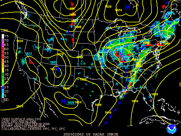
This storm was really the first snowstorm I remember somewhat completely. If I recall it had blizzard conditions for a while at Madisn. This is the one that caused the interstate to close between Madison and Janesville, leading to a bunch of people being stranded for quite a bit. It's the reason why there are crossing gates at select interchanges in Wisconsin on the interstates. This storm, the 6/7/08 tornadoes, and the 08 flooding are the events that really got me into weather. I would love a repeat of this storm, without the people being stranded of course.
-
3
-
-
This incoming rain event over the next couple days looks to be a real drought helper if not a complete buster. Pretty good shot at widespread 1-3" of rain over most of the drought areas. For some spots in S MN and Iowa that have really missed out on the rain this summer. This could legit double their 90-day rain totals at least according to AHPS. Overall a very welcome rain, even if a bit late for crops and the harvest.
-
2
-
-
2 hours ago, michsnowfreak said:
LMAO @Stebo do you want to do the honors? I guess accurate temps and not running 2-6° warmer than every surrounding station means the sensor is in an ice bath.
I answered my own question re: SE WI. All you have to do is look at the daily RTP to see MKE runs noticeably warmer than almost everywhere.
https://forecast.weather.gov/product.php?site=DTX&issuedby=MKX&product=RTP&format=ci
To expand on this, MKE is located at General Mitchell Airport. General Mitchell is not only well within the UHI, but also dramitically affected by its distance to the lake of only about 2 miles. This is why sometimes MKE really isn't the best gauge for the entire Milwaukee metro or even the city.
-
3
-
2
-
-
28 minutes ago, OrdIowPitMsp said:
Mississippi River north of the twin cities is near record lows. Currently below the low water threshold.
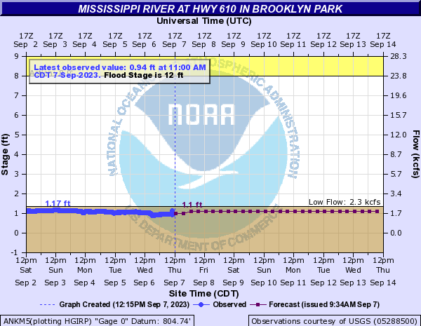
Hard to believe that that gauge was at major flooding for an extended period of time not more than 5 months ago.
-
-
Interesting note, there is currently a Red Flag warning for the SW and Central areas of Wisconsin. From what I can tell at least since IEM records start in 1986, this is one of if not the first time that these areas have been under a Red Flag warning at this time of year. In fact this is only the 10th time MKX has ever issued a Red Flag warning in general. Not very surprising considering the drought, and with the holiday weekend there are certainly quite a few potential ignition sources. Especially considering that people don't really think of fires all that much in this part of the country, and especially not outside of March/April during our usual fire season.
February 2024 General Discussion
in Lakes/Ohio Valley
Posted
Well we ended up with a nice 2-3" of snow from this storm. Classic mid-March storm with the rain at the beginning last night and then turning over into slushy snow overnight. Its become sunny now and the snow caked on the trees is really pretty right now before the sune melts it. Will have a nice cooldown into the 20s the next couple of days, but right back to average in the upper 30s and 40s on Sunday. Talk about a perfectly stereotypical mid-March pattern....wait what do you mean its February 15th?!