

Geoboy645
-
Posts
714 -
Joined
-
Last visited
Content Type
Profiles
Blogs
Forums
American Weather
Media Demo
Store
Gallery
Posts posted by Geoboy645
-
-
11 hours ago, michsnowfreak said:
Clearly the east got the brunt of it. Im not as familiar with their summer climo so I really didnt follow where this would rank.
Kind of surprised that none of their subs even have a thread for it.
They won't have a thread for one of the worst heatwaves on record for their area, but will have a thread for an hr 240 Noreaster on Nov 15th...
-
 1
1
-
 7
7
-
-
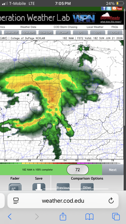
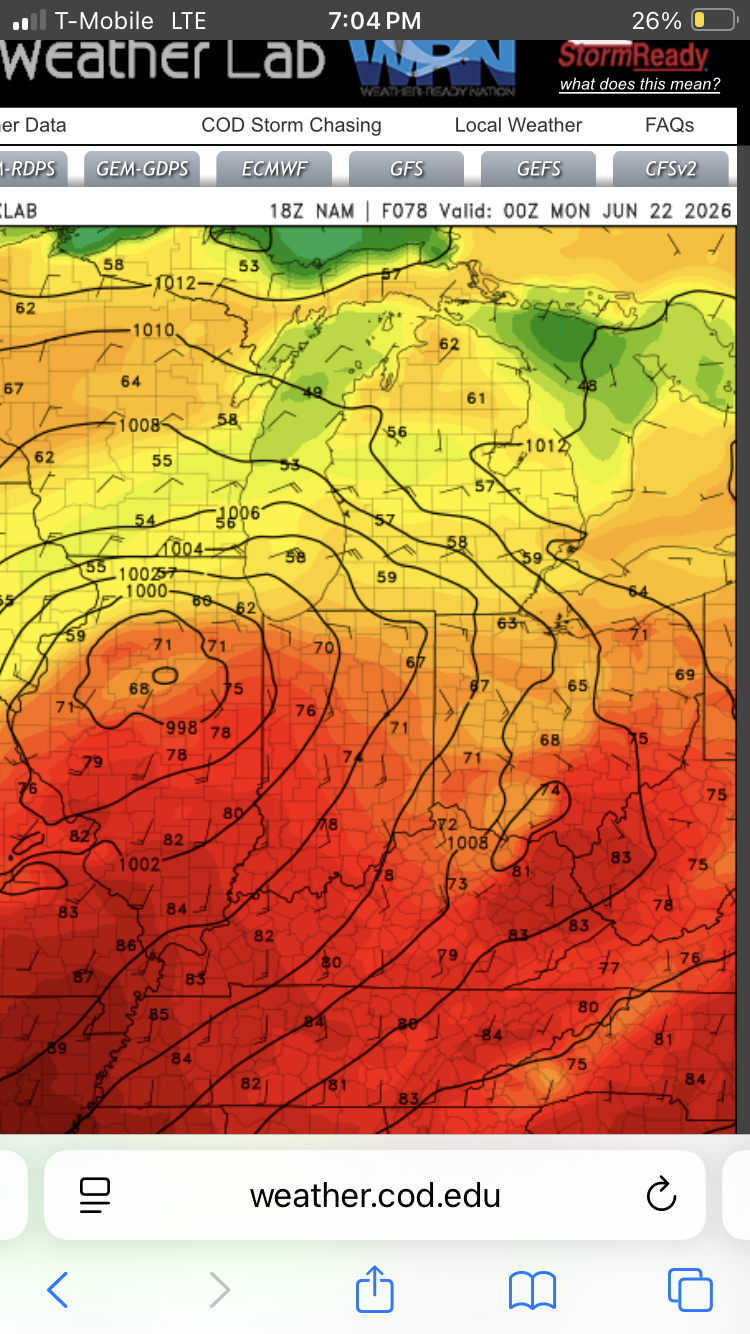
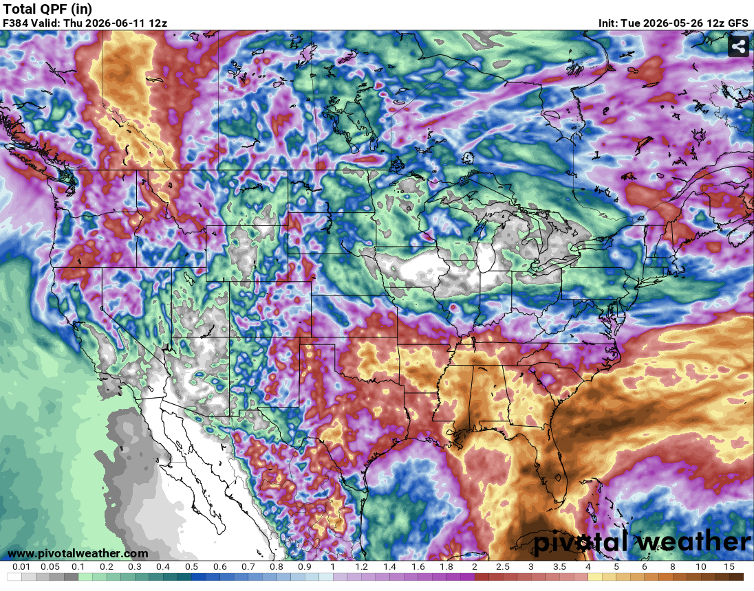
It is looking like the Midwest is in store for a prolonged and impactful heatwave through at least next week into the Independence Day weekend. The point forecast for Madison has 90s everyday from Monday on, with 70s if not mid to upper 70s for lows. It is currently cooler right now than it will be at the coolest part of the night after Monday. Models have been consistently showing the heatwave continuing into the extended range. While forecast highs don't look record high as of this juncture, the length of the heatwave coinciding with the holiday week could lead to higher impacts, as outlined by the WPC.
-
4
-
-
1 hour ago, BeastFromTheEast said:
Defo bands in June
 Money man , Cromartie special
54 and rain at 0z on the 22nd of June would be something.
-
4 hours ago, A-L-E-K said:
euro selling death valley qpf
gonna get ugly quick
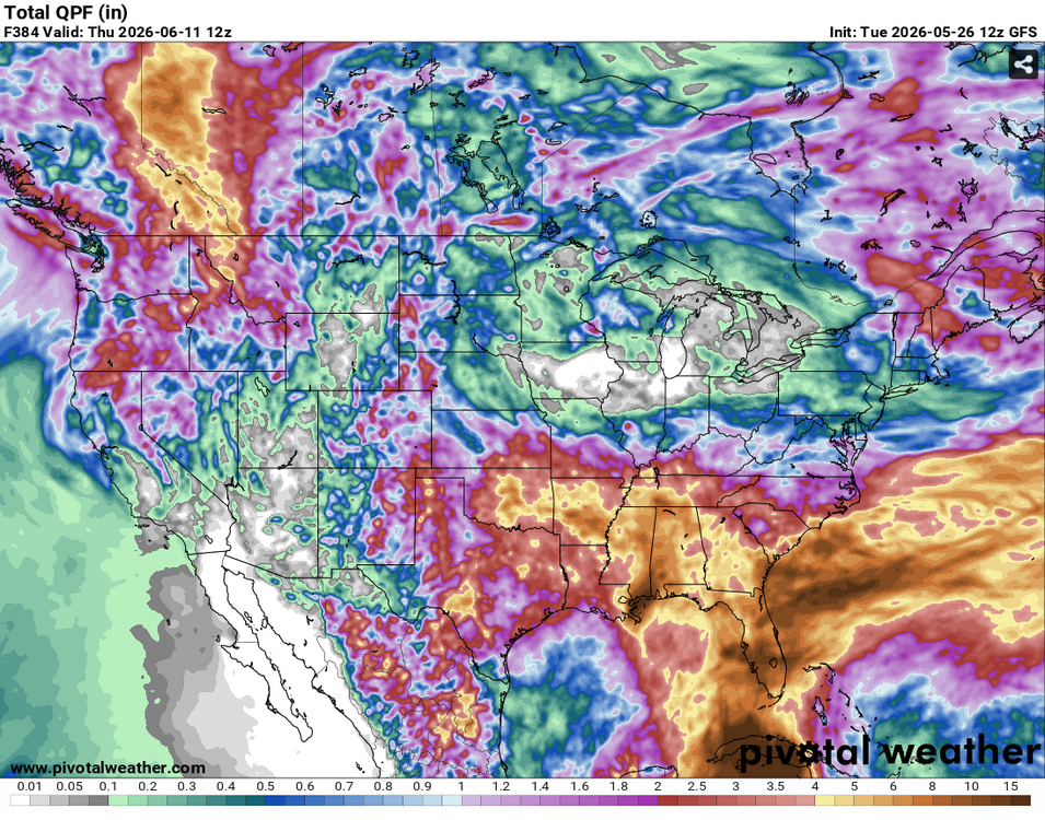
We are going to be thanking that we had the extremely wet March and April here because yikes. Between that and the ridge to the N causing fire weather up in Canada, wouldn't be surprised if we June 2023, again.
-
1
-
 1
1
-
-
Pretty incredible stretch of temperatures coming up for Mid-April. We have had warmer, and similar length stretches of warmer temps. But having 70s and humid for at least 5 days straight is impressive, as usually it's dry when we get warm for that long this time of year, ala 2023. Going to be stacking up the rain totals as well, especially if areas have multiple rounds of T-storms. Could be a significant flooding issue in the UP and basins coming off of that area and the North Shore where there is still a significant snowpack. GRB has noted the possibility of the Menominee River reaching moderate or major flood stage later in the week. That plus the multiple severe days is going to make it a very busy week for the region.
-
3
-
 1
1
-
-
1 minute ago, madwx said:
1.17” with this low. 3.5” so far this month
Yeah we are probably in the 3-4" of rain range as well over the last few days up here. A lot of the usual spots are starting to get into action or minor flood stage, except Ontario on the Kickapoo which is somehow in major stage. Next week's system is going to be something to watch for flooding, as it's going to take a few days for everything to dry out. And just like that we go from worrying about drought to flooding. Again.
-
 1
1
-
-
Event is already about to be underway here. But there should be a thread for a 10 percent and a 70/40 watch.
-
1
-
-
I'm in short sleeves at 930pm in March. Less than a week after having a historic blizzard. What a strange month, even for March. It's frankly kind of unnerving just how warm it is outside rn.
-
1
-
-
We went from 70 degrees on March 9th to 40-50mph winds on March 13th to freezing rain on the 15th and 10 inches of snow on the 16th to 25 and sunny on the 17th and now 63 degrees yesterday and a forecast of 70 today. One of the craziest March rollercoasters for temps we have had it feels like.
-
1
-
 1
1
-
-
Looks like we ended up somewhere in the 10" range here. Very hard to tell exactly how much because of the drifting though. Sun is starting to peek through here, although we still have several hours of blowing snow to go before it finally calms down. Will be interesting to see how long this snowpack lasts both around here and in the extreme totals up north. With 3/25/23 it took about 5 days to melt everything but the largest piles. But that was a bit later in the year and a wetter snow with some rain as well on top of it. We are supposed to hit the 50s by Friday, but we will see how much the snowpack reinforces the cold air even with March sunlight. Crazy to think that this is about the same amount of sunlight that we had when were in the upper 80s in late September last year. All in all, a very memorable storm for the state of Wisconsin and one that will be talked about for a while like the 2018 storm.
-
2
-
 1
1
-
-
Milwaukee has officially put a blizzard warning now. First one since 12/20/12 here.
-
3
-
-
Wausau still looks like the winner so far with 24 inches reported around 2 a few miles west of town. With the defo band still to come they may get to 30+ before it's all set and done.
-
4
-
-
48 minutes ago, madwx said:
Been a sleet/freezing rain fest for the past couple hours. Bright banding overhead is pushing reflectivities very high
Yeah the trees are starting to get the freezing rain look right now. This could be an issue once the change over happens and the wind starts to pick up.
-
6 minutes ago, madwx said:
Been hovering right around freezing. Rain with sleet mixed in during the heavier returns. No ice on roads but sidewalks are definitely slippery
ETA this is definitely running a bit colder than models showed yesterday
Yeah I think we are going to have changeover sooner than expected here.
-
1
-
 1
1
-
-
1 minute ago, DocATL said:
To a firmly Minnesota, Wisconsin, Northern Michigan snow event. More likely spots for mid March.Always has been one of those events though?
-
1
-
-
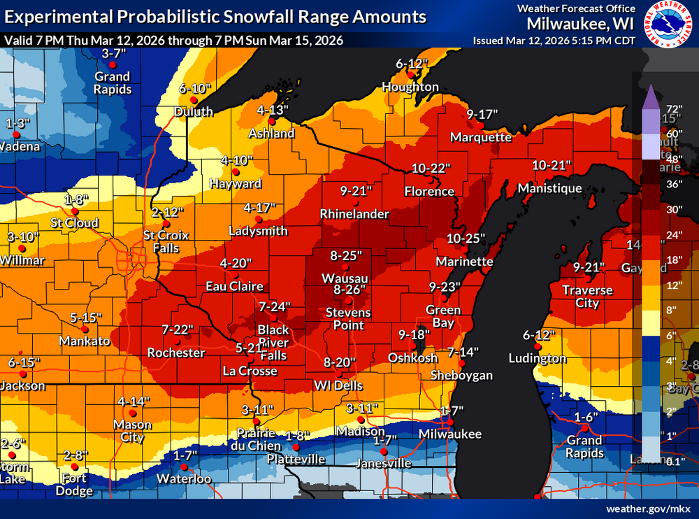
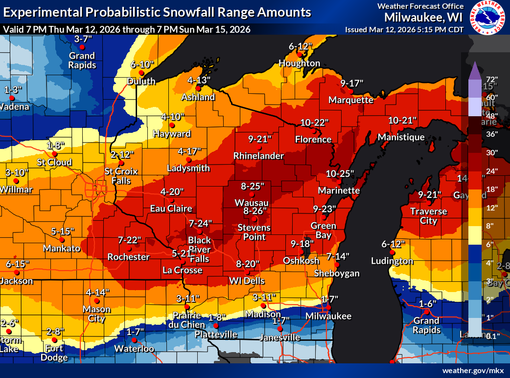
Well the probabilistic forecast is out through Sunday N and hoo boy. Normal caveats with this and some of that is affected by tonight's clipper. And it's still snowing probably another 12 hours after the end of the period on the map.
-
1
-
-
So interesting fact, the high wind warning issued for tomorrow is only the 7th one on record for Columbia County according to IEM. 12/15/21, 2/24/19, 3/8/17, 3/16/16, 2/21/14, and 10/26-27/10 are the only other times that we have had one issued. I knew they were rare here, but I didn't realize that rare.
-
On one hand, it feels kind of early for Winter Storm Watches. On the other hand, we are only two days out from the storm with one of the strongest synoptic wind events in years here tomorrow during the day. This one is going to catch some people by surprise, especially after Monday's warm temps so I'm not surprised that they went with them as soon as they could.
-
2
-
-
40 minutes ago, josh_4184 said:
Snow is certinlty impressive for who cashes in, but the ice is the bigger story, if it remotely verifies somewhere is Michigan will be beyond catastrophic. Northern Michigan already has PTSD from last years storm almost exactly a YTD. My area is right on the edge dont think Northern Michigan can take another once in a century ice storm for the infrastrcuture. Electric bills have gone though the roof since last year already not to mention woods have been decimated and many areas still havent fully recovered regarding property damage.
If that most recent run of the Euro is to be believed, some of those areas that get over half an inch in WI and MI get 6-12 or more inches of heavy wet snow on top of it with the wind. If that happens, that would be catastrophic, including in some areas that were affected by last year and yesterday. I would rather have the straight 20 inches of snow here than deal with ice and then snow like that.
-
Arguably this storm has actually had a high amount of agreement of models for this far out. We know that somewhere in WI is going to get hit with a very significant amount of snow and have a rough idea of what that corridor is most likely going to be. That's pretty good for 3-4 days out all things considered.
-
3
-
1
-
-
11 minutes ago, A-L-E-K said:
DSM through Madison has had a good winter iirc
Yeah it's been a good winter here. Had the fast start like everyone else, but had that very localized 10 inch snow in mid January right before the cold blast that gave us snow depth for it. However, I do not care for some of these solutions to say the least. Two feet of fluffy cement snow and wind is bad, very bad.
-
Some of the model runs are uhh something for this area that's for sure. There is definitely a lot of moisture around to the S so I am not totally discounting higher totals. A late major snowstorm is a pretty typical thing around here in a transitioning Nino spring. With the recent notable examples of 4/13-15/18 and 3/25/23. However, being so warm ahead of said storm is unusual. Could be a very interesting start to next week here.
-
1
-
-
2 hours ago, A-L-E-K said:
feels like the long term dry pattern has been hanging tough for a couple years but we get just enough soakers at the right intervals to keep from ever drying out too much
a prolonged wet and active spring would be a welcome change of pace
That seems to be the pattern most of this decade with the exception of the first half of 2024, at least here in S WI. Long periods of nothing interspersed with about 6 weeks of precip and storms, followed by another 2-3 month stretch of nothing. Hopefully we can get enough precip in the Spring this year.
-
1
-
1
-
-
7 hours ago, cyclone77 said:
Good chance that here and the QC finish Feb with <1" of precip for the year. Really hope meaningful precipitation events return in March or April.
Yeah outside of the 11/30 snowfall and a rain event in early January we haven't had a significant precip event essentially since mid August. Hopefully this incoming active Pacific pattern has some widespread precip events in the next few weeks otherwise we are going to have some Problems as early as April. Especially if we have another Smoke Drought in May and June like 2023 which is a distinct possibility this year.

July 12th and Beyond Heatwave
in Lakes/Ohio Valley
Posted
Yeah this is looking like a potentially very significant heatwave for the northern areas of the subforum. Temps look like they will max out in the upper 90s or even the rare 100s. There has been like 5-6 heatwaves that have led to 100s that far N, and unlike those ones it won't be that hot here as well. Paradoxically, you will have to go south to cool off early next week. This heatwave also coincides with the peak tourist season up N, which could compound heat effects as people are in cabins or campers that are not equipped to handle a couple of days in the upper 90s-100s with 70 degree lows in between.