

Negnao
-
Posts
271 -
Joined
-
Last visited
Content Type
Profiles
Blogs
Forums
American Weather
Media Demo
Store
Gallery
Posts posted by Negnao
-
-
1 minute ago, Paleocene said:
NAM Is running now, I am ready to cling to its definitely inaccurate surface precip projections in the 72-84 hour range to hallucinate snow IMBY!!! But seriously that cold difference shown above for 6z would be huge to say the least for the front end thump. We need something to hold on to hope with y'all.
The globals have pretty much formed a consensus or close thereto and it’s a Mason Dixon and north snow event. Would be shocked to see it shift this close to the event.
-
 1
1
-
-
 Can’t make this stuff up.
-
 4
4
-
-
Time to start rooting for it to just go away. That’s better than a soaking cold rain while they get hammered just to our north.
-
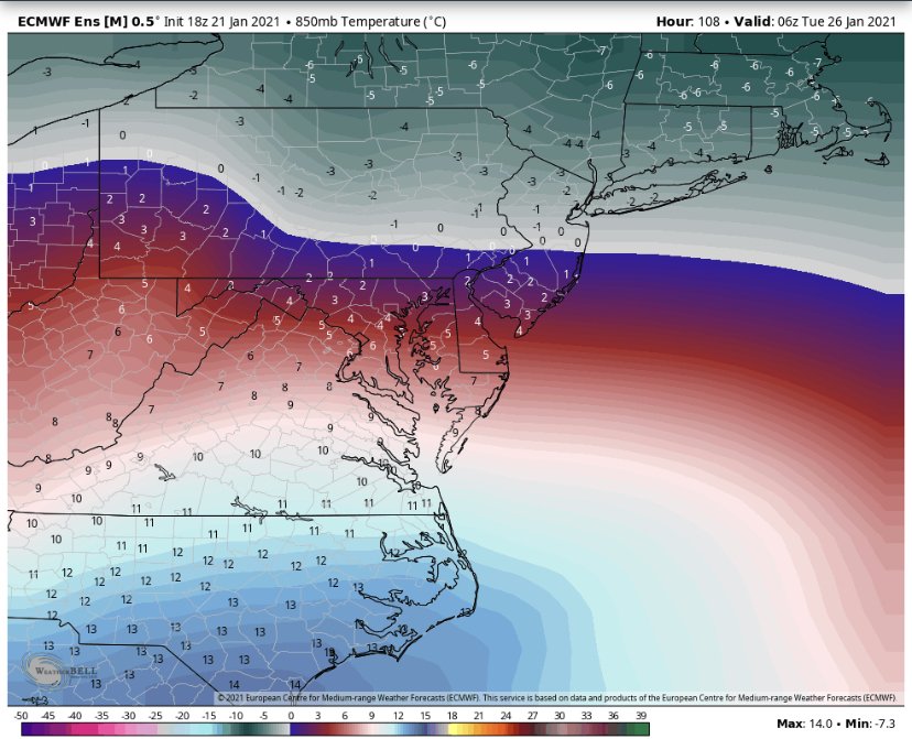 850 temps are boiling.
-
1
-
1
-
-
Just now, NorthArlington101 said:
Not an in-depth analysis or anything but the 18z EPS looks warmer and maybe slightly more amped. Snow mean reflects that.
It’s hideous. Not even close.
-
1
-
-
11 minutes ago, Cobalt said:
ICON suddenly trended warmer at 6z, but is back to a somewhat colder solution. It's a strung out mess however, yet it still manages a med range WWA snowfall for many
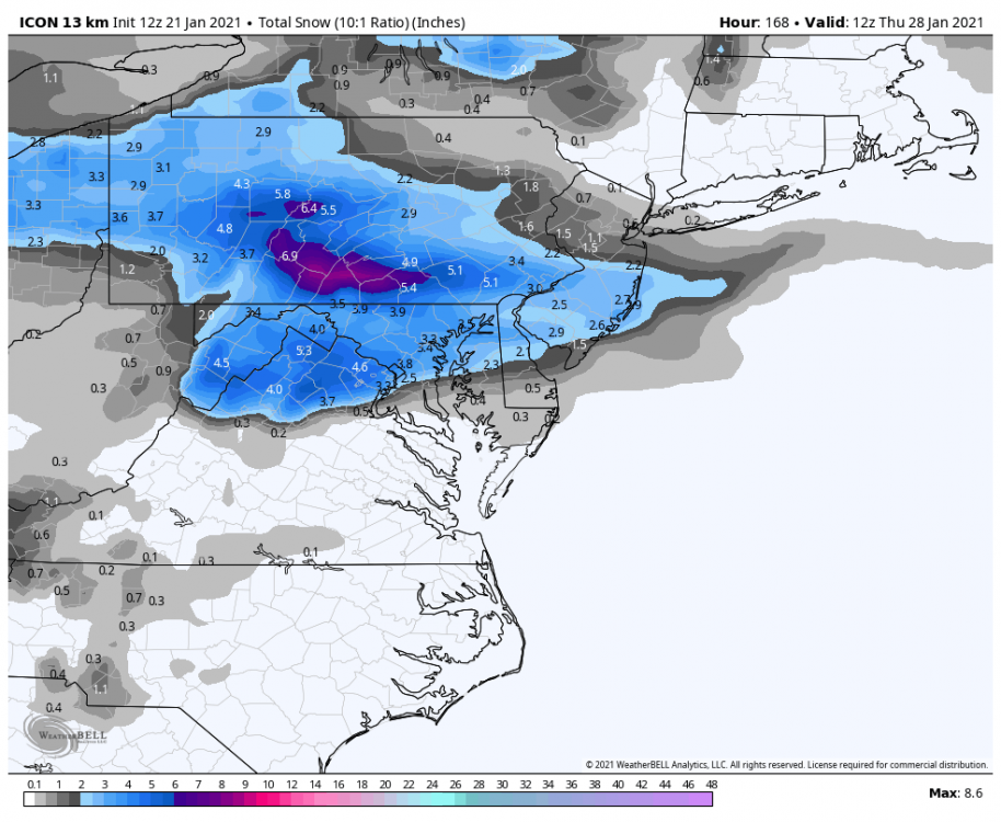
The strung out solutions seem to be the way we score. The consolidated amped storm seems to be too warm.
-
1 minute ago, CAPE said:
HH is a DISASTER.
Look at that hammer diving down out of Ontario. No way the storm can gain latitude with that. That was less pronounced several runs ago.
-
-
3 minutes ago, Ji said:
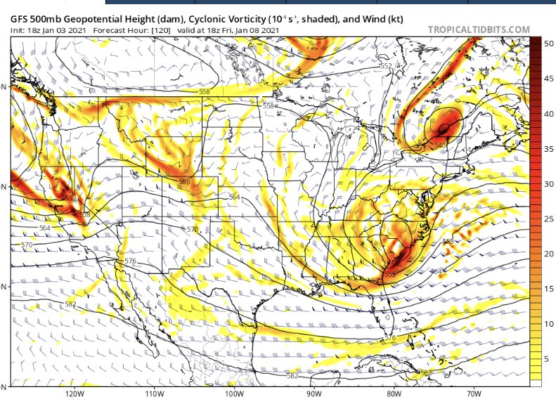
the next event is looking interesting. Lets see what weird way it puts green over us
Check out the para gfs. Great run for 1/8
-
 1
1
-
-
2 minutes ago, yoda said:
Looks like 00z CMC is going to miss south of us for right now for the 8th... fine by me. Gets crushed because of what happens in NE Canada at h5
Dramatically colder on the Canadian at the surface as well.
-
3 minutes ago, nw baltimore wx said:
What the heck is going on in here today?
We need a snowstorm to bring us all back together again.
-
13 minutes ago, psuhoffman said:
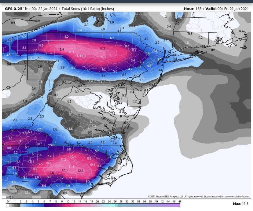
If that track verifies I guarantee you Philly doesn’t get that much. Maybe a few inches. NYC won’t get prolific #s but their saved a reasonable storm because it does eventually hit the brick wall and turn due east. There is a block. But it exerted its influence ~100 miles too late for DC to get a big snow. CAPE pointed out, and was right, that the block is centered a little north of ideal for us. Still it was good enough to work if other things went right. We don’t need PERFECT. But the trough digs too far west and pumps ridging ahead of it and the 50/50 is just a little too far NE to prevent it. NYC is far enough north that it barely saves them. At least to an extent. The big totals will be in central PA and North of them.
Thanks for the feedback and agree with all of the above.
-
5 minutes ago, psuhoffman said:
Ok I think some are over analyzing a run where the low tracks OVER BALTIMORE!!!! Hopefully it’s wrong. But come on. If the low actually tracks from Richmond to Baltimore to Wilmington anyone from 81 east and south of York PA is screwed. We know that. This isn’t that complicated. Just hope that track is wrong. If you get the 12k NAM or GFS track with the euro storm presentation we get a big storm 95 NW. unfortunately the best guidance at this range we have looks like poo. No one mentioned both the RGEM and HRDRPS look awful and had their worst runs at 18z. I am rooting for the gfs but...it’s the GFS lol. Other then the GFS and 12k NAM everything else I saw continued to degrade at 18z.
A low tracking to Baltimore is not the kind of track that produces snow in philly or NYC. Interesting that no matter how bad the track is they seem to score from this storm.
-
Just now, high risk said:
Ok, but the HRRR has been running stupidly cold for winter precip events at longer ranges. For today's cold rain, a couple of the longer range runs had 4-6" through the DC area.
This is entertaining
-
 2
2
-
-
2 minutes ago, CAPE said:
Who cares what the wonky surface maps look like. This looks interesting.

Noticed this wonky stripe through the corridor on the run to run tab on weatherbell for the 850s. Take this out and it’s a cleaner regional improvement in upper level temps.
-
1 minute ago, SnowLover22 said:
Added Bonus gfs screws over NYC and New England. Best news all day.
It’s more progressive than the mesoscale models which is what we need.
-
7 minutes ago, Buddy1987 said:
Theme thus far with the 12z suite is to have confluence a little stronger. That IMO is an important takeaway. Icon and nam both show this.
@75 Icon has low over or just to the southeast of WilmingtonMets are probably laughing at this model but 78 over Hatteras 81 pretty well off shore of Virginia Beach (ala reminds me of 0z GFS from last night) then the wheels fall off from there because the low becomes super jumpy and has some weird double barreled low structure south of Long Island to where I’m assuming some sort of convective feedback issues etc.
We need the low to not take that north jump once around Norfolk. We need it to be more progressive and easterly/more out to sea. The rgem as well as some others show a jump north up the bay, which wrecks our mid levels. Need it more progressive.
-
Just now, Snowchaser said:
Ice blizzard

Doubtful it will materialize as ice. Temps low to mid 30s. More rainy than icy.
-
30-40 mph wind gust accompany this driving rain.
-
2
-
-
2 minutes ago, Weather Will said:
99

Navgem jumped on a slightly more progressive progression.
-
1 minute ago, NorthArlington101 said:
don't think ICON 850mbs are available but almost everyone loses 925s, other than the mountains. Way different than GFS/EURO. Honestly, I think it's tossable.
The transfer to the coastal low is much later than the successful runs we’ve had like the Canadian from yesterday.
-
2 minutes ago, osfan24 said:
This may come as a shock to you, but literally all but a handful of posters on here are basically Northern VA and north. Most are DC and MD. No one here cares about Richmond.
I thought Richmond was in the southeastern forum as it’s southern VA. I love DT’s information and posts though, so if that means we have to take Richmond, i guess it’s worth it.
-
1
-
-
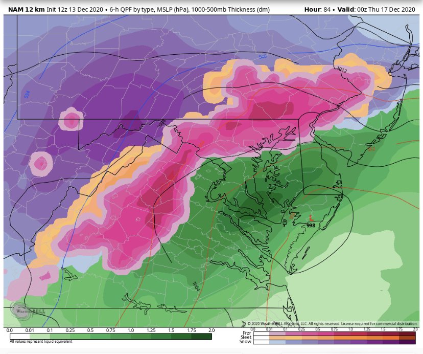
31 minutes ago, Weather Will said:
WB 18Z NAM...flurry watch in effect for SE VA...

-
2
-
-
Fall line storm. Climatology takes over.


Jan 25th Wintry Mix Obs and Nowcasting
in Mid Atlantic
Posted
Dc is more than 50 miles from a snow event on this one. That’s the problem.