

Negnao
-
Posts
271 -
Joined
-
Last visited
Content Type
Profiles
Blogs
Forums
American Weather
Media Demo
Store
Gallery
Posts posted by Negnao
-
-
2 minutes ago, Always in Zugzwang said:
How's it look compared to 18Z? I'm only on TT and it's not out too far there yet.
Good run but the primary holds on a little longer than 18z. Nice thump then we mix.
-
 1
1
-
-
1 minute ago, clskinsfan said:
Exactly .5 all snow in the cities and peoples heads are exploding?
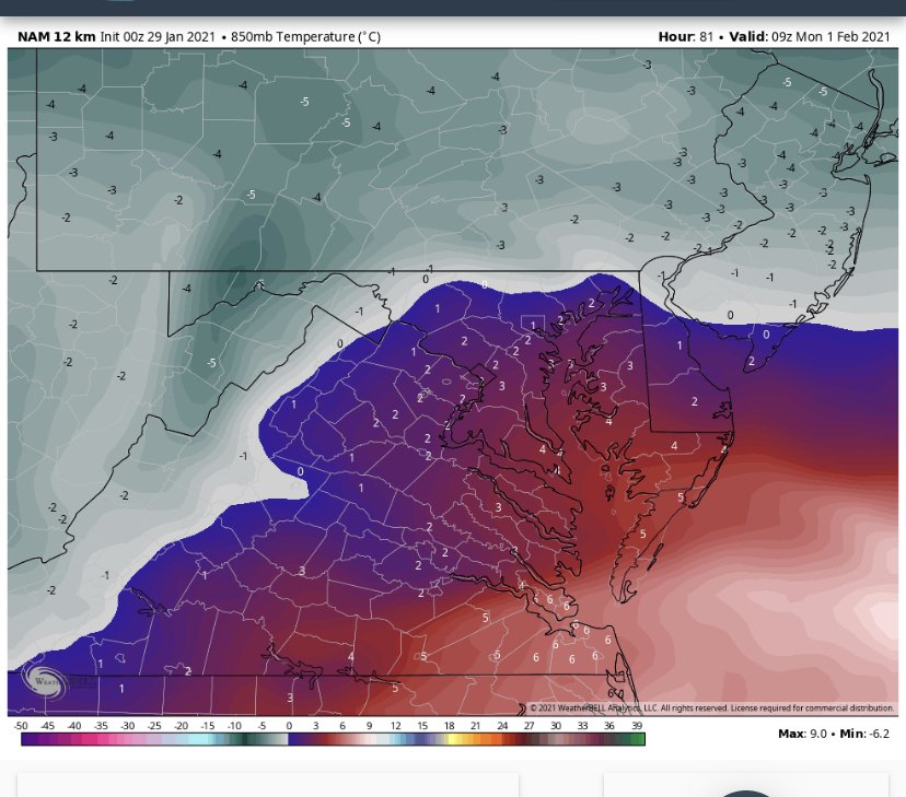
Nice thump but these are some ugly 850s
-
 3
3
-
-
Just now, clskinsfan said:
Of course they do. They are in Richmond.
I meant ppl in this forum. We use state lines as arbitrary lines but our climate is closer to Philadelphia than Richmond for much of the forum but we don’t bark when Richmond ppl chime in.
-
 1
1
-
-
9 minutes ago, BTRWx's Thanks Giving said:
You're welcome here as long as you don't write biased regional posts.
Washington Dulles annual snowfall is 22 inches which is the same or more of than Philadelphia International airport. We have ppl in Richmond and they get much less snow.
-
6 minutes ago, psuhoffman said:
This run would crush DC. The CCB is developing right over them at 90 and pivoting. But I fear that run if continued was going to be disappointing for places north of Baltimore compared to last run. The low was suppressed pretty far SE this run. But I’d also be concerned with any further south shifts. I am not worried about north. Never have been. Never thought given the setup this could miss us north. Imo we’re either getting a big snow or it’s getting suppressed.
It’s hard to ignore seasonal trends and yesterdays storm is certainly a prime example. And kudos to you for sticking to your guns. After 0z I was convinced this was a typical miller b screw job and we were going to have to watch nyc and Boston get clobbered. That was always my concern but they can’t like this run. Let’s hope it stays right where it is at 18z and I think all of us will be happy.
-
2 minutes ago, psuhoffman said:
Not sure I like the 18z euro. It’s dangerously close to missing the capture and escaping
Looks like best case for dc proper to get a fairly clean 6-12. Maybe it takes the biggest numbers and broadest area off the table but still a great run, right?
-
1
-
-
6 minutes ago, ryanconway63 said:
ICON started to finally cave to the Euro....It will match it by 12z tomorrow....
-
5
-
-
Big improvement on the 6z eps. Control as well. Just pretend you never saw 0z.
-
3
-
-
2 minutes ago, nj2va said:
There is no reputable model that is a total whiff or mostly rain. Even the “disaster” GFS is 3-6” WAA/dry slot or rain to snow showers on the back-end.
Yes, this is not locked in by any means to a solution but its hard to argue against the consistency of the EPS.
Agree with this but there is still variability among the individual members so the mean should be taken with that in mind.
-
Just now, WinterWxLuvr said:
Did anybody post the mean 18z eps precip total?
Not out yet
-
2
-
1
-
-
3 minutes ago, Cobalt said:

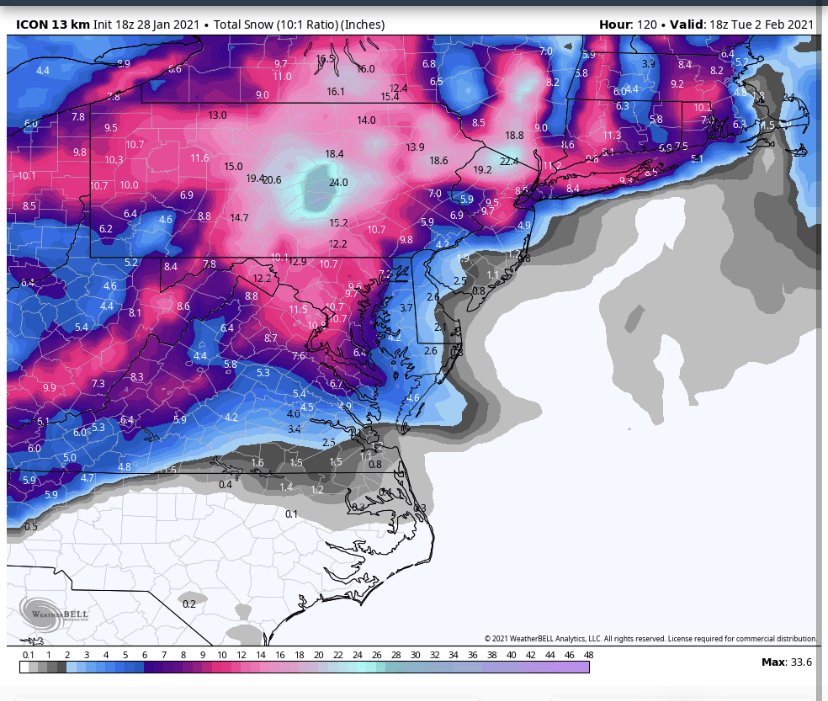
Im struggling to find the disaster.. Kuchera is even higher. Wasn't the GFS still showing a flush hit for Thursday this far out?? The ground floor of basically all guidance has been 3-6"..
It’s all relative to expectations. For those who saw the euro and banked it, this is a disappointment. Also, it’s salt in many wounds here as this perfectly portrays how a miller b can leave us on the outside looking in. This snow map presupposes we also accumulate from the back end band. A lot has to go right for this to verify. I think we would all happily take it though given where we’ve been the last few years. Some in here just want that euro run.
-
2
-
-
10 minutes ago, ryanconway63 said:
How reliable of a model is the NAVGEM its Very Bullish on the Big Storm/Slow Crawl Idea, looks like it would destroy Richmond to NY even though it only goes out to 144
Tarot cards come to mind.
-
Just now, Bubbler86 said:
Icon was way north with that lead wave at 18z as well. It does not seem to be hinting at any suppression.
I’m watching how much latitude the storm gets before reaching the coast. Too far north and the transfer misses us and we’re in the ripoff zone. Of course too far south and you get those suppression scenarios we saw in the eps members.
-
Icon behaving like a miller b in a Nina. Best snow to the NE.
-
1
-
-
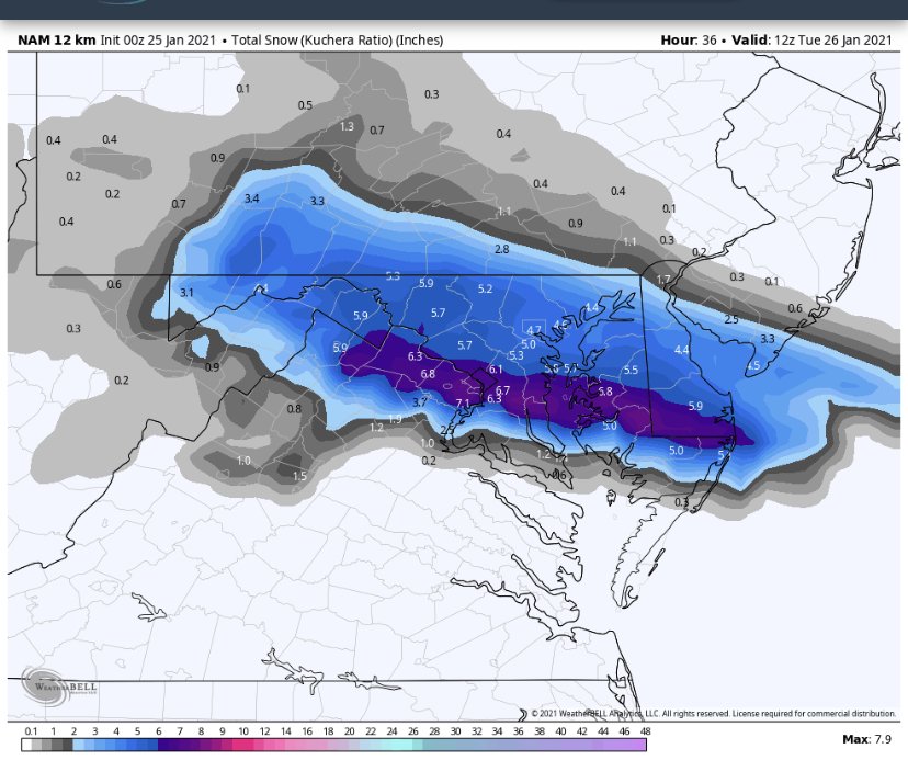
Hrrr has been trending less in the way of accumulating snow. Hopefully the nam gives us love again.
-
1
-
-
10 minutes ago, leesburg 04 said:
Other than it's the NAM why is it wrong?
There’s a better chance of earth getting hit by a gamma ray burst tomorrow than DCA getting 6-7 inches from this system.
-
 2
2
-
-
-
Just now, snowfan said:
It’s a shame you can’t believe the NAM. Otherwise, we’d be stoked for our 2-5” of snow.
Wait, DCA isn’t getting 6+ tomorrow night?
-
I’m looking forward to my 3-5 inches the nam has promised me tomorrow.
-
2
-
1
-
-
That energy dropping south of the Hudson Bay is robust this run. It’s almost spooky as it comes out of nowhere to screw us. This is getting painful.
-
Just now, NorthArlington101 said:
3k is great for MD. Think it was a step in the right direction. Plenty of time for this to get colder.Very nice trend
-
1
-
-
4 minutes ago, NorthArlington101 said:
12k NAM looks onboard with the thump. Surface looks slightly warmer but 850s slightly colder. Hopefully the NAMs smarter brother joins in.
3k a little warmer but nice to see the 12k join the euro.
-
9 minutes ago, CAPE said:
Its pretty pathetic, and it may dwindle even more. This system doesn't have a lot going for it.
It’s a prolific qpf producer and in a slightly colder airmass would be a huge score for us.
-
Let’s hope the freezing rain doesn’t materialize. Does absolutely nothing for snow lovers and just creates dangerous conditions. Rather have rain.


Jan 31 - Feb 2 Storm
in Mid Atlantic
Posted