

Negnao
-
Posts
271 -
Joined
-
Last visited
Content Type
Profiles
Blogs
Forums
American Weather
Media Demo
Store
Gallery
Posts posted by Negnao
-
-
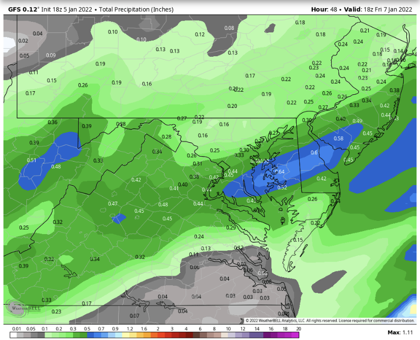
NWS lowered their totals. Generally 1-3 throughout central md and the cities.
-
 1
1
-
 1
1
-
-
1 minute ago, CentralVaNATS said:
Looks like that line right along or just 3 miles west of I95. From Dale city to fredericksburg /rt3
Sent from my SM-G998U using Tapatalk
No problem. They can handle it.
-
 1
1
-
 1
1
-
1
-
-
-
10
-
2
-
-
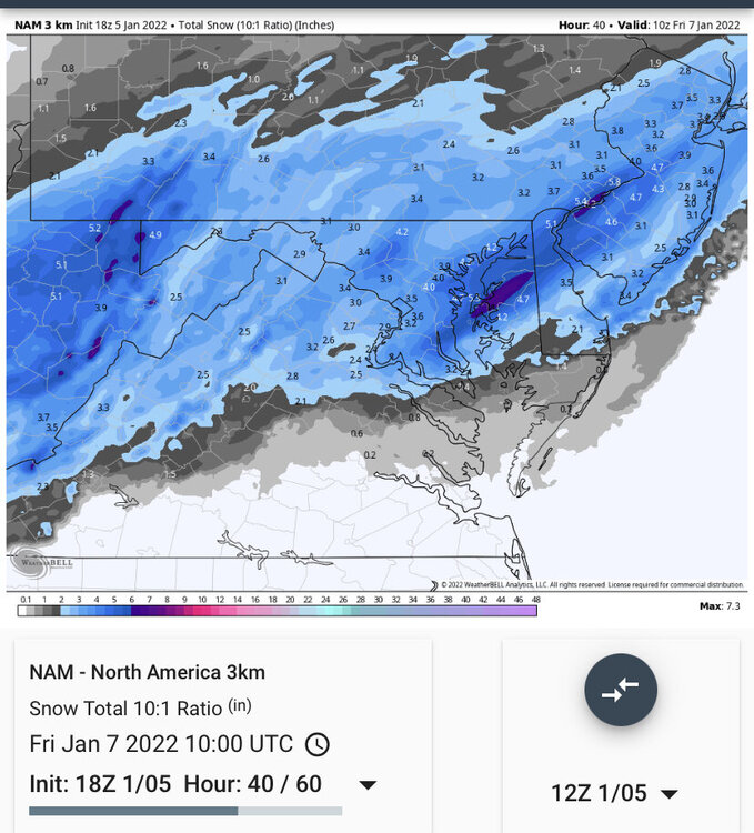
3k looks good.
-
7
-
-
Interesting that they(NWS) increased their high end (1 in 10 chance) to over 6 inches. It was a little lower earlier.
-
3 minutes ago, nj2va said:
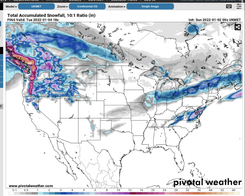
On the Meteocentre maps only (not the ‘prettier’ maps yet), but UKMET took a big jump NW as well.

Still a miss but a big jump nw
-
-
Just now, SnowenOutThere said:
When is a good time to get concerned about mixing for the cities, if this trend continues that is.
Never. It’s not the problem with this storm.
-
1
-
-
22 minutes ago, DCAlexandria said:
FWIW the 18Z GFS crushes us
Crushes?
-
7 minutes ago, psuhoffman said:
No but neither does a +AO. Most of the snows are when the AO is neg or neutral. Only a few near the top of that graph also. But look at the real issue…none if the AO is +4/5 just like none if the pna is -4/5 like now! If the PNA was +2 but the AO was +5 we would be screaming how we need the AO right now. Truth is we need more than one thing to have a good chance.
ETA: there is also a big difference between DCA where that chart was made from and the NW burbs. Places in our forum can do ok snow wise with a -pna -NAO so long as the NAO is more neg than the pna. Lots of 1-3” storms at DCA that were 4-8” not far NW of the beltway. DCA REALLY sucks. It has to be so perfect for it to snow a lot there.
DCA is terrible and I agree we can still score with a negative PNA and negative nao, but the PNA at -5 makes us all dead in the water. Hopefully we can at least get close to neutral in early January.
-
1
-
-
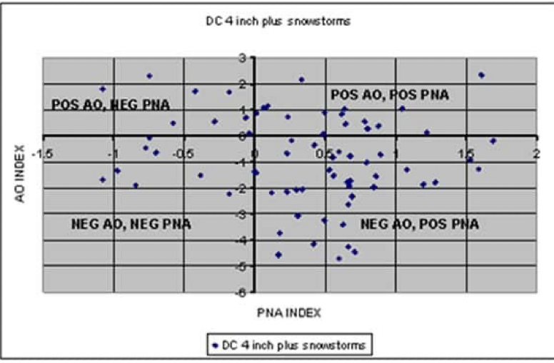
Negative PNA doesn’t work well for DC snowstorms. -
3 minutes ago, Wetbulbs88 said:
Yeah I'm seriously starting to realize how ungrateful I was while in NYC. This is just...Wow. I grew up in Ellicott City and didn't viscerally understand how bad it was just 20 miles south until experiencing it for myself.
The years you mentioned you were in nyc were also very cold in dc and snowy.
-
1 minute ago, WEATHER53 said:
My forecasts of problems around and within 15-20 miles of DC stemmed from this analog method
NEVER since 1975 has my station nor DCA EVER received 4” of more of snow when the daytime temperatures before the even have hit or exceeded 48F. Such an air mass has never supported that amount of snow. A few (3/4) had instances where a cold front moved thru after the 48 was hit or exceeded but that was Not the case in this situation
Veterans Day 87 was 63 the day before, wasn’t it?
-
 3k is tasty
-
2
-
1
-
-
2 minutes ago, snowmagnet said:
Well the Ukie and the RGEM regularly offered me about 13” last weekend, so they’ve lost my trust. Ended up with less than 6”.
I’m not saying they’re good models. Just seems like they are keying in on a trend of a less amplified system. Doesn’t seem as much interaction early enough with the ULL and doesn’t intensity as rapidly as earlier runs a day or two ago. Results in a track slightly southeast and weaker than prior runs.
-
UK looks like the Rgem-
4
-
2
-
-
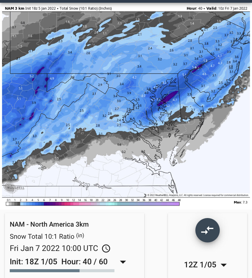
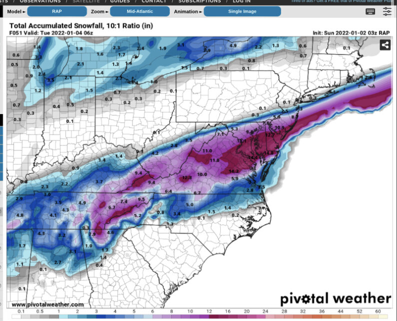
12z Rgem Kuchera

-
1
-
1
-
-
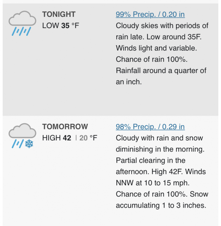
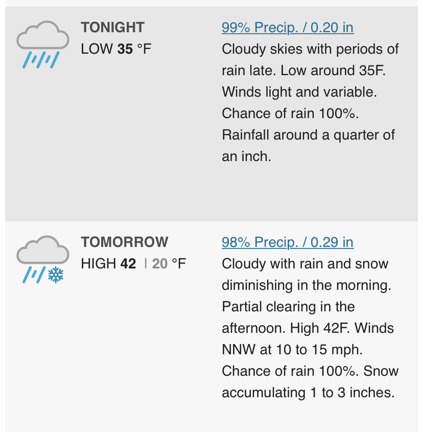
wunderground forecast for dc. Lol -
3 minutes ago, losetoa6 said:
Srefs juiced up from 3z . ARWs are uber wet lol
Arw Max stipe of qpf just nw of 95 all the way up the coast. Blended with other guidance, 95 looks like a solid hit. Just need thermals to cooperate.
-
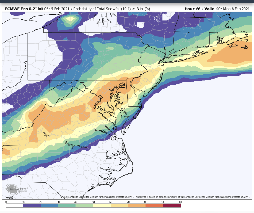
6z Eps > 3 inch probability
-
8
-
1
-
1
-
-
1 minute ago, psuhoffman said:
It looked like it there...but then the low took a NE instead of NNE track from NC and the heavy precip stayed southeast of 95. Close miss to the SE with the heavy snow.
Agreed. Looked good early but followed the trend of the rest of the 0z suite unfortunately.
-
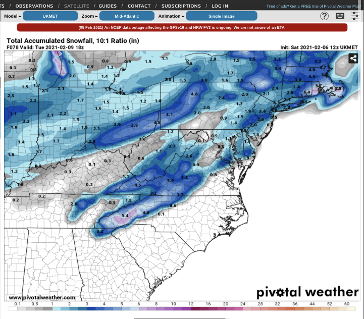
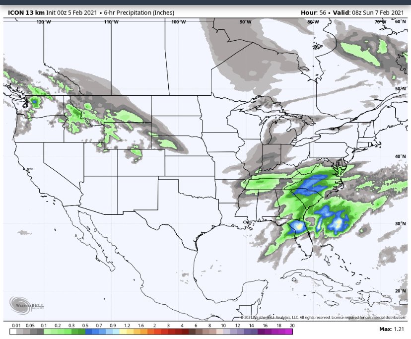
icon about to deliver a beat down
-
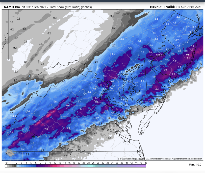
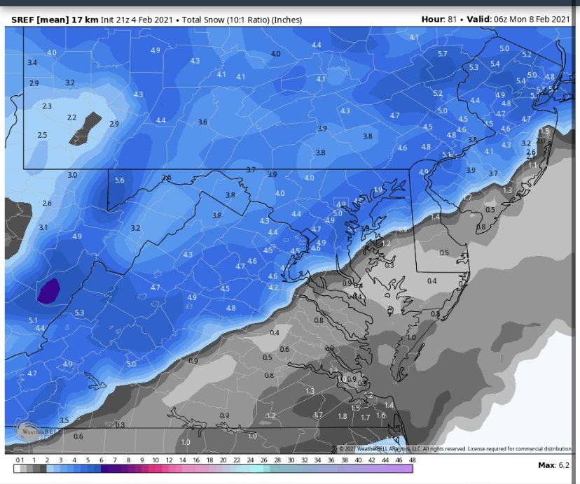
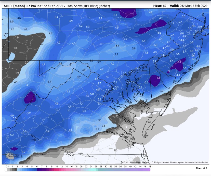
Top is 21z that just came out the bottom is 15z from this afternoon. Precip lighter on 21z as well.
-
1
-
-
7 minutes ago, Ravens94 said:
SREF mean went up pretty significantly
21z seems worse? Mean snowfall went down around dc and SE of town it dropped significantly.
Jan 6/7 "Event" and obs
in Mid Atlantic
Posted