

Negnao
-
Posts
271 -
Joined
-
Last visited
Content Type
Profiles
Blogs
Forums
American Weather
Media Demo
Store
Gallery
Posts posted by Negnao
-
-
2 minutes ago, chris21 said:
I know this has been hashed and rehashed but the long term avg at DCA is not really representative of even downtown though. NW DC is prob closer to 20. For instance, in this past storm I measured 5.5 inches while DCA measured 3.2. In 2016, there was a uniform 23-26 inches in NW, while DCA recorded 16.
Exactly right. Dca isn’t even representative of the entire city. It’s really an island to itself which is why we should let people who care about science have the official reporting site at the zoo.
-
Surprised we can’t even get sleet here in Rockville. Freezing rain still.
-
2 minutes ago, NattyBo said:
Precip has totally shut off in my neck of Rockville
Very light here.
-
Light freezing drizzle in Rockville. Some pellets here and there.
-
3 minutes ago, MDSnowyWxTracker said:
Back to snow in Urbana now. 28/27
In my office in Rockville and it’s freezing rain here.
-
Shame we don’t have the column. Moderate freezing rain.
-
Just now, BTRWx's Thanks Giving said:
What a horrible model. I have never seen the CMC get a storm right when others didn't.
That includes a storm on 2/7
-
 1
1
-
 1
1
-
-
Now might be a good time for NWS to downgrade to a winter weather advisory. Save some face. Talking about dc metro.
-
1
-
 1
1
-
-
A few flakes sporadically falling in Potomac.
-
6 minutes ago, Wetbulbs88 said:
I offered one opinion on one model...I've posted here several times tonight and am clearly not a troll. I have no problem with any of you and all of you just jumped down my throat for what I think is a very objective take. I'll let you decide whether you think that's okay. But I'm not going anywhere.
Nyc took the storm the euro promised us for days. Caught us at a bad time.
-
1
-
-
Just now, LeesburgWx said:
So we went from rgem to hugging the icon now? We are in desperate times. But Icon does look nice so I hug
Icon is the only model that matters.
-
 4
4
-
 1
1
-
-
1 minute ago, pazzo83 said:
There was actually some research done showing that upper NW was part of the city with a much weaker UHI.
Wish we could have an official reporting site up there near the zoo or rock creek park that would have less river and urban heat influence. Like Central Park in nyc. Seems it would be a more accurate measurement for snowfall at least.
-
1 minute ago, Ravens94 said:
Finnaly out hail Canada

Looks like the low gets captured and stalls and even retrogrades. That was the PSU boom scenario the other day he spoke about after the suppressed euro run.
-
1
-
-
Just now, clskinsfan said:

That low just stalls there. On the NAM it races ene.
-
2
-
-
Just now, clskinsfan said:
18z RGEM continues the DC and north mauling this run. Geez.
It’s the only model that matters. Toss everything else.
-
2
-
2
-
-
1 minute ago, Weather Will said:
I know it is getting too close in for EPS ensembles but some RGEM hits in there...


That’s 6z not 12z
-
1
-
 1
1
-
-
Just now, Crazy4Wx said:
How good is the RGEM at this range?
Those details don’t matter. Just enjoy it.
-
2
-
4
-
1
-
-
Hrrr long range is a a solid 5-6 inches for dc metro before any mixing. One part of the storm we need to produce is the thump so that’s reassuring even though it’s the hrrr at range.
-
1
-
-
3 minutes ago, yoda said:

Where do we sign? Great run for dc.
-
4
-
-
Rgem is better for the northeast and NE md (for our forum) and about the same or so for dc and south. Maybe a little worse dc and south.
-
1
-
1
-
-
1 minute ago, Wonderdog said:
Just remember, it's a Miller B.
That’s why I liked the euro runs with a weaker coastal that went E rather than NE up the coast from our latitude. Wasn’t a blockbuster but it was clean.
-
4 minutes ago, psuhoffman said:
yes but the euro trended a little better this run. It was the first time it nudged the "other way" in 36 hours. The trend is USUALLY (not always) to relax features up there a little at the last minute. Not a ton but usually once you get inside 48 hours you see some relaxation of the flow to the northeast as the next wave approaches. This isn't any great insight just stating typical model bias over the years...of course every situation is unique. I was happy to see the euro start to back down with that crushing feature even if just a little. If you loop the H5 trend at 72 hours from the last 3 runs its a little closer to a better phase for us imo.
I guess it all depends on where you live but for dc proper the 6z Euro run and more suppressive look was cleaner.
-
1 minute ago, psuhoffman said:
Look at the icon and Ukmet...even the gfs somewhat. We can ALL win with a more amplified solution so long as we can stomach a few hours of sleet or drizzle.
Dc loses 850s for 6-10 hours on the uk with some decent rain/mix. Euro had dc below freezing for the most part for the entire column during this time. Hopefully the euro thermals are right.
-
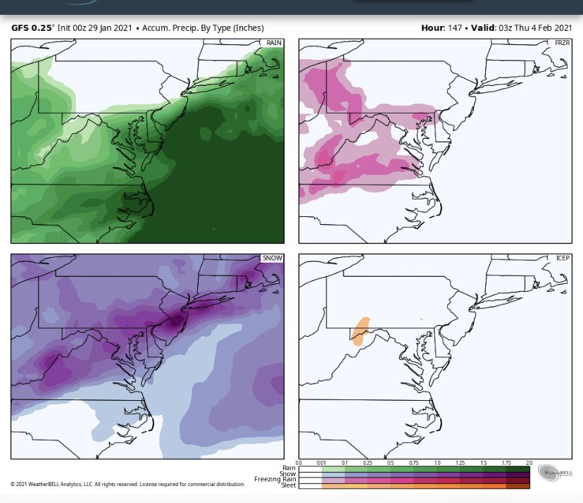
5 minutes ago, LP08 said:
Gefs mean temps are quite warm. Over 1.2” of precip but barely 6” on the snow mean.
I know we shouldn’t use mean temps but its something.
This is the gfs, not the ensembles, but this panel shows how much rain falls. Around an inch of rain in the dc metro.


Feb Long Range Discussion (Day 3 and beyond) - MERGED
in Mid Atlantic
Posted
Remember that marginal storm in 2010 that produced around here before the big storms? Maybe we’re about to see a redux.