

Negnao
-
Posts
271 -
Joined
-
Last visited
Content Type
Profiles
Blogs
Forums
American Weather
Media Demo
Store
Gallery
Posts posted by Negnao
-
-
1 hour ago, pazzo83 said:
it's representative of the million people who live in DC/Arlington/Alexandria, with some minor variation. It's not supposed to represent some way out suburb. We had these same arguments in the NYC forum where folks in like way out NW NJ were pissed at Central Park's climate record/obs/whatever. Well ok, it's the climate site for NYC not your random suburb. Sorry.
Central Park is not in a bad spot. Better than jfk. Not sure why people always complain about Central Park. The nyc equivalent of Dca would be 20 miles south of jfk in the ocean and it would never capture close events that snowed in the city. The snow mean would go down dramatically. At DCA every marginal event is missed even though you could have a mostly region wide snow event.
-
1 minute ago, pazzo83 said:
yeah no buses, most kids walk/take public transit. Although a good number of kids are driven to school.
Makes no sense to close an urban district with no rural bus routes for 1-3/2-4 inches of snow. It would be embarrassing if they did close.
-
 This may be the most disturbing panel I’ve seen tonight. So close. Total screw job.
-
 1
1
-
-
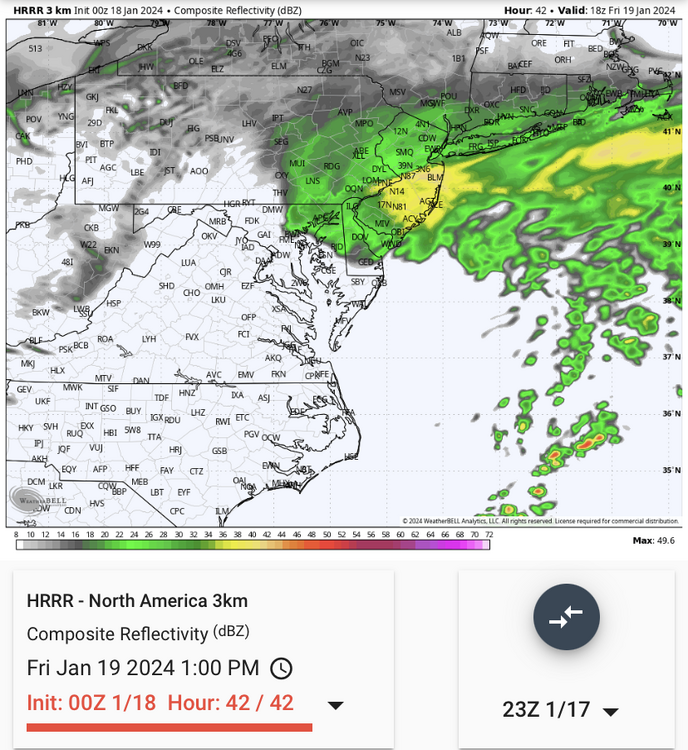
5 minutes ago, clskinsfan said:
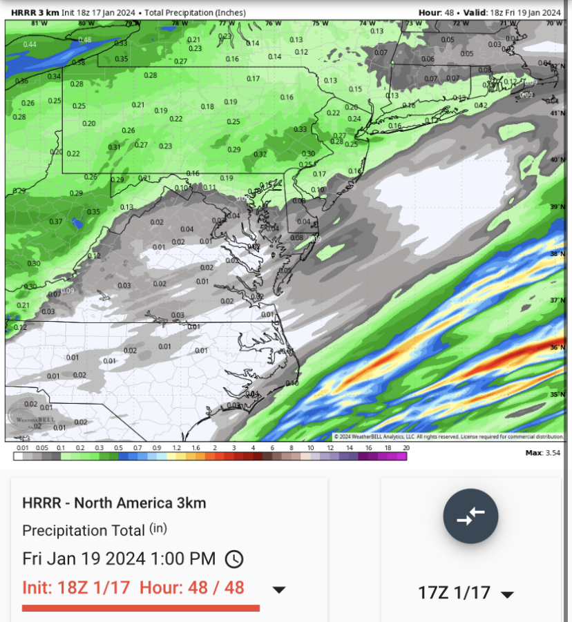
HRRR is better. At least it gives us snow. Unlike 12Z. But it is still dry as a popcorn fart.
 Not that dry to the north of us. Just too far north. Not good for us.
-
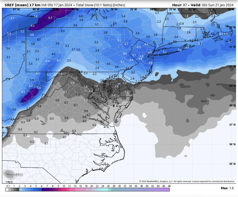 Sref mean.
-
 1
1
-
-
7 minutes ago, Steve25 said:
Any official reports from the airports?
At midnight bwi and IAD had 4.1 and DCA had 3.4.
-
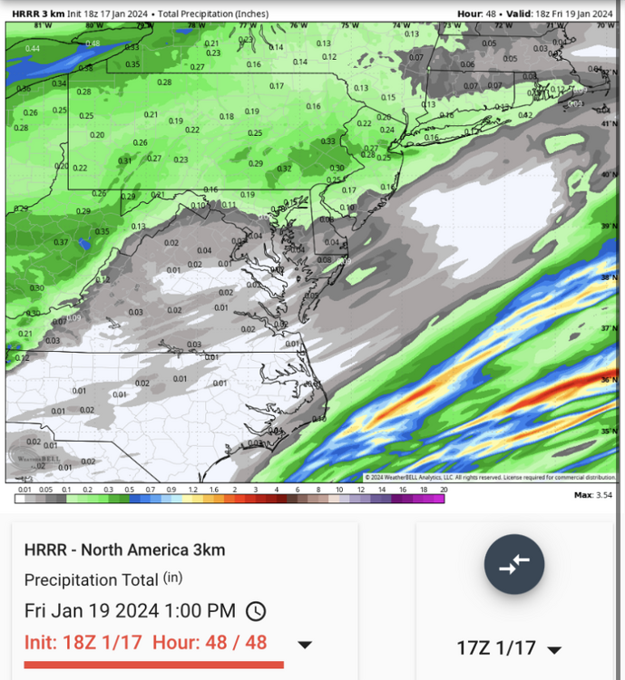
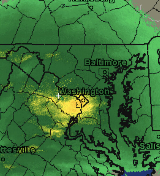
 dc under another heavy band. Setup nicely for dc metro today. Must be heavy rain in Georgetown.
-
1
-
 1
1
-
-
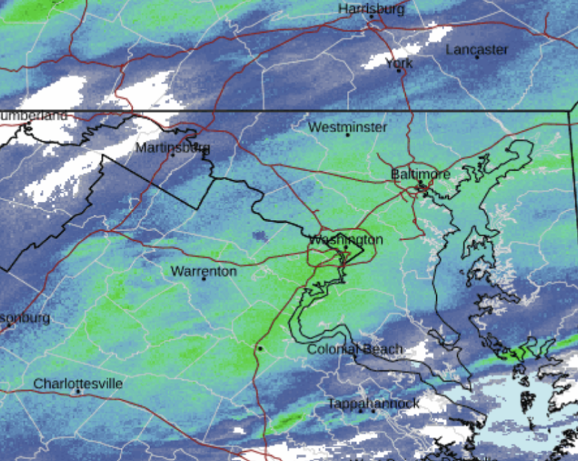
2 minutes ago, konksw said:
Are you sure you aren’t in an alternate dimension or something? That’s a wild meso feature as the whole district is covered on radar.
He’s probably the guy that does the measurements at DCA.
-
1
-
-
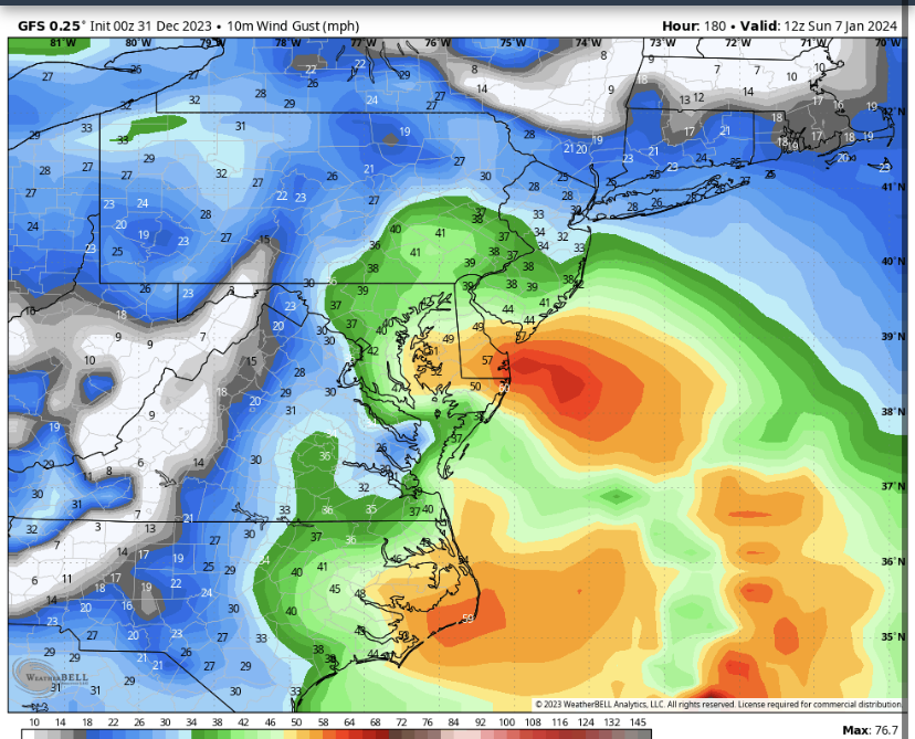 Check out the wind gusts while it’s pouring snow. Would be a fun storm.
-
5
-
 1
1
-
-
-
-
Snow climo down here is not as robust as Philly (grew up in Roxborough/Manayunk). If we manage a 4" - 8" storm out of this for Christmas proper, it will exceed norms for IAD, BWI, DCA. That's a win in my book.
Philadelphia normal annual snowfall is 22.4 and Washington Dulles is 21. Wilmington is 20.2 and Baltimore BWI is 19.3. Very similar.
. -
The rap looks sweet.
-
2
-
-
38 minutes ago, SnowGoose69 said:
their storm total should be 8.7 as of 1pm as they reported 7.5 at 1pm and had 1.2 yesterday. The 420 climate report though has 7.3 which makes no sense...should be about 8-8.2 for today as both LGA and JFK added around 0.5-1.0 from their 1pm total
7.5 storm total(not daily)as of 1pm including the 1.2 from yesterday. So 7.3 today and 1.2 yesterday makes 8.5 total for the storm.
-
Logan has 12.2 inches season to date and DCA has 12.1. We should be happy where we are so far.
-
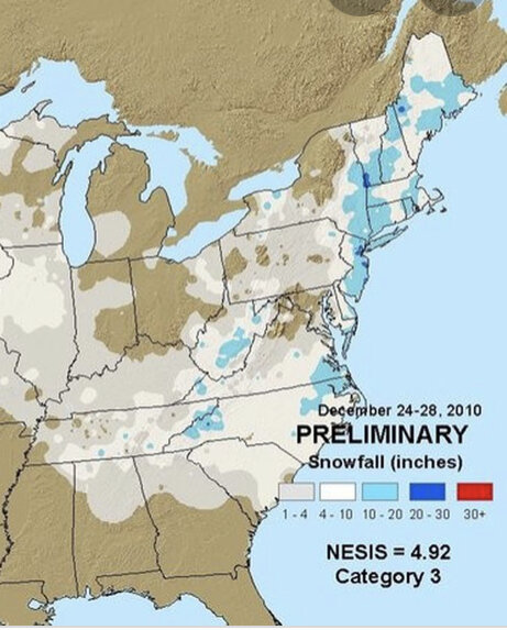
I’d prefer no storm over a Dec 2010 redux.
-
2
-
3
-
-
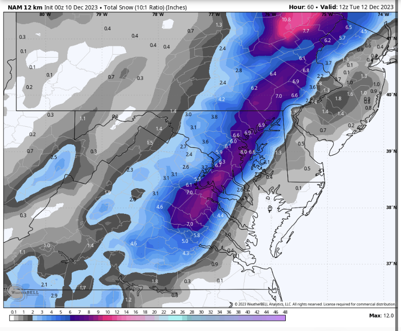
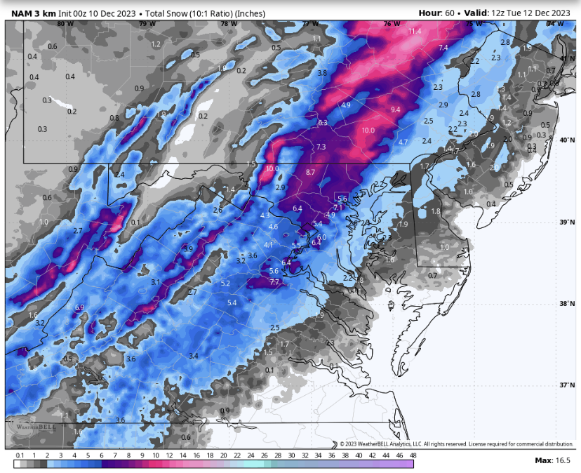
Nam doing nam things
-
We do lose the column on the control.
-
1
-
3
-
2
-
-
3 minutes ago, MN Transplant said:
Bigger flakes. Grass starting to get covered.
Grass is just now getting covered? Urban heat island is crazy.
-
Any reports from inside of dc under this band?
-
Just now, ravensrule said:
I have quit the cheesy sex jokes, since the point and click forecast maven has insulted me greatly.
You wonder why the forum will never grow. You’re the reason.
-
2
-
-
2 minutes ago, mappy said:
Point and click forecasts never match up exactly with the words in products issued to the public. Rely more on the advisory package wording, and their updated snowfalls maps, than your point and click. Point and click are pulled from models and not human entered.
I was using their probability page for the national mall as an example. Anyway I was just making the point we all knew- that the models are less bullish today and the NWS took notice.
-
2 minutes ago, ravensrule said:
Ah so the advisory they put out after seeing today's models don't reflect their true opinion. Makes sense.
The expected snowfall at the national mall went from 4 inches to 2 inches. Please make cheesy sex jokes instead of harassing other posters. Stick wirh what works for you.
-
 2
2
-
-
Just now, ravensrule said:
At least be correct if you are going to post something.
URGENT - WINTER WEATHER MESSAGE
National Weather Service Baltimore MD/Washington DC
328 PM EST Thu Jan 6 2022

DCZ001-MDZ005-006-008-011-013-014-016-018-503>508-VAZ052>054-502-
506-071200-
/O.EXT.KLWX.WW.Y.0003.220107T0200Z-220107T1200Z/
District of Columbia-Carroll-Northern Baltimore-Cecil-
Southern Baltimore-Prince Georges-Anne Arundel-Charles-Calvert-
Northwest Montgomery-Central and Southeast Montgomery-
Northwest Howard-Central and Southeast Howard-Northwest Harford-
Southeast Harford-Prince William/Manassas/Manassas Park-Fairfax-
Arlington/Falls Church/Alexandria-Southern Fauquier-
Eastern Loudoun-
328 PM EST Thu Jan 6 2022

...WINTER WEATHER ADVISORY NOW IN EFFECT FROM 9 PM THIS EVENING
TO 7 AM EST FRIDAY...

* WHAT...Snow accumulations of 2 to 4 inches.

* WHERE...The Washington and Baltimore Metropolitan areas,
  portions of central and southern Maryland, and portions
  northern Virginia.

* WHEN...From 9 PM this evening to 7 AM EST Friday.

* IMPACTS...Plan on slippery road conditions. The hazardous
  conditions could impact the morning commute.

* ADDITIONAL DETAILS...The heaviest snow is expected overnight
  when snowfall rates of 1 inch per hour are possible. Visibility
  will be reduced to near or less than one-half mile.
In the actual forecast, not the advisory, it went from 2-4 to 1-3. It changed. It’s relevant as it reflects their thinking after today’s models.
-
1
-
1
-


The Weekend Rule? Saturday 2/17 - The Icon Storm
in Mid Atlantic
Posted
Surprised there’s not more panic about the north trend. The wiggle room for dc is gone.