

RVASnowLover
-
Posts
1,245 -
Joined
-
Last visited
Content Type
Profiles
Blogs
Forums
American Weather
Media Demo
Store
Gallery
Everything posted by RVASnowLover
-
Worse case scenario
-
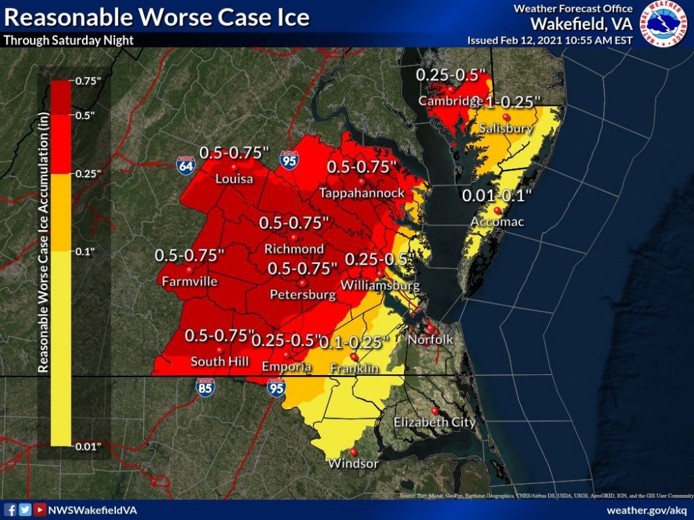
Yup and like I said, Wakefield is usually very conservative when it comes to big events so for them to issue their first ever ice storm warning, that's telling
-
Yeah ever since the model let him down and he got burned by it it’s like he’s angry at the models now and doesn’t want to trust them. Now he’s not saying there won’t be ice but he is downplaying the ice storm warning
-
-
Looks like all 18z short range models are still showing a significant ice storm
-
I agree. Not sure why he’s downplaying it
-
I think he’s down playing getting that much ice because some models are showing temps at 32 for some areas so will be close. First ever ice storm warning issued by Wakefield and they are usually conservative so they must see this as a significant event
-
I read that too and it confused me. Not sure what data he’s looking at. Almost all the short range models are showing at least .25 of ice
-
18z NAM still showing between .25-.50 of ice from Richmond down to Petersburg
-
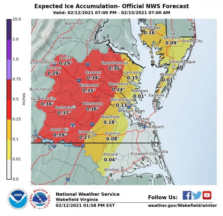
Even 10-15 mph gust can cause problems since trees are already weighed down with snow. Add .25-.50 of ice to that and even a little wind can cause a lot of problems
-
Both GFS and NAM show significant ice storm tomorrow
-
HRRR showing snow for another 3-4 hours? Looks amazing outside right now
-
Thanks. Nice to finally have some good snow after last season.
-
Heavy snow with huge flakes now
-
Heavy snow now
-
Best rates happening now. Radar looks good
-
Based on radar we should be in good rates for awhile
-
Nice
-
May be Getting another little lull here soon
-
It looks like on radar the mix line is somewhere around the Midlo area
-
I think it depends on what kind of rates we get. If we can get good rates I think 4 is possible in the city. If we long periods of pixie dust than yeah probably more like 3
-
Looking at around 3-4 am for that?
-
HRRR has about another 3"
-
Rates have been on and off. Great rates for a little while, then pixie dust, then great rates
-
Rain earlier definitely affected accumulation on roads and sidewalks.


